Dorset Council (Australia)
| Dorset Council Tasmania | |||||||||||||||
|---|---|---|---|---|---|---|---|---|---|---|---|---|---|---|---|
|
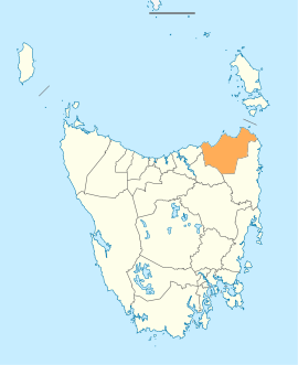
Map showing the Dorset local government area. | |||||||||||||||
| Coordinates | 41°04′14″S 147°42′32″E / 41.0706°S 147.7089°ECoordinates: 41°04′14″S 147°42′32″E / 41.0706°S 147.7089°E | ||||||||||||||
| Population | 6,617 (2016)[1] | ||||||||||||||
| • Density | 2.1/km2 (5.4/sq mi) | ||||||||||||||
| Established | 2 April 1993[2] | ||||||||||||||
| Area | 3,196 km2 (1,234.0 sq mi) | ||||||||||||||
| Mayor | Greg Howard | ||||||||||||||
| Council seat | Scottsdale | ||||||||||||||
| Region | North-east Tasmania | ||||||||||||||
| State electorate(s) | Bass | ||||||||||||||
| Federal Division(s) | Bass | ||||||||||||||
|
| |||||||||||||||
| Website | Dorset Council | ||||||||||||||
| |||||||||||||||
Dorset Council is a local government body in Tasmania, located in the far north-east of the state mainland. Dorset is classified as a rural local government area and has a population of 6,617, the major towns and localities of the region include Bridport, Derby and Ringarooma with Scottsdale the regional centre.
History and attributes
The municipality was established on 2 April 1993 after the amalgamation of the Scottsdale and Ringarooma municipalities.[2] Dorset is classified as regional, agricultural and large (RAL) under the Australian Classification of Local Governments.[3]
Suburbs
| Locality | Census population 2016 | Reason |
|---|---|---|
| Bridport | 1568 | |
| Tomahawk | 48 | Includes The Chimneys |
| Boobyalla | 0 | |
| Cape Portland | 0 | |
| Musselroe Bay | 40 | |
| Rushy Lagoon | 30 | |
| The Chimneys | Incl. in Tomahawk | |
| Gladstone | 139 | |
| South Mount Cameron | 15 | |
| Banca | 0 | |
| Waterhouse | 90 | |
| Alberton | 0 | |
| Legunia | Incl. in Ringarooma | |
| South Springfield | 25 | |
| Springfield | 188 | |
| Lisle | 0 | |
| Nabowla | 112 | Includes Koomeela |
| Golconda | 26 | |
| Wyena | 24 | |
| Jetsonville | 137 | |
| Lietinna | 58 | |
| Blumont | 31 | |
| Scottsdale | 2373 | |
| Koomeela | Incl. in Nabowla | |
| Cuckoo | 53 | |
| Tonganah | 26 | |
| Tulendeena | 12 | |
| Ledgerwood | 193 | |
| Ringarooma | 338 | |
| Talawa | 53 | |
| Trenah | 11 | |
| Forester | 8 | |
| Branxholm | 267 | |
| Telita | 22 | |
| Warrentinna | 0 | |
| Winnaleah | 225 | |
| Moorina | 11 | |
| Herrick | 52 | |
| Pioneer | 89 | |
| North Scottsdale | 122 | |
| Kamona | 11 | |
| West Scottsdale | 58 | |
| Lebrina | 192 | |
| Tunnel | 73 | |
| Total | 6,720 | |
| (103) | Variance | |
| Local government total | 6,617 | Gazetted Dorset Local Government Area |
See also
References
- ↑ Australian Bureau of Statistics (27 June 2017). "Dorset". 2016 Census QuickStats. Retrieved 8 June 2016.

- 1 2 "Agency Details: Dorset Municipal Council". search.archives.tas.gov.au. Tasmanian Government. Retrieved 11 June 2018.
- ↑ "Local government national report 2014-2015". regional.gov.au. Australian Government. Retrieved 8 June 2018.
External links
- Dorset Council official website
- Local Government Association Tasmania
- Tasmanian Electoral Commission - local government
This article is issued from
Wikipedia.
The text is licensed under Creative Commons - Attribution - Sharealike.
Additional terms may apply for the media files.