City of Burnie
| Burnie City Council Tasmania | |||||||||||||||
|---|---|---|---|---|---|---|---|---|---|---|---|---|---|---|---|
|
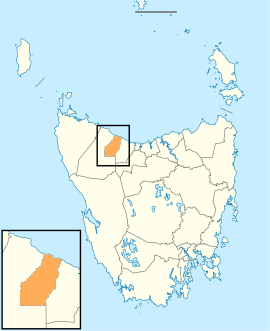
Map showing the Burnie local government area. | |||||||||||||||
| Coordinates | 41°12′56″S 145°48′23″E / 41.2156°S 145.8065°ECoordinates: 41°12′56″S 145°48′23″E / 41.2156°S 145.8065°E | ||||||||||||||
| Population | 18,895 (2016 census)[1] | ||||||||||||||
| • Density | 30.9/km2 (80/sq mi) | ||||||||||||||
| Established | 6 January 1908[2] | ||||||||||||||
| Area | 618 km2 (238.6 sq mi) | ||||||||||||||
| Mayor | Alvwyn Boyd | ||||||||||||||
| Council seat | Burnie | ||||||||||||||
| Region | Burnie and surrounds | ||||||||||||||
| State electorate(s) | Braddon | ||||||||||||||
| Federal Division(s) | Braddon | ||||||||||||||
|
| |||||||||||||||
| Website | Burnie City Council | ||||||||||||||
| |||||||||||||||
Burnie City Council (or City of Burnie) is a local government body in Tasmania, located in the city and surrounds of Burnie in the north-west of the state. The Burnie local government area is classified as urban and has a population of 18,895, which also encompasses Cooee, Hampshire, Natone and Ridgley.
History and attributes
The municipality was established on 6 January 1908. Originally named Emu Bay, the name was changed to Burnie in 1931 following a petition from residents to name the council based on the town it was centred on.[2][3] Burnie became a city council on 26 April 1988.[4]
The city's motto is "non nobis solum" (not for ourselves alone); for many years this was on the council seal but in 1992 a new, more colourful logo was created that did not include the motto. It did also not include the emu (which had been Burnie's unofficial animal emblem). Burnie's floral emblem is the rhododendron.
Burnie is classified as urban, regional and small (URS) under the Australian Classification of Local Governments.[5] Burnie does not include the adjacent town of Somerset that is sometimes classed as part of the Burnie metropolitan area.
Government

The Burnie City Council consists of nine aldermen, who each serve a four-year term of office; Ald. Alvwyn Boyd was elected as Burnie's Mayor in December 2017, after previous mayor Anita Dow resigned in October to contest the 2018 state election. The Deputy Mayor is Ald. Sandra French. The other members are:
| Name | Position[6] | Party affiliation | |
|---|---|---|---|
| Alvwyn Boyd | Mayor/Alderman | Independent | |
| Sandra French AM | Deputy Mayor/Alderman | Independent | |
| Robert Bentley | Alderman | Independent | |
| Ron Blake | Alderman | Independent | |
| Teeny Brumby | Alderman | Independent | |
| Ken Dorsey | Alderman | Independent | |
| Amina Keygan | Alderman | Independent | |
| Steve Kons | Alderman | Independent | |
| Chris Lynch | Alderman | Independent | |
Suburbs
Burnie Council recognises the following suburbs:[7]
| Suburb | Census population 2011 | Reason |
|---|---|---|
| Burnie | 696 | |
| Acton | 1,547 | |
| Cooee | 559 | |
| Emu Heights | 209 | |
| Downlands | 237 | |
| Chasm Creek | Includes in Wivenhoe | |
| Mooreville | 418 | Includes West Mooreville |
| West Mooreville | Included in Mooreville | |
| Ridgley | 746 | Includes East Ridgley |
| East Ridgley | Included in Ridgley | |
| West Ridgley | Included in Highclere | |
| Highclere | 399 | Includes West Ridgley, Tewkesbury, Hampshire |
| Tewkesbury | Included in Highclere | |
| Upper Stowport | Included in Natone | |
| Natone | 464 | Includes Upper Stowport, Upper Natone |
| Upper Natone | Included in Natone | |
| South Burnie | 367 | |
| Upper Burnie | 1,761 | |
| Hillcrest | 1,078 | |
| Brooklyn | 606 | |
| Romaine | 1,738 | |
| Montello | 1,197 | |
| Parklands | 815 | |
| Shorewell Park | 2,032 | |
| Havenview | 709 | |
| Wivenhoe | 450 | Includes Round Hill, Chasm Creek |
| Round Hill | Includes Wivenhoe | |
| Park Grove | 2,358 | |
| East Cam | 182 | |
| Camdale | Includes Ocean Vista | |
| Ocean Vista | 358 | Includes Camdale |
| Hampshire | Included in Highclere | |
| Stowport | 398 | Includes Glance Greek |
| Glance Creek | Included in Stowport | |
| Total | 19,324 | |
| 5 | Variance | |
| Local government total | 19,329 | Gazetted Burnie Local Government Area |
See also
References
- ↑ Australian Bureau of Statistics (27 June 2017). "Burnie (C)". 2016 Census QuickStats. Retrieved 23 November 2017.

- 1 2 "Agency Details: Emu Bay Municipal Council". search.archives.tas.gov.au. Tasmanian Government. Retrieved 11 June 2018.
- ↑ "Agency Details: Burnie Municipal Council". search.archives.tas.gov.au. Tasmanian Government. Retrieved 11 June 2018.
- ↑ "Agency Details: Burnie City Council". search.archives.tas.gov.au. Tasmanian Government. Retrieved 11 June 2018.
- ↑ "Local government national report 2014-2015". regional.gov.au. Australian Government. Retrieved 8 June 2018.
- ↑ "Elected Representatives - Burnie City". burnie.net. Burnie City Council. Retrieved 1 February 2015.
- ↑ Burnie City Council (20 November 2014). "Burnie Council Map" (PDF). Retrieved 26 July 2015.
External links
- Burnie City Council official website
- Local Government Association Tasmania
- Tasmanian Electoral Commission - local government