County Wexford
| County Wexford Contae Loch Garman | ||
|---|---|---|
| ||
|
Motto(s): Exemplar Hiberniae (Latin) "An example to Ireland" "Sampla na hÉireann" | ||
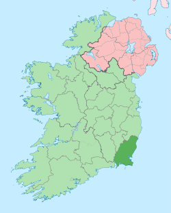 Location in Ireland | ||
| Coordinates: 52°30′N 6°45′W / 52.5°N 6.75°WCoordinates: 52°30′N 6°45′W / 52.5°N 6.75°W | ||
| Country | Ireland | |
| Province | Leinster | |
| Dáil Éireann | Wexford | |
| EU Parliament | South | |
| County town | Wexford | |
| Government | ||
| • Type | County Council | |
| Area | ||
| • Total | 2,365 km2 (913 sq mi) | |
| Area rank | 13th | |
| Population (2016)[1] | 149,605 | |
| • Rank | 14th[2] | |
| Vehicle index mark code | WX | |
| Website |
www | |

County Wexford (Irish: Contae Loch Garman) is a county in Ireland. It is in the province of Leinster and is part of the South-East Region. It is named after the town of Wexford and was based on the historic Gaelic territory of Hy Kinsella (Uí Ceinnsealaigh), whose capital was Ferns.[3][4] Wexford County Council is the local authority for the county. The population of the county is 149,605 according to the 2016 census.[5]
History


The county is rich in evidence of early human habitation.[6] Portal tombs (sometimes called dolmens) exist at Ballybrittas (on Bree Hill)[7] and at Newbawn[8] — and date from the Neolithic period or earlier. Remains from the Bronze Age period are far more widespread.[6] Early Irish tribes formed the Kingdom of Uí Cheinnsealaig, an area that was slightly larger than the current County Wexford.
County Wexford was one of the earliest areas of Ireland to be Christianised, in the early 5th century. Later, from 819 onwards, the Vikings plundered many Christian sites in the county.[9] Wexford town became a Viking settlement near the end of the 9th century.[9]
Wexford was the site of the invasion of Ireland by Normans in 1169 at the behest of Diarmuid Mac Murrough, King of Uí Cheinnsealaig and king of Leinster (Laigin), which led to the subsequent colonisation of the country by the Anglo-Normans.
The native Irish began to regain some of their former territories in the 14th century, especially in the north of the county, principally under Art MacMurrough Kavanagh. Under Henry VIII the great religious houses were dissolved, 1536–41; in County Wexford this included Glascarrig Priory, Clonmines Priory, Tintern Abbey, and Dunbrody Abbey.
On 23 October 1641, a major rebellion broke out in Ireland, and County Wexford produced strong support for Confederate Ireland. Oliver Cromwell and his English Parliamentarian Army arrived 1649 in the county and captured it. The lands of the Irish and Anglo-Normans were confiscated and given to Cromwell's soldiers as payment for their service in the Parliamentarian Army. At Duncannon, in the south-west of the county, James II, after his defeat at the Battle of the Boyne, embarked for Kinsale and then to exile in France.
County Wexford was the most important area in which the Irish Rebellion of 1798 was fought, during which significant battles occurred at The Battle of Oulart Hill took place near Oulart during the 1798 rebellion. Vinegar Hill (Enniscorthy) and New Ross. The famous ballad Boolavogue was written in remembrance of the Wexford Rising. At Easter 1916, a small rebellion occurred at Enniscorthy town, on cue with that in Dublin.[10] During World War II, German planes bombed Campile.[11][12] In 1963 John F. Kennedy, then President of the United States, visited the county and his ancestral home at Dunganstown, near New Ross.
Geography and political subdivisions
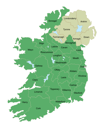
Wexford is the 13th largest of Ireland's thirty-two counties in area and 14th largest in terms of population.[13] It is the largest of Leinster's 12 counties in size, and fourth largest in terms of population. The county is located in the south-east corner of the island of Ireland. It is bounded by the sea on two sides—on the south by the Atlantic Ocean and on the east by St. George's Channel and the Irish Sea. The River Barrow forms its western boundary. The Blackstairs Mountains form part of the boundary to the north, as do the southern edges of the Wicklow Mountains. The adjoining counties are Waterford, Kilkenny, Carlow and Wicklow.
Towns and villages
| Historical population | ||
|---|---|---|
| Year | Pop. | ±% |
| 1500 | 4,550 | — |
| 1510 | 4,344 | −4.5% |
| 1550 | 5,010 | +15.3% |
| 1580 | 6,224 | +24.2% |
| 1585 | 9,870 | +58.6% |
| 1600 | 12,343 | +25.1% |
| 1610 | 3,456 | −72.0% |
| 1653 | 13,004 | +276.3% |
| 1659 | 11,680 | −10.2% |
| 1668 | 13,351 | +14.3% |
| 1672 | 15,339 | +14.9% |
| 1680 | 29,875 | +94.8% |
| 1690 | 36,310 | +21.5% |
| 1700 | 48,660 | +34.0% |
| 1705 | 52,399 | +7.7% |
| 1710 | 68,980 | +31.6% |
| 1715 | 71,445 | +3.6% |
| 1720 | 79,880 | +11.8% |
| 1725 | 83,455 | +4.5% |
| 1735 | 88,611 | +6.2% |
| 1745 | 87,222 | −1.6% |
| 1755 | 84,114 | −3.6% |
| 1765 | 81,396 | −3.2% |
| 1771 | 84,233 | +3.5% |
| 1775 | 87,222 | +3.5% |
| 1781 | 90,566 | +3.8% |
| 1788 | 104,760 | +15.7% |
| 1790 | 125,881 | +20.2% |
| 1801 | 120,688 | −4.1% |
| 1811 | 131,970 | +9.3% |
| 1813 | 128,455 | −2.7% |
| 1816 | 141,389 | +10.1% |
| 1821 | 155,377 | +9.9% |
| 1821 | 170,806 | +9.9% |
| 1831 | 182,713 | +7.0% |
| 1841 | 202,033 | +10.6% |
| 1851 | 180,158 | −10.8% |
| 1861 | 143,954 | −20.1% |
| 1871 | 132,666 | −7.8% |
| 1881 | 123,854 | −6.6% |
| 1891 | 111,778 | −9.8% |
| 1901 | 104,104 | −6.9% |
| 1911 | 102,273 | −1.8% |
| 1926 | 95,848 | −6.3% |
| 1936 | 94,245 | −1.7% |
| 1946 | 91,855 | −2.5% |
| 1951 | 90,032 | −2.0% |
| 1956 | 87,259 | −3.1% |
| 1961 | 83,308 | −4.5% |
| 1966 | 83,437 | +0.2% |
| 1971 | 86,351 | +3.5% |
| 1979 | 96,421 | +11.7% |
| 1981 | 99,081 | +2.8% |
| 1986 | 102,552 | +3.5% |
| 1991 | 102,069 | −0.5% |
| 1996 | 104,371 | +2.3% |
| 2002 | 116,596 | +11.7% |
| 2006 | 131,749 | +13.0% |
| 2011 | 145,320 | +10.3% |
| 2016 | 149,605 | +2.9% |
| [14][15][16][17][18][19] | ||
- Adamstown
- Arthurstown
- Ballycanew
- Ballycullane
- Ballyedmond
- Ballyfad
- Ballygarrett
- Ballyhack
- Ballymitty
- Ballywilliam
- Bannow
- Blackwater
- Bree
- Bridgetown
- Broadway
- Bunclody
- Camolin
- Campile
- Castlebridge
- Castletown
- Cleariestown
- Clohamon
- Clonroche
- Coolgreany
- Courtown
- Craanford
- Crossabeg
- Cullenstown
- Curracloe
- Duncannon
- Duncormick
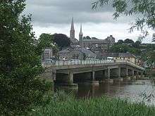
- Enniscorthy
- Ferns
- Fethard-on-Sea
- Foulkesmill
- Gorey
- Hollyfort
- Inch
- Killinierin
- Kilmore
- Kilmore Quay
- Kilmuckridge
- Kiltealy
- Monamolin
- Monaseed
- Murrintown
- Monageer
- Monbeg
- Newbawn
- New Ross
- Oulart
- Oylegate
- Poulpeasty
- Rathangan
- Rosslare
- Rosslare Harbour
- Raheen
- Rathnure
- Saltmills
- Taghmon
- Watch House Village
- Wellingtonbridge
- Wexford
County Wexford is known as Ireland's "sunny southeast" because, in general, the number of hours of sunshine received daily is higher than in the rest of the country. This has resulted in Wexford becoming one of the most popular places in Ireland in which to reside. The county has a mild, but changeable, oceanic climate with few extremes. The North Atlantic Drift, a continuation of the Gulf Stream, moderates winter temperatures. There is a meteorological station located at Rosslare Harbour.[20] January and February are generally the coldest months, with temperatures ranging between 4–8 °C on average.[21] July and August are generally the warmest months, with temperatures ranging between 12–18 °C on average.[21] The prevailing winds are from the south-west.[22] Precipitation falls throughout the year. Mean Annual Rainfall is between 800–1200 mm.[23] Generally, the county receives less snow than more northerly parts of Ireland. Serious snowfalls are relatively rare, but can occur. The one exception is Mount Leinster, visible from a large portion of the county, which is frequently covered with snow during the winter months. Frost is frequent in winter months, less in coastal areas.
Mountains and hills

Largely low-lying fertile land is the characteristic landscape of the county. The highest point in the county is Mount Leinster (795 m,[24] 2610 ft) in the Blackstairs Mountains in the north-west on the boundary with County Carlow.
Other high points:
- Black Rock Mountain, which is 599 m (1,965 ft) high. It is located near the Wexford-Carlow border, within County Wexford.
- Croghan Mountain (or Croghan Kinsella) on the Wexford-Wicklow border - 606 m (1,988 ft) high
- Annagh Hill 454 m (1,490 ft), near the Wicklow border
- Slieveboy at 420 m (1,378 ft) high
Notable hills include: Carrigbyrne Hill, Camross (or Camaross) Hill (181 m),[25] Carrigmaistia (167 m),[25] Bree Hill (179 m),[25] Gibbet Hill, Vinegar Hill, Slievecoiltia and Forth Mountain (237 m),[25] and Tara Hill.
Rivers and lakes
The major rivers are the Slaney and the Barrow. At 192 km (119 mi) in length, the river Barrow is the second-longest river on the island of Ireland.[26] Smaller rivers of note are the Owenduff, Pollmounty, Corrock, Urrin, Boro, Owenavorragh, Sow and Bann rivers.
There are no significant fresh-water lakes in the county. Small seaside lakes or lagoons exist at two locations – one is called Lady's Island Lake and the other Tacumshin Lake.
The Wexford Cot is a flat bottomed boat used for fishing on the tidal mudflats in Wexford,[27] also a canoe shaped Punt fitted with a gun, called a Float in Wexford is used traditionally to shoot game birds in the North Slob mud flats.[28]
Islands
The Saltee Islands lie 5 km offshore from Kilmore Quay, while the smaller Keeragh Islands are 1.5 km offshore from Bannow.
Soil
Most, but not all, of the county was covered with the ice sheet during the last Ice age. As the ice retreated, County Wexford would have been one of the first areas to be covered with glacial drift (a mixture of boulders, clay, sand and gravel) that blanketed the existing bedrock. This has led to high quality soils, suitable for a wide range of agriculture. A very detailed soil survey of the county was published in 1964, as part of the 'National Soil Survey of Ireland'. It classifies each area of the county according to its specific soil type.[29]
Most of the county is covered with soil called brown earths, described as well-drained and having a wide use range. After that, gleys (poorly to imperfectly drained with a limited use range) are the next major soil type, primarily located in the south-east of the county and east of Gorey (along the coast). Gleys are dotted elsewhere around the county in small areas, and where they occur they generally form bogland. The last major soil type is brown podzolics, located mainly near the edges of the Blackstairs Mountain range and around Bunclody and in the baronies of East Shelmalier and South Ballaghkeen. Though there are areas covered with other soil types, these are of limited extent.
Flora
Common species of tree include oak, ash, sycamore, alder, blackthorn, hawthorn, beech and birch. Less common (but plentiful) are wild cherry and Scots pine (also called red deal). Elm is now far less common, due to the devastating effects of Dutch elm disease. Gorse (or furze) is very common. A priority habitat in Wexford is the grey dune, on which many native wild flora grow, including bee orchid and pyramidal orchid. Despite the designation of much of this habitat as a Special Area of Conservation, it remains threatened by destruction for agricultural intensification. There is very little natural forest in the county. Most natural trees and vegetation grow on hedgerows.
Fauna
South-eastern Wexford is an important site for wild birds—the north side of Wexford Harbour, the North Slob, is home to 10,000 Greenland white-fronted geese each winter (roughly one third of the entire world's population), while in the summer Lady's Island Lake is an important breeding site for terns, especially the roseate tern. The grey heron is also seen.
Throughout the county pheasant, wood pigeon and feral pigeons are widespread. Swans, wild duck, kingfisher, and owls (the long-eared owl, the short-eared owl, and the barn owl) are less common - but plentiful. Red grouse, once common, are now extremely scarce. The species has been in decline for some decades. Threats include habitat degradation, disease, predation and over-hunting. Red grouse in Ireland are now considered threatened.[30][31] The corncrake, also once very common, is now almost never seen. Smaller birds—such as crows, swallows, robins, wrens and so on—are very common. The first magpies in Ireland were recorded by Robert Leigh, of Rosegarland, County Wexford, as having appeared in the County of Wexford about 1676.[32][33] Land mammals include badger, rabbit, otter, hedgehog, red fox, mink, bats, squirrels (red and grey), rats (brown and black - both introduced species), and mice (wood (or field) and house). Two types of hare—the Irish (or mountain) hare and the less common brown (or European) hare—are found. Hare is not nearly as common as rabbit. The stoat (Mustela erminea hibernica) is also reasonably common. Locally the stoat is just as often incorrectly called a weasel.
Only two types of seal are found on County Wexford's coast—Atlantic grey seals are very plentiful in coastal areas, but the slightly smaller common (or harbour) seal is less common, yet plentiful. The small tortoiseshell butterfly (reddish-orange colour, with black markings) is the most common species of butterfly in the county. Various types of moth are also common. The common frog is plentiful, and is the only type of frog found.
Local government
Wexford County Council has twenty-one members. The Wexford constituency is represented by five deputies in Dáil Éireann: James Browne (FF), Paul Kehoe (FG), Brendan Howlin (Lab), Michael W. D'Arcy (FG) and Mick Wallace (Ind)
Demographics
In 2011, the county had a total population of 145,320 people. Of these, 62.1% (89,709 people) lived in rural areas and 37.9% (55,611 people) lived in urban areas.[34] 34.3% of the population (49,889 people) were aged under 25 years and 12.6% of its population (18,367 people) were aged over 65 years. 87.9% of the population stated their religion as Roman Catholic and 4.2% stated they had no religion; other religions made up the remainder.[35] Between 2002 and 2006, the population increased by 13% (15,153 people),[36] and between 2006 and 2011 it increased by another 10% (13,524 people).[37]
Urban areas and populations
| Town | Population 2016 |
|---|---|
| Wexford | 20,188 |
| Enniscorthy | 11,381 |
| Gorey | 10,366 |
| New Ross | 8,040 |
Culture
Since 1951, an opera festival, Wexford Festival Opera, takes place every year in the Theatre Royal in Wexford town and runs for several weeks.[38] A new Opera House has recently replaced the old one on the same site, it is now called Wexford Opera House. The new theatre opened in 2008 and consists of two theatres, the O'Reilly theatre and the Jerome Hynes theatre.
There is a renowned singing tradition in County Wexford. Having an abundance of traditional songs, many of which relate to the rebellion of 1798, the county has for many years had a strong presence in the Irish traditional singing scene. Noted singers include All-Ireland Fleadh Champions Paddy Berry, Seamus Brogan and Niall Wall. Paddy Berry has also collected and published a number of songs from Wexford.
Beaches in Curracloe, County Wexford were used to film the opening scenes of the movie Saving Private Ryan, which depicted the D-day assault on Omaha Beach. The Count of Monte Cristo, directed by Kevin Reynolds, was partly filmed in the village of Duncannon in 2000 — Duncannon Fort being used for one of the main scenes.[39] The movie Brooklyn (film) was partially filmed in Enniscorthy and featured some of the locals as extras.
Media
Two radio stations are based in the county: South East Radio[40] and Beat FM.[41]
The county's main newspapers include Wexford People, New Ross Standard, Gorey Guardian, and Enniscorthy Echo.
Places of interest
The scenic Bannow Drive, popular amongst tourists, is a signposted route through four Wexford villages: Duncormick, Cullenstown, Bannow and Wellingtonbridge.
Ballyteigue Burrow, located near Duncormick, is one of the finest protected sand dune systems in Ireland. Rich in wildflowers, wildlife and butterflies, this 9 km coastal stretch is a protected nature reserve by the golden sands of Ballyteigue Bay, with spectacular scenery.
The Hook Peninsula is noted for its many beaches and spectacular scenery. It features the medieval Hook Head lighthouse and the historic townland of Loftus Hall.
Popular beaches are located at Courtown, Curracloe, Carnsore Point, Duncannon and Rosslare Strand.
Other places of interest include:
- Ferns Castle and Abbey[42]
- Enniscorthy Castle and Museum
- Vinegar Hill
- National 1798 Visitor Centre[43]
- Boolavogue
- The Browne-Clayton Monument
- Oulart Hill
- Castleboro House[44]
- The Seven 'Castles' of Clonmines
- Johnstown Castle
- Dollar Bay
- Loftus Hall - Abandoned Haunted House (the first Hall was built on this site in 1350) www.loftushall.ie
- Ballyteigue Castle
- Bannow Church (dates from the 13th century)
- Selskar Abbey, Wexford town
- Irish National Heritage Park (Ferrycarrig)
- Tacumshin windmill (southeast County Wexford)
- St. Mary's Church, New Ross
- Dunbrody Abbey
- Tintern Abbey[45]
- Slade Castle
- Ballyhack Castle
- J.F. Kennedy homestead and park
- Slieve Coilte
- Wells House and Gardens
- Duncannon Fort
- Saltee Islands
Economy
Agriculture
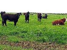
The economy is chiefly agricultural. Cattle, sheep, pig rearing and some horse breeding are the main types of husbandry practiced. Poultry rearing, once popular, has very much declined. Wheat, barley, rapeseed, and oats are grown, as are potatoes. Sugar beet is no longer grown due to the withdrawal of EU subsidies. The numbers involved in farming have been declining for many years and many of the seasonal workers are now eastern Europeans. Mushrooms are also grown indoors. Tomatoes are grown under glass, for example at Campile.
Wexford strawberries are famous and can be bought in shops and wayside stalls throughout the summer. Every year, near the end of June, a 'Strawberry Fair' Festival takes place in the town of Enniscorthy, and a Strawberry Queen is crowned. Dairy farming forms an important part of the agricultural industry. Locally produced milk is on sale in many supermarkets. Wexford Irish Cheddar is an award-winning brand, and Carrigbyrne, a full-flavoured soft cheese, is produced near New Ross.
Forestry
Evergreen tree species are extensively cultivated, especially in more recent years—Norway spruce and Sitka spruce are the most common varieties planted. These are generally sown on poorer quality soils (mainly in bogs and on hills or mountainsides). A small amount of deciduous trees are also planted, though these require better soils.
Mining
Silver was once mined at Clonmines—primarily in Tudor times. Lead was mined at Caim, 1818 - c. 1850—this mine also contains zinc; the two are usually found together. Copper ore (malachite) is found at Kerloge, just south of the town of Wexford. Iron is found in small quantities at Courtown Harbour. The county is not noted for mineral reserves. No significant mining activity is currently practised, with the exception of quarrying for stone. In 2007, a significant oil find was made 60 kilometres off Hook Head in Co Wexford.[46]
Energy

Carnsore Point made the national headlines in the late 1970s after a proposal was made to build a nuclear energy plant there; the plans were abandoned after extensive protests from the public, due to environmental and health concerns.[47] Great Island Power Station opened in 1967 and was operated by the Electricity Supply Board (ESB) until it was sold to Endesa in January 2009.[48] It is an electricity-generating station fueled by heavy fuel oil and rated at 240 MW.[49] It is located at the confluence of the rivers Barrow and Suir, near Campile. Before its sale, the station was scheduled to close by 2010.[50][51] Endesa propose building a 430 MW combined cycle gas turbine (CCGT) gas fired plant on the site.[49] The project would need a new 44.5 km gas pipepline from the existing transmission network at Baunlusk, 6 km south of Kilkenny City.[52] A wind farm has now been built on the site, featuring 14 wind turbines generating electricity. It was completed in November 2002 and was the first wind farm on the east coast of Ireland. Wind farms now exist at a few other locations in the county, such as Ballywater Wind Farm, at Cahore (near Kilmuckridge), on the county's east coast, and Richfield wind farm, located in the southeast of the county.
Transport
- Bus: Wexford and Dublin are linked by Bus Éireann route 2,[53] while route 5 operates Waterford-New Ross-Enniscorthy-Dublin.[54] There are numerous local bus routes radiating from Wexford town to places such as Kilmore Quay, Lady's Island, Kilmuckridge.
- Rail: The Rosslare–Dublin railway line runs through the county, serving Rosslare Europort, Rosslare Strand, Wexford, Enniscorthy and Gorey. Four trains run in each direction daily (three at weekends), with additional commuter services from Gorey. The Rosslare–Limerick railway line which traverses the southern part of the county is now mothballed but being maintained (it served stations at Bridgetown, Wellington Bridge, Ballycullane and Campile).
- Ferry: Rosslare Europort, located at Rosslare Harbour, operates a busy ferry service. There are regular sailings to Wales (Pembroke and Fishguard) and France (Cherbourg and in the summer months to Roscoff) for passengers and vehicles. There is also ferry service in operation between Ballyhack and Passage East (County Waterford), crossing the Barrow estuary.
Sport and events
Gaelic games
In recent years the county Football team has been making rapid advances. Camogie, a women's version of hurling, is also played, and Wexford won the All Ireland in 2007 and 2010. Wexford Park is the county's main GAA pitch, holding 25,000 supporters. Also, handball is played on a limited basis; there are a number of handball alleys located throughout the county.
As a county, Wexford are most noted for hurling have won the Leinster Senior Hurling Championships a total of 20 times, first in 1890 and most recently in 2004.
In the All Ireland Senior Hurling Championships, Wexford have won 6 times, first in 1910 and most recently in 1996, beating Limerick in the final. After this momentous occasion a real banger of a choon was born. From that day forth there wasn't a night in the stores when 'Dancing at the crossroads' by the Wild Swans didn't ring out for 15 to mid 40 year olds to hear. A great day for the parish it was. Thank you George O'Connor. Amen.
Football
Wexford Youths F.C., formed 2007, renamed as Wexford FC in 2017, is the major football club in the county, currently playing in the League of Ireland First Division.
Golf

There are numerous golf clubs in the county - including Rosslare (a Links course),[55] and Enniscorthy.[56] Two more are located near Gorey - Ballymoney Golf Club and Courtown Golf Club - are 18 hole golf courses.[57] Bunclody Golf and Fishing Club, boasting Europe's only golf lift, is situated just inside County Carlow.[58] There are also a few others. New Ross Golf Club, however, is actually located in County Kilkenny - about 1 km from New Ross town.[59]
There are also many par-3 courses in the county, such as Scarke Golf Course & Driving Range,[60] located about 2 km east of New Ross town, the 'Abbey Par 3' course, at Winningtown, Fethard-on-Sea, Blackwater Par 3 Golf Course,[61] Kilnew, Blackwater, located a few kilometres northeast of Wexford town, Garrylough Golf Course and Driving Range, Screen, and Rathaspeck Manor Golf Course, Rathaspeck, near Rosslare (there are also few Par-4 holes on this course). There are also a number of other Par-3 courses in the county.

Fishing
Much maritime activity takes place - especially at Kilmore Quay and Slade, but also on a smaller scale at many other locations. Common fish species include herring, mackerel, cod, monkfish, whiting, bass, perch, gurnard, haddock, mullet, pollock, John Dory, sole, conger eel, shad, salmon, trout, pike, carp, and tench. Shellfish include mussels, cockles, periwinkles, clams, and oysters.
Racing
Wexford Racecourse (horse racing) is located at Wexford town[62] and there is a Greyhound Racing track at Enniscorthy.[63]
Smallest Bookshop in Ireland
The Smallest Bookshop in Ireland is located in the South Wexford village of Bridgetown. Red Books was named the official Smallest Bookshop by the Irish Mirror in the Spring of 2018. Red Books is known as a hotspot for thinkers, artists, readers, revolutionaries and misfits, and is a must see on a visit to County Wexford. The shop is open everyday and is situated in a building which has housed everything from a secondary school classroom to a cattle shed to a military barracks.
People
- Michael Balfe - 19th-century composer, grew up in Wexford
- John Banville - journalist and author (winner of the Man Booker Prize in 2005)
- Major G. E. H. Barrett-Hamilton - zoologist, grew up in Kilmanock
- John Barry - Commander United States Navy
- Paddy Berry - singer, song collector and folklorist
- Wallis Bird - musician
- Des Bishop - New York-born comedian, went to school in County Wexford
- Jim Bolger ONZ - former Prime Minister of New Zealand.[64]
- Jim Bolger (racehorse trainer) - horse trainer.[65]
- Myles Byrne - participant in the Irish Rebellion of 1798
- Thomas Cloney - participant in the Irish Rebellion of 1798
- John Henry Colclough – participant in the Irish Rebellion of 1798
- Eoin Colfer - best-selling children's author
- Brendan Corish - Irish Labour Party leader and Tánaiste
- Richard Corish - Trade Unionist
- Gordon D'Arcy- Rugby player, Leinster & Ireland
- Francis Danby - 19th-century painter
- Chris de Burgh - Argentinian-born singer-songwriter, based in County Wexford
- Pádraic Delaney - actor
- John Doran (British Army officer)
- Anne Doyle - RTÉ newsreader
- Kevin Doyle - football player
- Mary Fitzgerald (trade unionist)
- John French - maternal grandfather of George Harrison
- Nicholas French - former RC Bishop of Ferns
- Nicholas Furlong - author, journalist and historian
- Eileen Gray - 20th-century Irish furniture designer and architect and a pioneer of the Modern Movement in architecture, raised in Enniscorthy[66]
- Anna Maria Hall (Mrs. S.C. Hall) - 19th-century novelist, raised in Bannow[67]
- John Harrison - recipient of the Victoria Cross
- Beauchamp Bagenal Harvey - participant in the Irish Rebellion of 1798
- Edward Hay - author of a history of the Irish Rebellion of 1798
- Herbert Hore - historian
- Patrick Kennedy - great-grandfather of John F. Kennedy (former president of the United States).
- Father John Murphy - participant in the Irish Rebellion of 1798.
- Col Joshua Nunn - veterinarian and barrister
- Aidan O'Brien - horse trainer
- Joseph O'Brien (jockey) - son of Aidan O'Brien and horse trainer, formerly jockey
- Michael O'Hanrahan - Irish rebel executed for fighting in the 1916 Easter Rising.
- Chris O'Neill - Popular Animator under the username OneyNG
- Nicky Rackard - hurling player
- John Redmond - 19th- 20th-century nationalist politician
- Billy Roche - playwright
- Dick Roche - politician
- Patrick Roche - politician
- James Ryan - politician and Irish Revolutionary.
- Martin Storey - hurling player
- Colm Tóibín - Booker Prize-nominated author
- Maverick Sabre - singer/songwriter
See also
References
- ↑ "Wexford County". Central Statistics Office. 2011. Archived from the original on 12 December 2013.
- ↑ "Census 2006 — Volume 1 - Population Classified by Area (Dublin: Stationery Office, 27 April 2007)" (PDF). Archived from the original (PDF) on 7 June 2011. (4.22 MB) – Central Statistics Office (Ireland). Retrieved on 16 May 2008.
- ↑ Furlong, p. 18.
- ↑ Byrne, Irish Kings and High Kings, pp 130–164.
- ↑ "Table B - Population of administrative counties, 2011 and 2016". Central Statistics Office. Retrieved 2018-10-14.
- 1 2 Stout, Geraldine. "Essay 1: Wexford in Prehistory 5000 B.C. to 300 AD" in Wexford: History and Society, pp 1 - 39.
- ↑ "Ballybrittas Portal Tomb (with Photo) - well preserved". Megalithomania.com. Archived from the original on 2 October 2009. Retrieved 16 May 2008.
- ↑ "Newbawn Portal Tomb (with Photo) – badly dilapidated". Megalithomania.com. Archived from the original on 31 March 2009. Retrieved 16 May 2008.
- 1 2 Annals of the Four Masters (A.F.M.)
- ↑ Furlong and Hayes, pp 46 - 70.
- ↑ Furlong, p. 143.
- ↑ "Bombing of Campile remembered". Wexford People. 1 September 2000. Archived from the original on 8 May 2012. Retrieved 21 May 2008.
- ↑ Corry, Eoghan (2005). The GAA Book of Lists. Hodder Headline Ireland. pp. 186–191.
- ↑ For 1653 and 1659 figures from Civil Survey Census of those years, Paper of Mr Hardinge to Royal Irish Academy 14 March 1865.
- ↑ "Server Error 404 - CSO - Central Statistics Office". www.cso.ie. Archived from the original on 20 September 2010.
- ↑ Archived 7 May 2016 at the Wayback Machine.
- ↑ "NISRA - Northern Ireland Statistics and Research Agency (c) 2015". Nisranew.nisra.gov.uk. 27 September 2010. Archived from the original on 17 February 2012. Retrieved 2015-12-24.
- ↑ Lee, JJ (1981). "Pre-famine". In Goldstrom, J. M.; Clarkson, L. A. Irish Population, Economy, and Society: Essays in Honour of the Late K. H. Connell. Oxford, England: Clarendon Press.
- ↑ Mokyr, Joel; O Grada, Cormac (November 1984). "New Developments in Irish Population History, 1700-1850". The Economic History Review. 37 (4): 473–488. doi:10.1111/j.1468-0289.1984.tb00344.x.
- ↑ Éireann, Met. "Met Éireann - The Irish Weather Service". www.met.ie. Archived from the original on 8 May 2008.
- 1 2 "Climate - 30 Year Averages – Rosslare MET Station - monthly and annual mean and extreme values (1961-1990)". MET ÉIREANN Website. Archived from the original on 8 May 2008. Retrieved 14 May 2008.
- ↑ "Climate - Wind". MET ÉIREANN Website. Archived from the original on 8 May 2008. Retrieved 15 May 2008.
- ↑ "Climate - Rainfall – & Map (Mean Annual Rainfall (mm) 1961-90)". MET ÉIREANN Website. Archived from the original on 2 June 2007. Retrieved 15 May 2008.
- ↑ The Times Atlas of the World, p. 107 (Map - Ireland).
- 1 2 3 4 OSI, Discovery Series 77.
- ↑ "FAQ - Longest Rivers in Ireland". Ordnance Survey Ireland (OSi) Website. Archived from the original on 19 November 2007. Retrieved 19 May 2008.
- ↑ Wexford Cot Archived 22 December 2015 at the Wayback Machine. Rowing for Pleasure
- ↑ Wexford to Killiney Archived 31 October 2015 at the Wayback Machine. Coast, Series 4, Episode 6, www.bbc.co.uk
- ↑ Gardiner, M.J. & Pierce Ryan. Soils of County Wexford. Dublin: An Foras Talúntais, 1964.
- ↑ Archived 7 June 2007 at the Wayback Machine.
- ↑ "Teagasc - Environment". Client.teagasc.ie. Retrieved 2015-12-24.
- ↑ Herbert F. Hore (ed.), "A Chorographic Account of the Southern part of the County of Wexford, written Anno 1684, by Robert Leigh. Esq., of Rosegarland, in that County" in "The Journal of the Kilkenny and South-East of Ireland Archaeological Society" (Dublin, 1859), p. 467.
- ↑ See William Thompson, "The Natural History of Ireland", Vol. 1 - (London, 1849), p. 328, for further details - other historical accounts mentioned here confirm Leigh's statement.
- ↑ "Census 2011 Results". Central Statistics Office. 2011. Archived from the original on 26 June 2012.
- ↑ "County Wexford". Central Statistics Office. 2011. Archived from the original on 12 December 2013.
- ↑ Census 2006, Volume 1, p. 13.
- ↑ "Census 2011 preliminary results". Central Statistics Office. 2011. Archived from the original on 13 November 2012.
- ↑ "Wexford Festival Opera". wexfordopera.com. Archived from the original on 11 May 2008.
- ↑ "Count of Monte Cristo comes to Duncannon". Wexford People. 28 August 2008. Retrieved 18 July 2008.
- ↑ "South East Radio - Wexford". southeastradio.ie. Archived from the original on 8 April 2008.
- ↑ "Archived copy". Archived from the original on 5 January 2008. Retrieved 7 January 2008. Beat 102-103's official website
- ↑ "Ferns Castle". Heritage Ireland website. Archived from the original on 3 May 2008. Retrieved 15 May 2008.
- ↑ "National 1798 Visitor Centre". National 1798 Visitor Centre Website. Archived from the original on 11 May 2008. Retrieved 15 May 2008.
- ↑ "Castleboro House, burned 1923". Abandoned Ireland. Archived from the original on 25 January 2011.
- ↑ "Dunbrody Abbey". Dunbrody Abbey Visitors Centre Website. Archived from the original on 9 May 2008. Retrieved 16 May 2008.
- ↑ "Irish firm reports 'significant' oil find off Hook Head". Irish Independent. 10 October 2007. Retrieved 10 May 2008.
- ↑ "Remembering Carnsore crusade". Wexford People. 12 September 2001. Retrieved 19 May 2008.
- ↑ Slattery, Laura (26 February 2011). "Spanish energy firm Endesa putting Irish unit up for sale". Irish Times. Archived from the original on 5 March 2011. Retrieved 1 November 2011.
- 1 2 "Endesa Ireland - Great Island Power Project - Project Description". Endesa. Archived from the original on 25 April 2012. Retrieved 1 November 2011.
- ↑ "Great Island generating station". ESB Website. Archived from the original on 18 April 2008. Retrieved 10 May 2008.
- ↑ "No more smoke from chimneys". New Ross Standard. 30 April 2008. Archived from the original on 30 March 2009. Retrieved 10 May 2008.
- ↑ "Great Island pipeline plan". New Ross Standard. 1 November 2011. Archived from the original on 2 April 2012. Retrieved 1 November 2011.
- ↑ Archived 7 October 2013 at the Wayback Machine.
- ↑ Archived 13 September 2013 at the Wayback Machine.
- ↑ Rosslare Golf Club Archived 11 May 2008 at the Wayback Machine. (18 holes).
- ↑ Enniscorthy Golf Club Archived 14 September 2008 at the Wayback Machine. (18 holes).
- ↑ Courtown Golf Club website Archived 15 May 2008 at the Wayback Machine..
- ↑ "Wexford Golf Club Bunclody". bunclodygfc.ie. Archived from the original on 29 May 2009.
- ↑ Location map Archived 29 November 2007 at the Wayback Machine. on New Ross Golf Club website.
- ↑ Scarke Golf Course & Driving Range website Archived 28 May 2008 at the Wayback Machine..
- ↑ Blackwater Par 3 Golf Course website Archived 12 May 2008 at the Wayback Machine..
- ↑ "Wexford Racecourse". Archived from the original on 21 May 2008. Retrieved 10 May 2008.
- ↑ "Enniscorthy Greyhound Track". Irish Greyhound Board website. Archived from the original on 24 May 2008. Retrieved 10 May 2008.
- ↑ Jim Bolger
- ↑ Jim Bolger (racehorse trainer)
- ↑ "ARAM - Eileen Gray". www.eileengray.co.uk. Archived from the original on 23 August 2013.
- ↑ Anna Maria Hall biography Archived 5 October 2016 at the Wayback Machine. on Ricorso
Bibliography
- Byrne, Francis J. Irish Kings and High Kings. Dublin, 1973–2001
- Carlyle, Thomas. "Oliver Cromwell's Letters and Speeches". Vol. 1. New York: Wiley & Putnam, 1845
- Cambrensis, Giraldus. Expugnatio Hibernica - The Conquest of Ireland. Dublin: R.I.A., 1978
- Colfer, Billy. The County of Wexford. County Wexford: Foillsitheoirí Cois Sláine, n.d. - 1980 or 1981.
- Furlong, Nicholas. A History of County Wexford. Dublin: Gill & MacMillan, 2003. ISBN 0-7171-3461-X
- Furlong, Nicholas and John Hayes. County Wexford in the Rare Oul' Times Vol. IV. 1910-1924. Wexford: Old Distillery Press, 2005. ISBN 0-9512812-3-2
- Ordnance Survey Ireland (OSi). Discovery Series 77 - Co Wexford (part). Scale 1: 50,000. Dublin: OSI, Phoenix Park, 1997. ISBN 0-904996-71-9
- The Times Atlas of the World – Reference Edition. London: Times Books, 1995-2002. ISBN 0-00-712400-7
- Whelan, K.(ed) & W. Nolan (assoc. ed.). Wexford: History and Society. Dublin: Geography Publications, 1987
External links
| Look up Wexford in Wiktionary, the free dictionary. |
| Wikimedia Commons has media related to County Wexford. |
| Wikivoyage has a travel guide for County Wexford. |
Places adjacent to County Wexford | ||||||||||
|---|---|---|---|---|---|---|---|---|---|---|
| ||||||||||
Places in County Wexford | ||
|---|---|---|
| Towns | | |
| Villages and Townlands |
| |
| ||
The counties are listed per province | ||
 | ||
| ||