County Carlow
| County Carlow Contae Cheatharlach | |||
|---|---|---|---|
| |||
 | |||
| Country | Ireland | ||
| Province | Leinster | ||
| Dáil Éireann | Carlow–Kilkenny | ||
| EU Parliament | South | ||
| County town | Carlow | ||
| Government | |||
| • Type | County Council | ||
| Area | |||
| • Total | 897 km2 (346 sq mi) | ||
| Area rank | 31st | ||
| Population (2016)[1] | 56,875 | ||
| • Rank | 30th | ||
| Vehicle index mark code | CW | ||
| Website |
www | ||

| Historical population | ||
|---|---|---|
| Year | Pop. | ±% |
| 1653 | 4,969 | — |
| 1659 | 5,434 | +9.4% |
| 1821 | 78,952 | +1352.9% |
| 1831 | 81,988 | +3.8% |
| 1841 | 86,228 | +5.2% |
| 1851 | 68,078 | −21.0% |
| 1861 | 57,137 | −16.1% |
| 1871 | 51,650 | −9.6% |
| 1881 | 46,568 | −9.8% |
| 1891 | 40,936 | −12.1% |
| 1901 | 37,748 | −7.8% |
| 1911 | 36,252 | −4.0% |
| 1926 | 34,476 | −4.9% |
| 1936 | 34,452 | −0.1% |
| 1946 | 34,081 | −1.1% |
| 1951 | 34,162 | +0.2% |
| 1956 | 33,888 | −0.8% |
| 1961 | 33,342 | −1.6% |
| 1966 | 33,593 | +0.8% |
| 1971 | 34,237 | +1.9% |
| 1979 | 38,668 | +12.9% |
| 1981 | 39,820 | +3.0% |
| 1986 | 40,988 | +2.9% |
| 1991 | 40,942 | −0.1% |
| 1996 | 41,616 | +1.6% |
| 2002 | 46,014 | +10.6% |
| 2006 | 50,349 | +9.4% |
| 2011 | 54,612 | +8.5% |
| 2016 | 56,875 | +4.1% |
| [2][3][4][5][6][7] | ||
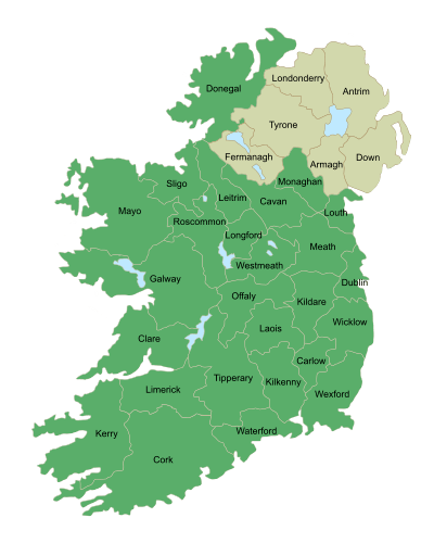
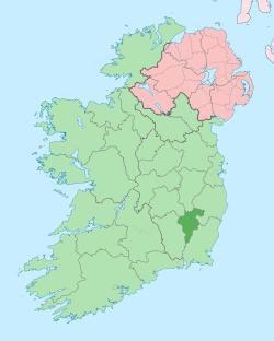
County Carlow (Irish: Contae Cheatharlach) is a county in Ireland, part of the South-East Region and the province of Leinster.[8] It is named after the town of Carlow, which lies on the River Barrow. Carlow County Council is the local authority. The population was 56,875 at the 2016 census.[9]
Geography and political subdivisions
Carlow, or "Ceatharlach" originally part of the Norman Palantine-county of Leinster, became a separate county probably around 1306.[10] At that time it was larger than today, extending to and including the coastal area around Arklow, though control of this area became disputed with the Irish chieftains of the area. These areas were given over to County Wicklow in 1606-07.
Baronies
There are seven historic baronies in the county: Carlow, Forth, Idrone East, Idrone West, Rathvilly, St Mullin's Lower and St Mullin's Upper.
Towns and villages
Local government and politics
Local government in County Carlow is governed by the Local Government Acts, the most recent of which (Local Government Act 2001) established a two-tier structure of local government. The top tier of the structure consists of Carlow County Council. The second tier of local government consists of town councils. Outside the borough, the county council is solely responsible for local services.[11] Two towns in the county have town councils: Carlow and Muine Bheag. There are 21 councillors in the county council who are returned from five local electoral areas: Borris (3), Carlow East (4), Carlow West (5), Muine Bheag (4) and Tullow (4).[12][13] As the county is part of the South-East Region, some county councillors are also representatives on the South-East Regional Authority.
For elections to Dáil Éireann, Carlow is part of the Carlow–Kilkenny constituency which returns 5 TDs. The present form of the constituency was created for the 1948 general election.
Sport
- F.C. Carlow are the local soccer team who compete in the A Championship
- Carlow GAA are the county's Gaelic Athletic Association body which fields both hurling and football teams.
People
- Pierce Butler - soldier, planter, and statesman, recognized as one of United States' Founding Fathers. He represented South Carolina in the Continental Congress and the United States Senate.
- Myles Keogh - American Civil War military officer and later Captain of Company I, U.S. 7th Cavalry Regiment - Fought in Indian Wars and was killed at the Battle of the Little Bighorn in 1876. He was born in Orchard, Leighlinbridge in 1840.
- William Dargan - engineer, often seen as the father of Irish railways.
- Richie Kavanagh - comic songwriter, from Raheenwood, Fenagh, Co. Carlow.
- John Tyndall - the 19th century scientist who was the first to explain why the sky is blue.
- Derek Ryan - Country music singer & former member of Pop band D-side
- Saoirse Ronan - Oscar nominated and Golden Globe awarded actress.
- Kathryn Thomas - RTÉ presenter.
- Samuel Haughton - polymath, in 1866 published a formula for calculating the drop needed to cause instantaneous death at hangings.
- Peter Murphy - radio and television broadcaster, presented RTÉ's Cross Country Quiz, was born in Carlow
- Sean O'Brien - Leinster and Ireland international rugby player.
- Frank O'Meara - Carlow-born Irish artist known for his Impressionist, plein air landscape painting (1853-1888).
- James Fenelon - member of the Wisconsin State Assembly.
- David Mullins - Irish jockey, notable for riding Rule The World to win the 2016 Grand National
- Mary O'Toole - first woman municipal judge in the United States
See also
References
- ↑ "County Carlow". Central Statistics Office. 2011.
- ↑ For 1653 and 1659 figures from Civil Survey Census of those years, Paper of Mr Hardinge to Royal Irish Academy 14 March 1865.
- ↑ Census for post 1821 figures.
- ↑ http://www.histpop.org Archived 7 May 2016 at the Wayback Machine.
- ↑ "Archived copy". Archived from the original on 17 February 2012. Retrieved 2010-08-12.
- ↑ Lee, JJ (1981). "Pre-famine". In Goldstrom, J. M.; Clarkson, L. A. Irish Population, Economy, and Society: Essays in Honour of the Late K. H. Connell. Oxford, England: Clarendon Press.
- ↑ Mokyr, Joel; O Grada, Cormac (November 1984). "New Developments in Irish Population History, 1700-1850". The Economic History Review. 37 (4): 473–488. doi:10.1111/j.1468-0289.1984.tb00344.x.
- ↑

- ↑ "Table B - Population of administrative counties, 2011 and 2016". Central Statistics Office. Retrieved 2018-10-14.
- ↑ Desmond Roche, Local Government in Ireland, Dublin, 1982
- ↑ "All Services". Carlow County Council. Retrieved 27 March 2011.
- ↑ "2009 Local elections – Carlow County Council". ElectionsIreland.org. Retrieved 27 March 2011.
- ↑ Act of the Oireachtas: County of Carlow Local Electoral Areas Order 2008
External links
| Wikimedia Commons has media related to County Carlow. |
| Wikisource has the text of the 1911 Encyclopædia Britannica article Carlow (county). |
| Wikivoyage has a travel guide for County Carlow. |
Places in County Carlow | ||
|---|---|---|
| Towns | | |
| Villages and townlands | ||
| ||