Circular Head Council
| Circular Head Council Tasmania | |||||||||||||||
|---|---|---|---|---|---|---|---|---|---|---|---|---|---|---|---|
|
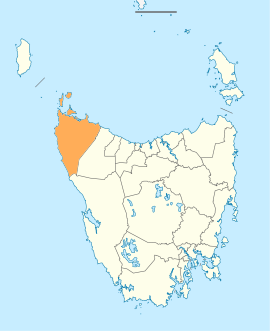
Map showing the Circular Head local government area. | |||||||||||||||
| Coordinates | 41°04′02″S 145°00′44″E / 41.0673°S 145.0122°ECoordinates: 41°04′02″S 145°00′44″E / 41.0673°S 145.0122°E | ||||||||||||||
| Population | 7,926 (2016 census)[1] | ||||||||||||||
| • Density | 1.6/km2 (4.1/sq mi) | ||||||||||||||
| Established | 1 January 1907[2] | ||||||||||||||
| Area | 4,917 km2 (1,898.5 sq mi) | ||||||||||||||
| Mayor | Daryl Quilliam | ||||||||||||||
| Council seat | Smithton | ||||||||||||||
| Region | Smithton and Stanley area | ||||||||||||||
| State electorate(s) | Braddon | ||||||||||||||
| Federal Division(s) | Braddon | ||||||||||||||
|
| |||||||||||||||
| Website | Circular Head Council | ||||||||||||||
| |||||||||||||||
Circular Head Council is a local government body in Tasmania, covering the far north-west of the state mainland. Circular Head is classified as a rural local government area and has a population of 7,926, major towns and localities of the region include Arthur River, Marrawah and Stanley with Smithton the largest principal town.
History and attributes
Circular Head was established on 1 January 1907, the boundaries were altered in 1993 as part of a reorganisation.[2] The region includes the smaller islands immediately off the north-west tip of the state including Robbins Island, Hunter Island and Three Hummock Island.
Circular Head is classified as rural, agricultural and large (RAL) under the Australian Classification of Local Governments.[3]
Government
| Name | Position[4] | Party affiliation | |
|---|---|---|---|
| Daryl Quilliam | Mayor/Councillor | Independent | |
| Jan Bishop | Deputy Mayor/Councillor | Independent | |
| Norman Berechree | Councillor | Independent | |
| Betty Kay | Councillor | Independent | |
| John Oldaker | Councillor | Independent | |
| Ashley Popowski | Councillor | Independent | |
| Nakore Popowski | Councillor | Independent | |
| Trevor Spinks | Councillor | Independent | |
| David Woodward | Councillor | Independent | |
Localities
| Locality | Population (2011 census)[5] | Reason |
|---|---|---|
| Woolnorth | Incl. in Arthur River | |
| West Montagu | Incl. in Montagu | |
| Montagu | 327 | Includes West Montagu, Broadmeadows, Mella, Sorpus |
| Sorpus | Incl. in Montagu | |
| Hunter Island | Incl. in Arthur River | |
| Three Hummock Island | Incl. in Arthur River | |
| Trefoil Island | Incl. in Arthur River | |
| Walker Island | Incl. in Arthur River | |
| Robbins Island | Incl. in Arthur River | |
| Kangaroo Island | Incl. in Arthur River | |
| Perkins Island | Incl. in Arthur River | |
| Mella | Incl. in Montagu | |
| Smithton | 3,935 | |
| Broadmeadows | Incl. in Montagu | |
| Stanley | 481 | |
| Wiltshire | Incl. in Forest | |
| Black River | Incl. in Mawbanna | |
| Cowrie Point | Incl. in Mawbanna | |
| Port Latta | Incl. in Mawbanna | |
| Crayfish Creek | Incl. in Hellyer | |
| Edgcumbe Beach | Incl. in Hellyer | |
| Rocky Cape | 216 | |
| Montumana | Incl. in Mawbanna | |
| Mawbanna | 208 | Includes Montumana, Port Latta, Cowrtie Point, Black River |
| Forest | 590 | Includes Wiltshire |
| South Forest | Incl. in Mengha | |
| Mengha | 300 | Includes South Forest, Alcombie |
| Scotchtown | 303 | Includes Edith Creek |
| Irishtown | 287 | |
| Alcombie | Incl. in Mengha | |
| Lileah | Incl. in Trowutta | |
| Nabageena | Incl. in Trowutta | |
| Edith Creek | Incl. in Scotchtown | |
| Roger River | Incl. in Trowutta | |
| Detention | Incl. in Rocky Cape | |
| Hellyer | 302 | Includes Crayfish Creek, Edgcumbe Beach |
| Westcoast | 13 | Includes Temma |
| Christmas Hills | Incl. in Redpa | |
| Brittons Swamp | Incl. in Redpa | |
| Togari | Incl. in Redpa | |
| Redpa | 343 | Includes Togari, Brittons Swamp, Christmas Hills |
| Marrawah | Incl. in Arthur River | |
| Arthur River | 371 | Includes Wooolnorth, Hunter Island, Three Hammock Island, Trefoil Island, Walker Island, Robbins Island, Kangaroo Island, Marrawah, Nelson Bay |
| Nelson Bay | Incl. in Arthur River | |
| Temma | Incl. in Westcoast | |
| Trowutta | 297 | Includes Lileah, Nabageena, Roger River |
| Total | 7,973 | |
| 4 | Variance | |
| Local government total | 7,977 | Gazetted Central Coast Local Government Area |
See also
References
- ↑ Australian Bureau of Statistics (27 June 2017). "Circular Head (M)". 2016 Census QuickStats. Retrieved 23 November 2017.

- 1 2 "Agency Details: Circular Head". search.archives.tas.gov.au. Tasmanian Government. Retrieved 11 June 2018.
- ↑ "Local government national report 2014-2015". regional.gov.au. Australian Government. Retrieved 8 June 2018.
- ↑ "Councillors - Circular Head Council". circularhead.tas.gov.au/. Circular Head Council. Retrieved 6 May 2016.
- ↑ Australian Bureau of Statistics. "2011 Census QuickStats". Retrieved 9 April 2016.
External links
- Circular Head Council official website
- Local Government Association Tasmania
- Tasmanian Electoral Commission - local government
This article is issued from
Wikipedia.
The text is licensed under Creative Commons - Attribution - Sharealike.
Additional terms may apply for the media files.