Stanley, Tasmania
| Stanley Tasmania | |||||||||
|---|---|---|---|---|---|---|---|---|---|
 Stanley and The Nut viewed from Highfield | |||||||||
 Stanley | |||||||||
| Coordinates | 40°46′S 145°18′E / 40.767°S 145.300°ECoordinates: 40°46′S 145°18′E / 40.767°S 145.300°E | ||||||||
| Population | 481 (2011 census)[1] | ||||||||
| Postcode(s) | 7331 | ||||||||
| Elevation | 10 m (33 ft)[2] | ||||||||
| Location |
| ||||||||
| LGA(s) | Circular Head Council | ||||||||
| State electorate(s) | Braddon | ||||||||
| Federal Division(s) | Braddon | ||||||||
| |||||||||
Stanley is a town on the north-west coast of Tasmania, Australia. Travelling west, Stanley is the second-last major township on the north-west coast of Tasmania, Smithton being the larger township in the Circular Head municipality.
According to the 2011 census, Stanley had a population of 481.[1]
History
In 1825 the Van Diemen's Land Company was granted land in north-western Van Diemen's Land, including the Stanley area. Employees of the company from England settled in the area in October 1826.[3]
The site (originally called Circular Head) was named after Lord Stanley, the British Secretary of State for War and the Colonies in the 1830s and 1840s, who later had three terms of office as British Prime Minister.
A port opened in 1827 and the first school opened in 1841. There was a short-lived bay whaling station in operation on the fore-shore in the 1830s.[4] Stanley officially became a town in 1842 and by 1843 more than 8,000 acres had been sold or leased to almost 70 people. [5]
The Post Office opened on 1 July 1845 and was known as Circular Head post office until 1882. [6] In 1880 the first coach service between Stanley and Burnie was established.
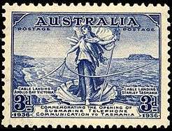
In 1936 a submarine telephone cable from Apollo Bay to Stanley provided the first telephone to Tasmania from the mainland.
The town today
Today Stanley is a tourist destination and the main fishing port on the north-west coast of Tasmania.
The most distinctive landmark in Stanley is Munatrik[7], commonly called The Nut, an old volcanic plug. Bass and Flinders sighted it on their circumnavigation of Van Diemen's Land (now called Tasmania) in 1798 and named it Circular Head. It has steep sides and rises to 143 metres with a flat top. It is possible to walk to the top of The Nut via a steep track or via a chairlift.
Tourists regularly travel to Highfield (a farming region on the north west of the township) to view the picturesque northern beaches with The Nut in the background.
The port on the southern side of The Nut is also a regularly used fishing spot.
Notable people from Stanley
- Joseph Lyons – The tenth Prime Minister of Australia.[3]
- Jim Willis – Australian botanist
- Bill Mollison – Founder of the Permaculture movement
- John Lee Archer - the "Father of Tasmanian architecture". Archer became a magistrate in the Circular Head area in 1838 until his death in 1852. [8] He produced an official a map of Stanley in 1843, reproduced by Betty Jones (2015). [9]
Climate
Stanley has a warm-summer mediterranean climate that is transitional with the oceanic climate (Köppen climate classification csb/cfb). Its summers are moderated by its shoreline position, whereas the rainy winters have moderate lows.
| Climate data for Stanley | |||||||||||||
|---|---|---|---|---|---|---|---|---|---|---|---|---|---|
| Month | Jan | Feb | Mar | Apr | May | Jun | Jul | Aug | Sep | Oct | Nov | Dec | Year |
| Average high °C (°F) | 21.2 (70.2) |
21.5 (70.7) |
20.0 (68) |
17.4 (63.3) |
15.1 (59.2) |
13.3 (55.9) |
12.6 (54.7) |
13.2 (55.8) |
14.2 (57.6) |
16.0 (60.8) |
17.7 (63.9) |
19.4 (66.9) |
16.8 (62.2) |
| Average low °C (°F) | 10.9 (51.6) |
11.4 (52.5) |
9.4 (48.9) |
7.0 (44.6) |
5.3 (41.5) |
4.1 (39.4) |
3.4 (38.1) |
3.9 (39) |
4.9 (40.8) |
6.1 (43) |
7.9 (46.2) |
9.5 (49.1) |
7.0 (44.6) |
| Average precipitation mm (inches) | 40.7 (1.602) |
47.9 (1.886) |
44.1 (1.736) |
74.1 (2.917) |
99.2 (3.906) |
111.1 (4.374) |
132.7 (5.224) |
108.8 (4.283) |
94.5 (3.72) |
98.3 (3.87) |
74.4 (2.929) |
64.3 (2.531) |
991.4 (39.031) |
References
- 1 2 Australian Bureau of Statistics (31 October 2012). "Stanley (State Suburb)". 2011 Census QuickStats. Retrieved 3 November 2015.

- ↑ "Climate statistics for Australian locations, Summary statistics STANLEY POST OFFICE". Bureau of Meteorology. Retrieved 3 November 2015.
- 1 2 "Stanley, Tasmania". Australian Places. Monash University. Archived from the original on 2005-03-06.
- ↑ Evans, Kathryn (1993). Shore-based whaling in Tasmania historical research project: Volume 2; site histories (First ed.). Hobart: Parks & Wildlife Service. p. 70-1 & fig 29 map.
- ↑ Jones, E 2015, Along the terrace: the owners and occupiers of Stanley 1843–1922, Stanley Discovery Museum, Stanley, Tasmania, p. vii
- ↑ Premier Postal History. "Post Office List". Retrieved 2008-04-11.
- ↑ "palawa kani place names on the way to Kings Run Handover 2017". palawa kani place names on the way to Kings Run Handover 2017. Tasmanian Aboriginal Center. Missing or empty
|url=(help);|access-date=requires|url=(help) - ↑ url= http://greataustraliansecret.com/john-lee-archer-the-man-who-shaped-tasmanias-early-architecture/ retrieved 26 April 2017
- ↑ Jones, E 2015, Along the terrace: the owners and occupiers of Stanley 1843–1922, Stanley Discovery Museum, Stanley, Tasmania, p. x
External links
An early map of Stanley, held at the National Library of Australia:
Archer, John Lee, 1791-1852; Royston & Brown; Van Diemen's Land Company (1843), A map of Stanley on the estate of the Van Diemens Land Company at Circular Head [cartographic material] / John Lee Archer, Civil Engineer Aug.st 1843, Royston & Brown, Litho