Chin State
| Chin State ချင်းပြည်နယ် | ||
|---|---|---|
| State | ||
| Myanma transcription(s) | ||
| • Burmese | hkyang: pranynai | |
| ||
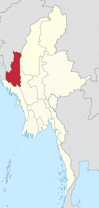 Location of Chin state, Myanmar | ||
| Coordinates: 22°0′N 93°30′E / 22.000°N 93.500°ECoordinates: 22°0′N 93°30′E / 22.000°N 93.500°E | ||
| Country |
| |
| Region | Western Myanmar | |
| Capital | Hakha | |
| Government | ||
| • Chief Minister | Salai Lian Luai (NLD) | |
| • Cabinet | Chin State Government | |
| • Legislature | Chin State Hluttaw | |
| • High Court | Chin State High Court | |
| Area[1] | ||
| • Total | 36,018.8 km2 (13,906.9 sq mi) | |
| Area rank | 9th | |
| Population (2014)[2] | ||
| • Total | 478,801 | |
| • Rank | 14th | |
| • Density | 13/km2 (34/sq mi) | |
| Demographics | ||
| • Ethnicities | Chin | |
| • Religions |
Christianity 85.4% Theravada Buddhism 13% Laipian 1.1% Animism 0.4% Islam 0.1% | |
| Time zone | UTC+06:30 (MST) | |

Chin State (Burmese: ချင်းပြည်နယ်; MLCTS: hkyang: pranynai, pronounced [tɕʰɪ́ɴ pjìnɛ̀]) is a state in western Myanmar. The 36,019-square-kilometre (13,907 sq mi) Chin State is bordered by Sagaing Division and Magway Division to the east, Rakhine State to the south, Bangladesh to the south-west, and the Indian states of Mizoram to the west and Manipur to the north. The population of Chin state is about 478,801 in 2014 census. The capital of the state is Hakha. The state is a mountainous region with few transportation links. Chin State is sparsely populated and remains one of the least developed areas of the country. Chin State has the highest poverty rate of 73% as per the released figures from the first official survey.[3]The official radio broadcasting dialect of Chin is Falam. There are 53 different subtribe and languages in Chin State.
History
Early history
The Chin people entered the Chin Hills in the first millennium AD as part of the wider migration of Chin peoples into the area. For much of history, the sparsely populated Chin Hills were ruled by local chiefs, such as Tlaisun(Hlawncheu), Bawithang, Sumthang and Zahau chiefs in the mid-land (present Falam area), Guite, Thado, Suantak and Sukte chiefs in the north (present Tedim, Tonzang, and Lamka areas), Zathang-Chinzah,Tlangchhan, Khawlhring, and Zokhua chiefs in the south(present Hakha, and Thantlang and some parts of Lushai hill), and Sailo (descendants of Guite or Ninguitea) and Hualngo (descendants of Ngaihte) chiefs in the Lushai hill.The Pakhup and Torel in the Fanai hill. The Chozah, Zawtha, Khule, Hlychho, Topa, Khaimeichho, Kathie, Chhaihlo, Chhachhai, Thlyutha, Zachho, Laihlo, Bohia, Nohro, Hlythi, Notlia,Tau-ei Azyu and Tlapo in the Lakher hills.
Some historians (Arthur Phayre, Tun Nyein) put Pateikkaya in eastern Bengal, thus wrongly placing the entire Chin Hills under Pagan suzerainty but others, like Harvey, citing stone inscriptions, properly put it near the eastern Chin Hills.[4] (Burmese Chronicles report the kings of Pateikkaya as Indian though the ethnicity of the subjects is not explicitly cited.) Accordingly, since the first human settlement in the region later called Chin Hills as early as 10 century CE, no other external military conquest nor tributary influence was noticed either in oral traditions or other historical inscriptions but the rule and leadership of local native chiefs as listed above.
Feudal era
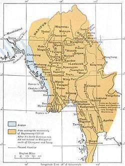
The first confirmed political entity in the region was the Shan State of Kale (Kalay), founded by the Shan people who came to dominate Kale kabaw valley of the northwestern-to-eastern arc of Burma after the fall of the Pagan Kingdom in 1287. Kale was a minor Shan state. Its author. The minor state occasionally paid tribute to the larger Shan States of Mohnyin and Mogaung and ultimately became a vassal state of the Burmese Ava Kingdom in the 1370s. Starting in the 1480s, Ava began to disintegrate and Kale was swallowed up by the Shan State of Mohnyin by the 1520s.
The Burmese kingdoms between 1555 and 1559 when King Bayinnaung of the Toungoo Dynasty conquered part of Upper Burma and its surrounding regions, stretching from the eastern and northern Shan states to the western Maguay division and plain region in Manipur.[5] Toungoo began to weaken in the late 17th century. By the 1730s a resurgent Manipuri Kingdom had conquered the Kabaw Valley, which is at the eastern front of Chin Hills, from the Burmese. Situated in a far west hilly region, however, Chin Hills was traditionally autonomous and far for successional Burman kingdoms to reach. Until British colonial rule, independent city states such as Ciimnuai (Chinwe/Chin Nwe) later shifted to Tedim and Vangteh in the north, Tlaisun and Rallang in the mid-land, and Hakha, Thantlang and Zokhua in the south played important political role in securing peace of the region, and each city states practised its own independent sovereignty in their own rights.
Colonial era
The British acquired the Chin Hills a decade after the Third Anglo-Burmese War of 1885. The ensuing Chin resistance to the British was suppressed only by 1896 with the arrest of Khai Kam Thuantak of Siyin area. The administered the Chin Hills as part of Arakan Division.[6] American missionaries began arriving in the 1890s and, by the middle of the 20th century, most of the Chin people had converted to Christianity.
The region was the westernmost advance of the Imperial Japanese Army, which occupied the region in November 1943, in World War II. After the war, Chin state leaders headed by Vumkhohau Thuantak, with Burman, Shan and Kachin leaders, participated in the Panglong Conference which discussed the future of an independent Union of Burma. Because of the region's heavy economic dependence on Burma, Chin leaders, unlike Shan and Kachin leaders, asked only for a "special administrative division", not a full-fledged state. As a result, when the 1947 Constitution of Burma granted the right of secession to states after 10 years after the independence, the Chin people did not get a state (no right to secede). (The Karen, who did not participate in the conference, received a state, with the right to secede.)
Post Burmese independence
Upon Burma's independence from the United Kingdom in 1948, Chin Hills Special Division was created out of the Chin Hills, with its capital at Falam. On January 4, 1974, it was granted state status and became Chin State.[6] Today, the state has little infrastructure and remains extremely poor and undeveloped.
"Chin National Day" is designated on 20 February to commemorate the "General Assembly of Chinland" held in 1948.[7] The first celebration of Chin National Day was held in 1951. But it was not well recognized by Myanmar governments until the 2010s.[8]
Chin National Front proposed to designate 3 January as "Chin State Day".[9]
Some of the Zomi people, people of the Northern Chin State, quest for their true identity. Then an unsolvable conflict exists between Laimi (Hakha & Thantlang villagers: who called themselves "Chin" though the word "Chin" does not have any meaning in Lai dialect as they do not have this word) and the Zomi (people from Tedim and Tonzang).
There are six main dialectical or ethnical groups in Chin State: 1). Laimi., 2). Zomi., 3). Khumi., 4).mizo., 5). Asho., and 6). Cho.
Administrative divisions
For more easily convince the Chin people within the declaration of emergency rule by the Burma government, Chin State divided of two districts in the north (Hakha District and Falam District) and one in the south (Mindat District) and was further subdivided into nine townships and three sub-townships. Falam had been the district capital since the British colonization. After the military coup in 1962, the junta in the 1974 reorganization shifted the state capital to Hakha.
The township borders have been adjusted, most recently in a reorganization of Falam District in 2008. Falam Township lost area in its northeast to Tedim Township but gained territory from Tedim in the northwest, extending northward as far as the developing town of Rihkhawdar (Reehkawdar) on the Indian border. In that reorganization Falam lost a small area in its southwest back to Thantlang Township from which it had recently been shifted.
Districts and townships
- Falam District of northern Chin State
- Falam Township
- Tedim Township
- Tonzang Township
- Cikha Township
- Rihkhawdar Township
- Hakha District of northern Chin State
- Matupi District
- Matupi Township
- Paletwa Township
- Rezua Township
- Samee Township
- Lailenpi Township
- Mindat District of southern Chin State
Hakha District was formed by the first Chin State Hluttaw emergency meeting No. 2/2012 on 1 June.[10] Matupi District was formed by the second Pyidaungsu Hluttaw regular meeting on 28 June 2017.[11][12]
Cities and towns
- Cikha, sub-township in the north
- Falam, northern Chin State (Falam District)
- Hakha, capital of Chin State (Hakha District)
- Kanpetlet
- Lalenpi, sub-township in west south
- Matupi, southern capital town
- Mindat, southern Chin State
- Paletwa, southern Chin State
- Rezua, Rezua Township
- Rihkhawdar, sub-township in the north
- Sami, sub-township in south
- Tedim, Tedim Township
- Thantlang, Thantlang Township
- Tonzang, Tonzang Township
Government
Legislature
Geography
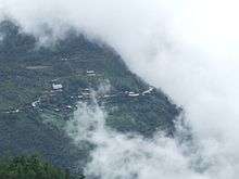
Khonumtung (Mount Victoria), 10,500 feet (3,200 m) high, is the highest peak in Chin State.
Many natural watercourses flow among mountain ranges running from north to south forming valleys and gorges. The state has many rivers and the Meitei Gun flows through its northern half. The Tio River forms much of the border with India for the northern half of the state. The Bawinu/Beino/Chhimtuipui River, as the Kaladan River is known upstream from its confluence with the Tiau, forms the border with India for the central portion of the state. In the southwestern part of the state, the Kaladan River enters from India and flows down past Sinletwa/Salyutlana and Paletwa and exits into Rakhine State. The longest waterfall in Chin state is the Bungtla Waterfall near Matupi.
Population
Demographics
| Historical population | ||
|---|---|---|
| Year | Pop. | ±% |
| 1973 | 323,295 | — |
| 1983 | 368,949 | +14.1% |
| 2014 | 478,801 | +29.8% |
| Source: 2014 Myanmar Census[2] | ||
The Chin people are made up of many tribes which, though historically related, now speak divergent languages and have different cultural and historical identities. Some consider the name Chin an exonym, given by the Burmese and of unclear origin.
The first 'Chin National Day' was celebrated in 1951 at Mindat.
The term Laimi was a common name for the people in Falam, Hakha,Thantlang and Lawngtlai district. There are some western tribes like Lusei, Hmar and Thado are claiming the term Mizo to refer themselves and the whole tribes of the so-called Chins.
The government of Myanmar officially designated Falam as the radio language of Chin State more than 30 years ago. Since then Falam has been the medium for Chin radio program broadcast by the government.
However, the Tedim language is the common language used among Zomi/Zo people. Tedim is spoken widely in Kalay township where they have been vastly overwhelming long before Burmese Independence. The population of Tedim language speaking people is calculated to be more than 100,000, without taking into account of the fact that Ngawn, Vaiphei, Thadou who hardly understand.
Lai is used as main communication languages in Falam, Hakha and Thantlang townships and it is used and understood by most of the chin people. As the dialects in the areas of Hakha and Falam are from Tibeto-Burman dialect and 85% of the phonetic and accent are the same, people from Falam can easily communicate with Hakha language and vice versa. Chin people have a native-like understanding of Mizo language, except for those who live in very remote areas speaking dialects.
Chin people are called by names such as Laimi and Zo people, K'Cho, Lusei (later Mizo), Kuki and others based on the names they were designated by Burmese people in the surrounding areas and the British. Recently, some tidim and tonzang people have accepted Zomi nomenclature, which means the people of Zo (mountain) or Highlanders. This very Zo people who live and dwell in the plain region are called phaimi (which means people from plain area). According to the record of Zam Siian Sang Gualnam who surveyed the seasons and population of the people called Chin Nationalities during the years 2004-2007 with the Chin Survey research team, the combination of all Chin peoples and their populations are as follows:
1. In Sagaing Division
- Tedim Zomi(50000+)
- Zo(25000+)
- Lushai/Lusei/Mizo (50000 +)
- Thadou (50000 +)also called kuki
- Matupi (3000-/+)
- Lai(Hakha-Thlantlang and Zokhua)(40000+)
- Falam(Thuan Khai,Zanniat and Ral Thang (60000+)
- Sizaang(10000+)
- Hawthai (1000+)
- others(50000+)
in MagweDivision
- Lai(Hakha) (20000+)
- Asho(250000+)They łive in lower *magwe and also in Pegu Division.
Others(60000+) Chin of Myanmar in Other Countries
- India(100000+)
- Malaysia(60000+)
- Singapore(3000+)
- Uk/USA/EU(100000+)
2. In Chin State
- numbered 470,000 in population.
3. In India (Census of India 2011)
- Lushai/Mizo (7500000+)
- Thadou-Kuki (280,000 +)
- Hmar (100,000+)
- Mara (90,000+)
- Paite (75000+)Manipur+Mizoram
- Vaiphei (40000+)
- Simte (8,000+)
- Tedim Zomi (40000+)
- Lai(Hakha)(70000 natives+30000)
- Kom (5,000+)
- Zo (22,000+)
Gangte people(20000+) Halam Pople(50000+) They live in Tripura and Assam
Except for Laimi, Thadou,Kuki, Mizo and Hmar, Mara the remaining tribes in India mentioned above are united under Zomi Council. They are Paite, Simte, Vaiphei, Zou, Komrem, Mate and Tedim people. Furthermore, the tribes under Zomi Council and Thadou people speak different dialects that are close to those of the Tedim people. They migrated to Manipur State (India) about 800 years ago.
Although the exact population of Chin people is unknown so far and the population of Laimi are the second largest after Zomi in Chin state, Laimi may be divided in two groups Hakha and Falam as the two dialects differ a bit but Hakha Lai Language is understood by more population numbers, the population in Chin State is dispersing in rush in the past 50 years. Besides, the number of Chin people in Chin State has been decreasing at a rapid rate due to migration since the early 2000s for economic and political reasons.
Making a living is getting harder due to rapid population increase and unsustainable practice of slash and burn agriculture.
Since the early 1990s, a large number of Burmese soldiers began moving into Chin State because there have been movements of rebellion. It is estimated that from Falam region alone, approximately 100,000 have moved to other parts of Burma and a significantly large number has gone to neighboring countries of India, Malaysia and Thailand since 2000. From Hakha and Thantlang regions, no fewer than 100,000 people have migrated to Malaysia, India and other countries. This emigration is true for other townships in Chin State, with the exception of Mindat, Kanpetlet and Paletwa — three of the most isolated towns. Since early 2000, a large number of Chin people living and working legally and illegally have been settled as refugees in third countries including Australia, Norway, Finland, Denmark, Netherland, Canada, United States and New Zealand with the United States taking in the largest numbers.
The Chin people in Falam use the word Salai for Mr. and Leng as Miss as the Hakha (ethnic Chin) use Leng as Miss and Val as Mr.
The Tedim ethnic group use Tang as Mr. and Lia as Miss. Pa/Nu as the marired person male/female respectively. The honour person as Sia for person and Sianu or Siapa as female/male respectively. The Maras use "Puhpa" for "Mr" and "Pihno" for "Mrs"
Matu use Mang for man and Tuem for woman and Pu and Pi, and Pa and Nu, are used commonly for elderly Chin and Chin leaders such as Pu Hrang Thio (famous for his courage in the nationwide). The title of Pu is a term of respect. Failure to use it may be interpreted as a sign of disrespect. The word Pi is used to address elderly Chin women. Tribes also practice different ways in naming people.
Religion
Religion in Chin (2014)[13]
Christianity is the practised by the majority of the population. A sizable minority, however, adheres to Theravada Buddhism, animism, and Laipian Pau Cin Hau.[14]
Chin State is currently the only state in Myanmar (Burma) with a Christian majority.
Transport
The government has been building many new miles of roads in the mountainous region. Earth roads have been upgraded into metaled ones and metaled roads to bituminous facilities. The 115-mile (185 km) Kalay-Falam-Haka road is already completed. Bituminous roads include
- 70 miles and four furlong Gangaw-Haka Road
- 102 miles Mindat-Matupi-Rezua Road
- 172 miles and seven furlong Haka-Rezua-Matupi Road
- 115 miles and one furlong Kalay-Falam-Haka Road
- 53 miles long Haka-Hmandaw Road is under construction and almost completed by the donation of Chin (Laimi peoples) communities around the world.
- Kyaukhtu-Mindat road linking Chin State and Magway Division have been built.
ASEAN Highway crosses through the center of Chinland settling areas of Madalay-Kalay-Tamu-Lamka/Behiang.
The sector-wise upgrading of the gateways to Chin State
- Mandalay-Sagaing-Monywa-Gangaw-Haka road
- Pakokku-Pauk-Tabyin-Kyaukhtu-Mindat road
is in progress.
Kyaukhtu Airport, built by Directorate of Military Engineers of the Ministry of Defence in Kyaukhtu, Saw Township, Gangaw District, Magway Division, was commissioned into service on July 10, 2004. The airport has helped develop the transport sector of southern Chin State linking Yaw and Pakokku regions in Magway Division.
Cars can reach Kanpetlet from Magway (capital of Magway division) via Saw and from Kyautthu and Mindat and Matupi in southern Chin State from Pakukku via Kyaukhtu.
In 1988, the state has two over 180-foot (55 m) bridges:
- 270 foot Natzan Bridge in Tonzang Township
- 240 foot Lemro Bridge in Matupi Township.
The military government has built the 340-foot (100 m) Var Bridge across Manipura River on Kalay-Haka Road in Falam Township in 1998 and 480-foot (150 m) 'Mansuang Hlei' Bridge across River Manipura on Tiddim-Kaptel-Rih Lake road in Tiddim District in 2002. The 460-foot (140 m) Mansaung Bridge is being built across Manipura River on Tiddim-Rih Lake section.
List of bridges in Chin State
- 270-foot (82 m) Naakzang Bridge Narkzang to Tonzang Township
- 240-foot (73 m) Lemro Bridge Lemro to Matupi Township
- 340-foot (100 m) Var Bridge Var Lei in Falam Township
- 480-foot (150 m) Kaptel Bridge Kaptel Lei in Tiddim Township
- 460-foot (140 m) Manhsuang Bridge Mansuang Lei, or Mansuangpi Lei, or Laitui Lei crossing the Manipur River near Laitui
- Vuephu Bridge Vuephu Hlei, Vuephu Due in Zotung(Rezua) Township
- 250-foot (76 m) Boinuva Bridge Biinuv hlei connect to Khuahrang village from Hakha-Matupi Road(Hakha-Matupi lam in Khuahrang khua lei.
- MANSUANG BRIDGE Laitui Lei in Tedim Township
- TUITHANG BRIDGE TuiThang Lei in Tedim Township
- LEZANG BRIDGE Le zang Lei in Tedim Township
- ANLANGH BRIDGE Anlangh Lei in Tedim Township
- GAMLAI BRIDGE GaMLai Lei in Tedim Township
Airports
- Paletwa Airport VYPE
Communication
Development in the communication sector
"Comparison between period preceding 1988 and after (up to 31-12-2006)
| Subject | Count | 1988 | 31-12-2006 | Progress |
|---|---|---|---|---|
| Post Office | office | 29 | 45 | 16 |
| Telegraph Office | office | 11 | 24 | 13 |
| computer offices/trainings
1.Vontawi Compute in Sakollam_PaNangSuanGin 2.Will Computer in Lawibual | ||||
| Facsimile | 22 | 22 | ||
| Computer telegraph | 3 | 3 | ||
| Telephone | ||||
| -telephone office | office | 8 | 29 | 21 |
| -telephone line | line | 3390 | 4519 | 1129 |
| -exchange | exchange | 8 | 18 | 10 |
| -direct line | line | 2431 | 3402 | 3159 |
| -auto/manual phone | phone | 2431 | 3402 | 3159 |
| Microwave station | station | 5 | 5 | |
| Rural telephone exchange | exchange | 11 | 11 | |
| e-Mail/Internet | 12 | 12 | ||
| Satellite station | ||||
| -VSAT | station | 1 | 1 | |
| -MPT satellite Terminal | station | 15 | 15 |
Electricity
The effective use of land and water resources in the state has helped develop its power generation capacity.
In 1988, the state has four small scale hydro-power stations:
- the Zalui in Tedim Township
- the Tongva in Haka Towhship
- the Ngasitvar in Falam Township
- the Paletwa in Paletwa Township.
The military government built another 12 diesel power stations and six new hydro power plants, helping increase the power consumption.
The four new hydroelectric power plants are the
- 0.2 megawatt Namhlaung Creek plant in Matupi Township
- 0.6 megawatt Laiva plant in Falam Township
- 0.2 megawatt Htweehsaung plant in Tonzang Township
- 0.2 megawatt Chichaung plant in Mindat Township
The Manipura Multipurpose Dam Project will be implemented.
Development in the electric power sector
"Comparison between period preceding 1988 and after (up to 31-12-2006)"
| Subject | Count | 1988 | 31-12-2006 | Progress |
|---|---|---|---|---|
| Electricity consumption | unit (in million) | 1.552 | 5.736 | 4.184 |
| Maximum power | megawatt | 2.000 | 2.217 | 0.217 |
| Installed power | megawatt | 2.709 | 5.787 | 3.078 |
| Extend generating of electricity | ||||
| -Hydro power plant completed | Plant | 4 | 10 | 6 |
| -Small (up to 1 megawatt) | Plant | 4 | 10 | 6 |
| -Diesel used plant | Plant | 19 | 31 | 12 |
| -Private Plant | Plant | 0 | 99 | 99 |
List of Hydro power plants
- Zalui 0.40 megawatt
- Tongva 0.40 megawatt
- Ngasipva 1.00 megawatt
- Paletwa 0.05 megawatt
- Nanlaungchaung 0.20megawatt
- Laiva 0.60 megawatt
- Htwihsaung 0.20 megawatt
- Chichaung 0.20 megawatt
- Thinthe 0.05 megawatt
- Linebon 0.05 megawatt
Industrial sector
Due to the facilitation of the transport and communication sectors and increase in the power generation in the state, many new private industries have emerged in the region. The state now has 522 private industires, 179 more than 343 in 1988. The number of state-owned industries has now reached nine from five in the past. The government has been striving to develop the industrial sector of the state which will become a major tea-growing region.
"Comparison between period preceding 1988 and after (up to 31-12-2006)"
| Subject | Count | 1988 | 31-12-2006 | Progress |
|---|---|---|---|---|
| Upgrading of industrial power Industry | ||||
| -Private industry | industry | 343 | 522 | 179 |
| -Cottage industry | industry | 0 | 2 | 2 |
| -State owned industry | industry | 5 | 9 | 4 |
Education
According to official statistics,[15] Chin State had 25 high schools in 2003.
Chin state does not have any secular colleges or universities. Students have leave to pursue higher education. The majority attend university in Tahan-Kalay, Sagaing Division. However, there are private theological colleges in Chin state:
- Chin Christian University, Hakha, formerly Chin Christian College
- Union Theological College (UTC, Matupi)
- Chin Institute of Christian Theology, Falam, formerly known as Zomi Theological College
- Government Technology of Institute (GTI, Hakha)
- Bethel Bible College (BBC, Tedim)
- Tedim Theological College (TTC, Tedim)
- Faith Baptist Bible College and Seminary (FBBC&S, Tedim)
- Kalay University formerly known as Khai Kam university
- Technological University (Kalay)
- Computer University (Kalay)
| AY 2002-2003 | Primary | Middle | High |
|---|---|---|---|
| Schools | 1058 | 83 | 25 |
| Teachers | 2708 | 818 | 333 |
| Students | 66,000 | 30,600 | 9900 |
Health care
The general state of health care in Myanmar is poor. The health care infrastructure outside of Yangon and Mandalay is extremely poor. Although health care is nominally free, in reality, patients have to pay for medicine and treatment, even in public clinics and hospitals. Public hospitals lack many of the basic facilities and equipment. The following is a summary of the public health system in the state.[16]
| 2002–2003 | # Hospitals | # Beds |
|---|---|---|
| Specialist hospitals | 0 | 0 |
| General hospitals with specialist services | 1 | 150 |
| General hospitals | 9 | 314 |
| Health clinics | 12 | 192 |
| Total | 22 | 656 |
References
- ↑ "Union of Myanmar". City Population. Retrieved 2009-04-10.
- 1 2 Census Report. The 2014 Myanmar Population and Housing Census. 2. Naypyitaw: Ministry of Immigration and Population. May 2015. p. 17.
- ↑ "37% jobless in Myanmar, study finds". Investvine.com. 2013-01-26. Retrieved 2017-11-18.
- ↑ GE Harvey (1925). "Notes on Pateikkaya and Macchagiri". History of Burma. London: Frank Cass & Co. Ltd. p. 326.
- ↑ Maung Htin Aung (1967). A History of Burma. New York and London: Cambridge University Press. p. 117.
- 1 2 "Myanmar Divisions". Statoids. Retrieved 2017-11-18.
- ↑ "Celebration Of 65th Chin National Day". Unrepresented Nations and Peoples Organization. 2013-02-20. Retrieved 2017-11-18.
- ↑ Cung, Zing. "Chin Identity and Chin National Day". Chin Community in Norway. Retrieved 2017-11-18.
- ↑ Mann, Zarni (2012-12-11). "Chin National Day Set to Become State Holiday". The Irrawaddy. Retrieved 2017-11-18.
- ↑ http://www.mrtv3.net.mm/newpaper/46newsn.pdf%5Bpermanent+dead+link%5D Page 16, Col 1.
- ↑ Second Pyidaungsu Hluttaw, fifth regular meeting record (in Burmese), Pyidaungsu Hluttaw, p. 420
- ↑ Rezua
- ↑ Department of Population Ministry of Labour, Immigration and Population MYANMAR (July 2016). The 2014 Myanmar Population and Housing Census Census Report Volume 2-C. Department of Population Ministry of Labour, Immigration and Population MYANMAR. pp. 12–15.
- ↑ "Laipian Pa Ni kibawl". ZomiDaily. archive.is. 2012-12-29. Archived from the original on 2012-12-31. Retrieved 2017-11-18.
- ↑ "Education statistics by level and by State and Division". Myanmar Central Statistical Organization. Archived from the original on 2008-05-24. Retrieved 2009-04-19.
- ↑ "Hospitals and Dispensaries by State and Division". Myanmar Central Statistical Organization. Archived from the original on 2011-04-30. Retrieved 2009-04-19.
- WorldStatesman - Myanmar - States of Burma 1948-1974
- For more cultural information about the Chin see F.K. Lehman. 1963. The Structure of Chin Society;: A Tribal People of Burma Adapted to a Non-Western Civilization. University of Illinois Press.
Places adjacent to Chin State | |
|---|---|
| Mizo test of Wikipedia at Wikimedia Incubator |
| Chin test of Wikipedia at Wikimedia Incubator |
| Laiholh test of Wikipedia at Wikimedia Incubator |
- Stavanger Chin Organization
- The Chin National Front
- Chin Human Rights Organization
- Matupi Students Union
- Chin Community in Japan
- Chin Community in Norway
- Chin Community in Denmark
- Chinland Development and Research Society in Sweden
- Chin Community in Germany
- Chin Christian Fellowship in Denmark
- English- Chin Online Dictionary
- MITCS
- ZOGAM Home
- Vaphual news & articles on Zo people
- Chin Community Germany
- The official website of Zomi Reunification Organisation
- Institutes of Higher Education in Myanmar (January 2002) - arranged by state and division
Capital: Hakha | ||
| Falam District | 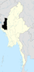 | |
| Hakha District | ||
| Matupi District | ||
| Mindat District | ||
| Cities and towns | ||
| States | ||
|---|---|---|
| Regions | ||
| Self-Administered Zones | ||
| Self-Administered Divisions | ||
| Union Territories | ||