Doringbaai
| Doringbaai | |
|---|---|
 | |
 Doringbaai  Doringbaai Doringbaai (South Africa)  Doringbaai Doringbaai (Africa) | |
| Coordinates: 31°49′S 18°14′E / 31.817°S 18.233°ECoordinates: 31°49′S 18°14′E / 31.817°S 18.233°E | |
| Country | South Africa |
| Province | Western Cape |
| District | West Coast |
| Municipality | Matzikama |
| Area[1] | |
| • Total | 1.79 km2 (0.69 sq mi) |
| Population (2011)[1] | |
| • Total | 1,260 |
| • Density | 700/km2 (1,800/sq mi) |
| Racial makeup (2011)[1] | |
| • Black African | 2.7% |
| • Coloured | 90.2% |
| • Indian/Asian | 0.1% |
| • White | 6.9% |
| • Other | 0.2% |
| First languages (2011)[1] | |
| • Afrikaans | 96.4% |
| • English | 2.7% |
| • Other | 1.0% |
| Time zone | UTC+2 (SAST) |
| Postal code (street) | 8151 |
| PO box | 8151 |
Doringbaai is a settlement in West Coast District Municipality in the Western Cape province of South Africa.
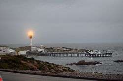
Doringbaai, previously known as Thornbay, is a small fishing village. The main economic activity is the packaging and export of crayfish. In the past, the bay at Doringbaai was used as an anchorage for the trade route; provisions were deposited here and transported to Vanrhynsdorp by camel. The lighthouse, one of the local landmarks, was built in 1963.[2]
References
- 1 2 3 4 "Main Place Doringbaai". Census 2011.
- ↑ "Doringbaai, Western Cape". SA Travel Directory. Archived from the original on 11 July 2015. Retrieved 10 July 2015.
| Wikimedia Commons has media related to Doringbaai. |
Municipalities and communities of West Coast District Municipality, Western Cape | ||
|---|---|---|
District seat: Moorreesburg | ||
| Matzikama | .svg.png) | |
| Cederberg | ||
| Bergrivier | ||
| Saldanha Bay | ||
| Swartland | ||
This article is issued from
Wikipedia.
The text is licensed under Creative Commons - Attribution - Sharealike.
Additional terms may apply for the media files.