Mweelrea
| Mweelrea | |
|---|---|
| Cnoc Maol Réidh; smooth bald hill | |
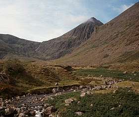
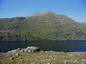 The west-flank of Mweelrea mountain as seen from across the Killary Harbour | |
| Highest point | |
| Elevation | 814 m (2,671 ft) [1] |
| Prominence | 779 m (2,556 ft) [1] |
| Listing | Marilyn, Hewitt |
| Coordinates | 53°38′10″N 9°49′52″W / 53.636°N 9.831°WCoordinates: 53°38′10″N 9°49′52″W / 53.636°N 9.831°W |
| Naming | |
| Translation | smooth bald hill (Irish) |
| Pronunciation | /mwiːlˈreɪ/ |
| Geography | |
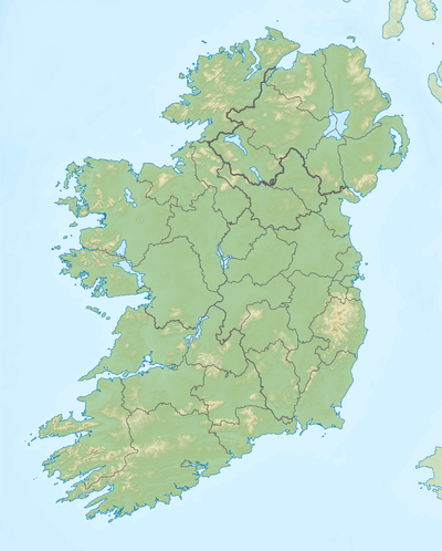 Mweelrea Location of Mweelrea in Ireland | |
| Location | County Mayo, Ireland |
| Parent range | Mweelrea Mountains |
| OSI/OSNI grid | L789668 |
| Topo map | OSi Discovery 37 |
| Geology | |
| Mountain type | Sandstone & conglomerate, ignimbrite[1] |
| Climbing | |
| Easiest route | "Silver Strand"[2] |
| Normal route | "The Ramp" (Lugmore corrie)[3] |
Mweelrea (/mwiːlˈreɪ/; from Irish Cnoc Maol Réidh, meaning 'smooth bald hill')[4][5] is an 814-metre (2,671 ft) mountain in County Mayo, Ireland. Mweelrea is the highest mountain in the western province of Connacht, and the 16th highest mountain in Ireland.[6][7] On a clear day, it is known for its extensive views.[8][7] Mweelrea, Ben Bury (795-metres), and Ben Lugmore (803-metres) are often called the Mweelrea range or the Mweelrea mountains.[lower-alpha 1]
As the highest mountain in Connacht, Mweelrea is often climbed in "Four Peaks Challenge" formats,[9] being the highest mountains in the four provinces of Ireland. The fastest and most straightforward way to summit Mweelrea is via the 8–kilometre "Silver Strand Route" which takes about 3 hours.[2] A more challenging route is from Doo Lough via the 13–kilometre "Ramp Route" which takes in Ben Bury and takes about 6 hours.[3]
Guidebooks note the range is often in poor weather, and that Ben Lugmore is particularly dangerous to navigate.[10] The full Mweelrea range can be climbed via the more strenuous, but highly regarded, "Mweelrea Horseshoe", a 16–kilometre route that takes in Ben Lugamore and Ben Bury, and takes 7 to 8 hours.[lower-alpha 2][7][10] The cliffs on the eastern Doo Lough-side of the range is known for rock-climbing, with routes from HS to E3.[11]
Highest points
The table below lists the highest major mountain peaks of the Mweelrea mountain range.[5]
| Rank | Mountain peak | Elevation | English Name |
|---|---|---|---|
| 1 | Maol Réidh | 814 m (2,671 ft) | Mweelrea |
| 2 | Binn Log Mhór | 803 m (2,635 ft) | Ben Lugmore |
| 3 | Ucht an Chreagáin | 795 m (2,608 ft) | Ben Bury |
| =4 | - | 790 m (2,590 ft) | Ben Lugmore (East Top) |
| =4 | - | 790 m (2,590 ft) | Ben Lugmore (West Top) |
| 6 | - | 495 m (1,624 ft) | Mweelrea SE Spur |
| 7 | Taobh na Binne‡ | 379 m (1,243 ft) | Teevnabinnia‡ |
(‡) While part of the Mweelrea range, Teevnabinna is rarely climbed, and in the "Mweelrea Horseshoe", is by-passed by going directly to the SE Spur.
Further reading
- Dillion, Paddy (1993). The Mountains of Ireland: A Guide to Walking the Summits. Cicerone. ISBN 978-1852841102.
- Fairbairn, Helen (2014). Ireland's Best Walks: A Walking Guide. Collins Press. ISBN 978-1848892118.
See also
| Wikimedia Commons has media related to Mweelrea Mountains. |
- Maumturks, major range in Connemara
- Twelve Bens, major range in Connemara
- List of Irish counties by highest point
- Lists of mountains in Ireland
- Lists of mountains and hills in the British Isles
Notes
- ↑ Even though the entire range of Mweelrea, Ben Bury and Ben Lugmore is not formally named (unlike the Twelve Bens, or Maumturks), it is often referred to as the "Mweelrea Range" in maps and guidebooks.
- ↑ The "horseshoe" or "loop" is usually done in a clockwise direction, starting at the "Delphi Bridge" (behind the "Delphi Mountain Resort") and heading to Mweelrea's unnamed Southeast Spur (495-metres), and then to Mweelrea, Ben Bury (795-metres) and Ben Lugmore (803-metres), before descending back to the "Delphi Bridge". The route has 3,510 ft of ascent and takes 7 to 8 hours.[7]
References
- 1 2 3 "Mweelrea Mountains Area / Mweelrea". MountainViews. Ordnance Survey Ireland. Retrieved June 29, 2015.
- 1 2 "Mweelrea: Silver Strand Route (Start at L76288 68802)". Mountainview.ie.
This is the easiest and quickest way to get to te top of Mweelrea, but it's mostly just a bog walk. I did it in just under 3 hours. You can park where the track leaves the road, or add in the road walk and park at the beach at the end of the road. The track to open land is marked with a cul de sac sign and there are no fences once you get through the gate. Care should be taken on the upper section of the walk and should not be attempted in high winds or when the cloud base comes in due to cliffs near the summit.
- 1 2 3 Russ Mills (15 July 2018). "Featured Hike – Mweelrea and Ben Bury via the 'Ramp'". mountaintrails.ie.
- ↑ Placenames Database of Ireland
- 1 2 Paul Tempan (February 2012). "Irish Hill and Mountain Names" (PDF). MountainViews.ie.
- ↑ "Irish Highest 100: The highest 100 Irish mountains with a prominence of +100m". Mountainviews.ie. September 2018.
- 1 2 3 4 Helen Fairbairn (30 December 2014). Ireland's Best Walks: A Walking Guide (Walking Guides). Collins Press. ISBN 978-1848892118.
ROUTE 29: Mweelrea. Two airy ridges and incredible coastal views make this one of Ireland's finest walks. [...] If I were pressed to come up with a list of my favourite walks in Ireland, this horseshoe circuit on Mweelrea would probably make it into my top three.
- ↑ Michael Guilfoyle (6 April 2016). "A Walk for the Weekend: the magic of Mweelrea". Irish Times.
My favourite mountain in the world is Mweelrea. From its summit, 16 years ago, I watched the last light of the millennium sink into a hushed Atlantic.
- ↑ "Interview: Nikki Bradley on her Upcoming Four Peaks Challenge". Outsider Magazine. 9 July 2018.
- 1 2 Paddy Dillion. The Mountains of Ireland: A Guide to Walking the Summits. Cicerone Press. ISBN 978-1852841102.
Route 53: Mweelrea Loop. This is a fine group of mountains but best reserved for a clear day
- ↑ "Doo Lough: Lower Crag and Upper Crag". Irish Climbing Online Database.
External links
Mountains and hills of Great Britain and Ireland | ||
|---|---|---|
| Scotland |  | |
| England | ||
| Wales | ||
| Northern Ireland | ||
| Republic of Ireland | ||
Mountains and hills of Connacht | ||
|---|---|---|
| Achill Island |  | |
| Breifne | ||
| Dartry Mountains | ||
| Maumturks | ||
| Nephin Range | ||
| Ox Mountains | ||
| Partry Mountains | ||
| Sheeffry Range | ||
| Twelve Bens | ||
| Others | ||
Highest mountains of Ireland (by province) | ||
|---|---|---|
| Munster |
|  |
| Leinster |
| |
| Ulster |
| |
| Connacht |
| |