Maumturks
| Maumturks (Maamturks) | |
|---|---|
| Irish: Mhám Toirc; pass of the boar | |
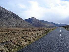 Maumturk Mountains, looking southeastwards from the Inagh Valley with Knocknahillion's distinctive "diagonal stripes" featuring in the centre. | |
| Highest point | |
| Peak | Binn idir an Dá Log |
| Elevation | 702 m (2,303 ft) |
| Coordinates | 53°29′N 9°36′W / 53.48°N 9.60°WCoordinates: 53°29′N 9°36′W / 53.48°N 9.60°W |
| Naming | |
| Translation | The pass of the boar (Irish language) |
| Geography | |
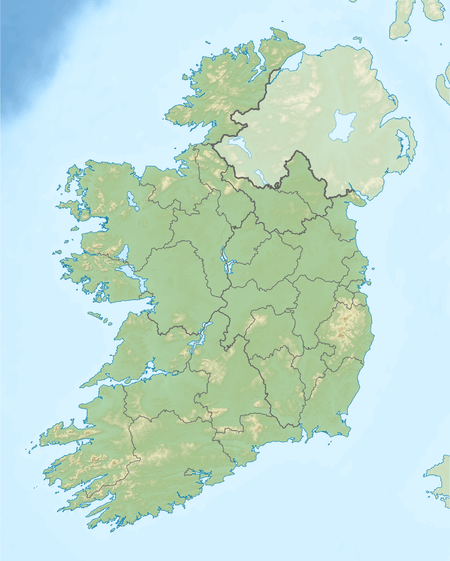 Maumturks (Maamturks) Location of the Maunturks | |
| Location | Connemara, County Galway, Ireland |
| Country | Republic of Ireland |
| Provinces of Ireland | Connacht |
| Geology | |
| Mountain type | Pale quartzites, grits, graphitic top |
| Climbing | |
| Normal route | "Maamturks Challenge"[lower-alpha 1][1] |
The Maumturks or Maamturks (Irish: Sléibhte Mhám Toirc; the mountain of the pass of the boar)[lower-alpha 2] is a long broadly-straight mountain range, consisting of weathered quartzite peaks in its central section, located in Connemara[lower-alpha 3] in County Galway, in the west of Ireland. The range lies opposite the Twelve Bens, on the other side of the Inagh Valley (a Western Way route). The walk of the full range (from Maam Cross to Leenaun), is considered one of the "great classic ridge-walks of Ireland",[3] and since 1975, the University College Galway Mountaineering Club, has run the annual "Maamturks Challenge", a walk covering the entire 25–kilometre range in a single day.[1][lower-alpha 1] Near the centre of the range in a deep valley is Irish: Máméan, a site of pilgrimage dedicated to Saint Patrick.[4]
Highest points
The table below lists some of the highest major mountain peaks of the Maumturk Mountains.[2]
| Rank | Mountain peak | Elevation | English Name |
|---|---|---|---|
| 1 | Binn idir an Dá Log | 702 m (2,303 ft) | Benadolug‡ |
| 2 | Leitir Bhriocáin | 667 m (2,188 ft) | Letterbreckaun |
| 3 | Binn Mhór | 661 m (2,169 ft) | BinnMhor |
| 4 | Binn Chaonaigh | 633 m (2,077 ft) | Binn Chaonaigh |
| 5 | Mullach Glas | 622 m (2,041 ft) | Mullach Glas |
| 6 | An Meall Dubh | 618 m (2,028 ft) | Leenaun Hill |
| 7 | Binn Mhairg | 612 m (2,008 ft) | Binn Mhairg |
| 8 | Corcóg* | 609 m (1,998 ft) | Corcogemore* |
| 9 | Cnoc na hUilleann | 607 m (1,991 ft) | Knocknahillion |
(‡) The anglicised version is rarely used or marked on any maps; a more common anglicised name is the incorrect name of "Barrslievenaroy" (or "Baurslievenaroy"), which is a nearby townland on the slopes of Binn idir an Da Log.
(*) Cartographer Tim Robinson notes: "the Ordnance Survey has been incorrectly calling this mountain 'Leckavrea' for a hundred and fifty years." "Lackavrea" (Ir. Leic Aimhréidh) is the mountain to the east on the other side of Mám Aodha.[2]

Rock climbing
While the Maumturks are not known for rock climbing, the Loch Mhám Ochóige area of the range has rock climbs in the V-Diff to HVS grades.[5]
Further reading
- Lynam, Joss; Robinson, Tim (1988). Mountains of Connemara: Hill Walker's Guide. Folding Landscape. ISBN 978-0950400242.
- Dillion, Paddy (1993). The Mountains of Ireland: Guide to Walking the Summits. Cicerone. ISBN 978-1852841102.
- Dillion, Paddy (2001). Connemara: Collins Rambler's guide. Harper Collins. ISBN 978-0002201216.
- Fairbairn, Helen (2014). Ireland's Best Walks: A Walking Guide. Collins Press. ISBN 978-1848892118.
- Connemara (Superwalker) Map (Waterproof Folded Map) (1:30,000 scale). Harvey Maps. 2015. ISBN 978-1851373383.
See also
- Mweelrea, major range in Killary Harbour
- Twelve Bens, major range in Connemara
- Lists of mountains in Ireland
- Lists of mountains and hills in the British Isles
Notes
- 1 2 The entire route covers just under 25 kilometres, 7,600 ft of elevation, and generally takes 10–12 hours for competent hill walkers to complete
- ↑ The direct translation of Mhám Toirc is "pass of the boar"; there are several "turk" placenames in Connemara.[2]
- ↑ The range is outside the boundary of the Connemara National Park and on private property, but climbing access is granted.
References
- 1 2 "The Maumturks Challenge". University College Galway Mountaineering Club. 2018.
- 1 2 3 Paul Tempan (February 2012). "Irish Hill and Mountain Names" (PDF). MountainViews.ie.
- ↑ Helen Fairbairn (30 December 2014). Ireland's Best Walks: A Walking Guide (Walking Guides). Collins Press. ISBN 978-1848892118.
Route 35 Maumturks (North), Route 36 Maumturks (South)
- ↑ "Máméan Pilgrimage". National Museum of Ireland.
High up the slopes of the Maum Turk Mountains in Connemara there is a natural passage-way known as Máméan (pass of the birds). At the summit of this rugged track you will find an ancient pilgrim site dedicated to St. Patrick.
- ↑ "Maumturks". Irish Climbing Wiki.
Location - The crag is at grid reference L 876 532 near Mám Ochóige one mile from the road. on west flank of col between Knocknahillion and point 2305, below and west of lake on the Maamturk ridge The crag is not too high up and often in the sun.
External links
| Wikimedia Commons has media related to Maumturk Mountains. |
- The Maamturks Challenge, University College Galway Mountaineering Club
- The Maamturks Challenge: Routecard (2015)
- Mountainview: The Maumturks Range
- The Maumturks Ridge Walk: Illustrated Guide
Mountains and hills of Great Britain and Ireland | ||
|---|---|---|
| Scotland |  | |
| England | ||
| Wales | ||
| Northern Ireland | ||
| Republic of Ireland | ||
