Twelve Bens
| Twelve Bens (Twelve Pins) | |
|---|---|
| Irish: Na Beanna Beola; the peaks of Beola[lower-alpha 1] | |
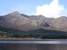 Peak of Bencorr, and its northeast ridge, looking from across Lough Inagh; Gleann Eighneach valley, noted for rock-climbs, is just over the ridge. | |
| Highest point | |
| Peak | Benbaun |
| Elevation | 729 m (2,392 ft) |
| Coordinates | 53°30′N 9°49′W / 53.50°N 9.81°WCoordinates: 53°30′N 9°49′W / 53.50°N 9.81°W |
| Naming | |
| Translation | The peaks of Beola[lower-alpha 1] (Irish language) |
| Geography | |
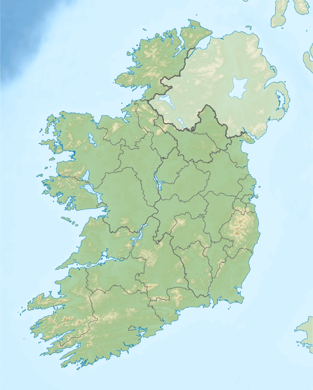 Twelve Bens (Twelve Pins) Location of the Twelve Bens | |
| Location | Connemara, County Galway, Ireland |
| Country | Republic of Ireland |
| Provinces of Ireland | Connacht |
| Geology | |
| Type of rock | quartzites, grits, graphitic |
| Climbing | |
| Normal route |
|
The Twelve Bens or Twelve Pins (Irish: Na Beanna Beola; the peaks of Beola)[lower-alpha 1] is a mountain range of sharp-peaked quartzite summits and ridges located in the Connemara National Park[lower-alpha 4] in County Galway, in the west of Ireland. Topographically, the range is partnered with the Maumturks range on the other side of the Glen Inagh valley (a Western Way route). The highest point is Benbaun at 729 meters (2,392 ft). The range is popular with hill walkers, rock climbers,[2] and fell runners. The 15–kilometre "Glencoaghan Horseshoe" (Irish: Gleann Chóchan)[lower-alpha 2] is noted as providing some of the "most exhilarating mountaineering in Ireland",[6] and "a true classic".[7] A more serious undertaking is the 28–kilometre "Twelve Bens Challenge", climbing all bens in a single day.[lower-alpha 3]
Highest points
The table lists the 12 highest major mountain peaks of the Twelve Bens, all with a topographic elevation of at least 516 metres (1,693 ft). There are a number of mountains higher than Benglenisky, but do not have sufficient prominence to be included in this list.[1]
| Rank | Mountain peak | Elevation | English Name |
|---|---|---|---|
| 1 | Binn Bhán | 729 m (2,392 ft) | Benbaun |
| 2‡ | Binn Chorr* | 711 m (2,333 ft) | Bencorr* |
| 3‡ | Binn Dubh | 696 m (2,283 ft) | Bencollaghduff |
| 4‡ | Binn Bhraoin | 691 m (2,267 ft) | Benbreen |
| 5‡ | Binn Doire Chláir | 677 m (2,221 ft) | Derryclare |
| 6‡ | Binn Gabhar | 664 m (2,178 ft) | Bengower |
| 7 | Meacanach | 654 m (2,146 ft) | Muckanaght |
| 8 | Binn Fraoigh | 638 m (2,093 ft) | Benfree |
| 9 | An Chailleach | 632 m (2,073 ft) | Bencullagh |
| 10 | Binn Breac | 582 m (1,909 ft) | Benbrack |
| 11‡ | Ben Letterry | 577 m (1,893 ft) | Ben Letterry |
| 12 | Binn Glean Uisce | 516 m (1,693 ft) | Benglenisky |
(‡) Part of the classic "Glencoaghan Horseshoe" climb (or also known as the "Derryclare Horseshoe").[lower-alpha 2]
(*) Also known by the name "Binn an tSaighdiúra", or "Soldier's Peak", which is a lesser-peak of Bencorr.
.jpg)
Rock climbing
The twelve bens have a number of rock climbing locations, the most notable of which is the "Gleann Eighneach" valley and the north face of Benncorr (also known as Binn an tSaighdiúra), with the well-regarded routes of Carrot Ridge (275m D), and Seventh Heaven (330m HS).[2]
Further reading
- Lynam, Joss; Robinson, Tim (1988). Mountains of Connemara: Hill Walker's Guide. Folding Landscape. ISBN 978-0950400242.
- Dillion, Paddy (1993). The Mountains of Ireland: A Guide to Walking the Summits. Cicerone. ISBN 978-1852841102.
- Dillion, Paddy (2001). Connemara: Collins Rambler's guide. Harper Collins. ISBN 978-0002201216.
- Fairbairn, Helen (2014). Ireland's Best Walks: A Walking Guide. Collins Press. ISBN 978-1848892118.
- Connemara (Superwalker) Map (Waterproof Folded Map) (1:30,000 scale). Harvey Maps. 2015. ISBN 978-1851373383.
See also
- Mweelrea, major range in Killary Harbour
- Maumturks, major range in Connemara
- List of Irish counties by highest point
- Lists of mountains in Ireland
- Lists of mountains and hills in the British Isles
Notes
- 1 2 3 The translation is "the peaks of Beola" who was believed to be a giant and chieftain of the Fir Bolg, whose name features in the village Tuaim Beola (Toombeola).[1]
- 1 2 3 Also known as the "Derryclare Horseshoe" as it is normally started from the Derryclare end (e.g. counterclockwise), is a 14 to 16 kilometre "horseshoe"-shaped circuit (the final length depending on whether the "loop" is completed by walking back to the base of "Derryclare"), that takes in six of the twelve bens, almost 5,000 ft of elevation, and takes circa 6 to 9 hours to complete depending on ability and fitness.[3][4][5]
- 1 2 The "12 Bens Challenge" was organised by the Beanna Beola Hillwalking Club on a yearly basis since 2006; it is for advanced hill-walkers only, and covers 28 kilometres, 8,300 ft of elevation, and takes circa 12–14 hours to complete.[8]
- ↑ Only part of the range is inside the boundary of the Connemara National Park; the rest is on private property, but climbing access is granted.
References
- 1 2 Paul Tempan (February 2012). "Irish Hill and Mountain Names" (PDF). MountainViews.ie.
- 1 2 "Glenn Eighneach". Irish Climbing Wiki.
The finest rock formations in the Twelve Bens are found in the south wall of Gleann Eidheanach (Glen Inagh), running from Binn an Choire Bhig to Mám na bFhonsaí, east of Binn Dubh (L808530).
- ↑ Liam Johnson (12 September 2015). "Glencoaghan Horseshoe: Viewranger Statistics". theramblers.ie.
- ↑ "Glencoaghan Horseshoe (anticlockwise)". viewranger maps. 2013.
- ↑ "More Challenging Climbing: The Glencoaghan Horseshoe". Walk Conemara.
- ↑ Tom Doherty (22 June 2016). "A walk for the weekend: The Twelve Bens of Connemara are a hard walk but worth it". Irish Times.
Even if you had to crawl across bogs to get to them, it would be worth it as the nine [should be six] peaks which form the Glencoaghan Horseshoe provide some of the most exhilarating mountaineering on this island.
- ↑ Helen Fairbairn (30 December 2014). Ireland's Best Walks: A Walking Guide (Walking Guides). Collins Press. ISBN 978-1848892118.
ROUTE 34: The Glencoaghan Horseshoe. A true classic
- ↑ "12 Bens Challenge". Na Beanna Beola Hill Walking Club. 2018.
The route begins at the Inagh Valley Inn and ends at the Bard’s Den in Letterfrack. The total distance covered is approximately 28km and the total height gain for the route is approximately 2530m (8300ft). On average it takes 12–14 hours to complete and should only be attempted by competent hill-walkers.
| Wikimedia Commons has media related to Twelve Bens. |
External links
- Mountainview: The Twelve Bens Range
- The Twelve Bens Challenge: Routecard (2015)
- Irish Rock Climbing Database: Gleann Eighneach
- Irish Rock Climbing Database: Inagh Valley (Benorr & Derryclare)
Mountains and hills of Great Britain and Ireland | ||
|---|---|---|
| Scotland |  | |
| England | ||
| Wales | ||
| Northern Ireland | ||
| Republic of Ireland | ||
