Bistrița-Năsăud County
| Bistrița-Năsăud County Județul Bistrița-Năsăud | ||
|---|---|---|
| County | ||
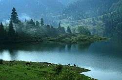 Colibița Lake, Bistrița-Năsăud County | ||
| ||
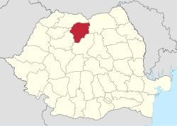 Location of Bistrița-Năsăud County in Romania | ||
| Country |
| |
| Development region1 | Nord-Vest | |
| Historic region | Transylvania | |
| Capital city (Reședință de județ) | Bistrița | |
| Government | ||
| • Type | County Board | |
| • President of the County Council | Emil Radu Moldovan | |
| • Prefect2 | Nastasia Bob | |
| Area | ||
| • Total | 5,355 km2 (2,068 sq mi) | |
| Area rank | 26th in Romania | |
| Population (2011) | ||
| • Total | 277,861 | |
| • Rank | 35th in Romania | |
| • Density | 52/km2 (130/sq mi) | |
| Time zone | UTC+2 (EET) | |
| • Summer (DST) | UTC+3 (EEST) | |
| Postal Code | 42wxyz3 | |
| Area code(s) | +40 x634 | |
| Car Plates | BN5 | |
| GDP | US$ 2.31 billion (2008) | |
| GDP/capita | US$ 7,391 (2008) | |
| Website |
County Council County Prefecture | |
|
1The developing regions of Romania have no administrative role, but were formed in order to manage funds from the European Union 2 as of 2007, the Prefect is not a politician, but a public functionary. He (or she) is not allowed to be a member of a political party, and is banned from having any political activity in the first six months after resigning (or being excluded) from the public functionaries' corps. 3w, x, y, and z are digits that indicate the city, the street, part of the street, or even the building of the address 4x is a digit indicating the operator: 2 for the former national operator, Romtelecom, and 3 for the other ground telephone networks 5used on both the plates of the vehicles that operate only in the county limits (like utility vehicles, ATVs, etc.), and the ones used outside the county | ||
Bistrița-Năsăud (Romanian pronunciation: [ˈbistrit͡sa nəsəˈud] (![]()
Name
In Hungarian, it is known as Beszterce-Naszód megye, and in German as Kreis Bistritz-Nassod. The name is identical with the county created in 1876, Beszterce-Naszód County (Romanian: Comitatul Bistriţa-Năsăud) in the Kingdom of Hungary (the county was recreated in 1940 after the Second Vienna Award, as it became part of Hungary again). Except these, as part of Romania, until 1925 the former administrative organizations were kept when a new county system was introduced. Between 1925-1940 and 1945-1950, most of its territory belonged to the Năsăud County, with smaller parts belonging to the Mureș, Cluj and Someș counties.
Demographics
In October 31, 2011, it had a population of 277,861 and the population density was 51/km².[1]
- Romanians – 89.9%
- Hungarians – 5.3%
- Roma – 4.3%
- Germans (Transylvanian Saxons) – 0.1%
83.1% of inhabitants were Romanian Orthodox, 6.3% Pentecostal, 4.6% Reformed, 2.3% Greek-Catholic, 1.2% Roman Catholic, 0.8% Baptist, 0.7% belonged to "another religion", 0.5% Seventh-day Adventist and 0.5% other or none.
| Year | County population[2] |
|---|---|
| 1948 | 233,650 |
| 1956 | 255,789 |
| 1966 | 269,954 |
| 1977 | 286,628 |
| 1992 | 327,238 |
| 2002 | 311,657 |
| 2011 | 277,861 |
Geography
The county has a total area of 5,355 km². One third of this surface represents the mountains from the Eastern Carpathians group: the Țibleș, Rodna, Bârgău and Călimani Mountains. The rest of the surface represents the North-East side of the Transylvanian Plateau.
The main river crossing the county is the Someșul Mare River River. On the Bistrița River there is a big dam and a lake.
Neighbours
- Suceava County in the East.
- Cluj County in the West.
- Maramureș County in the North.
- Mureș County in the South.
Politics
The Bistrița-Năsăud County Council, elected at the 2016 local government elections, is made up of 31 counselors, with the following party composition:[3]
| Party | Seats | Current County Council | |||||||||||||||||||
|---|---|---|---|---|---|---|---|---|---|---|---|---|---|---|---|---|---|---|---|---|---|
| Social Democratic Party | 19 | ||||||||||||||||||||
| National Liberal Party | 9 | ||||||||||||||||||||
| Alliance of Liberals and Democrats | 3 | ||||||||||||||||||||
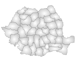
Administrative divisions
.jpg)
.jpg)
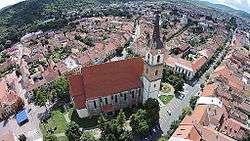
Bistriţa-Năsăud County has 1 municipality, 3 towns and 58 communes.
- Municipalities
- Bistrița – capital city; 70,493 (as of 2011)
- Towns
- Communes
- Bistrița Bârgăului
- Braniștea
- Budacu de Jos
- Budești
- Căianu Mic
- Cetate
- Chiochiș
- Chiuza
- Ciceu-Giurgești
- Ciceu-Mihăiești
- Coșbuc
- Dumitra
- Dumitrița
- Feldru
- Galații Bistriței
- Ilva Mare
- Ilva Mică
- Josenii Bârgăului
- Leșu
- Lechința
- Livezile
- Lunca Ilvei
- Maieru
- Matei
- Măgura Ilvei
- Mărișelu
- Miceștii de Câmpie
- Milaș
- Monor
- Negrilești
- Nimigea
- Nușeni
- Parva
- Petru Rareș
- Poiana Ilvei
- Prundu Bârgăului
- Rebra
- Rebrișoara
- Rodna
- Romuli
- Runcu Salvei
- Salva
- Sânmihaiu de Câmpie
- Șieu
- Șieu-Odorhei
- Șieu-Măgheruș
- Șieuț
- Șintereag
- Silivașu de Câmpie
- Spermezeu
- Șanț
- Târlișua
- Teaca
- Telciu
- Tiha Bârgăului
- Uriu
- Urmeniș
- Zagra
People
Natives of the county include:
References
| Wikimedia Commons has media related to Bistrița-Năsăud County. |
- ↑ "COMUNICAT DE PRESĂ : 2 februarie 2012 privind rezultatele provizorii ale Recensământului Populaţiei şi Locuinţelor – 2011" (PDF). Recensamantromania.ro. Retrieved 11 April 2018.
- ↑ National Institute of Statistics, "Populația la recensămintele din anii 1948, 1956, 1966, 1977, 1992, 2002 și 2011" Archived 22 September 2006 at the Wayback Machine.
- ↑ "Mandate de CJ pe judete si competitori" (in Romanian). Biroul Electoral Central. 10 June 2016. Retrieved 16 June 2016.
