Someș County
| Județul Someș | ||
|---|---|---|
| County (Județ) | ||
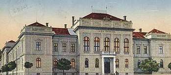
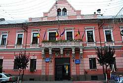 Someș County Prefecture in Dej, currently the Dej city hall. | ||
| ||
 | ||
| Country |
| |
| Historic region | Transylvania | |
| Capital city (Reședință de județ) | Dej | |
| Established | 1925 | |
| Ceased to exist | Administrative reform of 1950 | |
| Area | ||
| • Total | 3,965 km2 (1,531 sq mi) | |
| Population (1930) | ||
| • Total | 219,335 | |
| • Density | 55/km2 (140/sq mi) | |
| Time zone | UTC+2 (EET) | |
| • Summer (DST) | UTC+3 (EEST) | |
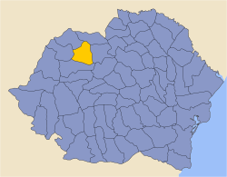
Someș County is one of the historic counties of Transylvania, Romania. The county seat was Dej.[1]
In 1938, the county was disestablished and incorporated into the newly formed Ținutul Crișuri,[2] but it was re-established in 1940 after the fall of Carol II's regime - only to be abolished 10 years later by the Communist regime.[2]
Geography
Someș County covered 3,965 km2[1] and was located in Transylvania. Currently, the territory that comprised Someș County is now located in the Bistrița-Năsăud, Maramureș, Cluj and Sălaj counties. It neighbored Satu Mare and Maramureș counties to the north, Năsăud County to the east, Cluj County to the south, and Sălaj County to the west.[1]
Historical County
Prior to World War I, the territory of the county belonged to Austria-Hungary, identical with the Szolnok-Doboka County of Hungary. The territory was transferred to Romania from the Kingdom of Hungary in 1920, under the Treaty of Trianon. The Romanian name of the county became Someș-Dăbâca County. After the administrative unification law in 1925, the county was renamed to Someș County, and its territory was reorganized. In 1940, it was transferred back to Hungary with the rest of Northern Transylvania under the Second Vienna Award. Beginning in 1944, Romanian forces with Soviet assistance recaptured the territory and re-established jurisdiction in 1945. The transfer of the county per the Treaty of Trianon was reaffirmed in the Paris Peace Treaties, 1947. The county was finally disestablished by the communist government of Romania in 1950.
Administrative organization

Administratively, Someș County was divided originally into six districts (plăși):[1]
- Plasa Beclean (headquarters at Beclean)
- Plasa Dej (headquarters at Dej)
- Plasa Gârbou (headquarters at Gârbou)
- Plasa Gherla (headquarters at Gherla)
- Plasa Ileanda (headquarters at Ileanda)
- Plasa Lăpuş (headquarters at Lăpuş)
Later, a seventh district was added:
- Plasa Chiochiş (headquarters at Chiochiş)
Population
According to the 1930 census, the county counted 219,335 inhabitants, of which 77.5% were Romanians, 15.4% Hungarians, and 4.8% Jews, and other smaller minorities. From a religious point of view, the population was mostly Greek Catholics (63.5%), followed by Eastern Orthodox (15.0%), Reformed (12.8%), Roman Catholics (3.2%), and other smaller minorities.[3]
Urban population
The urban population consisted of 41.3% Romanians, 33.0% Hungarians, 20.1% Jews, 1.7% Armenians, and other smaller minorities. As a mother tongue in the urban area Romanian predominated (41.4%), followed by Hungarian (36.8%), Yiddish (18.3%), German (1.0%) and others. From the religious point of view, the population was made up of Greek Catholics (33.2%), followed by Reformed (22.6%), Jews (20.2%), Roman Catholics (11.9%), Eastern Orthodox (8.6%), Armenian-Catholic (2.3%), and other smaller denominations.[3]
References
- 1 2 3 4 "Portretul României interbelice - Județul Someș" (in Romanian). memoria.ro. Retrieved 17 August 2016.
- 1 2 "Organizarea administrativ-teritorială a României 1864-1989" (in Romanian). bzf.ro. 7 May 2013. Archived from the original on 29 September 2014. Retrieved 17 August 2016.
- 1 2 Recensământul general al populației României din 29 decemvrie 1930, Vol. II, pag. 728-731
External links
| Wikimedia Commons has media related to Interwar Someș County. |
- (in Romanian) Someș County on memoria.ro