Bà Rịa
| Bà Rịa City Thành phố Bà Rịa | |
|---|---|
| Provincial city (Class-2) | |
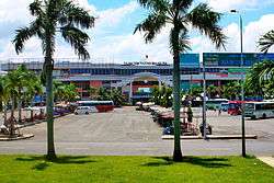 Bà Rịa commercial center | |
 Bà Rịa City Location of in Vietnam | |
| Coordinates: 10°30′N 107°10′E / 10.500°N 107.167°E | |
| Country |
|
| Province | Bà Rịa–Vũng Tàu |
| Established town | 2 June 1994 |
| Government[1] | |
| • chairman of the municipal committee | Phạm Chí Lợi |
| Area | |
| • Total | 91.46 km2 (35.31 sq mi) |
| Population (2014) | |
| • Total | 153,000 |
| • Density | 1,700/km2 (4,300/sq mi) |
| Time zone | UTC+07:00 (ICT) |
| Climate | Aw |
Bà Rịa (Vietnamese: [ɓaː˧˩ ʐiə˧˨˧ˀ] (![]()
Location
Bà Rịa is located 90 km east-south-east of Ho Chi Minh City, 20 km northwest of the petroleum city of Vũng Tàu. Bà Rịa borders Châu Đức District and part of Tân Thành District to the north, Vũng Tàu to the south, Long Điền District to the east, and Tân Thành District to the west. Bà Rịa has an area of 197.5 km², including seven urban wards (phường) (Long Toàn, Phước Hiệp, Phước Hưng, Phước Nguyên, Phước Trung, Long Hương, and Kim Dinh), and 3 rural communes (xã) (Hòa Long, Tân Hưng, and Long Phước). As of 2011, the town has 122,424 inhabitants, the density is 3500 hab/km².
Administration
The city was promoted from the town of Bà Rịa to the capital city on 22 August 2012.[2] The town was founded on 2 June 1994 from the split of the district of Châu Thành into districts of Châu Đức, Tân Thành, and Bà Rịa town. Many provincial agencies have been relocated from Vũng Tàu to Bà Rịa. By 2007, this city was a 3rd-class municipality in Vietnam[3] and upgraded to 2nd-class municipality on 27 November 2014.
Transportation
Bà Rịa is an important transport hub of the province, on Route 51, Road 52 and Road 56. Bà Rịa is situated about 48 km southeast of the planned Long Thanh International Airport on National Route 51 (Vietnam). Bà Rịa has Bà Rịa Secres Port. It is connected to Xuân Lộc by road.
Tourism
Bà Rịa is on the way from Ho Chi Minh City to the seaside resorts at Long Hải and Bình Châu hot spring.
References
- ↑ http://baria.baria-vungtau.gov.vn/front-end/index.asp?website_id=39&menu_id=950&parent_menu_id=950&article_id=1900&fuseaction=DISPLAY_SINGLE_ARTICLE
- ↑ http://news.gov.vn/Home/Ba-Ria-city-established/20128/15440.vgp
- ↑ "Bà Rịa town will be upgraded to city" (in Vietnamese). VnEconomy. July 16, 2012. Retrieved July 20, 2012.
Coordinates: 10°30′N 107°10′E / 10.500°N 107.167°E
| Ho Chi Minh City | 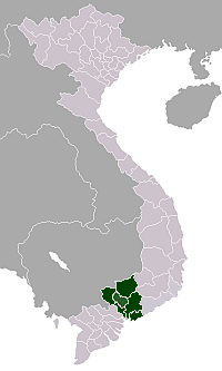 | |
|---|---|---|
| Bà Rịa-Vũng Tàu Province | ||
| Bình Dương Province |
| |
| Bình Phước Province |
| |
| Đồng Nai Province | ||
| Tây Ninh Province | ||
※ denotes provincial seat. | ||