Avonmore, Pennsylvania
| Avonmore, Pennsylvania | |
|---|---|
| Borough | |
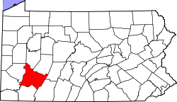
 Location of Avonmore in Westmoreland County, Pennsylvania. | |
 Avonmore, Pennsylvania Location of Avonmore in Westmoreland County, Pennsylvania. | |
| Coordinates: 40°31′40″N 79°27′58″W / 40.52778°N 79.46611°WCoordinates: 40°31′40″N 79°27′58″W / 40.52778°N 79.46611°W | |
| Country | United States |
| State | Pennsylvania |
| County | Westmoreland |
| Government | |
| • Type | Borough Council |
| Area[1] | |
| • Total | 1.56 sq mi (4.03 km2) |
| • Land | 1.47 sq mi (3.81 km2) |
| • Water | 0.09 sq mi (0.22 km2) |
| Elevation | 1,007 ft (307 m) |
| Population (2010) | |
| • Total | 1,011 |
| • Estimate (2016)[2] | 973 |
| • Density | 661.45/sq mi (255.45/km2) |
| Time zone | UTC-5 (Eastern (EST)) |
| • Summer (DST) | UTC-4 (EDT) |
| Zip code | 15618 |
| Area code(s) | 724 Exchange: 697 |
| FIPS code | 42-03688 |
Avonmore is a borough in Westmoreland County, Pennsylvania, United States. The population was 820 at the 2000 census.
Geography
Avonmore is located at 40°31′40″N 79°27′58″W / 40.52778°N 79.46611°W (40.527750, -79.466186).[3]
According to the United States Census Bureau, the borough has a total area of 1.6 square miles (4.1 km2), of which 1.5 square miles (3.9 km2) is land and 0.1 square miles (0.3 km2) (6.83%) is water.
Demographics
| Historical population | |||
|---|---|---|---|
| Census | Pop. | %± | |
| 1900 | 630 | — | |
| 1910 | 1,262 | 100.3% | |
| 1920 | 1,242 | −1.6% | |
| 1930 | 1,240 | −0.2% | |
| 1940 | 1,354 | 9.2% | |
| 1950 | 1,367 | 1.0% | |
| 1960 | 1,351 | −1.2% | |
| 1970 | 1,267 | −6.2% | |
| 1980 | 1,234 | −2.6% | |
| 1990 | 1,089 | −11.8% | |
| 2000 | 820 | −24.7% | |
| 2010 | 1,011 | 23.3% | |
| Est. 2016 | 973 | [2] | −3.8% |
| Sources:[4][5] | |||
As of the census[6] of 2000, there were 820 people residing in the borough. However, that population has declined considerably in the last 13 years. The population density was 547.9 people per square mile (211.1/km²). There were 376 housing units at an average density of 251.2 per square mile (96.8/km²). The racial makeup of the borough was 98.17% White, 1.22% African American, 0.37% Asian, 0.12% from other races, and 0.12% from two or more races. Hispanic or Latino of any race were 0.37% of the population.
There were 344 households out of which 26.5% had children under the age of 18 living with them, 56.4% were married couples living together, 8.4% had a female householder with no husband present, and 31.7% were non-families. 30.5% of all households were made up of individuals and 18.0% had someone living alone who was 65 years of age or older. The average household size was 2.35 and the average family size was 2.89.
In the borough the population was spread out with 21.6% under the age of 18, 5.1% from 18 to 24, 25.2% from 25 to 44, 24.6% from 45 to 64, and 23.4% who were 65 years of age or older. The median age was 43 years. For every 100 females, there were 83.0 males. For every 100 females age 18 and over, there were 78.6 males.
About 7.7% of families and 9.2% of the population were below the poverty line, including 19.2% of those under age 18 and 6.8% of those age 65 or over
Notable people
- Jill Corey, singer
- Alexis Knapp, actress and singer
In the media
Avonmore is where much of the 2012 movie "Promised Land" was filmed.[7]
References
- ↑ "2016 U.S. Gazetteer Files". United States Census Bureau. Retrieved Aug 14, 2017.
- 1 2 "Population and Housing Unit Estimates". Retrieved June 9, 2017.
- ↑ "US Gazetteer files: 2010, 2000, and 1990". United States Census Bureau. 2011-02-12. Retrieved 2011-04-23.
- ↑ "Census of Population and Housing: Decennial Censuses". United States Census Bureau. Archived from the original on 2006-02-08. Retrieved 2012-03-04.
- ↑ "Incorporated Places and Minor Civil Divisions Datasets: Subcounty Resident Population Estimates: April 1, 2010 to July 1, 2012". Population Estimates. U.S. Census Bureau. Archived from the original on 17 June 2013. Retrieved 11 December 2013.
- ↑ "American FactFinder". United States Census Bureau. Archived from the original on 2013-09-11. Retrieved 2008-01-31.
- ↑ Finding Promised Land, Focus Pictures, November, 12, 2012.
| Counties |  Map of the Pittsburgh Tri-State with green counties in the metropolitan area and yellow counties in the combined area. | |
|---|---|---|
| Major cities | ||
| Cities and towns 15k-50k (in 2010) | ||
| Airports | ||
| Topics | ||
| ||