Walberton
| Walberton | |
|---|---|
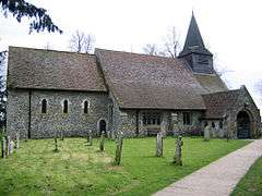 St Mary's Church, Walberton | |
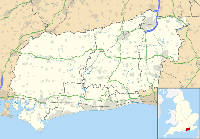 Walberton Walberton shown within West Sussex | |
| Area | 10.44 km2 (4.03 sq mi) |
| Population | 2,174 (Civil Parish.2011)[1] |
| • Density | 208/km2 (540/sq mi) |
| OS grid reference | SU972059 |
| • London | 50 miles (80 km) NNE |
| Civil parish |
|
| District | |
| Shire county | |
| Region | |
| Country | England |
| Sovereign state | United Kingdom |
| Post town | ARUNDEL |
| Postcode district | BN18 |
| Dialling code | 01243 |
| Police | Sussex |
| Fire | West Sussex |
| Ambulance | South East Coast |
| EU Parliament | South East England |
| UK Parliament | |
Walberton is a village and civil parish in the Arun District of West Sussex, England, five miles (8 km) north-west of Littlehampton, and south of the A27 road. The land rises from 10 to 35 metres above sea level, a quarter of the height of the nearest foothill, Nore Hill, of the South Downs, which is outside the parish to the north. The civil parish includes the smaller village of Binsted to the east and the larger neighbourhood of Fontwell, less than a kilometre to the north-west. Walberton has a medieval church next to its clustered centre. Binsted's medieval church retains its original setting of village houses dispersed over farm fields.
Sites and amenities
St Mary's Church in Walberton has a Saxon font and west wall. The Holly Tree is recorded as a public house from 1845 and received its present name in 1867.[2] Towards the end of the village, there is a small duck pond. There are a few shops and a post office next to the modern village hall.
Binsted has a pub, the Black Horse and a Norman church built in AD 1140 by the monks of Tortington Priory to the immediate east.[3] Roman and medieval pottery and tile kilns have been excavated there.[4] Binsted also has a traditional summer festival, Strawberry Fair, where locally grown produce is sold for charity. Part of Binsted is within the South Downs National Park. The whole of Binsted's countryside was originally assessed by the Countryside Agency as meeting the criteria for inclusion.

Governance
The electoral ward named Walberton stretches north-east to Madehurst, with a total population taken at the 2011 census of 2,889.[5]
Notable people
- Sir William Anson (1843–1914), jurist, academic and politician, was born in Walberton.[6]
- Frederick Marquis, 1st Earl of Woolton (1883–1964), businessman and government minister, is buried in Walberton churchyard.[7]
- Rosemary Sutcliff (1920–1992), children's writer, spent the latter part of her life in Walberton.[8]
- The Hilton Avisford Park Hotel,[9] with its golf course between Walberton and Binsted, was formerly Avisford Roman Catholic Preparatory School for Boys (1928–73),[4] where BBC journalist Edward Stourton (born 1957) was head boy and Robert Nairac (1948–1977), an army officer abducted and murdered in Northern Ireland, spent a year teaching before university in the late 1960s.
References
- ↑ Key Statistics; Quick Statistics: Population Density United Kingdom Census 2011 Office for National Statistics Retrieved 10 May 2014
- ↑ British History Online: Retrieved 12 September 2011.
- ↑ Remains of Tortington Priory and its fish pond Historic England. "Details from listed building database (1021459)". National Heritage List for England. Retrieved 11 May 2014.
- 1 2 T P Hudson (Editor), A P Baggs, H M Warne (1997). "Binsted". A History of the County of Sussex: Volume 5 Part 1: Arundel Rape: south-western part, including Arundel. Institute of Historical Research. Retrieved 11 May 2014. This includes a detailed architectural description of the church.
- ↑ "Ward population 2011". Retrieved 14 October 2015.
- ↑ ODNB: H. C. G. Matthew: "Anson, Sir William Reynell, third baronet (1843–1914)" Retrieved 10 May 2014. Pay-walled.
- ↑ Delorme, Mary (1987). Curious Sussex (London: Robert Hale). ISBN 0-7090-2970-5
- ↑ Rosemary Sutcliff's ODNB entry: Retrieved 12 September 2011. Subscription required.
- ↑ Avisford Park Hotel Historic England. "Details from listed building database (1222534)". National Heritage List for England. Retrieved 11 May 2014.
External links

- The village's 36 listed historic buildings are described here: Retrieved 12 September 2011.
- Walberton Parish Council web site.