Anantapur
| Anantapuramu | |
|---|---|
| City | |
| Anantapuramu | |
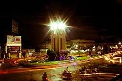 Clock tower at Anantapuramu | |
 Anantapuramu | |
| Coordinates: 14°40′48″N 77°35′56″E / 14.68°N 77.599°ECoordinates: 14°40′48″N 77°35′56″E / 14.68°N 77.599°E | |
| Country | India |
| State | Andhra Pradesh |
| District | Anantapur |
| Area[1] | |
| • Total | 56.98 km2 (22.00 sq mi) |
| Elevation | 335 m (1,099 ft) |
| Population (2011) | |
| • Total | 361,006 |
| • Density | 6,300/km2 (16,000/sq mi) |
| Languages | |
| • Official | Telugu |
| Time zone | UTC+5:30 (IST) |
| PIN | 515001, 515002, 515003, 515004, 515005, 515006, 515007 |
| Telephone code | 08554 |
| Vehicle registration | AP–02 |
| Website |
anantapur |
Anantapur (officially:Anantapuramu[2]) is a city in Anantapur district of the Indian state of Andhra Pradesh. It is the mandal headquarters of Anantapuramu mandal and also the divisional headquarters of Anantapur revenue division.[3] The city is located on National Highway. It was also the headquarters of the Datta Mandalam (Rayalaseema districts of Andhra Pradesh and Bellary district of Karnataka) in 1799. It was also a position of strategic importance for the British Indian Army during the Second World War.
Geography
Anantapuramu is located at 14°41′N 77°36′E / 14.68°N 77.6°E.[4] It has an average elevation of 335 m (1,099 ft). It is located at a distance of 356 km from Hyderabad, 484 km from Vijayawada, and 210 km from Bangalore which is the closest international airport.
Climate
Anantapuramu has a semi-arid climate, with hot and dry conditions for most of the year. Summers start in late February and peak in May with average high temperatures around the 37 °C (99 °F) range. Anantapuramu gets pre-monsoon showers starting as early as March, mainly through north-easterly winds blowing in from Kerala. Monsoon arrives in September and lasts until early November with about 250 mm (9.8 in) of precipitation. A dry and mild winter starts in late November and lasts until early February; with little humidity and average temperatures in the 22–23 °C (72–73 °F) range. Total annual rainfall is about 22 in (560 mm).
| Climate data for Anantapuramu (1981–2010) | |||||||||||||
|---|---|---|---|---|---|---|---|---|---|---|---|---|---|
| Month | Jan | Feb | Mar | Apr | May | Jun | Jul | Aug | Sep | Oct | Nov | Dec | Year |
| Record high °C (°F) | 36.0 (96.8) |
39.4 (102.9) |
41.8 (107.2) |
43.2 (109.8) |
44.1 (111.4) |
43.1 (109.6) |
38.1 (100.6) |
38.9 (102) |
37.9 (100.2) |
37.8 (100) |
36.8 (98.2) |
33.8 (92.8) |
44.1 (111.4) |
| Average high °C (°F) | 31.0 (87.8) |
34.3 (93.7) |
37.6 (99.7) |
39.4 (102.9) |
39.2 (102.6) |
35.7 (96.3) |
33.8 (92.8) |
33.0 (91.4) |
33.1 (91.6) |
31.9 (89.4) |
30.3 (86.5) |
29.6 (85.3) |
34.1 (93.4) |
| Average low °C (°F) | 17.5 (63.5) |
19.4 (66.9) |
22.7 (72.9) |
25.8 (78.4) |
26.2 (79.2) |
25.0 (77) |
24.3 (75.7) |
23.9 (75) |
23.4 (74.1) |
22.5 (72.5) |
20.1 (68.2) |
17.7 (63.9) |
22.4 (72.3) |
| Record low °C (°F) | 11.2 (52.2) |
12.8 (55) |
13.4 (56.1) |
18.3 (64.9) |
18.8 (65.8) |
19.6 (67.3) |
20.8 (69.4) |
20.8 (69.4) |
19.3 (66.7) |
14.1 (57.4) |
10.0 (50) |
9.4 (48.9) |
9.4 (48.9) |
| Average rainfall mm (inches) | 1.3 (0.051) |
0.4 (0.016) |
9.4 (0.37) |
18.9 (0.744) |
53.0 (2.087) |
59.9 (2.358) |
66.0 (2.598) |
91.3 (3.594) |
133.6 (5.26) |
95.5 (3.76) |
38.7 (1.524) |
9.1 (0.358) |
577.2 (22.724) |
| Average rainy days | 0.1 | 0.2 | 0.4 | 1.3 | 2.9 | 3.2 | 4.6 | 5.3 | 6.9 | 6.4 | 3.0 | 0.6 | 34.9 |
| Source: India Meteorological Department (record high and low up to 2010)[5][6] | |||||||||||||
Demographics
As of 2011 census, Anantapuramu has a population of 361,006.The sex ratio was 995 females per 1000 males and 9% of the population was under 6 years old.[7] Effective literacy is 82%, male literacy is 89% and female literacy is 75%. Telugu is the official and widely spoken language. Whereas Urdu , Kannada and English are the other languages spoken in the city.[8]
Governance
Civic administration
Anantapuramu Municipal Corporation is the civic body of Anantapuramu.
Public utilities
Anantapuramu Drinking Water Supply Project and Sri Sathya Sai Central Trust have also step forward in supplying clean water and concentrated mainly on eradicating fluorosis.[9] The corporation supplies chlorinated water to the city from the summer storage tank located in the town.[10]
Transport
Anantapuramu is well connected to the nearby major cities with National Highway 7 and National Highway 205 of National Highway network of India. The NH–7 connects it to Bangalore and NH–205 connects it to Chennai via Renigunta.[11] The Andhra Pradesh State Road Transport Corporation operates bus services from Anantapur bus station.[12] The city has a total road length of 298.12 km.[13]
Anantapuramu provides rail connectivity for the city and is classified as an A–category station in Guntakal railway division of South Central Railway zone. The nearst International airport is Kempegowda International Airport, Bengaluru which is 210 kilometers away.
Culture
There are a few notable people from the town with their contributions to various fields such as politics, film industry and other areas. Neelam Sanjiva Reddy was the former President of India and the first Chief Minister of Andhra Pradesh, Paidi Lakshmayya was the first member of Parliament from Anantapur lok sabha constituency; Kallur Subba Rao was an Indian freedom activist and was the first speaker of Andhra Assembly; Kadiri Venkata Reddy was an Indian film director, writer and also a producer, Sathya Sai Baba, a Hindu spiritual leader; Bellary Raghava was an Indian playwright, thespian and film actor.
Cuisine
Millets such as, Jowar, Bajra, Ragi are the food grains which are mostly used in food items.[14]
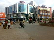
Cityscape
Neighbourhoods and landmarks in and around the city are :- Clock tower, Sapthagiri circle, ISKCON temple,[15] the railway station area, bus station, Srikantam circle, Government Hospital, Court Road etc.
Education
The primary and secondary school education is imparted by government, aided and private schools of the School Education Department of the state.[16][17] The medium of instruction followed by different schools are English, Telugu.
Anantapuramu is an important education centre of the district which has many schools, colleges and universities. Prominent institutions and universities include, Sri Krishnadevaraya University, JNTU Anantapur, Sri Sathya Sai University, Government Medical College, Arts College, Srinivasa Ramanujan Institute of Technology, PVKK Institute of Technology etc.
Sports
Anantapuramu has many sports facilities and has played host to Irani Cup in 1963–64 when Rest of India scored their lowest total of 83 against the then Ranji trophy winners Bombay, played at the Sanjeeva Reddy stadium. Several Ranji trophy matches and other regional tournaments for basketball, badminton, etc. have been hosted in Anantapur.
The Anantapuramu Sports Village (ASV), located alongside the National Highway 7. The Anantapuramu Cricket Ground sits within a 40-acre (160,000 m2) complex which is managed by the Rural Development Trust (RDT).[18] In October 2010, Rafael Nadal opened the Rafael Nadal Tennis School, which hosts district, state and national-level tournaments, as well as laying equal emphasis on the children's education and tennis training. There are several Indoor Stadiums for Basketball and Badminton under local bodies which conducts District, State and National Competitions. There are many Couching class for taekwondo and Karate. there are coaching centers for Swimming which conducts district competitions. [19][20]
Geographical directions
Destinations from Anantapuramu | |
|---|---|
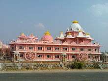
Temples
There are four temples under the management of Endowments Department[21].
- Sri Kasivisweswara & Kodanda Rama Swamy Temples
- Sri Virupakeshwara & Obuleswara Swamy Temple
- Sri Peta Basaveswara Swamy Temple
- Sri Rama Swamy temple
And there are several important Temples which became good landmarks such as
- ISKCON temple
- Shivakoti temple
- Harihara Temple
- Sri Anjanayaswamy Temple
See also
References
- ↑ "Municipalities, Municipal Corporations and UDAs" (PDF). Directorate of Town and Country Planning. Government of Andhra Pradesh. Retrieved 23 June 2016.
- ↑ "About Anantapuramu Municipal Corporation | Anantapuramu Municipal Corporation". anantapur.cdma.ap.gov.in. Retrieved 10 June 2017.
- ↑ "anantapuramu District Mandals" (PDF). Census of India. pp. 395, 435. Retrieved 19 January 2015.
- ↑ Falling Rain Genomics, Inc – Anantapuramu. Fallingrain.com. Retrieved on 3 September 2013.
- ↑ "Anantapur Climatological Table Period: 1981–2010". India Meteorological Department. Retrieved 12 May 2015.
- ↑ "Ever recorded Maximum and minimum temperatures up to 2010" (PDF). India Meteorological Department. Archived from the original (PDF) on 21 May 2013. Retrieved 12 May 2015.
- ↑ "Provisional Population Totals, Census of India 2011; Cities having population 1 lakh and above" (PDF). Office of the Registrar General & Census Commissioner, India. Retrieved 26 March 2012.
- ↑ "Census Digital Library". Open Government Data (OGD) Platform India. Retrieved 2017-02-13.
- ↑ "Anantapur Drinking Water Supply Project Anantapur Drinking Water Supply Project". Srisathyasai.org.in. Retrieved 27 February 2016.
- ↑ "Commissioner inspects summer storage tanks". The Hans India. Anantapur. 15 May 2009. Retrieved 27 February 2016.
- ↑ "NH wise Details of NH in respect of Stretches entrusted to NHAI" (PDF). National Highways Authority of India (NHAI). Retrieved 4 July 2008.
- ↑ "Bus Stations in Districts". Andhra Pradesh State Road Transport Corporation. Archived from the original on 22 March 2016. Retrieved 9 March 2016.
- ↑ "DETAILS OF ROADS IN EACH ULB OF ANDHRA PRADESH".
- ↑ Sarma, G. v Prasada (18 June 2016). "Plan to encourage millet consumption". The Hindu. Retrieved 14 October 2016.
- ↑ "ISKCON Temple ISKCON Temple". Andhra Pradesh Tourism. Retrieved 27 February 2016.
- ↑ "School Education Department" (PDF). School Education Department, Government of Andhra Pradesh. Archived from the original (PDF) on 19 March 2016. Retrieved 7 November 2016.
- ↑ "The Department of School Education – Official AP State Government Portal | AP State Portal". www.ap.gov.in. Archived from the original on 7 November 2016. Retrieved 7 November 2016.
- ↑ The pride of Anantapur. sportstaronnet.com (21 March 2009). Retrieved on 3 September 2013.
- ↑ Rafa Nadal Foundation – Tennis. ATP World Tour. Retrieved on 3 September 2013.
- ↑ Welcome to the 'Nadal Tennis School'. NDTV.com Photo Gallery. Retrieved on 3 September 2013.
- ↑ "Trust Boards Abstract". AP Temples Portal, Government of Andhra Pradesh. Retrieved 24 July 2018.
External links
| Wikimedia Commons has media related to Anantapur, Andhra Pradesh. |

- Anatapur district
Template:Anantapuramu district
| Authority control |
|---|