An Khê District
Coordinates: 14°00′00″N 108°34′59″E / 14.000°N 108.583°E
| An Khê | |
|---|---|
| District-level town (Class-4) | |
| Country |
|
| Region | Central Highlands |
| Province | Gia Lai Province |
| Capital | An Khê |
| Area | |
| • Total | 77 sq mi (199 km2) |
| Population (2003) | |
| • Total | 63,118 |
| Time zone | UTC+7 (UTC + 7) |
An Khê is a town (thị xã) of Gia Lai Province in the Central Highlands region of Vietnam.
As of 2003 the district had a population of 63,118.[1] The district covers an area of 199 km². The district capital lies at An Khê.[1]
Located on the main highway, QL-19 between Qui Nhơn on the coast and Pleiku in the Central Highlands, An Khê was of strategic significance during the Vietnam War.
History
First Indochina War
An Khê was the seat of one of the latest battles of the First Indochinese War : the Battle of Mang Yang Pass. On Jun. 24, 1954, G.M. 100 received orders to abandon its defensive positions at An Khê and fall back to Pleiku, some 50 miles away over Route Coloniale 19. At the road marker 'Kilometer 15' the column was ambushed by Viet Minh troops belonging to the 803rd Regiment and suffered heavy losses.
Second Indochina War
In August 1965 the U.S. 1st Cavalry Division established their main base, Camp Radcliff at An Khê. In September of that year, the Battle of An Ninh took place about 30km east of the town of An Khê. Camp Radcliff remained in use by various U.S. Army units until late-1970 after which it was turned over to the ARVN.
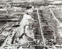 An Khê airfield 1965
References
- 1 2 "Districts of Vietnam". Statoids. Archived from the original on 1 March 2009. Retrieved March 13, 2009.
External links
- The short film STAFF FILM REPORT 66-2A (1966) is available for free download at the Internet Archive
- The short film STAFF FILM REPORT 66-8A (1966) is available for free download at the Internet Archive
- The short film STAFF FILM REPORT 66-20A (1966) is available for free download at the Internet Archive
- The short film STAFF FILM REPORT 66-21A (1966) is available for free download at the Internet Archive
| Đắk Lắk Province | 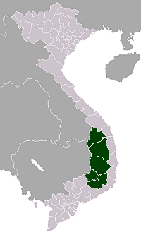 | |
|---|---|---|
| Đắk Nông Province | ||
| Gia Lai Province | ||
| Kon Tum Province | ||
| Lâm Đồng Province | ||
※ denotes provincial seat. | ||