Đức Trọng District
| Đức Trọng District Huyện Đức Trọng | |
|---|---|
| District | |
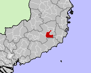 Location in Lâm Đồng Province | |
| Country |
|
| Region | Central Highlands |
| Province | Lâm Đồng |
| Capital | Liên Nghĩa |
| Area | |
| • Total | 348 sq mi (902 km2) |
| Population (2003) | |
| • Total | 161,232 |
| Time zone | UTC+7 (UTC + 7) |
Đức Trọng is a rural district (huyện) of Lâm Đồng Province in the Central Highlands region of Vietnam. Đức Trọng is located at the center of Lâm Đồng Province. Liên Nghĩa Town (Thị trấn), the District Capital, is 30 km away to the south of Da Lat. National Way no. 20 (Đà Lạt - Hồ Chí Minh City) and National Way no. 27 (Đà Lạt - Ban Mê Thuột) run through the district. It also has two highways connecting Đà Lạt and the Central coastal provinces.[1]
The District is subdivided into one town (Liên Nghĩa) and 13 communes (xã): Hiệp Thạnh, Hiệp An, Liên Hiệp, Bình Thạch, N'Thôn Hạ, Tân Hội, Tân Thành, Phú Hội, Ninh Gia, Tà Hine, Ninh Loan, Đà Loan, and Tà Năng.
Pongour Waterfall, well known as "Seven-Floor Fall" (Thác Bảy Tầng) or "the First Waterfall of the South" (Nam thiên đệ nhất thác) is an attractive tourist site of Đức Trọng.
As of 2003 the district had a population of 161,232.[2] The district covers an area of 902 km². The district capital lies at Liên Nghĩa.[2]
References
- ↑ http://www.dalat.gov.vn/thongtinxa/Default.aspx?alias=www.dalat.gov.vn/thongtinxa/ductrong
- 1 2 "Districts of Vietnam". Statoids. Retrieved March 13, 2009.
| Đắk Lắk Province |  | |
|---|---|---|
| Đắk Nông Province | ||
| Gia Lai Province | ||
| Kon Tum Province | ||
| Lâm Đồng Province | ||
※ denotes provincial seat. | ||
Coordinates: 11°41′50″N 108°18′58″E / 11.6972°N 108.3161°E