Kitscoty
| Kitscoty | ||
|---|---|---|
| Village | ||
| Village of Kitscoty | ||
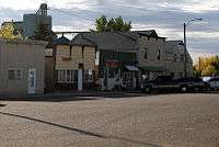 Main Street, Kitscoty | ||
| ||
| Nickname(s): Biggest Little Sports Centre in Alberta | ||
 Kitscoty | ||
| Coordinates: 53°20′14″N 110°19′59″W / 53.33722°N 110.33306°WCoordinates: 53°20′14″N 110°19′59″W / 53.33722°N 110.33306°W | ||
| Country |
| |
| Province |
| |
| Region | Central Alberta | |
| Census division | 10 | |
| Municipal district | County of Vermilion River | |
| Founded | 1905 | |
| Incorporated[1] | ||
| • Village | March 22, 1911 | |
| Government[2] | ||
| • Mayor | Daryl Frank | |
| • Governing body | Kitscoty Village Council | |
| Area (2016)[3] | ||
| • Land | 1.51 km2 (0.58 sq mi) | |
| Elevation[4] | 670 m (2,200 ft) | |
| Population (2016)[3] | ||
| • Total | 925 | |
| • Density | 610.9/km2 (1,582/sq mi) | |
| • Municipal census (2016) | 976[5] | |
| Time zone | UTC−7 (MST) | |
| • Summer (DST) | UTC−6 (MDT) | |
| Highways | Yellowhead Highway | |
| Website | Official website | |
The Village of Kitscoty in Alberta is situated at the junction of Highway 16 (Yellowhead Highway) and Highway 897 (the proposed link to Cold Lake). The village is located approximately midway between Edmonton and Saskatoon (225 km (140 mi) and 295 km (183 mi) respectively). In addition, the village is within short commuting distance of Lloydminster. The CN railway tracks also pass through Kitscoty. The surrounding County of Vermilion River's municipal office is located in Kitscoty.
Kitscoty is located in a prime agricultural area which has much heavy oil activity, both of which provide employment opportunities for the residents.
History

The first settlers came to the district in 1905, and was incorporated as a Village in 1911. Kitscoty originally served a trading area stretching from Cold Lake in the north to the Battle River in the south. Kitscoty is named after a famous cromlech, 3 large stones in a tripod arrangement, found near a settlement in England known as Kit's Coty House.[6]
Demographics
In the 2016 Census of Population conducted by Statistics Canada, the Village of Kitscoty recorded a population of 925 living in 317 of its 337 total private dwellings, a 9.3% change from its 2011 population of 846. With a land area of 1.51 km2 (0.58 sq mi), it had a population density of 612.6/km2 (1,586.6/sq mi) in 2016.[3]
The population of the Village of Kitscoty according to its 2016 municipal census is 976,[5] a 0.9% change from its 2013 municipal census population of 967.[7]
In the 2011 Census, the Village of Kitscoty had a population of 846 living in 300 of its 316 total dwellings, a 19.3% change from its 2006 population of 709. With a land area of 1.54 km2 (0.59 sq mi), it had a population density of 549.4/km2 (1,422.8/sq mi) in 2011.[8]
Education
There is an elementary school and a junior/senior high school within the village.
See also
References
- ↑ "Location and History Profile: Village of Kitscoty" (PDF). Alberta Municipal Affairs. October 21, 2016. p. 414. Retrieved October 23, 2016.
- ↑ Alberta Municipal Affairs: Municipal Officials Search
- 1 2 3 "Population and dwelling counts, for Canada, provinces and territories, and census subdivisions (municipalities), 2016 and 2011 censuses – 100% data (Alberta)". Statistics Canada. February 8, 2017. Retrieved February 8, 2017.
- ↑ "Alberta Private Sewage Systems 2009 Standard of Practice Handbook: Appendix A.3 Alberta Design Data (A.3.A. Alberta Climate Design Data by Town)" (PDF) (PDF). Safety Codes Council. January 2012. pp. 212–215 (PDF pages 226–229). Retrieved October 8, 2013.
- 1 2 "2016 Municipal Affairs Population List" (PDF). Alberta Municipal Affairs. ISBN 978-1-4601-3127-5. Retrieved January 29, 2017.
- ↑ Ronaghan, Allen (1973). Earnest-Minded Men : an account of local government in the County of Vermilion River. Kitscoty, Alberta: County of Vermilion River. p. 191.
- ↑ "2015 Municipal Affairs Population List" (PDF). Alberta Municipal Affairs. ISBN 978-1-4601-2630-1. Retrieved January 29, 2017.
- ↑ "Population and dwelling counts, for Canada, provinces and territories, and census subdivisions (municipalities), 2011 and 2006 censuses (Alberta)". Statistics Canada. February 8, 2012. Retrieved February 8, 2012.
External links
- Official website


Places adjacent to Kitscoty | |
|---|---|