Al-Bireh
| Al-Bireh | ||
|---|---|---|
| Other transcription(s) | ||
| • Arabic | البيرة | |
| • Also spelled | al-Bira (unofficial) | |
 | ||
| ||
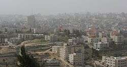
 Al-Bireh Location of Al-Bireh within Palestine | ||
| Coordinates: 31°54′19″N 35°12′54″E / 31.90528°N 35.21500°ECoordinates: 31°54′19″N 35°12′54″E / 31.90528°N 35.21500°E | ||
| Palestine grid | 170/145 | |
| Governorate | Ramallah & al-Bireh | |
| Government | ||
| • Type | City | |
| • Head of Municipality | Umar Hammayil | |
| Area | ||
| • Jurisdiction | 22,406 dunams (22.4 km2 or 8.6 sq mi) | |
| Population (2006) | ||
| • Jurisdiction | 38,202 | |
| Name meaning | "The Well of the Palace"[1] | |
| Website | www.al-bireh.org | |
Al-Bireh, al-Birah, or el-Bira (Arabic: البيرة; also known historically as Castrum Mahomeria, Magna Mahomeria, Mahomeria Major, Birra, or Beirothah) is a Palestinian city in the central West Bank, 15 kilometers (9.3 mi) north of Jerusalem.[2] It is situated on the central ridge running through the West Bank and is 860 meters (2,820 ft) above sea level, covering an area of 22.4 square kilometers (8.6 sq mi).
Because of its location Al-Bireh served as an economic crossroad between the north and south, along the caravan route between Jerusalem and Nablus. According to the Palestinian Central Bureau of Statistics (PCBS), the city had a population of approximately 39,202 in the 2007 census.[3]
History
Edward Robinson in the early 19th century thought Al-Bireh was the biblical Be'eroth,[5] but modern scholars believe Be'eroth was located at Kh. el-Burj near Beit Iksa.[6]
Claude Reignier Conder and others identified it with Beirothah of the Samaritan chronicles.[6][7]
The Crusaders captured and named the town Birra. It was also called Castrum Mahomeria, Magna Mahomeria or Mahomeria Major.[8] It was one of 21 villages given by King Godfrey as a fief to the Church of the Holy Sepulchre.[9] In 1114, the gift was re-confirmed by Baldwin I of Jerusalem.[10]
In 1156, 92 people from Mahomeria pledged their allegiance to the Church of the Holy Sepulchre, and a further 50 names were added in the next three decades. Hence, it has been estimated that the total Frankish population at this time was 500-700.[8][11]
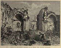
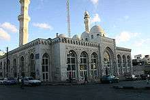
The Crusaders built a castle,[12] church and hospice there.[8][13][14] The latter two buildings were built by the Knights Templar in 1146 and belonged to the Church of the Holy Sepulchre. The Ayyubids under Saladin drove away the Crusaders from Birra when they reconquered interior Palestine after the Battle of Hattin in 1187, and completely demolished the town. Yaqut al-Hamawi mentions seeing the ruins a few times during his travels in the area.[15] Nearing the end of Ayyubid rule, in 1280, the modern town of al-Bireh was an inhabited village. The Ayyubids built a mosque in the town dedicated to Umar ibn al-Khattab adjacent to the church ruins.[16]
Potsherds from the Crusader/Ayyubid era have been found.[6]
Ottoman era
Al-Bireh, like the rest of Palestine, was incorporated into the Ottoman Empire in 1517, and in the census of 1596 the village, called Bira al-Kubra, was a part of the nahiya ("subdistrict") of Al-Quds which was under the administration of the liwa ("district") of Al-Quds. It had a population of 45 households, all Muslim, and paid taxes on wheat, barley, olive trees, fruit trees, occasional revenues, beehives and/or goats.[17]
In the spring of 1697, Henry Maundrell noted at Al Bireh, which he called Beer, the remains of a Church, which he wrote was built by Empress Helena.[18]
After the 1834 Arab revolt in Palestine, the Ottoman authorities conscripted many men from Al-Bireh as soldiers. In 1838, when Robinson visited, 60 had been taken away to be soldiers, out of a total population of 700.[5]
When French explorer Victor Guérin visited the village in 1863, he found it to have 800 inhabitants.[19]
Socin, citing an official Ottoman village list compiled around 1870, noted that Al-Bireh had a population of 399 Muslims in 142 houses, and 20 "Greeks" in 5 houses, though that population count included men, only. It was further noted that the name meant "The cistern".[20] Hartmann found that Al-Bireh had 142 houses.[21]
In 1883, the Palestine Exploration Fund's Survey of Western Palestine described Bireh as a good-sized village, with "fairly well built" houses.[22]
In 1896 the population of Bireh was estimated to be about 1,080 persons.[23]
Until 1917, the city served as a political and administrative center for the Ottoman Empire.
British Mandate era
In the 1922 census of Palestine conducted by the British Mandate authorities, Al-Bireh had a population of 1,479; 1,407 Muslims, and 72 Christians,[24] increasing at the time of the 1931 census to 2,292, 2044 Muslim and 248 Christians, in 541 houses.[25]
In 1945, the town's residents numbered 2,920, of which 280 were Christians and 2,640 Muslims,[26] while urban Bireh had 967 dunams of land, and rural Bireh 22,045 dunams, according to an official land and population survey.[27] Of this, 5,162 dunams were plantations and irrigable land, 11,226 used for cereals,[28] while 759 dunams were built-up (urban) land.[29]
1948-1967
In the wake of the 1948 Arab–Israeli War and the 1949 Armistice Agreements, Al-Bireh came under Jordanian rule.[30]
Post-1967 era
On June 6, 1967, Israeli troops occupied the city in the Six-Day War. In 1994, the civil administration of the city was turned over to the Palestinian National Authority under the Oslo Accords. Al-Bireh is the second largest center of Palestinian administration after Gaza. Besides the governor’s headquarters, it also hosts a considerable number of governmental, non-governmental, and private organizations, including the Ministries of Transportation, Supply, Information, Public Works and Higher Education, as well as the Palestine Broadcasting Corporation and the Palestinian Central Bureau of Statistics.[31] Due to its proximity with Ramallah, the cities form a single constituency for elections to the Palestinian National Authority.
Demographics
The 1997 census carried out by the Palestinian Central Bureau of Statistics counted 27,856 residents, of which the gender distribution was exactly half male and half female.[32] The majority of the inhabitants were Palestinian refugees who made up 55.4% of the total population.[33] In the 2007 PCBS census, there were 38,202 people living in the city.[34]
Al-Bireh is inhabited by five major clans: Quraan, Abed, Hamayyel, Tawil, and Karakra. Rafidi, a Christian family, was accepted into the Tawil clan.
Government
Al-Bireh established a city council headed by mayor Eid Musa in 1928 under the British Mandate. Eight other mayors took office either through elections or government appointments. The city had some well known mayors, including Abudul Jawad Saleh who was mayor in the 1970s until exiled by the Israelis. He later went on to become a member of the PLO executive committee and then minister of agriculture in the Palestinian Authority. In 1982, Israel instated a civil administration, but later appointed an Arab mayor, Hassan al-Tawil. In 1988, after two years in office, he was stabbed and critically wounded outside his office.[35] In 1996, a 12-member municipal council was established by the Palestinian National Authority with Sheikh Jamal al-Tawil as mayor.[36]
In the Palestinian municipal elections in 2005, the Hamas-backed Reform and Change List won 9 of the 15 seats, while independent lists won the remaining 6.[37] The current mayor is Umar Hammayil. Al-Bireh, located in Area A, is under the complete control of the PNA.
In 2010, a public square in al-Bireh was dedicated to the memory of Dalal Mughrabi, leader of an attack that killed 38 Israeli civilians, including 13 children, in 1978.[38]
Health and education
In 2010, the Jerusalem Fund, National Arab American Medical Association Foundation and Physicians for Peace dedicated the Palestine Diabetes Institute in al-Bireh.[39] Al-Quds University maintains a campus in al-Bireh.
Sports
The 7,000-seat Majed Ass'ad or Al Bireh International Stadium was completed in 2010; originally constructed in 1996, it was upgraded to international standards from 2006 to 2010 at a cost of €3 million.[40] The work was funded by France, the German Development Bank, the UN Development Agency, and FIFA.[41] Construction was halted by the Israeli Supreme Planning Council on November 1, 2009, but resumed in late December.[42] In November 2009, the nearby settlement of Psagot petitioned the High Court of Justice to have the stadium shut down, citing concerns that rowdy soccer fans might attack Psagot.[43]
The Palestinian Center for Judo, Karate and Aerobics is located in al-Bireh.[44]
Sister cities
Notable people
- Ahmad Sa'adat, PFLP secretary-general currently imprisoned in Israel[45]
- Bassel al-Araj, Palestinian activist killed in al-Bireh
References
- ↑ Palmer, 1881, p. 292
- ↑ Al Bireh City Archived 2012-04-05 at the Wayback Machine.
- ↑ 2007 PCBS Census. Palestinian Central Bureau of Statistics. p. 114.
- ↑ Wilson, c1881, vol 1, p.215
- 1 2 Robinson and Smith, 1841, pp. 130 - 133
- 1 2 3 Finkelstein et al., 1997, p. 510
- ↑ Conder, 1876, p. 196
- 1 2 3 Pringle, 1993, pp. 161 - 165
- ↑ Conder and Kitchener, 1883, SWP III, p. 11
- ↑ de Roziére, 1849, p. 263, cited in Röhricht, 1893, RRH, pp. 16 - 17, No 74
- ↑ de Roziére, 1849, pp. 242 -244, cited in Röhricht, 1893, RRH, pp. 77 - 78, No 302
- ↑ Pringle, 1997, p. 35
- ↑ Conder and Kitchener, 1883, SWP III, pp. 88-89
- ↑ Pringle, 2009, pp. 259 - 266
- ↑ le Strange, 1890, p. 423
- ↑ Sharon, 1999, pp. 236-239
- ↑ Hütteroth and Abdulfattah, 1977, p. 116
- ↑ Maundrell, 1703, p. 63: March 25, 1697, cited in Wilson, c1881, vol 1, p. 218
- ↑ Guérin, 1869, pp. 7-13
- ↑ Socin, 1879, p. 148
- ↑ Hartmann, 1883, p. 127
- ↑ Conder and Kitchener, 1883, SWP III, pp. 8-9
- ↑ Schick, 1896, p. 121
- ↑ Barron, 1923, p. 16
- ↑ Mills, 1932, p. 48
- ↑ Department of Statistics, 1945, p. 26
- ↑ Government of Palestine, Department of Statistics. Village Statistics, April, 1945. Quoted in Hadawi, 1970, p. 64
- ↑ Government of Palestine, Department of Statistics. Village Statistics, April, 1945. Quoted in Hadawi, 1970, p. 111
- ↑ Government of Palestine, Department of Statistics. Village Statistics, April, 1945. Quoted in Hadawi, 1970, p. 161
- ↑ The Encyclopedia of the Arab-Israeli Conflict: A Political, Social, and Military History, p. 73
- ↑ General view of al-Bireh Archived 2008-06-20 at the Wayback Machine. Al-Bireh Municipality.
- ↑ Palestinian Population by Locality, Sex and Age Groups in Years Archived 2008-11-19 at the Wayback Machine. Palestinian Central Bureau of Statistics.
- ↑ Palestinian Population by Locality and Refugee Status Archived 2008-11-19 at the Wayback Machine. Palestinian Central Bureau of Statistics.
- ↑ 2007 PCBS Census. Palestinian Central Bureau of Statistics. p.114.
- ↑ Israeli-Selected Arab Mayor Is Stabbed, The New York Times
- ↑ History of City Council Archived 2006-06-28 at the Wayback Machine.
- ↑ Local Elections (Round Four)- Successful lists by local authority and No. of votes obtained Central Elections Commission - Palestine.
- ↑ Palestinians Honor a Figure Reviled in Israel as a TerroristThe New York Times.
- ↑ The Jerusalem Fund Dedicates Palestine Diabetes Institute in Al-Bireh, Palestine
- ↑ Municipal Development & Lending Fund. "MDLF has completed "Al Bireh International Stadium" project Funded by AFD". 21 April 2010. Archived from the original on 25 April 2012. Retrieved 31 October 2010.
- ↑ B'Tselem (25 November 2009). "Civil Administration chokes Palestinian construction". Archived from the original on 3 December 2010. Retrieved 31 October 2010.
- ↑ "Al-Bireh stadium construction resumed under specter of halt". Ma'an News Agency. 31 December 2009. Retrieved 31 October 2010.
- ↑ Hass, Amira (27 November 2009). "Settlers petition to tear down nearby Palestinian stadium". Ha'aretz. Archived from the original on 21 November 2010. Retrieved 31 October 2010.
- ↑ They teach Al-Bireh residents how to get a kick out of life, Jerusalem Post
- ↑ Barghouti, Ze'evi assassin among prisoners to be freed
Bibliography
- Barron, J. B., ed. (1923). Palestine: Report and General Abstracts of the Census of 1922. Government of Palestine.
- Conder, C. R. (1876). "Samarian Topography". Quarterly statement - Palestine Exploration Fund. 8: 182–197.
- Conder, Claude Reignier; Kitchener, H. H. (1883). The Survey of Western Palestine: Memoirs of the Topography, Orography, Hydrography, and Archaeology. 3. London: Committee of the Palestine Exploration Fund.
- Department of Statistics (1945). Village Statistics, April, 1945. Government of Palestine.
- Finkelstein, Israel; Lederman, Zvi, eds. (1997). Highlands of many cultures. Tel Aviv: Institute of Archaeology of Tel Aviv University Publications Section. ISBN 965-440-007-3.
- Guérin, Victor (1869). Description Géographique Historique et Archéologique de la Palestine (in French). 1: Judee, pt. 3. Paris: L'Imprimerie Nationale.
- Guérin, Victor (1874). Description Géographique Historique et Archéologique de la Palestine (in French). 2: Samarie, pt. 1. Paris: L'Imprimerie Nationale. (p. 205)
- Hadawi, Sami (1970). Village Statistics of 1945: A Classification of Land and Area ownership in Palestine. Palestine Liberation Organization Research Centre.
- Hartmann, M. (1883). "Die Ortschaftenliste des Liwa Jerusalem in dem türkischen Staatskalender für Syrien auf das Jahr 1288 der Flucht (1871)". Zeitschrift des Deutschen Palästina-Vereins. 6: 102–149.
- Hütteroth, Wolf-Dieter; Abdulfattah, Kamal (1977). Historical Geography of Palestine, Transjordan and Southern Syria in the Late 16th Century. Erlanger Geographische Arbeiten, Sonderband 5. Erlangen, Germany: Vorstand der Fränkischen Geographischen Gesellschaft. ISBN 3-920405-41-2.
- Maundrell, Henry (1703). A Journey from Aleppo to Jerusalem: At Easter, A. D. 1697. Oxford: Printed at the Theatre.
- Mills, E., ed. (1932). Census of Palestine 1931. Population of Villages, Towns and Administrative Areas. Jerusalem: Government of Palestine.
- Palmer, E. H. (1881). The Survey of Western Palestine: Arabic and English Name Lists Collected During the Survey by Lieutenants Conder and Kitchener, R. E. Transliterated and Explained by E.H. Palmer. Committee of the Palestine Exploration Fund.
- Pringle, Denys (1993). The Churches of the Crusader Kingdom of Jerusalem: Volume I A-K (excluding Acre and Jerusalem). Cambridge University Press. ISBN 0 521 39036 2.
- Pringle, Denys (1997). Secular buildings in the Crusader Kingdom of Jerusalem: an archaeological Gazetter. Cambridge University Press. ISBN 0521 46010 7.
- Pringle, Denys (2009). The Churches of the Crusader Kingdom of Jerusalem: Volume IV The cities of Acre and Tyre with Addenda and Corrigenda to Volumes I-III. Cambridge University Press. ISBN 978-0-521-85148-0.
- Robinson, Edward; Smith, Eli (1841). Biblical Researches in Palestine, Mount Sinai and Arabia Petraea: A Journal of Travels in the year 1838. 2. Boston: Crocker & Brewster.
- Robinson, Edward; Smith, Eli (1856). Biblical Researches in Palestine and adjacent regions: A Journal of Travels in the years 1838 and 1852, 2nd edition. 3. London: John Murray. (p. 76)
- Robinson, Edward; Smith, Eli (1856). Later Biblical Researches in Palestine and adjacent regions: A Journal of Travels in the year 1852. London: John Murray. (pp. 429 + 340(?))
- Röhricht, Reinhold (1893). (RRH) Regesta regni Hierosolymitani (MXCVII-MCCXCI) (in Latin). Berlin: Libraria Academica Wageriana.
- de Roziére, ed. (1849). Cartulaire de l'église du Saint Sépulchre de Jérusalem: publié d'après les manuscrits du Vatican (in Latin and French). Paris: Imprimerie nationale.
- Schick, C. (1896). "Zur Einwohnerzahl des Bezirks Jerusalem". Zeitschrift des Deutschen Palästina-Vereins. 19: 120–127.
- Sharon, Moshe (1999). Corpus Inscriptionum Arabicarum Palaestinae, B-C. 2. BRILL. ISBN 90-04-11083-6.
- Socin, A. (1879). "Alphabetisches Verzeichniss von Ortschaften des Paschalik Jerusalem". Zeitschrift des Deutschen Palästina-Vereins. 2: 135–163.
- Strange, le, Guy (1890). Palestine Under the Moslems: A Description of Syria and the Holy Land from A.D. 650 to 1500. Committee of the Palestine Exploration Fund.
- de Vogüé, Melchior (1860). Les églises de la Terre Sainte. (pp. 338-339)
- Wilson, Charles Williams, ed. (c. 1881). Picturesque Palestine, Sinai and Egypt. 1. New York: D. Appleton.
External links
| Wikimedia Commons has media related to Al-Bireh. |
- Welcome To The City of al-Bira
- Survey of Western Palestine, Map 17: IAA, Wikimedia commons
- Al-Bira City (Fact Sheet), Applied Research Institute - Jerusalem (ARIJ)
- Al-Bira City City Profile, ARIJ
- Al-Bireh Municipality Website
- The Al-Bireh demonstration project on agricultural reuse of wastewater in the West Bank
