Silwad
| Silwad | |
|---|---|
| Other transcription(s) | |
| • Arabic | سلواد |
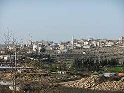 A view of Silwad from a hillside | |
 Silwad Location of Silwad within Palestine | |
| Coordinates: 31°59′10″N 35°15′33″E / 31.98611°N 35.25917°ECoordinates: 31°59′10″N 35°15′33″E / 31.98611°N 35.25917°E | |
| Palestine grid | 174/154 |
| Governorate | Ramallah & al-Bireh |
| Government | |
| • Type | Municipality |
| • Head of Municipality | Hajj Essa Hamed |
| Area | |
| • Jurisdiction | 18,792 dunams (18.8 km2 or 7.3 sq mi) |
| Elevation[1] | 851 m (2,792 ft) |
| Population (2006) | |
| • Jurisdiction | 6,123 |
| Name meaning | Selwad, personal name[2] |
Silwad (Arabic: سلواد) is a Palestinian town located north-east of Ramallah, about 5 km away from the Nablus-Jerusalem highway. Silwad's altitude is about 851 meters above sea level. According to the Palestinian Central Bureau of Statistics (PCBS), the town had a population of 6,123 inhabitants in 2007.[3]
Etymology
Historians have argued the etymology of Silwad's name. Some debated that it is derived from the words lisan and wad, meaning "tongue of the valley," as the town is surrounded by mountains from all sides, while the town appears as a tongue amidst the mountains. Others claim that "Silwad" comes from the words sal and wad, meaning "a running valley."[4]
Climate
The climate is Mediterranean-mountainous. Silwad experiences cold and humid winters with several days of snow almost every year with an average annual precipitation of about 750 millimeters (29.5 inches). The summers are dry and mild. This climate is suitable for growing cherries, nectarines, kiwifruit, peaches, grapes and olives.
Location
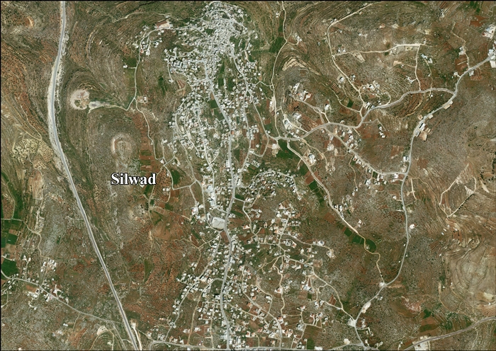
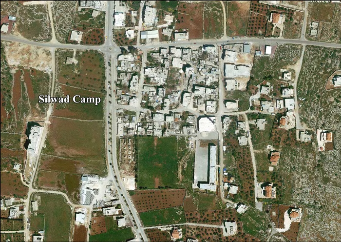
Silwad, which includes Silwad Camp, is located 10 kilometers (6.2 mi) (horizontally) northeast of Ramallah. It is bordered by Deir Jarir and Et Taiyiba to the east, Al Mazra'a ash Sharqiya and Jaljiliya to the north, Yabrud, Atara and Ein Siniya to the west and Ein Yabrud to the south.[1]
History
Silwad was inhabited in the Mamluk era.[5]
Ottoman era
Silwad was inhabited in the early Ottoman era.[5] In the spring of 1697, Henry Maundrell noted two "Arab villages," first "Geeb" and then "Selwid," both on the west side of the road on the way south from Nablus to Jerusalem.[6] Edward Robinson identified these two villages as Jibiya and Silwad.[7]
In 1838, Selwad was noted as a Muslim village in the District of Beni Murrah, north of Jerusalem.[8]
An Ottoman village list of about 1870 counted 205 houses and a population of 817 in Silwad, though the population count included men, only.[9][10]
In 1882, the Palestine Exploration Fund's Survey of Western Palestine described it as being situated on a hill, and having ancient tombs and a fine spring.[11]
In 1896 the population of Silwad was estimated to be about 1,845 persons.[12]
British Mandate era
In the 1922 census of Palestine conducted by the British Mandate authorities, Silwad had a population of 1,344, all Muslim,[13] increasing in the 1931 census to 1631 Muslims and 4 Christians, in a total of 380 houses.[14]
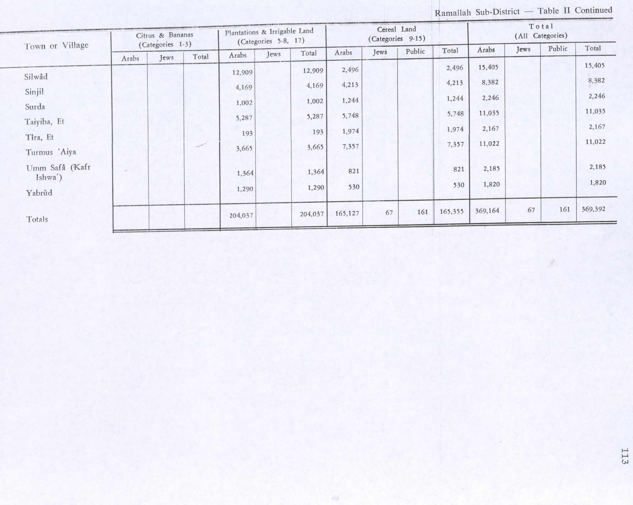
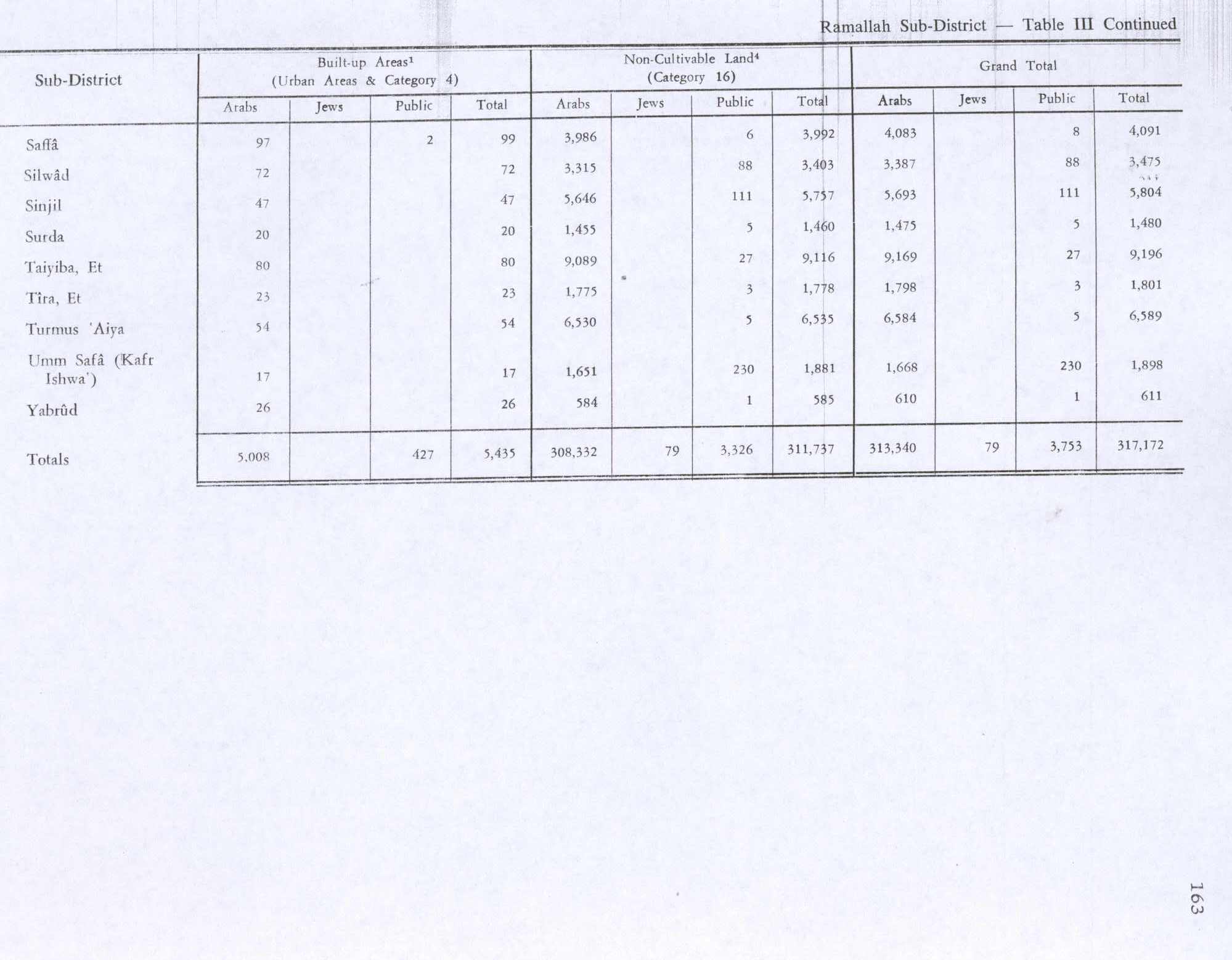
In the 1945 statistics the population was 1,910 Muslims,[15] while the total land area was 14,186 dunams, according to an official land and population survey.[16] Of this, 12,909 were plantations and irrigable land, 2,496 for cereals,[17] while 72 dunams were classified as built-up areas.[18]
Jordanian era
In the wake of the 1948 Arab–Israeli War, and after the 1949 Armistice Agreements, Silwad came under Jordanian rule.
Jordan confiscated lands of Silwad and nearby Ein Yabrud for the construction of a military camp before the Six-Day War.[19]
The Jordanian census of 1961 found 3,215 inhabitants.[20]
1967-present
After the Six-Day War in 1967, Silwad was under Israeli occupation. Only 1.7 % of village land belongs to Area A in the Oslo II Accord, while 37.7% is defined as Area B, and the remaining 60.6 % is Area C.[21][22]
The economy of Silwad is based on farming as well as handicrafts.
Land confiscation
The Jordanian buildings formed the initial basis of the Israeli settlement of Ofra founded in 1975.[19] Plans for further expansion of Ofra in this land in 2011 resulted in legal challenges and public dispute.[19] According to ARIJ, Israel has confiscated 988 dunams of land from Silwad for the construction of Ofra.[21]
Silwad villagers have petitioned the High Court to be allowed to farm their traditional lands to which they had been denied access for a decade. They requested the right to access to some 3,100 dunams, a quarter of Silwad's lands of which has been blocked by settlers. Land that has been blocked from cultivation in this way includes property of villagers from Taybeh, Ein Yabrud and Deir Jarir. The IDF blocked Silwad villagers from accessing their farming lands when under escort from peace activists; these lands cannot be entered directly from the village itself but only via the Israeli settlement of Ofra. The incident occurred after they had obtained permission to enter it, under escort from volunteers of Yesh Din.[23]
3 March 2002 incident
A 22-year-old Silwad bricklayer, Thaer Hamad, according to a local report, used his grandfather's WW2 Jordanian army bolt action Mauser and 30 rounds to fire from a nearby hill, at Wadi Haramiya on an Israeli checkpoint, near the settlements of Ofra and Shilo,[24] killing 7 soldiers and three civilian settlers.[25][26] He let one settler woman and her two children pass unharmed. He told one person of his deed, word leaked out and he was eventually arrested in October 2004, put on trial and sentenced to 11 life sentences. Thaer had seen one of his uncle's (Nabil Hammad), killed when he was a child,[24] during the First Intifada, and another shot dead by Israeli forces during the Al-Aqsa Intifada.[27][28][29][30] Robi Danelin, the mother of one of the dead soldiers, who said her son had served reluctantly in the West Bank, wrote a letter of reconciliation to Hamad's family. Her letter was rebuffed by Thaer, who brusquely dismissed what he described as an equation between casualties among soldiers in an army of occupation and martyrs killed in the course of their struggle for freedom.[27] The episode formed the basis for the plot of Najwa Najjar's 2014 film, Eyes of a Thief.[31]
24 October 2014 incident
Orwa Abd al-Wahhab Hammad (14[24]/17), a US citizen who came from New Orleans to the West Bank when he was 6, and was a cousin of Thaer Hamad,[24] was shot dead with a bullet to the neck which exited from his head[32][33] during a demonstration in the village, reportedly by an Israeli sniper. He was the second such teenager killed by IDF live fire in the West Bank in 8 days, the 10th since the beginning of 2014, adding to the total of 34 Palestinian victims of IDF gunfire at civilians in the West Bank since mid-June.[24][32][33] In various reports IDF sources state he was shot when he threw a bomb,[33] or that an adult was shot when he lit a molotov cocktail fuse and was readying himself to throw it on Route 60.[24][34][35] His cousin said he was among a group of rock-throwing Palestinians.[24]
Demographics
According to the estimates of Silwad Association in Jordan the population of the people of Silwad in Diaspora exceeds 25,000 (1996 estimates). Among these, 8,000 reside in Silwad.[36] There are about 8,000 Palestinians from Silwad in Kuwait, and there are also some in South America, especially Brazil.[37]
Notable people from Silwad
- Khaled Mashal, leader of Hamas
- Qadura Fares, Political leader of Fatah
References
- 1 2 Silwad Town Profile (including Silwad Camp), ARIJ, p. 4
- ↑ Palmer, 1881, p. 241
- ↑ 2007 PCBS Census. Palestinian Central Bureau of Statistics. p.113.
- ↑ Silwad.com Silwad history, in Arabic and English.
- 1 2 Finkelstein et. al. 1997, p. 572. Citing Kallai.
- ↑ Maundrell, 1703, p. 63: March 25, 1697
- ↑ Robinson and Smith,1841, vol 3, pp. 80-81
- ↑ Robinson and Smith, 1841, vol 3, Appendix 2, p. 125
- ↑ Socin, 1879, p. 161 It was described as being in the Beni Murra District.
- ↑ Hartmann, 1883, p. 115 also noted 205 houses
- ↑ Conder and Kitchener, SWP II, p. 291
- ↑ Schick, 1896, p. 122
- ↑ Barron, 1923, Table VII, Sub-district of Ramallah, p.17
- ↑ Mills, 1932, p. 54
- ↑ Government of Palestine, Department of Statistics, 1945, p. 26
- ↑ Government of Palestine, Department of Statistics. Village Statistics, April, 1945. Quoted in Hadawi, 1970, p. 65
- ↑ Government of Palestine, Department of Statistics. Village Statistics, April, 1945. Quoted in Hadawi, 1970, p. 113
- ↑ Government of Palestine, Department of Statistics. Village Statistics, April, 1945. Quoted in Hadawi, 1970, p. 163
- 1 2 3 State moves to expand settlement on Palestinian land confiscated by Jordan
- ↑ Government of Jordan, Department of Statistics, 1964, p. 14
- 1 2 Silwad town profile (including Silwad camp), ARIJ, p. 21
- ↑ "Btselem Map". Btselem.
- ↑ Amira Hass, 'IDF prevents Israeli activists from escorting Palestinians to their lands in West Bank,' at Haaretz, 2 August 2011.
- 1 2 3 4 5 6 7 Gili Cohen, Jack Khoury,'Palestinian-American teen killed by IDF gunfire during West Bank protest,' Haaretz 25 October 2014.
- ↑ Amos Harel,'Palestinian who killed 10 Israelis in shooting attack arrested,' Haaretz 5 October 2004:'the civilians Serge Botrov (Ariel); Vadim Balgulah, (Ariel) and Yitzhak Didi (Ofra).'
- ↑ Avi Issacharoff, 'The cumulative impact of sporadic West Bank terror,' The Times of Israel September 27, 2013.
- 1 2 Coby Ben-Simhon,'Forgiveness of dead IDF soldier's mother leaves Palestinian killer cold,' Haaretz 29 October 2009.
- ↑ Philip Weiss, 'The legend of the Silwad sniper,' Mondoweiss, 25 September 2010.
- ↑ 'Israel mourns as 10 fall to lone Palestinian sniper.Orthodox: Vengeance belongs to G-d,' Boston Globe, 4 March 2014.
- ↑ 'Sniper Killer of 11 Israeli Soldiers : Thaer Hamad's Father Interviewed,' Youtube, 22 February 2010.
- ↑ Eyal Sagui Bizawe, 'Palestinian cinema comes of age with ‘Eyes of a Thief’,' Haaretz 20 October 2014.
- 1 2 Allison Deger, 'Israeli army kills 14-year old Palestinian with U.S. citizenship', Mondoweiss 25 October 2014.
- 1 2 3 Isabel Kershner, 'Israeli Troops Kill Palestinian Teenager in the West Bank, the 2nd in 8 Days,' New York Times 24 October 2014.
- ↑ 'Israeli forces shoot, kill Palestinian teenager near Ramallah,' Ma'an News Agency 24 October 2014.
- ↑
- ↑ Silwad.com
- ↑ PALESTINE : Silwad, a History of Revolts
Bibliography
- Barron, J. B., ed. (1923). Palestine: Report and General Abstracts of the Census of 1922. Government of Palestine.
- Conder, C.R.; Kitchener, H. H. (1882). The Survey of Western Palestine: Memoirs of the Topography, Orography, Hydrography, and Archaeology. 2. London: Committee of the Palestine Exploration Fund.
- Finkelstein, I.; Lederman, Zvi, eds. (1997). Highlands of many cultures. 1. Tel Aviv: Institute of Archaeology of Tel Aviv University Publications Section. ISBN 965-440-007-3.
- Government of Jordan, Department of Statistics (1964). First Census of Population and Housing. Volume I: Final Tables; General Characteristics of the Population (PDF).
- Government of Palestine, Department of Statistics (1945). Village Statistics, April, 1945.
- Hadawi, S. (1970). Village Statistics of 1945: A Classification of Land and Area ownership in Palestine. Palestine Liberation Organization Research Centre.
- Hartmann, M. (1883). "Die Ortschaftenliste des Liwa Jerusalem in dem türkischen Staatskalender für Syrien auf das Jahr 1288 der Flucht (1871)". Zeitschrift des Deutschen Palästina-Vereins. 6: 102–149.
- Maundrell, H. (1703). A Journey from Aleppo to Jerusalem: At Easter, A. D. 1697. Oxford: Printed at the Theatre.
- Mills, E., ed. (1932). Census of Palestine 1931. Population of Villages, Towns and Administrative Areas. Jerusalem: Government of Palestine.
- Palmer, E. H. (1881). The Survey of Western Palestine: Arabic and English Name Lists Collected During the Survey by Lieutenants Conder and Kitchener, R. E. Transliterated and Explained by E.H. Palmer. Committee of the Palestine Exploration Fund.
- Robinson, E.; Smith, E. (1841). Biblical Researches in Palestine, Mount Sinai and Arabia Petraea: A Journal of Travels in the year 1838. 3. Boston: Crocker & Brewster.
- Schick, C. (1896). "Zur Einwohnerzahl des Bezirks Jerusalem". Zeitschrift des Deutschen Palästina-Vereins. 19: 120–127.
- Socin, A. (1879). "Alphabetisches Verzeichniss von Ortschaften des Paschalik Jerusalem". Zeitschrift des Deutschen Palästina-Vereins. 2: 135–163.
External links
- Welcome to the City of Silwad
- Silwad, Welcome to Palestine
- Survey of Western Palestine, Map 14: IAA, Wikimedia commons
- Silwad town (including Silwad camp) (fact sheet), Applied Research Institute–Jerusalem (ARIJ)
- Silwad town profile (including Silwad camp), ARIJ
- Silwad aerial photo, ARIJ
- Silwad camp aerial photo, ARIJ
- Silwad.com
- Deir Jarir & Silwad: Two Palestinian villages Hammered by the Israeli Occupation 15, March, 2008, POICA
