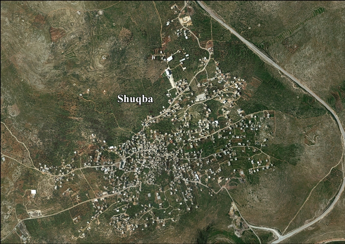
Shuqba
| Shuqba | |
|---|---|
| Other transcription(s) | |
| • Arabic | شقبه |
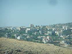 Roadside view of Shuqba, 2012 | |
 Shuqba Location of Shuqba within Palestine | |
| Coordinates: 31°59′13″N 35°2′18″E / 31.98694°N 35.03833°ECoordinates: 31°59′13″N 35°2′18″E / 31.98694°N 35.03833°E | |
| Palestine grid | 153/154 |
| Governorate | Ramallah & al-Bireh |
| Government | |
| • Type | Village council |
| Area | |
| • Jurisdiction | 13,390 dunams (13.4 km2 or 5.2 sq mi) |
| Population (2007) | |
| • Jurisdiction | 4,500 |
| Name meaning | The crevasse, cleft, or narrow pass.[1] |
Shuqba (Arabic: شقبة) is a Palestinian town in the Ramallah and al-Bireh Governorate, located 17 kilometers northwest of the city of Ramallah in Palestine.
Shuqba has a total area of 13,990 dunams, and the built-up area comprises 616 dunams.[2] Shuqba was home to approximately 4,497 inhabitants in 2007.[3]
Location
Shuqba is located 17,9 km northwest of Ramallah. It bordered by Deir abu Mash'al and Al-Itihad to the east, and Ni'lin, Qibya and Shabtin to the south.
To the west is the Green line, and to the north is 'Abud, Rantis,[4] and Israeli settlement of Ofarim.[2]
History
Dorothy Garrod studied the transition of Mesolithic to Neolithic culture represented in a cave on the northern bank of Wadi an-Natuf near Shuqba in 1928. The name "Natufian Culture" was then coined to describe the inhabitants of the southern Levant at this crucial juncture in human history.[5]
Sherds from Iron Age I-II, Iron Age II, Persian, Hellenistic, Roman Empire, Byzantine and Mamluk eras have been found.[6]
Ottoman era
Sherds from the early Ottoman era have been found here.[6] In 1596 Shuqba was a part of the nahiya ("subdistrict") of Ramla, which was under the administration Gaza Sanjak. In the tax records that year it had a population of 49 household who were all Muslims. They paid a fixed tax-rate of 25 % on agricultural products, including wheat, barley, summer crops, olive trees, goats and beehives, in addition to occasional revenues and a press for olives or grape syrup; a total of 2,600 akçe.[7]
In 1870, Victor Guérin noted that the houses of Kharbet Choukba were very roughly built; and that the village contained about two hundred inhabitants.[8] Under the name Schakba, an Ottoman village list of about the same year, 1870, found 39 houses and a population of 141, though the population count included men, only. It was noted that it was located north of Deir Qaddis, and having Bayt Nabala to the west.[9][10]
In 1882 the Palestine Exploration Fund's Survey of Western Palestine (SWP) described it as "A small village on high ground, surrounded with trees."[11]
British Mandate era
In the 1922 census of Palestine, conducted by the British Mandate authorities, Shuqba had a population of 530 Muslims,[12] increasing in the 1931 census to 696, still all Muslims, in a total of 130 houses.[13]
In the 1945 statistics, the population was 840, all Muslims,[14] while the total land area was 15,013 dunams, according to an official land and population survey.[15] Of this, 1,496 were allocated for plantations and irrigable land, 5,053 for cereals,[16] while 16 dunams were classified as built-up areas.[17]
Jordanian era
In the wake of the 1948 Arab–Israeli War, and after the 1949 Armistice Agreements, Shuqba came under Jordanian rule.
In 1961, the population of Shuqba was 1,241 persons.[18]
Post-1967
After the Six-Day War in 1967, Shuqba has been under Israeli occupation. The population in the 1967 census conducted by the Israeli authorities was 885, of whom 54 originated from the Israeli territory.[19]
After the 1995 accords, 8.4% of Shuqba land is defined as Area B land, while the remaining 91.6% is defined as Area C. The Segregation Wall is partly built on village land, and isolates 1,352 dunums (10%) of the village are on the west side of the wall. Israel has also confiscated village land for bypass roads and military checkpoints. In addition, an Israeli stone crusher was established on land owned by Palestinians, but confiscated by Israel. The extracted stone material is transferred to Israel, in breach of international law.[20][21]
References
- ↑ Palmer, 1881, p. 245
- 1 2 The Israeli fever of house demolition continues in Shuqba village Applied Research Institute - Jerusalem 2006-03-02
- ↑ 2007 PCBS Census. Palestinian Central Bureau of Statistics. p.113.
- ↑ Shuqba village profile, ARIJ, p. 4
- ↑ Elizabeth Knowles (2000), The Oxford Dictionary of Phrase and Fable, Oxford University Press, ISBN 0-19-860219-7, p. 728
- 1 2 Finkelstein et al., 1997, pp. 188–189
- ↑ Hütteroth and Abdulfattah, 1977, p. 154
- ↑ Guérin, 1875, p. 81
- ↑ Socin, 1879, p. 160
- ↑ Hartmann, 1883, p. 140 noted 38 houses
- ↑ Conder and Kitchener, 1882, SWP II, p. 298
- ↑ Barron, 1923, Table VII, Sub-district of Ramleh, p. 22
- ↑ Mills, 1932, p. 23.
- ↑ Government of Palestine, Department of Statistics, 1945, p. 30
- ↑ Government of Palestine, Department of Statistics. Village Statistics, April, 1945. Quoted in Hadawi, 1970, p. 68
- ↑ Government of Palestine, Department of Statistics. Village Statistics, April, 1945. Quoted in Hadawi, 1970, p. 117
- ↑ Government of Palestine, Department of Statistics. Village Statistics, April, 1945. Quoted in Hadawi, 1970, p. 167
- ↑ Government of Jordan, Department of Statistics, 1964, p. 24
- ↑ Perlmann, Joel (November 2011 – February 2012). "The 1967 Census of the West Bank and Gaza Strip: A Digitized Version" (PDF). Levy Economics Institute. Retrieved 24 June 2016.
- ↑ Shuqba village profile, ARIJ, pp. 16 –18
- ↑ Israeli stone quarries and crushers are founded on Palestinian private lands and do continuously expand January 8, 2016, POICA
Bibliography
- Barron, J.B., ed. (1923). Palestine: Report and General Abstracts of the Census of 1922. Government of Palestine.
- Conder, C.R.; Kitchener, H.H. (1882). The Survey of Western Palestine: Memoirs of the Topography, Orography, Hydrography, and Archaeology. 2. London: Committee of the Palestine Exploration Fund.
- Finkelstein, I.; Lederman, Zvi, eds. (1997). Highlands of many cultures. 1. Tel Aviv: Institute of Archaeology of Tel Aviv University Publications Section. ISBN 965-440-007-3.
- Government of Jordan, Department of Statistics (1964). First Census of Population and Housing. Volume I: Final Tables; General Characteristics of the Population (PDF).
- Government of Palestine, Department of Statistics (1945). Village Statistics, April, 1945.
- Guérin, V. (1875). Description Géographique Historique et Archéologique de la Palestine (in French). 2: Samarie, pt. 2. Paris: L'Imprimerie Nationale.
- Hadawi, S. (1970). Village Statistics of 1945: A Classification of Land and Area ownership in Palestine. Palestine Liberation Organization Research Center.
- Hartmann, M. (1883). "Die Ortschaftenliste des Liwa Jerusalem in dem türkischen Staatskalender für Syrien auf das Jahr 1288 der Flucht (1871)". Zeitschrift des Deutschen Palästina-Vereins. 6: 102–149.
- Hütteroth, Wolf-Dieter; Abdulfattah, Kamal (1977). Historical Geography of Palestine, Transjordan and Southern Syria in the Late 16th Century. Erlanger Geographische Arbeiten, Sonderband 5. Erlangen, Germany: Vorstand der Fränkischen Geographischen Gesellschaft. ISBN 3-920405-41-2.
- Mills, E., ed. (1932). Census of Palestine 1931. Population of Villages, Towns and Administrative Areas. Jerusalem: Government of Palestine.
- Palmer, E.H. (1881). The Survey of Western Palestine: Arabic and English Name Lists Collected During the Survey by Lieutenants Conder and Kitchener, R. E. Transliterated and Explained by E.H. Palmer. Committee of the Palestine Exploration Fund.
- Socin, A. (1879). "Alphabetisches Verzeichniss von Ortschaften des Paschalik Jerusalem". Zeitschrift des Deutschen Palästina-Vereins. 2: 135–163.
External links
- Welcome to Shuqba
- Survey of Western Palestine, Map 14: IAA, Wikimedia commons
- Shuqba (fact sheet), Applied Research Institute–Jerusalem (ARIJ)
- Shuqba village profile, (ARIJ)
- Shuqba (aerial photo), (ARIJ)
