Qibya
| Qibya | |
|---|---|
| Other transcription(s) | |
| • Arabic | قبية |
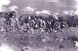 Villagers returning home after the 1953 massacre | |
 Qibya Location of Qibya within Palestine | |
| Coordinates: 31°58′39″N 35°00′35″E / 31.97750°N 35.00972°ECoordinates: 31°58′39″N 35°00′35″E / 31.97750°N 35.00972°E | |
| Palestine grid | 151/153 |
| Governorate | Ramallah & al-Bireh |
| Government | |
| • Type | Municipality |
| • Head of Municipality | Fahmi Makhtub |
| Area | |
| • Jurisdiction | 16,485 dunams (16.5 km2 or 6.4 sq mi) |
| Population (2007) | |
| • Jurisdiction | 4,901 |
| Name meaning | Domed[1] |
Qibya (Arabic: قبية) is a Palestinian village in the West Bank, located 30 kilometers (19 mi) northwest of Ramallah and exactly north of the large Israeli city of Modi'in. It is part of the Ramallah and al-Bireh Governorate, and according to the Palestinian Central Bureau of Statistics, it had a population of approximately 4,901 in 2007.[2]
Location
Qibya is located 19.9 kilometers (12.4 mi) (horizontally) northwest of Ramallah. It is bordered by Ni'lin to the east, Shuqba to the north, the Green line to the west, and Budrus and Ni'lin to the south.[3]
History
A Bar Kokhba Revolt coin dated to between 134 and 136 AD was found in a Karst cave near this village, suggesting that Jews who rebelled against the Roman Empire had found refuge in this cave.[4] Potsherds from the Roman/Byzantine, Byzantine Empire, Mamluk and early Ottoman period have been found in the village.[5]
Ottoman period
Qibya, like the rest of Palestine, was incorporated into the Ottoman Empire in 1517, and in the census of 1596, the village was located in the Nahiya of Ramla of the Liwa of Gaza. It had an entirely Muslim population of 29 households. They paid a fixed tax rate of 25% on wheat, barley, summer crops, olives, fruit trees, lintels, goats and/or beehives, in addition of taxes for a press for olives or grapes; a total of 6,000 Akçe.[6]
In 1882, the Palestine Exploration Fund's Survey of Western Palestine described the village (then named Kibbiah), as "a very small hamlet with olive-trees, on high ground".[7]
British Mandate period
In the 1922 census of Palestine, conducted by the British Mandate authorities, the village, (named Kibbia), had a population of 694 inhabitants, all Muslims.[8] In the 1931 census the population of Qibya was 909, still all Muslim, in 204 inhabited houses.[9]
In the 1945 statistics, the population of Qibya was 1,250, all Muslims,[10] who owned 16,504 dunams of land according to an official land and population survey.[11] 4,788 dunams were used for cereals,[12] while 32 dunams were built-up (urban) land.[13]
Jordanian era
In the wake of the 1948 Arab–Israeli War, and after the 1949 Armistice Agreements, Qibya came under Jordanian rule.
Massacre
In October 1953 Qibya was the target of an Israeli raid known as the Qibya massacre by Unit 101 commanded by Ariel Sharon which resulted in the death of 67 or 69 unarmed civilians and large-scale destruction of the village. On October 18, 1953, the U.S. State Department issued a bulletin expressing its "deepest sympathy for the families of those who lost their lives" in Qibya as well as the conviction that those responsible "should be brought to account and that effective measures should be taken to prevent such incidents in the future."[14] The United States temporarily suspended economic aid to Israel.
The Jordanian census of 1961 found 1,635 inhabitants in Qibya.[15]
Post-1967
Since the Six-Day War in 1967, Qibya has been under Israeli occupation. After the 1995 accords, 21.5% of Qibya land is defined as Area B land, while the remaining 78.5% is defined as Area C. Israel has confiscated land from Qibya in order to construct the Segregation Wall.[16]
Qibya received media coverage again in the run-up to the 2001 Israeli general election when it was correctly forecast that Sharon would become the next Israeli Prime Minister.[17]
References
- ↑ Palmer, 1881, p. 237
- ↑ 2007 PCBS Census Archived December 10, 2010, at the Wayback Machine.. Palestinian Central Bureau of Statistics. p.113.
- ↑ Qibya Village Profile, ARIJ, p. 4
- ↑ A Rare Bar Kochva Coin Was Discovered North to Modi'in
- ↑ Finkelstein et al, 1997, p. 174
- ↑ Hütteroth and Abdulfattah, 1977, p. 153
- ↑ Conder and Kitchener, 1882, SWP II, p. 297
- ↑ Barron, 1923, Table VII, Sub-district of Ramleh, p. 22
- ↑ Mills, 1932, p. 22
- ↑ Government of Palestine, Department of Statistics, 1945, p. 30
- ↑ Government of Palestine, Department of Statistics. Village Statistics, April, 1945. Quoted in Hadawi, 1970, p. 68
- ↑ Government of Palestine, Department of Statistics. Village Statistics, April, 1945. Quoted in Hadawi, 1970, p. 116
- ↑ Government of Palestine, Department of Statistics. Village Statistics, April, 1945. Quoted in Hadawi, 1970, p. 166
- ↑ The Department of State issued a statement on Oct. 18, 1953 (Department of State Bulletin, Oct. 26, 1953, p. 552).
- ↑ Government of Jordan, Department of Statistics, 1964, p. 24
- ↑ Qibya Village Profile, ARIJ, pp. 16-18
- ↑ Guardian From butcher to 'Lion' to Prime Minister of Israel by Jason Burke 4 February 2001
Bibliography
- Barron, J. B., ed. (1923). Palestine: Report and General Abstracts of the Census of 1922. Government of Palestine.
- Conder, C.R.; Kitchener, H. H. (1882). The Survey of Western Palestine: Memoirs of the Topography, Orography, Hydrography, and Archaeology. 2. London: Committee of the Palestine Exploration Fund.
- Finkelstein, I.; Lederman, Zvi, eds. (1997). Highlands of many cultures. Tel Aviv: Institute of Archaeology of Tel Aviv University Publications Section. ISBN 965-440-007-3.
- Government of Jordan, Department of Statistics (1964). First Census of Population and Housing. Volume I: Final Tables; General Characteristics of the Population (PDF).
- Government of Palestine, Department of Statistics (1945). Village Statistics, April, 1945.
- Hadawi, S. (1970). Village Statistics of 1945: A Classification of Land and Area ownership in Palestine. Palestine Liberation Organization Research Center.
- Hütteroth, Wolf-Dieter; Abdulfattah, Kamal (1977). Historical Geography of Palestine, Transjordan and Southern Syria in the Late 16th Century. Erlanger Geographische Arbeiten, Sonderband 5. Erlangen, Germany: Vorstand der Fränkischen Geographischen Gesellschaft. ISBN 3-920405-41-2.
- Mills, E., ed. (1932). Census of Palestine 1931. Population of Villages, Towns and Administrative Areas. Jerusalem: Government of Palestine.
- Palmer, E. H. (1881). The Survey of Western Palestine: Arabic and English Name Lists Collected During the Survey by Lieutenants Conder and Kitchener, R. E. Transliterated and Explained by E.H. Palmer. Committee of the Palestine Exploration Fund.
External links
- Welcome To Qibya
- Survey of Western Palestine, Map 14: IAA, Wikimedia commons
- Qibya Village (Fact Sheet), Applied Research Institute–Jerusalem (ARIJ)
- Qibya Village Profile, Applied Research Institute - Jerusalem (ARIJ)
- Qibya aerial photo, Applied Research Institute - Jerusalem (ARIJ)
- Locality Development Priorities and Needs in Qibya Village, Applied Research Institute - Jerusalem (ARIJ)
- Israel illegally Re delineate the boundaries of the Palestinian Villages! The case of Qibya and Budrus villages 17, October, 2005
- Halt-of-Construction orders hit Palestinian structures in the village of Qibya in Ramallah Governorate 23, December, 2010
- UN
