79th Street (IRT Broadway–Seventh Avenue Line)
79 Street | |||||||||
|---|---|---|---|---|---|---|---|---|---|
|
| |||||||||
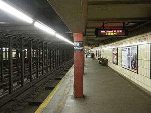 Downtown platform | |||||||||
| Station statistics | |||||||||
| Address |
West 79th Street & Broadway New York, NY 10024 | ||||||||
| Borough | Manhattan | ||||||||
| Locale | Upper West Side | ||||||||
| Coordinates | 40°47′02″N 73°58′48″W / 40.784°N 73.98°WCoordinates: 40°47′02″N 73°58′48″W / 40.784°N 73.98°W | ||||||||
| Division | A (IRT) | ||||||||
| Line | IRT Broadway–Seventh Avenue Line | ||||||||
| Services |
1 2 | ||||||||
| Transit connections |
| ||||||||
| Structure | Underground | ||||||||
| Platforms | 2 side platforms | ||||||||
| Tracks | 4 | ||||||||
| Other information | |||||||||
| Opened | October 27, 1904[1] | ||||||||
| Station code | 312[2] | ||||||||
| Wireless service |
| ||||||||
| Traffic | |||||||||
| Passengers (2017) |
5,102,655[4] | ||||||||
| Rank | 91 out of 425 | ||||||||
| Station succession | |||||||||
| Next north |
86th Street: 1 | ||||||||
| Next south |
72nd Street: 1 | ||||||||
| |||||||||
| |||||||||
| |||||||||
|
| |||||||||
|
79th Street Subway Station (IRT) | |||||||||
| MPS | New York City Subway System MPS | ||||||||
| NRHP reference # | 04001018[5] | ||||||||
| Added to NRHP | September 17, 2004 | ||||||||


79th Street is a local station on the IRT Broadway–Seventh Avenue Line of the New York City Subway. Located at the intersection of 79th Street and Broadway on the Upper West Side of Manhattan, it is served by the 1 train at all times and 2 train during late nights.
History
79th Street opened as part of the original subway on October 27, 1904, with service from Brooklyn Bridge to 145th Street. Subsequent extensions changed this routing to trains running down the entirety of the West Side of Manhattan with branches to Brooklyn, Harlem, and the Bronx.
Station layout
| G | Street Level | Exit/Entrance |
| P Platform level |
Side platform, doors will open on the right | |
| Northbound local | ← ← | |
| Northbound express | ← | |
| Southbound express | → | |
| Southbound local | → → | |
| Side platform, doors will open on the right | ||
Like other local stations, 79th Street has four tracks and two side platforms. The two local tracks are used by 1 trains at all times, and the two express tracks are used by the 2 train during daytime hours and the 3 at all times. At this point on the line, the center express tracks are slightly lower than the local tracks, particularly at the north end.
Exits
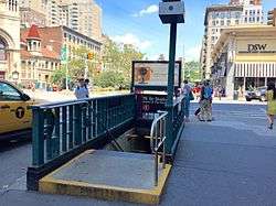
All fare control areas are on platform level and there are no crossovers or crossunders. The southbound platform is fully staffed, containing a turnstile bank, token booth, staircase going up to the northwest corner of West 79th Street and Broadway, and passageway separated from the platform by a steel fence leading to a staircase that goes up to the southwest corner of the aforementioned intersection. This passageway has a High Entry-Exit Turnstile to the platform and was added after the station's opening as proven by its cinder block tiles.[6]
The northbound platform's fare control is unstaffed, containing a turnstile bank, now-closed customer assistance booth, staircase going up to the southeast corner of West 79th Street and Broadway, and passageway separated from the platform by a steel fence leading to a staircase that goes up to the northeast corner of the aforementioned intersection. This passageway has a High Exit-Only Turnstile to the platform and was also added after the station's opening.[6]
Design and artwork
Both platforms have cream-colored tiles and a pink trim line with "79TH ST" written on it in black sans serif font at regular intervals. These tilings were installed during a 1970s renovation that covered most of the original mosaics and cartouches. Some of these as well as the decorated ceiling beams can still be seen by the fare control areas.
Gallery
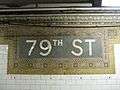 Name in mosaics
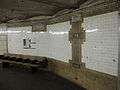 Original wall decorations and mosaics
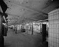 The uptown platform and control area in 1978
References
- ↑ "Our Subway Open: 150,000 Try It". The New York Times. October 28, 1904.
- ↑ "Station Developers' Information". Metropolitan Transportation Authority. Retrieved June 13, 2017.
- ↑ "NYC Subway Wireless – Active Stations". Transit Wireless Wifi. Retrieved May 18, 2016.
- ↑ "Facts and Figures: Annual Subway Ridership 2012–2017". Metropolitan Transportation Authority. July 12, 2018. Retrieved July 12, 2018.
- ↑ "NPS Focus". National Register of Historic Places. National Park Service. Retrieved November 6, 2011.
- 1 2 "MTA Neighborhood Maps: Upper West Side" (PDF). mta.info. Metropolitan Transportation Authority. 2015. Retrieved December 30, 2016.
External links
| Wikimedia Commons has media related to 79th Street (IRT Broadway – Seventh Avenue Line). |
- nycsubway.org – IRT West Side Line: 79th Street
- Station Reporter – 1 Train
- Forgotten NY – Original 28 - NYC's First 28 Subway Stations (Part 2)
- 79th Street entrance from Google Maps Street View
- Platforms from Google Maps Street View
| Topics |   | |
|---|---|---|
| Lists by county |
| |
| Lists by city | ||
| Other lists | ||
| ||