45th parallel north

45°
45th parallel north

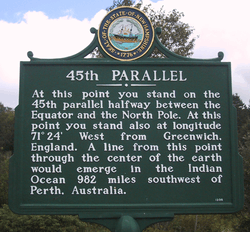
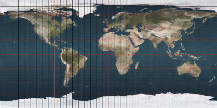
The 45th parallel north is a circle of latitude that is 45 degrees north of Earth's equator. It crosses Europe, Asia, the Pacific Ocean, North America, and the Atlantic Ocean. The 45th parallel north is often called the halfway point between the Equator and the North Pole, but the true halfway point is actually 16.2 km (10.1 mi) north of the 45th parallel because Earth is an oblate spheroid; that is, it bulges at the equator and is flattened at the poles.[1]

At this latitude, the Sun is visible for 15 hours 37 minutes during the summer solstice, and 8 hours 46 minutes during the winter solstice. The midday Sun stands 21.6° above the southern horizon at the December solstice, 68.4° at the June solstice, and exactly 45.0° at either equinox.[2]

Around the world

Starting at the Prime Meridian and heading eastwards, the parallel 45° north passes through:

Co-ordinates Country, territory
or sea
Notes
45°0′N 0°0′E / 45.000°N 0.000°E / 45.000; 0.000 (Prime Meridian)  France Aquitaine
Midi-Pyrénées
Limousin
Auvergne
Rhône-Alpes – passing just south of Grenoble
Provence-Alpes-Côte d'Azur
45°0′N 6°44′E / 45.000°N 6.733°E / 45.000; 6.733 (Italy)  Italy Piedmont – passing just south of Turin
Lombardy - passing by Voghera
Emilia-Romagna – passing just south of Piacenza
Lombardy
Veneto – passing just south of Rovigo
45°0′N 12°27′E / 45.000°N 12.450°E / 45.000; 12.450 (Adriatic Sea) Adriatic Sea Gulf of Venice
45°0′N 13°44′E / 45.000°N 13.733°E / 45.000; 13.733 (Croatia)  Croatia Istrian Peninsula, islands of Cres and Krk, and the mainland again
45°0′N 15°46′E / 45.000°N 15.767°E / 45.000; 15.767 (Bosnia and Herzegovina)  Bosnia and Herzegovina
45°0′N 18°44′E / 45.000°N 18.733°E / 45.000; 18.733 (Croatia)  Croatia
45°0′N 19°6′E / 45.000°N 19.100°E / 45.000; 19.100 (Serbia)  Serbia Passing through the centre of Ruma and through northern part of Sremska Mitrovica
Passing through the northern edge of Stara Pazova, 30 kilometres NW of Belgrade
45°0′N 21°24′E / 45.000°N 21.400°E / 45.000; 21.400 (Romania)  Romania Passing just north of Ploieşti and just south of Târgu Jiu
45°0′N 29°39′E / 45.000°N 29.650°E / 45.000; 29.650 (Black Sea) Black Sea
45°0′N 33°36′E / 45.000°N 33.600°E / 45.000; 33.600 (Ukraine)  Ukraine Crimea (claimed and controlled by  Russia) – passing just north of Simferopol, and just south of Feodosiya
45°0′N 35°24′E / 45.000°N 35.400°E / 45.000; 35.400 (Black Sea) Black Sea
45°0′N 37°13′E / 45.000°N 37.217°E / 45.000; 37.217 (Russia)  Russia Passing just south of Krasnodar, and just south of Stavropol
45°0′N 47°15′E / 45.000°N 47.250°E / 45.000; 47.250 (Caspian Sea) Caspian Sea
45°0′N 51°4′E / 45.000°N 51.067°E / 45.000; 51.067 (Kazakhstan)  Kazakhstan Mangystau Province
45°0′N 56°0′E / 45.000°N 56.000°E / 45.000; 56.000 (Uzbekistan)  Uzbekistan Karakalpakstan (autonomous republic) – including Vozrozhdeniya Island in the Aral Sea
45°0′N 59°50′E / 45.000°N 59.833°E / 45.000; 59.833 (Kazakhstan)  Kazakhstan Kyzylorda Province
South Kazakhstan Province
Zhambyl Province
Almaty Province
45°0′N 80°2′E / 45.000°N 80.033°E / 45.000; 80.033 (China)  People's Republic of China Xinjiang
45°0′N 93°13′E / 45.000°N 93.217°E / 45.000; 93.217 (Mongolia)  Mongolia Govi-Altai Province
Bayankhongor Province
Övörkhangai Province
Dundgovi Province
Dornogovi Province
45°0′N 111°46′E / 45.000°N 111.767°E / 45.000; 111.767 (China)  People's Republic of China Inner Mongolia
45°0′N 112°31′E / 45.000°N 112.517°E / 45.000; 112.517 (Mongolia)  Mongolia Sükhbaatar Province
45°0′N 114°7′E / 45.000°N 114.117°E / 45.000; 114.117 (China)  People's Republic of China Inner Mongolia
Jilin
Heilongjiang
45°0′N 131°30′E / 45.000°N 131.500°E / 45.000; 131.500 (Russia)  Russia Primorsky Krai
45°0′N 136°37′E / 45.000°N 136.617°E / 45.000; 136.617 (Sea of Japan) Sea of Japan Passing just south of Rishiri Island,  Japan
45°0′N 141°41′E / 45.000°N 141.683°E / 45.000; 141.683 (Japan)  Japan Hokkaidō
45°0′N 142°32′E / 45.000°N 142.533°E / 45.000; 142.533 (Sea of Okhotsk) Sea of Okhotsk
45°0′N 147°31′E / 45.000°N 147.517°E / 45.000; 147.517 (Kuril Islands) Kuril Islands Island of Iturup, administered by  Russia, claimed by  Japan
45°0′N 147°59′E / 45.000°N 147.983°E / 45.000; 147.983 (Pacific Ocean) Pacific Ocean
45°0′N 124°1′W / 45.000°N 124.017°W / 45.000; -124.017 (United States)  United States Oregon
Idaho
Montana
Montana / Wyoming border (approximate)
South Dakota
Minnesota – passing through Minneapolis
Wisconsin – passing through a 45×90 point (halfway between the North Pole and the Equator, and halfway between the Prime Meridian and the 180th meridian)
45°0′N 87°37′W / 45.000°N 87.617°W / 45.000; -87.617 (Lake Michigan) Lake Michigan Green Bay – territorial waters of the United States
45°0′N 87°21′W / 45.000°N 87.350°W / 45.000; -87.350 (United States)  United States WisconsinDoor Peninsula
45°0′N 87°9′W / 45.000°N 87.150°W / 45.000; -87.150 (Lake Michigan) Lake Michigan Territorial waters of the United States
45°0′N 86°9′W / 45.000°N 86.150°W / 45.000; -86.150 (United States)  United States MichiganSouth Manitou Island
45°0′N 86°5′W / 45.000°N 86.083°W / 45.000; -86.083 (Lake Michigan) Lake Michigan Territorial waters of the United States
45°0′N 85°46′W / 45.000°N 85.767°W / 45.000; -85.767 (United States)  United States MichiganLeelanau Peninsula (Leelanau County)
45°0′N 86°5′W / 45.000°N 86.083°W / 45.000; -86.083 (Lake Michigan) Lake Michigan Grand Traverse Bay – territorial waters of the United States
45°0′N 85°47′W / 45.000°N 85.783°W / 45.000; -85.783 (United States)  United States Michigan (Antrim County, Otsego County, Montmorency County, and Alpena County)
45°0′N 83°26′W / 45.000°N 83.433°W / 45.000; -83.433 (Lake Huron) Lake Huron Territorial waters of the United States and Canada
45°0′N 81°27′W / 45.000°N 81.450°W / 45.000; -81.450 (Canada)  Canada OntarioBruce Peninsula
45°0′N 81°11′W / 45.000°N 81.183°W / 45.000; -81.183 (Lake Huron) Lake Huron Georgian Bay – territorial waters of Canada
45°0′N 79°59′W / 45.000°N 79.983°W / 45.000; -79.983 (Canada)  Canada Ontario
45°0′N 74°54′W / 45.000°N 74.900°W / 45.000; -74.900 (United States)  United States New York – for about 10 km
45°0′N 74°46′W / 45.000°N 74.767°W / 45.000; -74.767 (Canada)  Canada OntarioCornwall Island
Quebec – running just north of the border with New York,  United States
45°0′N 73°54′W / 45.000°N 73.900°W / 45.000; -73.900 (United States)  United States New York – running just south of the border with Quebec,  Canada
Vermont – running just south of the border with Quebec,  Canada
New Hampshire
Maine
45°0′N 67°4′W / 45.000°N 67.067°W / 45.000; -67.067 (Passamaquoddy Bay) Passamaquoddy Bay
45°0′N 67°0′W / 45.000°N 67.000°W / 45.000; -67.000 (Canada)  Canada Deer Island, New Brunswick
45°0′N 66°57′W / 45.000°N 66.950°W / 45.000; -66.950 (Bay of Fundy) Bay of Fundy Territorial waters of Canada
45°0′N 65°10′W / 45.000°N 65.167°W / 45.000; -65.167 (Canada)  Canada Nova Scotia
45°0′N 61°57′W / 45.000°N 61.950°W / 45.000; -61.950 (Atlantic Ocean) Atlantic Ocean
45°0′N 1°12′W / 45.000°N 1.200°W / 45.000; -1.200 (France)  France Aquitaine – passing just north of Bordeaux

North America

The 45th parallel approximately defines most of the border between Montana and Wyoming in the United States.
The 45th parallel approximately defines part of the international border between Quebec, Canada, and New York and Vermont, United States.
Marker on Interstate 5 near Keizer, Oregon.
45th parallel marker in Roseville, Minnesota

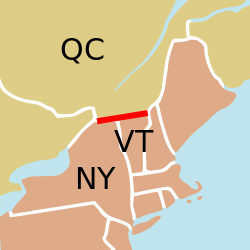
In North America, the 45th parallel forms some boundaries, and passes through the U.S. states of Oregon, Idaho, South Dakota, Minnesota, Wisconsin, Michigan, New York, Vermont, New Hampshire and Maine and through the Canadian provinces of Ontario, Quebec, New Brunswick and Nova Scotia.

All of mainland New Brunswick lies north of the 45th parallel. The southernmost point in mainland New Brunswick, just north of the 45th parallel, is Greens Point, approximately 90 kilometres (56 mi) west of Saint John. Approximately two-thirds of Deer Island, plus all of Campobello and Grand Manan islands, are south of the 45th parallel.

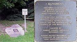
The parallel roughly bisects mainland Nova Scotia. Halifax is approximately 40 km (25 mi) south of the parallel.

The 45th parallel roughly marks the national border between the United States and Canada between the St. Lawrence and Connecticut rivers (the northern borders of the U.S. states of New York and Vermont with the Canadian province of Quebec), where the parallel is sometimes called the "Canada line". The actual boundary of Vermont lies approximately 1 kilometre (3,300 ft) north of the parallel due to an error in the 1772 survey.[3]

In Michigan, the Old Mission Peninsula in Grand Traverse Bay ends just shy of the 45th parallel. Many guidebooks and signs at the Mission Point Lighthouse describe it as being halfway between the equator and north pole. When the Grand Traverse Bay recedes below normal level, it is possible to walk out to the exact line.

Farther west, the line roughly bisects the metropolitan area of Minneapolis-St. Paul. In the Western United States, the parallel passes through the Great Plains and Rocky Mountains, intersecting the Pacific coast in Oregon.

The 45th parallel makes up most of the boundary between Montana and Wyoming.

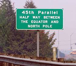
Throughout the United States the parallel is marked in many places on highways by a sign proclaiming that the location is halfway between the North Pole and the equator.[4][5]

Asia

Continuing west, the parallel passes over vast stretches of the North Pacific Ocean before passing through Rishiri-Rebun-Sarobetsu National Park and the adjacent town of Horonobe on the northern tip of Hokkaidō, the northernmost of Japan's main islands. It continues through the northern part of the Sea of Japan, entering the Asian mainland on the coast of Primorsky Krai in Russia, north of Vladivostok.

At Khanka Lake it enters northeast China, cutting across Heilongjiang and continuing through part of Jilin and eastern Inner Mongolia. Transecting southern Mongolia it passes through the provinces of Sükhbaatar, Dornogovi (and its capital Sainshand), Dundgovi, Övörkhangai, Bayankhongor, Govi-Altai, and Khovd. In northwest China it passes through the Ili Kazakh Autonomous Prefecture in Xinjiang and the oil city of Karamay.

The parallel passes through southern Kazakhstan, intersecting the city of Burylbaytal at the southern tip of Lake Balkhash and the city of Qyzylorda further west. At the border with Uzbekistan it bisects the Aral Sea and its toxic Vozrozhdeniya Island peninsula, site of an abandoned Soviet bioweapons laboratory. It skirts the northern edge of the Ustyurt Plateau, entering back into Kazakhstan before cutting across the northern tip of the Caspian Sea and into Europe and Russia.

Europe

Sundial at the 45th parallel in Senj, Croatia.

In Europe the 45th parallel stretches between the Caspian Sea coast of the Russian Caucasus in the east and Bay of Biscay coast of France in the west. In Russia it runs from the west coast of the Caspian Sea to the east coast of the Black Sea, through the Republic of Kalmykia, Stavropol Krai and its capital Stavropol, and Krasnodar Krai and its capital Krasnodar. In Ukraine it crosses the Crimea and its capital Simferopol.

Further west it passes through the Balkans: Romania (just north of Ploieşti, and through Târgu Jiu), the Serbian autonomous province of Vojvodina, the eastern tip of Croatia, the northern edge of Bosnia and Herzegovina, and a section of Adriatic Croatia. The capital city of SerbiaBelgrade is just south of the parallel.

In northern Italy it parallels the river Po, near Rovigo, passing by Voghera, then just south of Turin before passing into France in the Cottian Alps.

In France, it crosses the river Rhône at Pont-de-l'Isère, just north of Valence, Drôme and through Grenoble. It then continues across the Massif Central and into the Aquitaine region. The city of Bordeaux is just south of the parallel.

See also

References

  1. "The Half-Way to the Pole Line". 2 May 2006. Retrieved 16 July 2018.
  2. "Duration of Daylight/Darkness Table for One Year". aa.usno.navy.mil. Retrieved 16 July 2018.
  3. "The Canada-U.S. Border - Townships Heritage WebMagazine". townshipsheritage.com. Retrieved 19 April 2018.
  4. "Concord Monitor: "New Hampshire is halfway between the equator and the North Pole – just don't ask where"". concordmonitor.com. Retrieved 19 April 2018.
  5. Brown, K. Williams (July 10, 2011). "The beauty of halfwayism". Statesman Journal. Salem, Oregon. p. 5D. Retrieved July 9, 2018 via Newspapers.com.
This article is issued from Wikipedia. The text is licensed under Creative Commons - Attribution - Sharealike. Additional terms may apply for the media files.