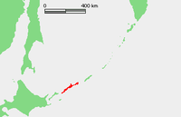
Iturup
| Disputed island Other names: Russian: Итуру́п; Japanese: 択捉島; Ainu:エツ゚ヲロプシㇼ | |
|---|---|
 NASA image of Iturup with Berutarube volcano at the southern end of the island | |
| Geography | |
 | |
| Location | Sea of Okhotsk |
| Coordinates | 45°02′N 147°37′E / 45.033°N 147.617°ECoordinates: 45°02′N 147°37′E / 45.033°N 147.617°E |
| Archipelago | Kuril Islands |
| Area | 3,139 square kilometres (776,000 acres) |
| Length | 200 kilometres (120 mi) |
| Width | 27 kilometres (17 mi) |
| Highest point |
|
| Administered by | |
| Russia | |
| Oblast | Sakhalin |
| Raion | Kurilsky District |
| Claimed by | |
| Japan | |
| Prefecture | Hokkaido |
| Russia | |
| Oblast | Sakhalin |
| Demographics | |
| Population | 7,500 (as of 2003) |
Iturup (Russian: Итуру́п and Oстров Итуру́п, Ostrov Iturup[1]; Ainu: エツ゚ヲロプシㇼ, Etuworop-sir; Japanese: 択捉島, Etorofu-tō,[2] historically also called Yetorup), is one of the Kuril Islands. It was formerly known as Staten Island.[3] It is the largest and northernmost island in the southern Kurils, ownership of which is disputed by Japan and Russia.
The island was Japanese territory until the end of the Second World War in 1945, when Soviet forces took possession of all the Kurils and forced out Japanese residents. The island is still claimed by Japan, which considers a site on Iturup to be its northernmost point.
Iturup is located near the southern end of the Kuril chain, between Kunashiri (19 km to the SW) and Urup (37 km to the NE). The town of Kurilsk, administrative center of Kurilsky District, is located roughly midway along its western shore.
Iturup and Urup are separated by the Vries Strait, named after Dutch explorer Maarten Gerritsz Vries, the first recorded European to explore the area.[4]
Geography
Iturup consists of volcanic massifs and mountain ridges. A series of a dozen calc-alkaline volcanoes running NE to SW form the backbone of the island, the highest being Stokap (1,634 m) in the central part of Iturup. The shores of the island are high and abrupt. The vegetation mostly consists of spruce, larch, pine, fir, and mixed deciduous forests with alder, lianas and Kuril bamboo underbrush. The mountains are covered with birch and Siberian Dwarf Pine scrub, herbaceous flowers (including Fragaria iturupensis, the Iturup strawberry) or bare rocks.
The island also contains some high waterfalls, such as the Ilya Muromets.
Rheniite, a rhenium sulfide mineral (ReS2), was discovered in active hot fumaroles on Kudriavy volcano and first described in 2004. In the field it was originally mistaken for molybdenite.[5]
History
Initially inhabited by the Ainu, Iturup was reached in 1661 by the Japanese Shichirobei and his fellows after they had drifted there. The island saw both a Russian settlement (late 18th century) and a Japanese garrison (1800) at the site of the present-day Kurilsk. In 1855 Iturup was ceded to Japan by the Treaty of Shimoda. Its name comes from the Ainu エツ゚ヲロプ (Etuworop), meaning "Place possessing [many] capes."
On 26 November 1941, a Japanese carrier fleet left Hitokappu Bay (now called Kasatka Bay[6]), on the eastern shore of Iturup, and sailed for an attack on the American base of Pearl Harbor.
In 1945, according to decisions of the Yalta Conference, it was occupied by the Soviet Union after Japan's defeat in World War II. The Japanese inhabitants were expelled to mainland Japan.[7] In 1956 the two countries agreed to restore diplomatic relations, but the peace treaty, as of 2017, has not been concluded due to the disputed status of Iturup and some other nearby islands.
A Soviet Anti-Air Defense (PVO) airfield, Burevestnik (English: storm-petrel), is located on the island and was until 1993 home for a number of Mikoyan-Gurevich MiG-23 fighter jets.[8] In 1968, Seaboard World Airlines Flight 253A was intercepted over the Kurils and forced to land at Burevestnik with 214 American troops bound for Vietnam. An older airfield, Vetrovoe, exists on the eastern part of the island and may have been used primarily by Japanese forces during World War II.
A new international airport, Iturup Airport, was opened in 2014, 7 kilometres (4.3 mi) east of Kurilsk. It was the first airport built from scratch in Russia's post-Soviet history. It has a 2.3 kilometres (1.4 mi) long and 42 metres (138 ft) wide runway and can receive Antonov An-74-200 aircraft. It also has a military use. The Burevestnik military airfield 60 kilometres (37 mi) to the south, in the past received civilian aircraft as well, but was often closed because of fog. Burevestnik is now a reserve airfield for the new airport.[9] On February 2, 2018, PBS NewsHour reported that Russia announced it is sending fighter planes to Iturup.[10] Su-35 aircraft landed on a reserve airfield on the island[11] in March 2018[12][13] and Su-35s were then deployed to Iturup airport on a trial basis in August 2018.[14]
Administratively the island belongs to the Sakhalin Oblast of the Russian Federation.
Gallery
- Iturup
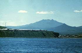 Volcanoes of Iturup
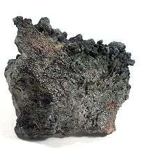 Rheniite crystals on a base of hardened lava, from Kudriavy Volcano
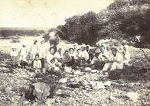 Japanese inhabitants of the island at a riverside picnic in 1933
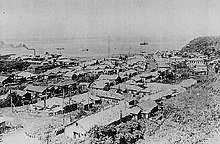 Shana Village in Etorofu (Shōwa period). There's a village hospital in the front, a factory in the left back with a fishery and a central radio tower (before 1945).
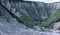 Iturup, 1981
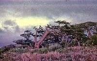 Trees showing effect of prevailing wind, 1981
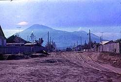 Kurilsk, 1981
See also
References
- ↑ "Ostrov Iturup: Russia". Geographical Names. Retrieved 2014-02-24.
- ↑ "Etorofu-tō: Russia". Geographical Names. Retrieved 2014-02-24.
- ↑ Heawood, Edward (1912). A history of geographical discovery in the seventeenth and eighteenth centuries. Cambridge: Cambridge University Press. p. 87.
- ↑ Dutch exploration Archived 2008-03-25 at the Wayback Machine.
- ↑ Korzhinsky, M.A.; Tkachenko, S. I.; Shmulovich, K. I.; Taran, Y. A.; Steinberg, G. S. (5 May 2004). "Discovery of a pure rhenium mineral at Kudriavy volcano". Nature. 369 (6475): 51–52. Bibcode:1994Natur.369...51K. doi:10.1038/369051a0.
- ↑ Внешняя политика Японии: сентябрь 1939 г.-декабрь 1941 г – 1959, page 246 (in Russian)
- ↑ Takahara, "Nemuro raid survivor"
- ↑ Austin, Greg; Muraviev, Alexey D. (2000). The Armed Forces of Russia in Asia. London: I.B.Tauris. p. 244. ISBN 9781860644856. Retrieved 16 June 2018.
- ↑ "New airport on Kuril Iturup Island receives first flight". Russia Beyond. Interfax. 22 September 2014. Retrieved 16 June 2018.
- ↑ "PBS NewsHour full episode February 2, 2018 (Time Index 8:37)". Retrieved 26 October 2014.
- ↑ "Japan Protests Russia's Military Flight Exercise Over Kuril Islands". Sputnik. March 28, 2018. Retrieved August 5, 2018.
- ↑ "Russian fighter jets land on disputed island". Xinhua News Agency. March 26, 2018. Retrieved August 5, 2018.
- ↑ Gady, Franz-Stefan (August 1, 2018). "Japan Asks Russia to Reduce Militarization of Disputed Kuril Islands". The Diplomat. Retrieved August 5, 2018.
- ↑ "Report: Fighter jets deployed on Etorofu for trial". NHK. August 4, 2018. Retrieved August 5, 2018.
External links
- Takahara, Kanako (September 22, 2007). "Nemuro raid survivor longs for homeland" (Newspaper article). Japan Times. Retrieved 2008-02-01.
- Google Maps
- Ocean Dots.com at the Wayback Machine (archived December 23, 2010)
- Sakhalin Oblast
| Islands | |
|---|---|
| Volcanoes |
|
| Other geographical features | |
| Cities and towns | |
| Events | |
| People | |
| |