Lake Khanka
| Lake Khanka Lake Xingkai о́зеро Ха́нка 兴凯湖 | |
|---|---|
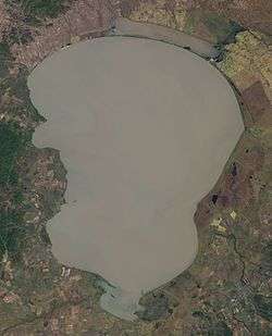 Landsat 7 image (2001) | |
| Location | Primorsky Krai, Russia / Heilongjiang, China |
| Coordinates | 45°0′N 132°25′E / 45.000°N 132.417°ECoordinates: 45°0′N 132°25′E / 45.000°N 132.417°E |
| Primary outflows | Songacha River |
| Basin countries | People's Republic of China, Russia |
| Max. length | 90 km (56 mi) [1] |
| Max. width | 45 km (28 mi) [1] |
| Surface area | 4,070 km2 (1,570 sq mi) [1] |
| Average depth | 4.5 m (15 ft) |
| Max. depth | 10.6 m (35 ft) |
| Water volume | 18.3 km3 (4.4 cu mi) [1] |
| Residence time | 9.9 yrs [1] |
| Shore length1 | 308 km (191 mi) [1] |
| Surface elevation | 68 m (223 ft) - 70 m (230 ft) |
| Frozen | December–April |
| Official name | Lake Khanka |
| Designated | 11 October 1976 |
| Reference no. | 112[2] |
| Official name | Xingkai Lake National Nature Reserve |
| Designated | 1 November 2002 |
| Reference no. | 1155[3] |
| 1 Shore length is not a well-defined measure. | |
Lake Khanka (Russian: о́зеро Ха́нка) or Lake Xingkai (simplified Chinese: 兴凯湖; traditional Chinese: 興凱湖; pinyin: Xīngkǎi Hú), is a freshwater lake on the border between Primorsky Krai, Russia and Heilongjiang province, Northeast China (at 45°0′N 132°25′E / 45.000°N 132.417°E).
Etymology
On the Delil map of 1706, the lake is named Himgon and from it flows a river with two signatures - Usurou and Ousuri.
On the map of Johann Matthias Hase 1739, the river flowing from Lake Hinka is called Ousoury and Schur.
On the map of d'Anville, in 1752, the lake also has the name Hink, but from the lake the Songhachan River flows into Usuri.
On the map of the 18th century "Irkutsk governorate with the adjacent islands and the western coast of America" from Lake Hinka follows the river Usuri.
On the map of 1860, attached to the Convention of Peking, two lakes are shown: the large "Oz. Khankai "with the second signature" Quiet ", but without the Manchu signatures, and a small lake" Oz. Dobiku "with the Manchurian signature. From the big lake flows a river, which has two signatures in Russian: "Uzhu" and "Sungachan", the second name has a signature in the Manchu language.
On the map of M. Popov in 1861, a large lake is called "Kengka" and the small one is called "Ai'-Kengka" and Siauhu is added in brackets, which can be understood as the transcription of the Chinese Xiaohu, that is, the Small Lake.
On the map of 1864 the captain of the case of the forest wardens of Budischeva the lake was named "Khinkai (Sinkai)".
On the ethnographic map of Shrenk are the signatures of the names "Oz. Khanka "and" Oz. Mal. Khanka. "[4]
The explorer, traveler and naturalist and writer Vladimir Arsenyev (1872-1930) wrote about the name of the lake: "In the Liao Dynasty, Khanka Lake was called Beitsin-hai, and now Khanka, Khinkai and Sinkai-hu, which means" Lake of Prosperity and Prosperity. " It must be assumed that the name of Lake Khanka originated from another word, namely from the word "khanhai", which means "hollow". By this name, the Chinese call every low place. " ... Subsequently, the Russians remade this word in Khanka. "
History of Lake Studies
Lake Khanka is an ancient lake, always rich in fish and poultry. One of the old names of it - "Khankai-Omo" - "Sea of bird feathers". Khankai fish was supplied in the Middle Ages on the tables of Chinese and Jurchen emperors.
In 1868 Nikolay Przhevalsky visited here, leaving for posterity the descriptions of the animal and plant world of these places.
In 1902, VK Arsen'ev made his first expedition to Khanka.
Physico-geographical characteristics
Lake Khanka, the largest lake in Primorsky Krai, is located in the center of the Khankan lowland on the border with the People's Republic of China in Heilongjiang Province. The northern part of the lake is in Chinese territory. The lake is pear-shaped, with an extension in its northern part. The surface area of the water is highly variable, depending on climate conditions. The maximum extension reaches 5,010 square kilometres (1,930 sq mi), the minimum extension is 3,940 square kilometres (1,520 sq mi). The length of the lake is about 90 kilometres (56 mi), the maximum width is 67 kilometres (42 mi). There are 24 rivers flowing into Lake Khanka, with only one outflow: Songacha River, which connects it with the Ussuri, and that in turn with the Amur River system.[5]
Lake Khanka is a shallow water body, with an average depth of 4.5 metres (15 ft) and a prevailing depth of 1–3 metres (3.3–9.8 ft); the greatest depth is 10.6 m (35 ft). Its average volume is 18.3 cubic kilometres (4.4 cu mi), though it can fill up to 22.6 km3 (5.4 cu mi)The water in the lake is cloudy, which is explained by frequent winds and, as a result, strong mixing. On average, the water inflow is about 1.94 cubic kilometres (0.47 cu mi) per year, and the outflow about 1.85 cubic kilometres (0.44 cu mi).[6]
On the northern (Chinese) shore, there is the Little Khanka lake (Chinese: 小兴凯湖, Xiaoxingkai Hu; Russian: о́зеро Малая Ха́нка, ozero Malaya Khanka), separated from Khanka by a narrow sandy spit.
Khanka Lake freezes in the second half of November and thaws in April.
The animal and plant world of Lake Khanka is diverse. In 1971, the Ramsar Convention gave the lake the status of a wetland of international importance. In 1990, the Khanka Nature Reserve was organized in part of the then-Soviet basin of Lake Khanka. In April 1996, an agreement was signed between the Governments of the Russian Federation and the People's Republic of China on the establishment of an international Russian-Chinese nature reserve around the lake, from the Khankai Reserve in Russia and the Chinese Sinkai-Hu Reserve.
The wetlands of the Lake Khanka basin (Водно-болотные угодья озера Ханка, Vodno-bolotnye ugod'ya ozera Khanka) represent a unique natural complex. The lowland of the Prihanka and, in fact, the shores of the lake represent a fairly swampy terrain. So-called melt-plant communities, formed by various species of sedge and grass, form a solid turf covering the water mirror for many tens of square kilometers. Diverse ecosystems are represented, such as meadows (from marshy to steppe), meadow forest, forest-steppe and steppe plant communities. In the lake itself there are many species of fish and aquatic invertebrates, many of which are endemic. In the lake there live 52 species of fish, among them such as carp, perch, silver carp, catfish, and snakehead. A variety of birds nest and stop on the lake or its banks.
The lake's drainage basin covers an area of 16,890 square kilometres (6,520 sq mi), of which 97% is in Russian territory. It is fed by 23 rivers (8 in China and 15 in Russia), but the only outflow of the lake is the Songacha River.[5]
The maximum monthly mean temperature is 20 °C (68 °F) in July, while the minimum monthly mean temperature is −21 °C (−6 °F) in January. Rainfall mainly occurs in summer, with average annual precipitation of 500–650 mm annually.[7]
The residence time of Lake Khanka is 9.9 years.[1]
Popular Culture: The surveyors in the 1975 Akira Kurosawa film "Dersu Uzala" were sent to explore the Lake Khanka region.
Biodiversity and environment
The lake is an important area for birds, and includes a number of endangered species.[8]
| Wikimedia Commons has media related to Lake Khanka. |
References
- 1 2 3 4 5 6 7 "Experience and Lessons Learned Brief for Lake Xingkai/Khanka" (PDF). Jin Xiangcan, Jiang Xia, Status and Prospects of the Russian-Chinese Cooperation in Environment Conservation and Water Management. Materials of the international conference, Moscow, MNR of Russia, 2007: 84. Archived from the original (PDF) on May 30, 2009.
- ↑ "Lake Khanka". Ramsar Sites Information Service. Retrieved 25 April 2018.
- ↑ "Xingkai Lake National Nature Reserve". Ramsar Sites Information Service. Retrieved 25 April 2018.
- ↑ Г. Левкин Сколько имен у Амура?
- 1 2 "Lake Profile: Khanka (Xingkai)". LakeNet. Retrieved 11 November 2012.
- ↑ Experience and Lessons Learned Brief for Lake Xingkai/Khank
- ↑ "Khanka Zapovednik -Climate" (in Russian). Ministry of Natural Resources and Environment (Russia). Retrieved May 13, 2016.
- ↑ "Lake Khanka". Russian Federation 2RU003. wetlands.org. Archived from the original on 12 February 2012. Retrieved 26 December 2012.
External links
| Five Great Lakes | ||
|---|---|---|
| Notable freshwater lakes |
| |
| Notable salt lakes | ||
| National Parks |
| |
| Protected wetlands | ||
| Nature Reserves | ||
| Major urban lakes | ||
| Reservoirs |
| |
Heilongjiang topics | |
|---|---|
| General | |
| Geography | |
| Education | |
| Visitor attractions | |
| |