Rapid City, South Dakota
Rapid City (Lakota: Mni Lúzahaŋ Otȟúŋwahe;[7] "Swift Water City") is the second most populous city in South Dakota in the US and the county seat of Pennington County.[8] Named after Rapid Creek, where the settlement developed, it is in the western part of the state, located on the eastern slope of the Black Hills mountain range. The population was 67,956 as of the 2010 Census.[9]
Rapid City, South Dakota | |
|---|---|
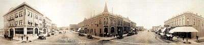
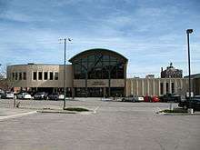
 Downtown Rapid City | |
| Nickname(s): Gateway to the Black Hills, City of Presidents | |
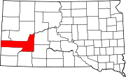
 Location in Pennington County and the state of South Dakota | |
 Rapid City, South Dakota Location in the United States | |
| Coordinates: 44.076°N 103.228°W | |
| Country | United States |
| State | South Dakota |
| County | Pennington |
| Founded | 1876[1] |
| Incorporated | February 1883[2] |
| Government | |
| • Mayor | Steve Allender |
| Area | |
| • City | 54.77 sq mi (141.85 km2) |
| • Land | 54.70 sq mi (141.69 km2) |
| • Water | 0.06 sq mi (0.16 km2) |
| Elevation | 3,202 ft (976 m) |
| Population | |
| • City | 67,956 |
| • Estimate (2018)[5] | 75,443 |
| • Rank | US: 469th |
| • Density | 1,379.09/sq mi (532.47/km2) |
| • Metro | 148,749 (US: 282nd) |
| Time zone | UTC−7 (Mountain) |
| • Summer (DST) | UTC−6 (Mountain) |
| Zip code | 57701, 57702, 57703, 57704, 57709 |
| Area code(s) | 605 |
| FIPS code | 46-52980 |
| GNIS feature ID | 1265333[6] |
| Website | Rapid City |
Known as the "Gateway to the Black Hills" due to its location and the "City of Presidents" because of the life-size bronze president statues located downtown, Rapid City is split by a low mountain ridge that divides the western and eastern parts of the city. Ellsworth Air Force Base is located on the outskirts of the city. Camp Rapid, a part of the South Dakota Army National Guard, is located in the western part of the city.
Rapid City is home to such popular attractions as Art Alley, Dinosaur Park, the City of Presidents walking tour, Chapel in the Hills, Storybook Island, Main Street Square, and more. The historic "Old West" town of Deadwood is nearby. In the neighboring Black Hills are the tourist attractions of Mount Rushmore, the Crazy Horse Memorial, Custer State Park, Wind Cave National Park, Jewel Cave National Monument, the museum at the Black Hills Institute of Geological Research, and to the east of the city is Badlands National Park.
History
The public discovery of gold in 1874 by the Black Hills Expedition, led by George Armstrong Custer, brought a mass influx of European-American miners and eventual settlers into this region of the Dakota Territory. Rapid City was founded in 1876 by a group of unsuccessful miners trying to create other chances; they promoted their new city as the "Gateway to the Black Hills"; it was originally known as "Hay Camp." The "Gateway" nickname is shared by neighboring Box Elder. In February 1876 John Richard Brennan and Samuel Scott, with a small group of men, laid out the site of the present Rapid City. It was eventually named for the spring-fed Rapid Creek that flows through it.
The land speculators measured off a square mile and designated the six blocks in the center as a business section. Committees were appointed to recruit prospective merchants and their families to locate in the new settlement. Such merchants soon began selling supplies to miners and pioneers. The city's location on the edge of the Plains and Hills and its large river valley made it a natural hub for the railroads that were constructed in the late 1880s from both the south and east. By 1900, Rapid City had survived a boom and bust and was developing as an important regional trade center for the upper Midwest.
Although the Black Hills had become popular in the late 1890s, this became a more important destination in the 20th century. Local entrepreneurs promoted the sights, the availability of the automobile for individual transportation, and construction of improved roadways after World War I, led to greatly increased numbers of tourists to this area. Gutzon Borglum, already a noted sculptor, began work on Mount Rushmore in 1927 and his son, Lincoln Borglum, continued the carving of the presidents' faces in rock following his father's death in 1941. The work was halted due to the US need to invest in buildup for its entry into World War II; the massive sculpture was declared complete in 1941. Although tourism had sustained the city throughout the Great Depression of the 1930s, the gasoline rationing of World War II decimated such travel. But investments in the defense industry and other war-related growth stimulated the placement of new military installations in the area, bringing more businesses and residents.
In 1930, the Rapid City Chamber of Commerce sent a letter inviting Al Capone to live in the Black Hills.[10] South Dakota's governor did not support the idea, and apparently neither did Capone, as he declined to relocate here.[10]
The city benefited greatly in the 1940s from the opening of Rapid City Army Air Base, later Ellsworth Air Force Base, an Army Air Corps training base. The population of the area nearly doubled between 1940 and 1948, from almost 14,000 to nearly 27,000 people. Military families and civilian personnel soon took every available living space in town, and mobile home parks proliferated. Rapid City businesses profited from the military payroll.
During the Cold War, the government constructed missile installations in the area: a series of Nike Air Defense sites were constructed around Ellsworth in the 1950s. In the early 1960s the construction of three Titan missile launch sites took place; these contained a total of nine Titan I missiles in the general vicinity of Rapid City. Beginning in November 1963, the land for a hundred miles east, northeast and northwest of the city was dotted with construction of 150 Minuteman missile silos and 15 launch command centers. These were all deactivated in the early 1990s.[11]
In 1949, city officials envisioned the city as a retail and wholesale trade center for the region. They developed a plan for growth that focused on a civic center, more downtown parking places, new schools, and paved streets. A construction boom continued into the 1950s. Growth slowed in the 1960s.
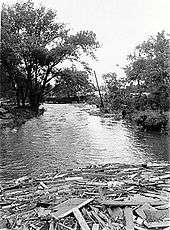
Following the worst natural disaster in South Dakota history, the Black Hills Flood of 1972, a building boom took place over the following decade to replace damaged structures. On June 9, 1972, heavy rains caused massive flash flooding along the course of Rapid Creek through the city. 238 people died and more than $100 million in property was destroyed.
In response to this devastation, the city received an outpouring of private donations and millions of dollars in federal aid. It was able to complete a major part of its 1949 plan: clearing the area along the Rapid Creek and making the floodplain a public park. In other areas, new homes and businesses were constructed to replace those that had been destroyed. Rushmore Plaza Civic Center and a new Central High School were built in part of the area that was cleared. The new Central High School opened in 1978, with the graduating class in that year attended classes in both the original Central (housed in what is now Rapid City High School and community theater) and the new Central.
The rebuilding generated construction and related jobs that in part insulated Rapid City from the drop in automotive tourism caused by the Oil Embargo in 1974, but tourism was depressed for most of a decade. In 1978, Rushmore Mall was built on the north edge of the city, adding to the city's position as a retail shopping center.
In 1980 in United States v. Sioux Nation of Indians, the Supreme Court of the United States ruled that the Federal government of the United States had illegally stolen the Black Hills from the Sioux people when the government unilaterally broke the treaty that guaranteed the Black Hills belonged to the Sioux. As a result of this ruling, the federal government offered a financial settlement, but the Lakota Sioux declined on principle: that the theft of their land should not be validated. They still demand the return of the land. The settlement funds accrue interest.[12] This land includes Rapid City, which is by far the largest modern settlement in the Black Hills. As of 2019, the dispute has not been settled.
In the 1980s, tourism increased again, as the city hosted the annual Sturgis Motorcycle Rally; another decline occurred in the late 1990s. Fears that Ellsworth AFB would be closed under the BRAC review and base closure process in the 1990s and 2000s led to attempts to expand other sectors of the economy. Growth continued and the city expanded significantly during this period.
Today, Rapid City is South Dakota's primary city for tourism and recreation. With the federal government's approval to authorize a Deep Underground Science and Engineering Laboratory at the Homestake Mine site in nearby Lead, Rapid City is primed for advancements in technology, medicine, and scientific research.
1972 Rapid Creek flood
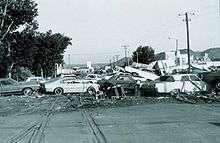
On June 9–10, 1972, extremely heavy rains over the eastern Black Hills of South Dakota produced record floods on Rapid Creek and other streams in the area. Nearly 15 inches (380 mm) of rain fell in about six hours near Nemo, and more than 10 inches (250 mm) of rain fell over an area of 60 square miles (160 km2). According to the Red Cross, the resulting peak floods (which occurred after dark) left 238 people dead and 3,057 people injured.[13] Total property destruction was estimated in excess of $160 million (about $964 million in 2018 dollars), which included 1,335 homes and 5,000 automobiles that were destroyed.
Runoff from this storm produced record floods (highest peak flows recorded) along Battle, Spring, Rapid, and Box Elder creeks. Smaller floods also occurred along Elk and Bear Butte creeks. Canyon Lake Dam, on the west side of Rapid City, broke the night of the flood, unleashing a wall of water down the creek. The 1972 flooding has an estimated recurrence interval of 500 years,[14] which means that a flood of this magnitude will occur on average once every 500 years. Every year there is a 0.2 percent chance (1 in 500) of a similar event occurring. To prevent similar damage, the city has prohibited residential and business construction on its flood plain. Today the flood plain is used for civic functions such as golf courses, parks, sports arenas, and arboretums, based mostly on the landscape and temporary use by people.
In 2007, the Rapid City Public Library created a 1972 Flood digital archive[15] that collects survivors' stories, photos and news accounts of the flood. The Journey Museum has an interactive display on the 1972 flood; this is an ongoing project to give future generations the best idea of how the people were affected and what changes the city made as a result of the major losses of life and property. Plans include the memorialization of all those who died from the flood by the preparation of individual biographies, so they may be remembered more fully.
Geography
Rapid City is located at 44.076188°N 103.228299°W. The downtown elevation of Rapid City is 3,202 feet (976 m). Rapid City is located in the shadow of Black Elk Peak, which at 7,242 feet (2,207 m), is the highest point east of the Rocky Mountains.
According to the United States Census Bureau, the city has a total area of 55.49 square miles (143.71 km2), of which 55.41 square miles (143.5 km2) is land and 0.08 square mile (0.2 km2) is water.[16]
Rapid City is located on the eastern edge of the Black Hills, and has developed on each side of the Dakota Hogback. Rapid City's "Westside" is located in the Red Valley between the foothills of the Black Hills proper and the Dakota Hogback, so named for the red Spearfish formation soils and the way the valley completely encircles the Black Hills. Rapid City has expanded into the foothills, with developments having been built on both ridges and in valleys developed, especially in the last 20 years. This arid edge area has a higher risk of wildfire, as shown by the Westberry Trails fire in 1988.

Skyline Drive follows the summits of the Dakota Hogback south from near Rapid Gap (where Rapid Creek cuts through the Hogback) to a large high plateau that forms the current south edge of Rapid City. The Central and Eastern portions of Rapid City lie in the wide valley of Rapid Creek outside the Hogback. It includes a number of mesas rising a hundred feet or more above the floodplain.
Rapid Creek
Rapid Creek flows through Rapid City, emerging from Dark Canyon above Canyon Lake and flowing in a large arc north of downtown. It descends to the southeast where the valley widens. Since the flood damage of 1972, the city has prohibited most development in the floodplain of Rapid Creek. It has adapted this green space for public uses: a series of parks, arboretums, and bike trails, which have reconnected the city to the creek for residents.
To the north, a series of ridges separate Rapid Creek from Box Elder Creek. Both older and new residential areas and commercial areas have developed here, along I-90. To the south, the terrain rises more steeply to the southern widening of the Dakota Hogback into a plateau dividing the Rapid Creek drainage from Spring Creek.
Climate
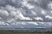
Rapid City features a steppe climate (Köppen BSk), and is part of USDA Hardiness zone 5a.[17] Its location makes its climate unlike both the higher elevations of the Black Hills and the Great Plains to the east. It is characterized by long arid summers and long dry winters, with short but distinct spring and autumn seasons. Precipitation averages 16.3 inches or 414.0 millimetres annually, but has historically ranged from 9.12 inches or 231.6 millimetres in 1974 to 27.70 inches or 703.6 millimetres in 1946.[18][19]
Winters are cold and dry, with December being the coldest month in recent years, with a daily average temperature of 24.9 °F or −3.9 °C. Chinook winds can warm temperatures above 50 °F or 10 °C, doing so on average about 21 times from December to February. Temperature inversions, however, occasionally produce warmer temperatures in the Black Hills. On average, highs do not climb above freezing on 42 days, while the low temperature reaches 0 °F or −17.8 °C on an average of seventeen nights.[18] Snowfall is frequent but usually not heavy; March and April are typically the snowiest months. The seasonal total averages 41 inches or 1.04 metres, although historically ranging from 16.9 inches or 0.43 metres during 1980–81 to 80.9 inches or 2.05 metres during 1985–86. Extensive snow cover does not remain for long, with only nine days seasonally with 5 inches or 0.13 metres or more on the ground.[19] Measurable snow has occurred in every month except July.[18]
Compared to locations in the east, the area warms rather gradually early in the year, with the last measurable snow typically occurring in late April and precipitation totals beginning to increase; May snow occurs several times per decade. Toward the middle of the year, storms typically develop over the Black Hills during the afternoon and move onto the plains in the evening. Only in April through June have calendar-day precipitation amounts exceeding 3 inches or 76.2 millimetres been observed. June 15, 1963, with 3.78 inches or 96.0 millimetres, holds the single-day rainfall record;[18] the record-wettest month is May 1996 with 8.18 inches or 207.8 millimetres.[18] Rapid City has an average of twenty clear to partly cloudy days[20] and 67 percent of its possible sunshine in June.[21] This is the traditional "flood" season for Rapid and other creeks in the Eastern Hills. Temperatures warm rapidly as summer approaches.
Summer in Rapid City has relatively pleasant temperatures, and is relatively dry, and relatively sunny. July is the warmest month of the year, having a daily average temperature of 72.6 °F (22.6 °C). An average of 34 days reach 90 °F (32.2 °C)+ highs and 5.1 with 100 °F (37.8 °C)+ highs.[19] Due to the elevation and aridity, lows rarely remain at or above 70 °F (21.1 °C) and during July and August fall to or below 50 °F or 10 °C on an average 7.6 days.[18] Rapid City records an average of nine thunderstorm days in August,[20] but only 1.56 inches or 39.6 millimetres of rain in that month.
Fall is a transition season: the average first freeze occurs in Rapid City on October 4 and in the Black Hills in late August through September. The Rapid City area's first snowfall is usually in October, although higher elevations sometimes receive significant snow in September. Occasional cold fronts moving through the area bring blustery northwest winds.
Sunshine is abundant in the region in all months except December, averaging 2850 hours, 64% of the possible total, per year.[21]
Rapid City holds a record for an extreme temperature drop of 47 °F or 26.1 °C in five minutes on January 10, 1911, from 60 °F or 16 °C to 13 °F or −11 °C.[22] Official extreme temperatures range from −31 °F or −35 °C on February 2, 1996 up to 111 °F or 44 °C on July 15, 2006; the record low daily maximum is −18 °F or −28 °C on February 2, 1989, while the record high daily minimum is 75 °F or 24 °C on July 8, 1985 and July 28, 1960.[23]
| Climate data for Rapid City Regional Airport, South Dakota (1981−2010 normals,[lower-alpha 1] extremes 1942−present)[lower-alpha 2] | |||||||||||||
|---|---|---|---|---|---|---|---|---|---|---|---|---|---|
| Month | Jan | Feb | Mar | Apr | May | Jun | Jul | Aug | Sep | Oct | Nov | Dec | Year |
| Record high °F (°C) | 76 (24) |
75 (24) |
83 (28) |
93 (34) |
98 (37) |
109 (43) |
111 (44) |
107 (42) |
104 (40) |
96 (36) |
83 (28) |
75 (24) |
111 (44) |
| Mean maximum °F (°C) | 62.3 (16.8) |
64.4 (18.0) |
74.2 (23.4) |
82.3 (27.9) |
88.1 (31.2) |
94.7 (34.8) |
101.9 (38.8) |
100.4 (38.0) |
95.5 (35.3) |
85.6 (29.8) |
72.2 (22.3) |
61.2 (16.2) |
103.5 (39.7) |
| Average high °F (°C) | 37.1 (2.8) |
39.6 (4.2) |
47.9 (8.8) |
58.3 (14.6) |
67.8 (19.9) |
77.8 (25.4) |
87.1 (30.6) |
86.4 (30.2) |
75.6 (24.2) |
61.4 (16.3) |
47.0 (8.3) |
36.9 (2.7) |
60.4 (15.8) |
| Average low °F (°C) | 12.9 (−10.6) |
15.1 (−9.4) |
22.9 (−5.1) |
31.8 (−0.1) |
42.1 (5.6) |
51.2 (10.7) |
58.1 (14.5) |
56.6 (13.7) |
46.0 (7.8) |
34.1 (1.2) |
22.1 (−5.5) |
13.0 (−10.6) |
33.9 (1.1) |
| Mean minimum °F (°C) | −8.4 (−22.4) |
−7.1 (−21.7) |
3.4 (−15.9) |
16.5 (−8.6) |
27.7 (−2.4) |
39.5 (4.2) |
47.9 (8.8) |
46.1 (7.8) |
30.4 (−0.9) |
16.7 (−8.5) |
2.7 (−16.3) |
−9.7 (−23.2) |
−18.5 (−28.1) |
| Record low °F (°C) | −27 (−33) |
−31 (−35) |
−21 (−29) |
1 (−17) |
18 (−8) |
31 (−1) |
39 (4) |
38 (3) |
18 (−8) |
−2 (−19) |
−19 (−28) |
−30 (−34) |
−31 (−35) |
| Average precipitation inches (mm) | 0.30 (7.6) |
0.44 (11) |
0.93 (24) |
1.80 (46) |
3.22 (82) |
2.53 (64) |
1.85 (47) |
1.56 (40) |
1.29 (33) |
1.42 (36) |
0.53 (13) |
0.42 (11) |
16.29 (414) |
| Average snowfall inches (cm) | 4.4 (11) |
5.8 (15) |
8.7 (22) |
7.9 (20) |
1.1 (2.8) |
0 (0) |
0 (0) |
0 (0) |
0.2 (0.51) |
1.6 (4.1) |
6.0 (15) |
5.4 (14) |
41.1 (104) |
| Average precipitation days (≥ 0.01 in) | 5.4 | 5.7 | 7.6 | 9.5 | 11.7 | 12.3 | 9.5 | 7.7 | 7.0 | 7.2 | 5.3 | 5.4 | 94.3 |
| Average snowy days (≥ 0.1 in) | 5.4 | 5.8 | 5.3 | 4.4 | 0.4 | 0 | 0 | 0 | 0.4 | 1.5 | 4.1 | 5.8 | 33.1 |
| Average relative humidity (%) | 63.5 | 65.1 | 63.8 | 58.6 | 60.8 | 61.9 | 56.2 | 52.6 | 53.5 | 54.2 | 62.2 | 64.8 | 59.8 |
| Mean monthly sunshine hours | 163.5 | 174.0 | 233.9 | 246.9 | 274.3 | 310.5 | 335.5 | 323.8 | 261.9 | 226.0 | 156.6 | 149.9 | 2,856.8 |
| Percent possible sunshine | 57 | 59 | 63 | 61 | 60 | 67 | 72 | 75 | 70 | 66 | 54 | 54 | 64 |
| Source: NOAA (relative humidity and sun 1961−1990)[18][23][21] | |||||||||||||
Demographics
| Historical population | |||
|---|---|---|---|
| Census | Pop. | %± | |
| 1880 | 939 | — | |
| 1890 | 2,128 | 126.6% | |
| 1900 | 1,342 | −36.9% | |
| 1910 | 3,454 | 157.4% | |
| 1920 | 5,777 | 67.3% | |
| 1930 | 10,464 | 81.1% | |
| 1940 | 13,844 | 32.3% | |
| 1950 | 25,312 | 82.8% | |
| 1960 | 42,390 | 67.5% | |
| 1970 | 43,846 | 3.4% | |
| 1980 | 46,492 | 6.0% | |
| 1990 | 54,523 | 17.3% | |
| 2000 | 59,607 | 9.3% | |
| 2010 | 67,956 | 14.0% | |
| Est. 2018 | 75,443 | [5] | 11.0% |
| U.S. Decennial Census[24] 2018 Estimate[25] | |||
2010 census
As of the census[4] of 2010, there were 67,956 people, 28,586 households, and 16,957 families residing in the city. The population density was 1,226.4 inhabitants per square mile (473.5/km2). There were 30,254 housing units at an average density of 546.0 per square mile (210.8/km2). The racial makeup of the city was 80.4% White, 1.1% African American, 12.4% Native American, 1.0% Asian, 0.1% Pacific Islander, 0.7% from other races, and 4.1% from two or more races. Hispanic or Latino of any race were 4.1% of the population.
There were 28,586 households of which 29.9% had children under the age of 18 living with them, 41.2% were married couples living together, 13.1% had a female householder with no husband present, 5.1% had a male householder with no wife present, and 40.7% were non-families. 32.9% of all households were made up of individuals and 11.1% had someone living alone who was 65 years of age or older. The average household size was 2.29 and the average family size was 2.90.
The median age in the city was 35.6 years. 23.9% of residents were under the age of 18; 10.6% were between the ages of 18 and 24; 25.7% were from 25 to 44; 25% were from 45 to 64; and 14.5% were 65 years of age or older. The gender makeup of the city was 49.5% male and 50.5% female.[26]
2000 census
As of the census of 2000, there were 59,607 people, 23,969 households, and 15,220 families residing in the city. The population density was 1,336.7 people per square mile (516.1/km2). There were 25,096 housing units at an average density of 562.8 per square mile (217.3/km2).[16] The racial makeup of the city was 84.33% White, 0.97% African American, 10.14% Native American, 1.0% Asian, 0.06% Pacific Islander, 0.73% from other races, and 2.77% from two or more races.[27] Hispanic or Latino of any race were 2.77% of the population.[27]
There were 23,969 households out of which 31.2% had children under the age of 18 living with them, 46.7% were married couples living together, 12.6% had a female householder with no husband present, and 36.5% were non-families. 29.4% of all households were made up of individuals and 10.0% had someone living alone who was 65 years of age or older. The average household size was 2.39 and the average family size was 2.96.[27]
In the city, the population was spread out with 25.3% under the age of 18, 11.8% from 18 to 24, 28.7% from 25 to 44, 20.9% from 45 to 64, and 13.2% who were 65 years of age or older. The median age was 35 years. For every 100 females, there were 96.2 males. For every 100 females age 18 and over, there were 93.6 males.[26]
As of 2000 the median income for a household in the city was $35,978, and the median income for a family was $44,818. Males had a median income of $30,985 versus $21,913 for females. The per capita income for the city was $19,445. About 9.4% of families and 12.7% of the population were below the poverty line, including 17.6% of those under age 18 and 6.9% of those age 65 or over.
Healthcare
Rapid City is a major healthcare center for a five-state region, centered around Monument Health Rapid City Hospital, which operates under the not-for-profit parent company Monument Health, a member of The Mayo Clinic Care Network, Monument Health continues to operate independently and is governed by a volunteer board of directors. Monument Health Rapid City Hospital has the busiest Emergency Department in South Dakota with 57,000 visits annually, they are a certified level 2 Trauma Center. Monument Health offers care in 33 medical specialties and serves 20 communities across western South Dakota and in eastern Wyoming. With over 4,500 physicians and caregivers, Monument Health consists of 5 hospitals, 8 specialty and surgical centers and more than 40 medical clinics and health care service centers. In 2017 Monument Health Rapid City Hospital received recognition as one of "America's Best 250 Hospitals for Clinical Excellence" by Healthgrades, only 258 hospitals in the United States received the prestigious award, which equals out to be just 5% of hospitals in the entire country.
There are several Urgent Care facilities in Rapid City, mainly operated by Monument Health and private for-profit groups. Monument Health has the only nationally accredited Urgent Care centers in the entire state of South Dakota.
Other independent, for-profit medical facilities have been established in the area, centered around Black Hills Surgical Hospital, which is owned by Medical Facilities Corporation a for-profit Canadian based company, they trade on the Toronto Stock Exchange under the symbol DR. Black Hills Neurosurgery and spine, Black Hills Orthopedics, Ballard Gynecology, ProMotion Physical Therapy, Rapid City Medical Center, Rushmore OB/GYN, The Rehab Doctors and West River ENT are all either owner by, operated or affiliated with Black Hills Surgical Hospital and for-profit parent company MFC. Other private for-profit groups exist such as Black Hills Pediatrics, Black Hills Eye Institute, as well as local, smaller providers.
Specialized government health facilities include the Indian Health Service’s Oyate Health Center (formerly Sioux San Hospital), which provides care to the Native American community, and Veterans Affairs hospitals located nearby at Fort Meade and Hot Springs, South Dakota. The VA also has a small, outpatient clinic in Rapid City.
Emergency medical services (EMS) are provided by the Rapid City Fire Department. Emergency medical transportation by rotor and fixed wing aircraft is provided by Black Hills Life Flight, operated by Air Methods Corp. based in Denver, Colorado, and MARC (Medical Air Rescue Company), owned by Dale Aviation and based in Rapid City. Apollo Air Methods also operates Medical Helicopters in the Black Hills area.
This is also the location of a number of non-profit public health organizations that engage in survey and clinic research, epidemiology, and area-based health promotion disease prevention. The Health Education and Promotion Council and Black Hills Center for American Indian Health are two notable non-profit organizations.
Education
The Rapid City Public Library is a major resource for education.[28]
Rapid City institutions of higher education include the South Dakota School of Mines and Technology, Oglala Lakota College's He Sapa College Center, Black Hills State University - Rapid City University Center (includes classes and degrees through five other South Dakota post-secondary Institutions), National American University, Western Dakota Technical Institute, Black Hills Beauty College, John Witherspoon College, and several small sectarian preacher training schools.
Black Hills State University is located in nearby Spearfish and offers several classes in Rapid City. The South Dakota state nurse training program is based in Rapid City.
In 2013, 26.6 percent of Rapid City residents 25 years or over had earned a bachelor's degree or higher.[29] This is on par with the average educational attainment in the United States. The highest rates of educational attainment in South Dakota can be found in metropolitan areas of Rapid City and Sioux Falls.
The local public schools fall under the Rapid City Area Schools school district. There are three high schools within the district: Central, Stevens and the newly renovated Rapid City High School, which also houses the Performing Arts Center. The middle schools include East, North, South, Southwest, and West. There are 16 elementary schools within the district. These are Black Hawk, Canyon Lake, Corral Drive, General Beadle, Grandview, Horace Mann, Kibben Kuster, Knollwood Heights, Meadowbrook, Pinedale, Rapid Valley, Robbinsdale, South Canyon, South Park, Valley View, and Woodrow Wilson.[30]
There are also various private schools in Rapid City. The city has four Christian high schools including Saint Thomas More, Rapid City Christian High School, Liberty Baptist Academy, and Open Bible Christian School. Rapid City also has various private grade schools mincluding St. Paul's Lutheran School of the WELS.[31]
Sports
- The Black Hills Posse was a professional basketball club that competed in the International Basketball Association beginning in the 1995–96 season.
- The Black Hills Gold was a professional basketball club that competed in the International Basketball Association during the 1999–2000 season.
- The Rapid City Flying Aces were an indoor football team that competed between 2000 and 2006 in the Indoor Football League, United Indoor Football, and National Indoor Football League, changing names from season to season.
- The Rapid City Rush is a minor league hockey team in the ECHL.
- The Rapid City Thrillers were a professional basketball club that competed in the Continental Basketball Association beginning in the 1987–88 season through the 1996–97 season.
Art and culture
Because of the importance of tourism in the area, and its extensive market area, Rapid City has many cultural resources usually found only in much larger urban areas. Among these are:
- The Journey Museum
- Museum of Geology[32]
- Dahl Arts Center[33]
- Suzie Cappa Art Center[34]
- Rushmore Plaza Civic Center
- Black Hills Playhouse[35]
- Storybook Island Theater
- Art Alley Gallery[36]
- The Performing Arts Center of Rapid City[37]
- Black Hills Community Theatre[38]
- Black Hills Symphony Orchestra
- Black Hills Chamber Orchestra
- Prairie Edge Art Gallery[39]
- Chapel in the Hills
- Main Street Square[40]

Rapid City has invested in public sculptures, which are on display in many parts of the city. The most visible is "The City of Presidents", a series of life-sized bronze statues representing each former President of the United States. The statues are located on street corners in the downtown area. Five South Dakota artists created the statues: Edward E. Hlavka, Lee Leuning, John Lopez, James Michael Maher, and James Van Nuys.[41] The first 42 statues were erected via private donations over a ten-year period between 2000 and 2010. As of 2019, Barack Obama is the most recent president to have a statue erected; currently sitting presidents are ineligible.
Sister cities
Rapid City has three sister cities, as designated by Sister Cities International:


Rapid City Nikko City Sister City Association

Industry and economy
Rapid City's economy is diverse, but industry is a small portion, as is typical of many US cities in the 21st century. Heavy and medium industrial activities include a Portland cement plant (constructed and owned for 84 years[42] by the State of South Dakota and sold in 2003 to GCC, a Mexican-based conglomerate); Black Hills Ammunition, an ammunition and reloading supplies manufacturing company; several custom sawmills, a lime plant, a computer peripheral component manufacturing plant, and several farm and ranch equipment manufacturers. Of particular note, this city is the center for the manufacture of Black Hills gold jewelry, a popular product with tourists and Westerners in general. The city is the site of the only American manufacturer of stamping machines used for the labeling of plywood and chipboard products.
Most gold mining has ceased in the Black Hills and was never conducted in or near Rapid City. Regional mining operations include for sand and gravel, as well as the raw materials for lime and Portland cement (including chemical-grade limestone, taconite iron ore, and gypsum) remains an important part of the economy.
The largest sector of the Rapid City economy is government services, including local, state, and federal. Major employers include Ellsworth Air Force Base,[43] home of the 28th Bomb Wing flying the B-1B long-range bomber; the Army National Guard based at Camp Rapid and hosting annual exercises in the Black Hills, drawing troops from five to ten states; and various federal agencies, including the National Park Service, US Forest Service, and Indian Health Service.
Regional Health covers one of the largest geographic service areas in the United States. The health care sector employs more than 8,000 persons in the Rapid City area.[43]
Tourism constitutes a major portion of the Rapid City economy,[43] due to the proximity of Mount Rushmore, Sturgis, home of the Sturgis Motorcycle Rally; Deadwood, and other attractions in the Black Hills. This city provides most services for the Motorcycle Rally. Prepared to satisfy the Rally's demand for motel rooms, camp sites, and other services for tourists during the first week of August, Rapid City has the capacity to host other large events, such as conventions, and numerous associated tourists year-round. Various minor tourist attractions, including wildlife parks, specialty shops, caves, water parks, private museums, and other businesses are found in and near Rapid City.
Other economic sectors include financial service and investing companies such as Waddell and Reed, Citibank, WaMu, Merrill Lynch, and Northwestern Mutual. Rapid City is the headquarters for Assurant Insurance's pre-need division. As noted, the city has a strong medical services sector, and several institutions of higher education. Rapid City is also the major market town for much of five states, drawing commerce from more than half of South Dakota, and large portions of North Dakota, Montana, Wyoming, and the Nebraska Panhandle.
The real compound annual growth rate of the gross domestic product of the Rapid City Metropolitan Statistical Area was 2.6% for 2001–2013.[44]
Transportation
Air
Rapid City is a major transportation hub for the Northern Plains. Rapid City Regional Airport provides flights to the airline hub cities of Denver, Minneapolis, Salt Lake City, Dallas-Fort Worth, Las Vegas, Phoenix/Mesa, Houston, Atlanta and Chicago. The airport also has extensive General Aviation operations, including wildfire fighting activities, and medical flight support to Rapid City medical facilities and regional Indian Health Service operations.
Railroad
Historically, Rapid City was served by three railroads. Following extensive restructuring in the industry in the late 20th and early 21st centuries, the city is now served only by the Rapid City, Pierre and Eastern Railroad (RCP&E). In addition to Rapid City, the RCP&E serves the Northern Black Hills and run east to Minnesota and south through Nebraska to connect with major transcontinental railroads Burlington Northern Santa Fe and Union Pacific. Until the 1950s Chicago and Northwestern Railroad ran a daily passenger train from Chicago to Rapid City. Neither South Dakota nor Wyoming have any Amtrak service.
Road
Rapid City's central location on the continent enables it to transport products to both coasts, and points in between. Trucking is a major business activity in the city. Improved connections with Denver and I-80 to the south, via the Heartland Expressway now under construction, will primarily benefit local trucking.
Infrastructure
- Interstate 90 is the primary east–west route for Rapid City. The city is served by a series of 7 exits. I-90 skims the northern side of the city. The South Dakota DOT has been reconstructing most of these interchanges in the last five years.
- Interstate 190 is an Interstate spur linking downtown Rapid City to Interstate 90.
- US Highway 16 is the main route to the southwest and the Black Hills from Rapid City. It links Rapid City to Custer and then west to Newcastle, Wyoming, where it connects to US Highway 85 for travel to Cheyenne and Denver. Reconstructed in the mid-1960s as a four-lane parkway connecting Rapid City to Mount Rushmore, since 2008 major segments have been rebuilt as three-lane, or "super-two" highways, to support increased tourist traffic.
- South Dakota Highway 44 is a state highway that links the interior of the Black Hills to the southwest of Rapid City, and the Pine Ridge Indian Reservation and nearby areas in the Great Plains to the southeast.
- South Dakota Highway 79 is a state highway that is multiplexed with I-90 northwest of Rapid City. SD Highway 79 extends to North Dakota. South of Rapid City to Nebraska, Highway 79 is being reconstructed as the Heartland Expressway, a high-speed, four-lane highway that will eventually connect to Interstate 80 in Nebraska and the Colorado Front Range near Denver. The Heartland Expressway may eventually be extended along US Highway 85 north to Regina, Saskatchewan, to create an additional major north–south artery through the Great Plains that would pass through Rapid City.
Rapid City is located on the boundary of the Western and Eastern power grids. It is served by the hydroelectric plants of the two Mainstem dams on the Missouri River, and the large coal fields and power plants of the Powder River Basin of Wyoming. It is located where the two national power grids connect with each other, allowing switching of electrical power from east to west and vice versa. Rapid City had its own coal-fired power plant but could not afford to meet current air pollution standards and closed it. Closed for similar reasons were coal-fired power stations near Gillette, Wyoming. The Ben French power station located within city boundaries shut down September 2012, more than 2 years ahead of its scheduled shut down. Rapid City now obtains much of its power from the Missouri dams and importing it from elsewhere. Following the shut down of the plants dependent on cheap, polluting coal, electrical rates have risen. The city has had to spend more to import electricity over a longer distance.

Rapid City obtains most of its water supply from Rapid Creek and the alluvial aquifers associated with the creek, owning significant water rights in Pactola Reservoir located some 15 miles (24 km) west of the city, but does also obtain water from some springs in the vicinity, and has the ability to draw water from deep formations that receive water from recharge in areas of the Black Hills where the formations come to the surface. The heavy dependence on shallow alluvial aquifers is of some concern to planners, as most suburbs of Rapid City use septic systems for domestic sewage treatment. However, water supplies remain relatively good for future growth.
Rapid City has a municipally owned bus service, providing multiple bus stops and a headquarters in the city. It has limited city-to-city bus service along I-90. Charter bus services operate in the area, connecting Rapid City and Deadwood with cities in Colorado, Nebraska, and Iowa.
Suburbs
The estimated 2013 population of the Rapid City Metropolitan Statistical Area (Pennington County, Meade County and Custer County) was 141,131.[45] A significant portion of residents from cities and towns in the Black Hills and nearby plains commute to Rapid City for work. Increasingly, some residents of the city commute to outlying areas for work as well.
Among the nearer suburbs in Pennington and Meade counties:
- Ashland Heights
- Rapid Valley
- Blackhawk
- Piedmont Valley
- Piedmont
- Box Elder
- Colonial Pine Hills
- Caputa
- Hermosa
- Nemo
- Rimrock Area
- Johnson Siding
- Rockerville
- Summerset
- Whispering Pines
- Moon Meadows
Local media
AM radio
| AM radio stations | ||||||
|---|---|---|---|---|---|---|
| Frequency | Call sign | Name | Format | Owner | City of License | Broadcast Market |
| 580 AM | KZMX | 580 Country | Country | Mt. Rushmore Broadcasting, Inc. | Hot Springs | Rapid City |
| 810 AM | KBHB | Five State Ranch Radio | Farm | HomeSlice Media Group, LLC | Sturgis | Rapid City |
| 920 AM | KKLS | The Cowboy | Classic Country | HomeSlice Media Group, LLC | Rapid City | Rapid City |
| 980 AM | KDSJ | Oldies | Goldrush Broadcasting, Inc. | Deadwood | Rapid City | |
| 1150 AM | KIMM | Fox Sports Rapid City | Sports | Gunslinger Radio, Inc. | Rapid City | Rapid City |
| 1340 AM | KTOQ | ESPN Rapid City | Sports | Haugo Broadcasting, Inc. | Rapid City | Rapid City |
| 1380 AM | KOTA | News Radio KOTA | News/Talk | Riverfront Broadcasting | Rapid City | Rapid City |
FM radio
| FM radio stations | ||||||
|---|---|---|---|---|---|---|
| Frequency | Call sign | Name | Format | Owner | Target city/market | City of license |
| 88.3 FM | KLMP | The Light | Christian | Bethesda Christian Broadcasting | Rapid City | Rapid City |
| 88.7 FM | K204FB | KILI-FM | Community Radio KILI-FM translator | Lakota Communications Inc. | Rapid City | Rapid City |
| 89.3 FM | KBHE | South Dakota Public Broadcasting | NPR | SD Board of Directors for Educational Telecommunications | Rapid City | Rapid City |
| 89.9 FM | KJRC | Real Presence Radio | Catholic Radio | Real Presence Radio | Rapid City | Rapid City |
| 90.3 FM | KASD | Bott Radio Network | Christian | Bott Radio Network | Rapid City | Rapid City |
| 91.3 FM | KTEQ-FM | K-Tech | Alternative | South Dakota School of Mines and Technology Educational Radio Council | Rapid City | Rapid City |
| 91.7 FM | K218DX | CSN International | Christian KAWZ-FM translator | CSN International | Rapid City | Box Elder |
| 92.3 FM | KQRQ-FM | Q92.3 | Classic Hits | Riverfront Broadcasting | Rapid City | Rapid City |
| 93.1 FM | KRCS | Hot 93.1 | Top 40 | HomeSlice Media Group, LLC | Rapid City | Sturgis |
| 93.9 FM | KKMK | 93.9 The Mix | Hot AC | HomeSlice Media Group, LLC | Rapid City | Rapid City |
| 94.7 FM | K234BR | Real Presence Radio | Catholic Radio KJRC Translator | Real Presence Radio | Rapid City | Rapid City |
| 95.1 FM | KSQY | K-Sky | Album-Oriented Rock | Haugo Broadcasting, Inc. | Rapid City | Deadwood |
| 95.9 FM | KZZI | The Eagle | Country | Riverfront Broadcasting | Rapid City | Belle Fourche |
| 96.3 FM | K242BK | The Eagle | Country KZZI Translator | Riverfront Broadcasting | Rapid City | Rapid City |
| 97.1 FM | KFND-LP | Religious | Calvary Chapel of the Black Hills | Rapid City | Rapid City | |
| 97.5 FM | K248BT | Hot 93.1 | Top 40 KRCS Translator | HomeSlice Media Group, LLC | Rapid City | Rapid City |
| 97.9 FM | KTPT | The Breeze | Christian Contemporary | Bethesda Christian Broadcasting | Rapid City | Rapid City |
| 98.7 FM | KOUT | Kat Country 98.7 | Country | HomeSlice Media Group, LLC | Rapid City | Rapid City |
| 99.5 FM | KRKI-FM1 | 99-5/107-9 True Country | Classic Country KRKI-FM booster | Bad Lands Broadcasting | Rapid City | Rapid City |
| 100.3 FM | KFXS | 100.3 The Fox | Classic Rock | HomeSlice Media Group, LLC | Rapid City | Rapid City |
| 100.7 FM | K264CP | News Radio KOTA | News/Talk KOTA-AM Translator | Riverfront Broadcasting | Rapid City | Rapid City |
| 101.1 FM | KDDX | X-Rock | Active Rock | Riverfront Broadcasting | Rapid City | Spearfish |
| 101.9 FM | KFMH-FM1 | Kool 101.9 | Oldies KFMH-FM booster | Bad Lands Broadcasting | Rapid City | Rapid City |
| 102.7 FM | KXMZ | Hits 102.7 | Hot AC | Haugo Broadcasting, Inc. | Rapid City | Box Elder |
| 103.5 FM | K278AN | X-Rock | Active Rock KDDX-FM translator | Riverfront Broadcasting | Rapid City | Rapid City |
| 104.1 FM | KIQK | Kick 104 | Country | Haugo Broadcasting, Inc. | Rapid City | Rapid City |
| 104.7 FM | K284BA | The Cowboy | Classic Country KKLS-AM Translator |
HomeSlice Media Group, LLC | Rapid City | Rapid City |
| 105.7 FM | K289AI | ESPN Rapid City | Sports | Haugo Broadcasting, Inc. | Rapid City | Rapid City |
| 106.3 FM | KZLK | Star 106.3 | Hot AC | Riverfront Broadcasting | Rapid City | Rapid City |
| 106.7 FM | K294BT | Fox Sports Rapid City | Sports KIMM-AM Translator | Black Hills Broadcasting, L.L.C. | Rapid City | Rapid City |
| 107.1 FM | KSLT | Power 107.1 | Christian Contemporary | Bethesda Christian Broadcasting | Rapid City | Spearfish |
| 107.9 FM | KXZT | 99-5/107-9 True Country | Country | Bad Lands Broadcasting | Rapid City | Newell |
Television
Print
- Black Hills Visitor Magazine (since 1984)[46]
- Black Hills Bride
- Black Hills Parent
- Rapid City Journal
- Patriot (Ellsworth AFB Bulletin)
Places of interest
- Dinosaur Park
- Hart Ranch
- Reptile Gardens
- Bear Country USA
- Storybook Island
- Watiki Waterpark
- Berlin Wall in Memorial Park
- South Dakota School of Mines and Technology
- The Journey Museum and Gardens
- Rapid City Public Library
- Rushmore Mall
- Main Street Square[40]
Notable people
People who have lived, resided, or were born in Rapid City, South Dakota.
- Notable Rapid City people include:

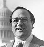 James Abourezk
U.S. Senator & U.S. Representative from South Dakota, First Arab-American member of Congress
and
Author, Indian Child Welfare Act..jpg) Adam Vinatieri,
Adam Vinatieri,
NFL Kicker and 4x Super Bowl Champion
- Catherine Bach – Actress, best known as Daisy Duke in The Dukes of Hazzard
- Shane Van Boening – Professional billiards player
- Dave Collins – Professional baseball player
- Jessi Combs – Professional car racer and television figure[47]
- Sean Doolittle – Professional baseball player
- Mark Ellis – Professional baseball player
- Meryle Fitzgerald – All-American Girls Professional Baseball League ballplayer
- Jack van der Geest – Holocaust survivor and postwar resident, author of Was God on Vacation?
- Emily Graslie – Correspondent for Chicago Field Museum and YouTube program host
- Dick Green – Professional baseball player
- Bill Groethe – Photographer who took picture of last eight survivors of 1876's Battle of the Little Bighorn
- David Hallberg – Principal dancer with American Ballet Theatre and the Bolshoi Ballet
- Becky Hammon – San Antonio Spurs coach
- John Sherrill Houser – Painter and sculptor
- Carrie Ingalls – Younger sister of author Laura Ingalls Wilder
- Tomi Lahren - Political commentator
- Lawrence Lessig – Harvard Law School professor, co-founder of the Creative Commons
- Randy Lewis - 1980 and 1984 Olympian wrestler and 1984 Olympic freestyle champion at 136.5 lbs
- Hunter Nope- Professional wrestler "Hunter Kent" in Japan & Lucha Libre (Puerto Rico & Mexico)
- Eric Piatkowski – NBA player and former Nebraska Cornhusker
- Neal Tapio – 2016 Trump presidential campaign director
- Kelvin Torve– Major League Baseball player for the Minnesota Twins and New York Mets
- Adam Vinatieri – NFL kicker for the Indianapolis Colts
- Chauncey Yellow Robe ("Kills in the Woods") (Canowicakte) (1867–1930) – Lakota educator, lecturer and activist
- Rosebud Yellow Robe – Native American folklorist, educator and author
- Anthony Allen Shore - serial killer, convicted and executed in Texas
Notes
- Mean monthly maxima and minima (i.e. the expected highest and lowest temperature readings at any point during the year or given month) calculated based on data at said location from 1981 to 2010.
- Official temperature and precipitation records for Rapid City kept at the old municipal airport from August 1942 to October 11, 1950, and at Rapid City Regional since October 12, 1950.[23] Snowfall and snow depth records date to September 1, 1942 and the move to Rapid City Regional, respectively.[18]
References
- Hasselstrom, p. 331.
- "Fred E. Stearns". Rapid City Library. Archived from the original on January 24, 2016. Retrieved October 25, 2015.
- "2018 U.S. Gazetteer Files". United States Census Bureau. Retrieved February 22, 2020.
- "U.S. Census website". United States Census Bureau. Retrieved June 21, 2012.
- "Population and Housing Unit Estimates". United States Census Bureau. June 27, 2019. Retrieved June 4, 2019.
- "US Board on Geographic Names". United States Geological Survey. October 25, 2007. Retrieved January 31, 2008.
- Ullrich, Jan F. (2014). New Lakota Dictionary (2nd ed.). Bloomington, IN: Lakota Language Consortium. ISBN 978-0-9761082-9-0. Archived from the original on 2016-10-18. Retrieved 2014-02-12.
- "Find a County". National Association of Counties. Retrieved June 7, 2011.
- "2010 Census Redistricting Data (Public Law 94-171) Summary File". American FactFinder. United States Census Bureau. Retrieved March 26, 2012.
- Jackson, William (2008). Almanac of North Dakota Mysteries & Oddities, 2009-2010. Valley Star Books. p. 44. ISBN 9780967734989. OCLC 259419005.
- "Retiring a Minuteman ICBM (LGM-30F)". U.S. Nuclear Weapons Cost Study Project. The Brookings Institution. Archived from the original on May 10, 2007. Retrieved October 4, 2007.
- Giago, Tim (2007-06-03). "The Black Hills: A Case of Dishonest Dealings". The Huffington Post. Retrieved 2007-10-26.
- "The 1972 Black Hills-Rapid City Flood Revisited". United States Geological Survey. Archived from the original on 2007-10-09. Retrieved 2007-10-15.
- (Burr and Korkow, 1996)
- 1972 Flood digital archive Archived 2012-02-10 at the Wayback Machine
- U.S. Census Bureau. Census 2000, Summary File 1. "GCT-PH1. Population, Housing Units, Area, and Density: 2000 - County -- Subdivision and Place". American FactFinder. <http://factfinder2.census.gov>. Retrieved 2008-01-31.
- "USDA Plant Hardiness Zone Map". United States Department of Agriculture Agricultural Research Service. Missing or empty
|url=(help) - "NowData - NOAA Online Weather Data". National Oceanic and Atmospheric Administration. Retrieved 2018-09-06.
- "Station Name: SD RAPID CITY RGNL AP". National Oceanic and Atmospheric Administration. Retrieved 2014-03-08.
- "Weatherbase: Historical Weather for Rapid City, South Dakota, United States of America". Retrieved September 5, 2009.
- "WMO Climate Normals for RAPID CITY/REGIONAL ARPT SD 1961–1990". National Oceanic and Atmospheric Administration. Retrieved March 10, 2014.
- Lyons, Walter A (1997). The Handy Weather Answer Book (2nd ed.). Detroit: Visible Ink press. ISBN 0-7876-1034-8.
- "Threaded Extremes". National Oceanic and Atmospheric Administration. Retrieved 2013-03-10.
- "U.S. Decennial Census". U.S. Census Bureau. Retrieved May 29, 2013.
- "Population Estimates". United States Census Bureau. Retrieved May 30, 2019.
- U.S. Census Bureau. Census 2000. "QT-P1. Age Groups and Sex, Rapid City". American FactFinder. <http://factfinder.census.gov>. Retrieved 2009-01-31.
- U.S. Census Bureau. Census 2000. "Census Demographic Profiles, Rapid City" (PDF). CenStats Databases. Retrieved 2009-01-31.
- "Rapid City Public Library Homepage". rcgov.org. Retrieved March 24, 2017.
- "Educational Attainment". South Dakota Dashboard. Retrieved November 14, 2014.
- "Rapid City Area Schools". Rapid City Area Schools. Archived from the original on December 22, 2007. Retrieved 2008-04-25.
- "St. Paul's Lutheran School & Preschool".
- "Museum of Geology Homepage". South Dakota School of Mines & Technology. Retrieved March 24, 2017.
- "Dahl Arts Center Homepage". Rapid City Arts Council. Retrieved March 24, 2017.
- "Suzie Cappa Art Center Homepage". Suzie Cappa Art Center - Studio & Gallery. Retrieved March 24, 2017.
- "Black Hills Playhouse Homepage". blackhillsplayhouse.com. Retrieved March 24, 2017.
- "Art Alley Homepage". artalley.awardspace.com. Archived from the original on July 7, 2011. Retrieved March 24, 2017.
- "Performing Arts Center of Rapid City Homepage". performingartsrc.org. Retrieved March 24, 2017.
- "Black Hills Community Theater Homepage". bhct.org. Retrieved March 24, 2017.
- "Prairie Edge Trading Co & Galleries Homepage". prairieedge.com. Retrieved March 24, 2017.
- Orlowski, Aaron. "Main Street Square marks anniversary". Rapid City Journal. Retrieved January 15, 2017.
- visitrapidcity.com, Rapid City South Dakota Convention & Visitors Bureau, Rapid City, 2010. Retrieved on November 15, 2010.
- Created by SD Constitutional Amendment, 1919.
- "Rapid City: Economy". City-Data.com. Retrieved 2008-10-16.
- "Economic Output (GDP)". South Dakota Dashboard. Retrieved November 14, 2014.
- "Population trends". South Dakota Dashboard. Retrieved November 14, 2014.
- "Black Hills Visitor Homepage". Retrieved March 24, 2017.
- "Jet-Car Speed Racer Jessi Combs Dies Trying to Break Record". US News. Retrieved 28 August 2019.
Bibliography
- Hasselstrom, Linda M. (1994). Roadside History of South Dakota. Missoula, MT: Mountain Press Publishing Company. ISBN 0-87842-262-5.
External links
Municipalities and communities of Pennington County, South Dakota, United States | ||
|---|---|---|
| Cities |
|  |
| Towns |
| |
| CDPs |
| |
| Former CDP |
| |
| Unincorporated communities |
| |
| Ghost towns |
| |
| Footnotes | ‡This populated place also has portions in an adjacent county or counties | |
Pierre (capital) | ||
| Topics |
|  Seal of South Dakota |
| Society | ||
| Regions |
| |
| Larger cities pop. over 5,000 |
| |
| Smaller cities pop. 1,000 - 5,000 |
| |
| Largest CDPs pop. over 1,000 |
| |
| Largest towns pop. over 500 |
| |
| Counties |
| |
| Authority control |
|
|---|