Fargo, North Dakota
Fargo is a city in and the county seat of Cass County, North Dakota, United States. The most populous city in the state, it accounts for nearly 17% of the state population.[5] According to the 2018 United States Census estimates, its population was 124,844, making it the 222nd-most populous city in the United States.[6] Fargo, along with its twin city of Moorhead, Minnesota, as well as the adjacent cities of West Fargo, North Dakota and Dilworth, Minnesota, form the core of the Fargo-Moorhead, ND-MN Metropolitan Statistical Area, which in 2018 contained a population of 245,471.[7]
Fargo, North Dakota | |
|---|---|
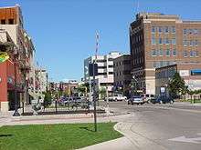
.jpg) Downtown as seen from Main Avenue, facing east | |
 Seal | |
| Motto(s): Gateway to the West | |
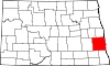
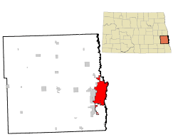 Location within Cass County | |
 Fargo Location within North Dakota  Fargo Location within the United States | |
| Coordinates: 46°52′38″N 96°47′22″W | |
| Country | |
| State | |
| County | Cass |
| Founded | 1871 |
| Government | |
| • Mayor | Tim Mahoney (D) |
| Area | |
| • City | 48.82 sq mi (126.44 km2) |
| • Land | 48.82 sq mi (126.44 km2) |
| • Water | 0 sq mi (0 km2) |
| Elevation | 904 ft (274 m) |
| Population | |
| • City | 105,549 |
| • Estimate (2018)[3] | 124,844 |
| • Rank | US: 222nd ND: 1st |
| • Density | 2,200/sq mi (830/km2) |
| • Urban | 176,676 (US: 194th) |
| • Metro | 245,471 (US: 189th) |
| • Demonym | Fargoan |
| Time zone | UTC-6 (CST) |
| • Summer (DST) | UTC-5 (CDT) |
| ZIP Codes | 58102-58109, 58121-58122, 58124-58126 |
| Area code | 701 |
| FIPS code | 38-25700 |
| GNIS feature ID | 1028945[4] |
| Highways | I-29, I-94, I-94 Bus., US 10, US 52, US 81, US 81 Bus., ND 294 |
| Website | www |
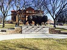
Founded in 1871 on the Red River of the North floodplain,[8] Fargo is a cultural, retail, health care, educational, and industrial center for eastern North Dakota and northwestern Minnesota. The city is also home to North Dakota State University.
History
Early history
Historically part of Sioux (Dakota) territory, the area that is present-day Fargo was an early stopping point for steamboats traversing the Red River during the 1870s and 1880s. The city was originally named "Centralia," but was later renamed "Fargo" after Northern Pacific Railway director and Wells Fargo Express Company founder William Fargo (1818–1881). The area started to flourish after the arrival of the Northern Pacific Railroad and the city became known as the "Gateway to the West."
During the 1880s, Fargo became the "divorce capital" of the Midwest because of lenient divorce laws.[9]
A major fire struck the city on June 7, 1893, destroying 31 blocks of downtown Fargo, but the city was immediately rebuilt with new buildings made of brick, new streets, and a water system. More than 246 new buildings were built within one year. There were several rumors concerning the cause of the fire.[10]
The North Dakota Agricultural College was founded in 1890 as North Dakota's land-grant university, becoming first accredited by the North Central Association in 1915. In 1960, NDAC became known as North Dakota State University.
20th century
Early in the century, the automobile industry flourished, and in 1905, Fargo became home to the Pence Automobile Company.[11]
On Labor Day in 1910, Theodore Roosevelt visited Fargo to lay the cornerstone of the college's new library.[12] To a crowd of 30,000, Roosevelt spoke about his first visit to Fargo 27 years earlier, and credited his experience homesteading in North Dakota for his eventual rise to the presidency.[12]
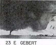
Fargo-Moorhead boomed after World War II, and the city grew rapidly despite a violent tornado in 1957 that destroyed a large part of the north end of the city. Ted Fujita, famous for his Fujita tornado scale, analyzed pictures of the Fargo tornado, which helped him develop his ideas for "wall cloud" and "tail cloud." These were the first major scientific descriptive terms associated with tornadoes.[13] The construction of two interstates (I-29 and I-94) revolutionized travel in the region and pushed growth of Fargo to the south and west of the city limits. In 1972, the West Acres Shopping Center, the largest shopping mall in North Dakota, was constructed near the intersection of the two Interstates. This mall became a catalyst for retail growth in the area.
Recent history
Fargo has continued to expand rapidly but steadily. Since the mid-1980s, the bulk of new residential growth has occurred in the south and southwest areas of the city due to geographic constraints on the north side. The city's major retail districts on the southwest side have likewise seen rapid development.
Downtown Fargo has been gentrified due in part to investments by the city and private developers in the Renaissance Zone. Most older neighborhoods, such as Horace Mann, have either avoided decline or been revitalized through housing rehabilitation promoted by planning agencies to strengthen the city's core.
NDSU has grown rapidly into a major research university, and forms a major component of the city's identity and economy. Most students live off-campus in the surrounding Roosevelt neighborhood. The university has established a presence downtown through both academic buildings and apartment housing. In addition, NDSU Bison Football has become a major sport following among many area residents.
Since the late 1990s, the Fargo-Moorhead Metropolitan Statistical Area has consistently had one of the lowest unemployment rates among MSAs in the United States. Coupled with Fargo's low crime rate and the decent supply of affordable housing in the community, this has prompted Money magazine to rank the city near the top of its annual list of America's most livable cities throughout the late 1990s and early 2000s.
Geography

Fargo is a core city of the Fargo-Moorhead metropolitan area, which also includes Moorhead, West Fargo, and Dilworth as well as outlying communities.
Fargo sits on the western bank of the Red River of the North in a flat geographic region known as the Red River Valley. The Red River Valley resulted from the withdrawal of glacial Lake Agassiz, which drained away about 9,300 years ago. The lake sediments deposited from Lake Agassiz made the land around Fargo some of the richest in the world for agricultural uses.
Fargo's largest challenge is the seasonal floods due to the rising water of the Red River, which flows from the United States into Lake Winnipeg in Manitoba, Canada. The Red flows northward, which means melting snow and river ice, as well as runoff from its tributaries, often create ice dams causing the river to overflow. Fargo's surrounding Red River Valley terrain is essentially flat, leading to overland flooding. Since the potentially devastating 2009 Red River flood, both Fargo and Moorhead have taken great strides in flood protection, only a near record flood would cause concern today.
Its location makes the city vulnerable to flooding during seasons with above average precipitation. The Red River's "minor" flood stage in Fargo begins at a level of 18 feet, with "major" flooding categorized at 30 feet and above. Many major downtown roadways and access to Moorhead are closed off at this level. Record snowfalls late in 1996 led to flooding in 1997, causing the Red to rise to a record crest of 39.5 feet, nearly overtaking city defenses. In 2008–2009, significant fall precipitation coupled with a rapid snowmelt in March 2009 caused the Red to rise to a new record level of 40.84 feet, but again Fargo remained safe, in large part due to flood mitigation efforts instituted after the 1997 event and sandbagging efforts by the city residents. Further upgrades were made to city infrastructure and additional resources brought to bear following the 2009 flood, which caused no issues for the city in 2010 despite another rapid melt that caused the Red to rise to 37 feet (which ranks among the top ten highest levels ever recorded). Recent discussions have focused on a $1.5 billion diversion project to channel the Red's water away from the city, but such a project is in the planning stages and being evaluated by various government agencies. As of 2012, Fargo has bought 700 houses in flood-prone areas.[14]
According to the United States Census Bureau, the city has an area of 48.82 square miles (126.44 km2), all land.[1]
Climate

Because of its location in the Great Plains and its distance from both mountains and oceans, Fargo has a humid continental climate (Köppen Dfa/Dfb), featuring long, exceedingly cold winters and warm to hot, humid summers. It lies in USDA Plant hardiness zone 4a.[15] The city features winters among the coldest in the contiguous United States; the coldest month of January has a normal mean temperature of 9.3 °F (−12.6 °C). There is an annual average of 43 days with a minimum of 0 °F (−18 °C) or lower.[16] Snowfall averages 50.1 inches (127 cm) per season.[16] Spring and autumn are short and highly variable seasons. Summers have frequent thunderstorms, and the warmest month, July, has a normal mean temperature of 71.0 °F (21.7 °C); highs reach 90 °F (32 °C) on an average of 12.7 days each year.[16] Annual precipitation of 22.6 inches (574 mm) is concentrated in the warmer months. Record temperatures have ranged from −48 °F (−44 °C) on January 8, 1887 to 114 °F (46 °C) on July 6, 1936; the record coldest daily maximum is −29 °F (−34 °C) on January 22, 1936, while, conversely, the record warmest daily minimum was 82 °F (28 °C), set four days after the all-time record high.[17] On average, the first and last dates to see a minimum at or below the freezing mark are September 30 and May 8, respectively, allowing a growing season of 144 days.[16]
In 2011, Fargo won The Weather Channel's "America's Toughest Weather City" poll. Almost 850,000 votes, blizzards, cold, and floods secured the title for the city.[18]
| Climate data for Fargo, North Dakota (Hector Int'l), 1981–2010 normals,[lower-alpha 1] extremes 1881–present[lower-alpha 2] | |||||||||||||
|---|---|---|---|---|---|---|---|---|---|---|---|---|---|
| Month | Jan | Feb | Mar | Apr | May | Jun | Jul | Aug | Sep | Oct | Nov | Dec | Year |
| Record high °F (°C) | 55 (13) |
66 (19) |
80 (27) |
100 (38) |
104 (40) |
104 (40) |
114 (46) |
106 (41) |
102 (39) |
97 (36) |
74 (23) |
65 (18) |
114 (46) |
| Mean maximum °F (°C) | 39.6 (4.2) |
43.1 (6.2) |
57.0 (13.9) |
79.9 (26.6) |
88.1 (31.2) |
91.6 (33.1) |
94.0 (34.4) |
93.8 (34.3) |
89.2 (31.8) |
78.2 (25.7) |
59.3 (15.2) |
41.2 (5.1) |
97.0 (36.1) |
| Average high °F (°C) | 18.4 (−7.6) |
23.7 (−4.6) |
36.3 (2.4) |
55.8 (13.2) |
69.3 (20.7) |
77.4 (25.2) |
82.5 (28.1) |
81.2 (27.3) |
70.8 (21.6) |
56.0 (13.3) |
37.3 (2.9) |
22.3 (−5.4) |
52.6 (11.4) |
| Daily mean °F (°C) | 9.3 (−12.6) |
14.6 (−9.7) |
27.8 (−2.3) |
44.2 (6.8) |
57.1 (13.9) |
66.2 (19.0) |
71.0 (21.7) |
69.3 (20.7) |
59.1 (15.1) |
45.5 (7.5) |
28.8 (−1.8) |
14.1 (−9.9) |
42.3 (5.7) |
| Average low °F (°C) | 0.1 (−17.7) |
5.6 (−14.7) |
19.4 (−7.0) |
32.7 (0.4) |
44.9 (7.2) |
55.0 (12.8) |
59.5 (15.3) |
57.3 (14.1) |
47.4 (8.6) |
35.1 (1.7) |
20.3 (−6.5) |
5.9 (−14.5) |
31.9 (0.0) |
| Mean minimum °F (°C) | −22.5 (−30.3) |
−19 (−28) |
−6.1 (−21.2) |
16.9 (−8.4) |
28.6 (−1.9) |
41.1 (5.1) |
47.1 (8.4) |
43.4 (6.3) |
30.7 (−0.7) |
19.3 (−7.1) |
0.3 (−17.6) |
−16.6 (−27.0) |
−26 (−32) |
| Record low °F (°C) | −48 (−44) |
−47 (−44) |
−34 (−37) |
−13 (−25) |
14 (−10) |
28 (−2) |
36 (2) |
32 (0) |
17 (−8) |
−4 (−20) |
−27 (−33) |
−36 (−38) |
−48 (−44) |
| Average precipitation inches (mm) | 0.70 (18) |
0.61 (15) |
1.30 (33) |
1.36 (35) |
2.81 (71) |
3.90 (99) |
2.79 (71) |
2.56 (65) |
2.57 (65) |
2.15 (55) |
1.00 (25) |
0.83 (21) |
22.58 (574) |
| Average snowfall inches (cm) | 11.2 (28) |
7.0 (18) |
9.1 (23) |
3.0 (7.6) |
trace | 0 (0) |
0 (0) |
0 (0) |
trace | 0.7 (1.8) |
7.9 (20) |
11.2 (28) |
50.1 (127) |
| Average precipitation days (≥ 0.01 in) | 8.3 | 7.2 | 8.3 | 7.4 | 11.0 | 11.7 | 9.5 | 9.1 | 8.7 | 8.3 | 7.1 | 9.2 | 105.8 |
| Average snowy days (≥ 0.1 in) | 8.9 | 6.7 | 5.3 | 1.8 | 0 | 0 | 0 | 0 | 0 | 0.8 | 5.4 | 9.5 | 38.4 |
| Average relative humidity (%) | 73.1 | 74.7 | 76.0 | 65.6 | 60.0 | 66.1 | 66.9 | 66.5 | 69.2 | 68.8 | 75.7 | 76.1 | 69.9 |
| Mean monthly sunshine hours | 140.9 | 153.9 | 212.3 | 241.6 | 283.2 | 303.2 | 350.2 | 313.2 | 231.2 | 178.9 | 113.1 | 107.4 | 2,629.1 |
| Percent possible sunshine | 51 | 53 | 58 | 59 | 61 | 64 | 73 | 71 | 61 | 53 | 40 | 40 | 59 |
| Average ultraviolet index | 1 | 2 | 3 | 5 | 6 | 8 | 8 | 7 | 5 | 3 | 1 | 1 | 4 |
| Source #1: NOAA (relative humidity and sun 1961–1990)[16][17][19][20] | |||||||||||||
| Source #2: Weather Atlas [21] | |||||||||||||
Demographics
| Historical population | |||
|---|---|---|---|
| Census | Pop. | %± | |
| 1880 | 2,693 | — | |
| 1890 | 5,664 | 110.3% | |
| 1900 | 9,589 | 69.3% | |
| 1910 | 14,331 | 49.5% | |
| 1920 | 21,961 | 53.2% | |
| 1930 | 28,619 | 30.3% | |
| 1940 | 32,580 | 13.8% | |
| 1950 | 38,256 | 17.4% | |
| 1960 | 46,662 | 22.0% | |
| 1970 | 53,365 | 14.4% | |
| 1980 | 61,383 | 15.0% | |
| 1990 | 74,111 | 20.7% | |
| 2000 | 90,599 | 22.2% | |
| 2010 | 105,549 | 16.5% | |
| Est. 2018 | 124,844 | [3] | 18.3% |
| U.S. Decennial Census[22] 2018 Estimate[23] | |||
2010 census
As of the census[24] of 2010, there were 105,549 people living in the city. The population density was 2,162.0 inhabitants per square mile (834.8/km2). There were 49,956 housing units at an average density of 1,023.3 per square mile (395.1/km2). The racial makeup of the city was 90.2% White, 2.7% African American, 3.0% Asian, 1.4% Native American, 0.6% from other races, and 2.1% from two or more races. Hispanic or Latino people of any race were 2.2% of the population.
There were 46,791 households of which 24.2% had children under the age of 18 living with them, 36.8% were married couples living together, 8.6% had a female householder with no husband present, 3.9% had a male householder with no wife present, and 50.7% were non-families. 36.6% of all households were made up of individuals and 8.3% had someone living alone who was 65 years of age or older. The average household size was 2.15 and the average family size was 2.87.
The median age in the city was 30.2 years. 19.4% of residents were under the age of 18; 19.6% were between the ages of 18 and 24; 29% were from 25 to 44; 21.7% were from 45 to 64; and 10.1% were 65 years of age or older. The gender makeup of the city was 50.4% male and 49.6% female.
The median household income was $44,304, and the median income for a family was $69,401, with the mean family income being $89,110. The per capita income for Fargo was $29,187. About 16.0% of the population and 7.7% of families were below the poverty line.[25]
2000 census
As of the census of 2000, there were 90,599 people, 39,268 households, and 20,724 families living in the city. The population density was 2,388.2 inhabitants per square mile (922.0/km²). There were 41,200 housing units at an average density of 1,086.0 per square mile (419.3/km²). The racial makeup of the city was 94.17% White, 1.02% African American, 1.24% Native American, 1.64% Asian, 0.04% Pacific Islander, 0.44% from other races, and 1.45% from two or more races. Hispanic or Latino people of any race were 1.29% of the population.
The top seven ancestry groups in the city are German (40.6%), Norwegian (35.8%), Irish (8.6%), Swedish (6.5%), English (5.2%), French (4.7%), Italian (3.6).
There were 39,268 households, of which 26.5% had children under the age of 18 living in them, 41.8% were married couples living together, 7.8% had a female householder with no husband present, and 47.2% were non-families. 34.6% of all households were made up of individuals and 8.0% had someone living alone who was 65 years of age or older. The average household size was 2.20 and the average family size was 2.91.
In the city, the population was spread out with 21.1% under the age of 18, 19.2% from 18 to 24, 31.1% from 25 to 44, 18.5% from 45 to 64, and 10.1% who were 65 years of age or older. The median age was 30 years. For every 100 females, there were 100.0 males. For every 100 females age 18 and over, there were 99.3 males.
As of 2000 the median income for a household in the city was $35,510, and the median income for a family was $50,486. Males had a median income of $31,968 versus $22,264 for females. The per capita income for the city was $21,101. About 6.6% of families and 11.8% of the population were below the poverty line, including 10.8% of those under age 18 and 7.5% of those age 65 or over.
Refugees
Since the 1970s, Fargo has been a major destination for refugee resettlement in the United States. This is due in large part to the presence of the non-profit Lutheran Social Services of North Dakota, which facilitates resettlement, as well as a need for unskilled employment by Fargo businesses fueled by the region's low unemployment rate. Of the roughly 400 to 500 refugees that arrive in North Dakota each year, around 70 percent settle in Fargo.
Various waves of refugees have been resettled in Fargo, including Vietnamese and Cambodians in the 1970s and 1980s, Bosnians and Iraqi Kurds in the 1990s, Sudanese in the 2000s, and Nepali Bhutanese in the 2010s. In addition, many refugees from Somalia have migrated to Fargo after being resettled elsewhere in the United States; members of the large Somali community in nearby Minneapolis-St. Paul often recommend Fargo-Moorhead as a place for new arrivals to find employment and start a new life, a trend which increased noticeably after 2009. While some refugees in Fargo end up leaving for other cities, many stay, and some petition for family members to join them.
Law and government

Fargo uses the city commission style of local government. Four commissioners and a mayor are elected at large for four year terms. Dr. Tim Mahoney is Fargo's current mayor.[26] The Fargo City Commission meets every two weeks in its chambers above the Fargo Civic Center. The meetings are broadcast on a Government-access television (GATV) cable channel. In 2017, there was an attempt to recall City Commissioner Dave Piepkorn by a group who argued his constant expressing of concern over refugee resettlement in the city was a xenophobic dog-whistle meant to rile up anti-refugee sentiment in the community.[27] While the group says it did reach the required number of signatures, it ultimately chose not to submit them because they did not know how many signatures would be eliminated in the review process, and Commissioner Piepkorn threatened to obtain the list of signers via FOIA request, which was interpreted as a political threat by the group.[28]
In 2018, Fargo became the first city in the U.S. to use approval voting for elections.[29]
Fargo was historically a Republican-leaning area. As recently as the 2004 presidential election, George W. Bush carried Fargo as well as the rest of Cass County with nearly 60 percent of the vote in both areas. Fargo has become more politically diverse and competitive. Since 2008, no Republican presidential candidate has received over 50% of the vote in Cass County. In 2008, Democratic candidate Barack Obama won the majority of votes in Cass County,[30] with a voting percentage very close to the percentage Obama received in the entire nation, while John McCain won the majority of votes in North Dakota. Mitt Romney's winning margin in 2012 over Barack Obama in Cass County was 49.9% to 47%[31] while Donald Trump received 49.3% of votes in 2016 compared to 38.8% against Hillary Clinton and 11.9% for third party candidates.[32] In 2018, Democratic Senator Heidi Heitkamp achieved a 14-point lead in Eastern North Dakota even though the state as a whole soundly elected Republican Kevin Cramer.
In state elections, Democrats have tended to do well in the older and established areas of Fargo (Districts 11 and 21) while Republicans have dominated much of the newer areas of the city.
Economy
The economy of the Fargo area has historically been dependent on agriculture. That dominance has decreased substantially in recent decades. Today the city of Fargo has a growing economy based on food processing, manufacturing, technology, retail trade, higher education, and healthcare. In a study published by Forbes, Fargo was ranked the best small city in the nation to start a business or a career.[33]
Largest employers
According to the City's 2014 Comprehensive Annual Financial Report,[34] the largest employers in the city are:
| # | Employer | # of employees |
|---|---|---|
| 1 | Sanford Health | 6,020 |
| 2 | North Dakota State University | 4,464 |
| 3 | Essentia Health | 3,381 |
| 4 | Fargo Public Schools | 1,816 |
| 5 | Noridian | 1,371 |
| 6 | Case New Holland | 1,250 |
| 7 | West Fargo Public Schools | 1,248 |
| 8 | Wanzek Construction, Inc. | 1,100 |
| 9 | US Bank | 1,059 |
| 10 | Eventide Senior Living Center | 1,006 |
Education
K–12
The Fargo Public Schools system serves most of the city, operating fifteen elementary schools, three middle schools, and four high schools: Fargo North High School, Fargo South High School, Judge Ronald N. Davies High School, and an alternative high school (Woodrow Wilson). The original high school in the city was the Central High School.
The West Fargo Public Schools system serves the southwestern part of the city, in addition to West Fargo itself and the surrounding communities of Horace and Harwood.
In addition to public schools, a number of private schools also operate in the city. The John Paul II Catholic Schools Network operates Holy Spirit Elementary, Nativity Elementary, Sullivan Middle School, and Shanley High School. Additionally, the Oak Grove Lutheran School and Park Christian School (which is in Moorhead, Minnesota) serve grades pre-K through 12, while Grace Lutheran School serves grades pre-K through 8.
Higher education
Fargo is home to North Dakota State University (NDSU), which has over 14,500 students. NDSU was founded in 1890 as the state land grant university focusing on agriculture, engineering and science, but has since branched out to cover many other fields of study. NDSU, along with Minnesota State University Moorhead and Concordia College in Moorhead, form the Tri-College University system of Fargo-Moorhead. Students can take classes at any of the three institutions. These three colleges also form a vibrant student-youth community of over 25,000. NDSCS-Fargo is a campus of North Dakota State College of Science. Located in the Skills and Technology Training Center on 19th Avenue North in Fargo, NDSCS-Fargo serves as the home to academic programming and non-credit training.
Fargo is also home to several private collegiate institutions, including Rasmussen College, a branch location of the University of Mary, and Masters Baptist College operated by Fargo Baptist Church. The University of Jamestown's Doctor of Physical Therapy program is based in Fargo.
Libraries
The Fargo Public Library was established in 1900 and for many years was housed in a Carnegie-funded building. In 1968, the library moved into a new facility as part of urban renewal efforts in the downtown area. The original 1968 building was demolished and replaced with a new library which opened in 2009. In addition, Fargo Public Library operates the Dr. James Carlson Library in south Fargo, and the Northport branch in north Fargo. In 2002 and 2006, the Southpointe and Northport Branches were opened serving the city's south and north sides. The Dr. James Carlson Library, which replaced the earlier Southpointe Branch, opened to the public on November 16, 2007. A new downtown Main Library opened April 25, 2009. The Fargo Public Library is headquartered in downtown Fargo. In 2014, over 1 million items were checked out from Fargo Public Library. "Books and magazines made up nearly half of the total and digital media and other non-print items made up more than a third. The rest are inter-library loans and renewals," according to Melisa Duncan, a library spokeswoman."[35]
Culture
Fargo offers a wide variety of cultural opportunities for a city of its size. This is likely due, in part, to the presence of three universities in the area. Most theatre and events are either promoted or produced by the universities, although there are several private theatre companies in the city including Fargo-Moorhead Community Theatre (FMCT), Theatre 'B' in downtown Fargo, Ursa Major Productions, Music Theatre Fargo Moorhead, Tin Roof Theatre Company, The Entertainment Company and others. Music organizations in the area include the Fargo-Moorhead Opera, the Fargo-Moorhead Symphony Orchestra, and the Fargo-Moorhead Youth Symphony. Fargo also boasts a dance company in the Fargo-Moorhead Ballet.

The Fargo Theatre is a restored 1926 Art Deco movie house that features first-run movies, film festivals, and other community events. The Fargodome routinely hosts concerts, Broadway musicals, dance performances, sporting events, as well as fairs and other gatherings.
The Winter Carnival in Fargo is a tradition that began in 1928.
The Plains Art Museum is the largest museum of art in the state. It is in downtown Fargo and features regional and national exhibits. It also houses a large permanent collection of art. There are several other museums in Fargo including The Children's Museum at Yunker Farm, The Fargo Air Museum, The Courthouse Museum, The Roger Maris Museum in West Acres Shopping Center, the North Dakota State University Wall of Fame in the Scheels All Sports store and the historic Bonanzaville village (West Fargo).
Religions
There are at least two dozen Christian churches of different denominations in town. Fargo also has several synagogues and at least one Muslim mosque.
Recreation
The Fargo Park District operates many neighborhood parks throughout the city. The Fargo area contains the following golf courses: Edgewood Golf Course (18-hole), Fargo Country Club (18-hole) Rose Creek Golf Course (18-hole), El Zagal (9-hole), Prairiewood Golf Course (9-hole), and the new Osgood Golf Course (9-hole). In the winter Edgewood serves as a warming house and also provides cross country skis. Rose Creek and Osgood golf courses offer golfing lessons in the summer months. Fargo also has a skate park near dike west and Island park. Fargo and sister city Moorhead also hold ferry rides during the summer, on the historic Red River, to promote education of the fertile soil of the Red River Valley.
Sports
- North Dakota State Bison, an NCAA Division I university with 14 varsity sports and club sports. North Dakota State's football team won five consecutive FCS National Championships between 2011 and 2015 as well as two more in 2017 and 2018 and hosted ESPN's College GameDay in 2013 and 2014.
- Fargo-Moorhead RedHawks Independent Baseball Organization started in 1996 and is a 5 Time Northern League Champion and current member of the American Association
- Fargo Post#2 of the North Dakota American Legion baseball league
- Fargo Marathon
- Fargo Force, a tier 1 USHL hockey team
- Fargo Moorhead Derby Girls (FMDG) women's roller derby league was founded in May 2009 and plays at the Skateland Roller Center in Fargo. Every game in their 2009–2010 season was sold out.
Media
- See also: Fargo-Moorhead media for a list of newspapers, radio stations, television stations, yellow page directories, and more...
The Forum of Fargo-Moorhead is the city's major newspaper. The High Plains Reader, an independent weekly newspaper, also operates in the community. North Dakota State University's student paper, The Spectrum, is printed twice weekly during the academic year. The city is also served by other publications such as Area Woman, From House To Home, Bison Illustrated, OPEN Magazine, Fargo Monthly,[37] Design & Living, and Valley Faith.
Fargo is also home to several radio and television stations. Gray Television owns NBC affiliate KVLY-TV and CBS affiliate KXJB-LD, and Red River Broadcasting owns Fox affiliate KVRR. Forum Communications, which also owns The Forum, owns ABC affiliate WDAY-TV and WDAY radio. Major Market Broadcasting owns independent station KRDK-TV, which was formerly CBS affiliate KXJB. Prairie Public Broadcasting operates KFME-TV, a PBS station, and also operates NPR affiliate KDSU-FM (however, KDSU is owned by North Dakota State University). Midwest Communications operating under Midwest Radio of Fargo-Moorhead, owns KFGO, Froggy 99.9, 104.7 MIX-FM, Y94, Rock 102 and 740 The Fan. Conservative talk host Scott Hennen owns WZFG, and Great Plains Integrated Marketing owns KQLX, Thunder 106.1 and Eagle 106.9. Local resident James Ingstad operates eight radio stations under RFM Media, including Bob 95, 107.9 The Fox, Big 98.7, Q105.1, True Oldies 1660AM, 92.7 The Drive, and 94.5 The City.
KNDS 96.3 FM is an FCC approved radio station, owned with a license held by the independent Alliance for the Arts, operating on the 96.3 frequency in Fargo, North Dakota and the surrounding area. KNDS strives to provide the area with independent music not heard elsewhere in the FM radio community, while maintaining an emphasis on community/area partnership. North Dakota State University's ThunderRadio club operates the station [38]
Radio Free Fargo 95.9 FM, KRFF-LP, is a local, non-profit, listener-supported independent radio station serving the Fargo-Moorhead metro area. Radio Free Fargo previously worked to run KNDS.
Fargo has four local yellow pages publishers: SMARTSEARCH, which is locally owned and operated; yellowbook, owned by the Yell Group, a United Kingdom-based company; Dex, owned by RH Donnelley and based in North Carolina; and Phone Directories Company (PDC), based in Utah.
Transportation

Fargo is a major transportation hub for the surrounding region. It sits at the crossroads of two major interstate highways, I-29 and I-94 and is the home of an airport.
Fargo is served by Hector International Airport, which has the longest public runway in the state. An Air National Guard unit and the Fixed-Base Operation Fargo Jet Center and Vic's Aircraft Sales are also at Hector.
The Fargo-Moorhead metro area is served by a bus service known as MATBUS. The bus service operates routes Monday-Saturday, many of which specifically cater to the area's college student population, who comprise half of its ridership.[40] Greyhound Lines, Jefferson Lines and Rimrock Stages Trailways bus services additionally link Fargo to other communities.
The BNSF Railway runs through the metropolitan area as successor to the Great Northern Railway and Northern Pacific Railroad. Amtrak service is provided via the Empire Builder passenger train at the Fargo Amtrak station.
The city sits at the intersection of Interstate 29 and Interstate 94. U.S. Highway 81, U.S. Highway 10, and U.S. Highway 52 also run through the community.
The street system of Fargo is structured in the classic grid pattern. Routes that run from north to south are called streets, and routes that run from east to west are called avenues.
The major north/south roads (from west to east) include:
- 45th Street
- 42nd Street
- Interstate 29
- 25th Street
- University Drive (one-way southbound from 19th Avenue North until 13th Avenue South)
- 10th Street (Carries northbound University Drive traffic from 13th Avenue South until 19th Avenue North)
The major east/west roads (from north to south) include:
- 40th Avenue North
- 19th Avenue North
- 12th Avenue North (Also known as North Dakota Highway 294; ND 294 is unsigned)
- Main Avenue
- 13th Avenue South
- Interstate 94
- 32nd Avenue South
- 52nd Avenue South
Notable people
Sites of interest
Arenas and auditoriums
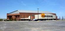
- Fargodome – indoor arena on the NDSU campus. It plays host to all NDSU home football games and is also used for concerts and trade shows. The facility also hosts the high school wrestling national freestyle and Greco-Roman championships take place every year.
- Newman Outdoor Field – Minor League Baseball stadium, host to the Fargo-Moorhead RedHawks and NDSU Bison baseball. Located at 1515 15th Ave N, Fargo on NDSU campus.
- Reineke Fine Arts Center – On the NDSU campus. The university uses the center for concerts, theatrical presentations, and other events.
- Fargo Civic Center – indoor arena used to host trade shows, sporting events, meetings, community events, concerts, and disaster relief.
- John E. Carlson Coliseum – This arena is host to the Fargo North High School and Fargo South High School hockey teams as well as the FM Jets hockey team, before the team left Fargo. The arena was built in 1968 and has previously been home to the Fargo Blazers and NDSU Club hockey teams. The arena is also for figure skating. The Coliseum hosts the largest squirt hockey tournament in the world, the Fargo Flyers Squirt International Hockey Tournament.
- Scheels Arena – On June 27, 2007, Fargo held a groundbreaking for the $25 million Urban Plains Center ice hockey arena.[41] Its first event was a Fargo Force Hockey home game on Thursday, October 30, 2008. The arena is used for the United States Hockey League's Fargo Force, Fargo high school hockey, and other concerts and special events. The Urban Plains Center was renamed Scheels Arena on October 6, 2010. The arena opened a second sheet of ice connected to the facility in June 2016.[42]
Museums
- Bonanzaville, USA – In West Fargo, North Dakota, it is a village made up of many historic buildings from the region. Includes a church, school building, and log cabins. It is named after the historic bonanza farms of the area.
- The Children's Museum at Yunker Farm – Provides many exhibits and hands-on participation for children.
- Fargo Air Museum – features aircraft from World War II and beyond. Also hosts traveling exhibits.
- Plains Art Museum – large art museum in a historic downtown building. Features regional and national exhibits.
- The Roger Maris Museum – small, free museum dedicated to Roger Maris in a wing of the West Acres Shopping Center. Features memorabilia and a video presentation about the New York Yankees player who lived in Fargo for a portion of his life.
- Maury Wills Museum – At Newman Outdoor Field the Maury Wills Museum is in honor of the former 1962 National League MVP and Major League Baseball player who worked for the RedHawks as a coach and a radio analyst.
- Hjemkomst Center – In Moorhead, MN, displays and interprets the Hjemkomst replica Viking ship that was sailed to Norway. In addition, it is home of the Clay County Historical Society museum and archives and features a replica of a Norwegian Hopperstad Stave Church.
- Rourke Art Museum – In Moorhead, Minnesota, this art museum displays fine arts.
Theaters
- Fargo-Moorhead Community Theatre presents comedies, dramas, youth shows, and musicals in a theatre in Island Park south of downtown.
- Fargo Theatre is a 1926 Art Deco movie theater which presents classic and current films, live productions, and other events.
- Main Avenue Theatre hosts live productions by local independent theater company Theatre B.
- Trollwood Performing Arts School is a summer theatre arts program for students of all ages. The school presents many different forms of performing arts every summer, the most prominent being a Broadway musical performed in front of up to 2,500 audience members per night at an outdoor amphitheater.
- The Gooseberry Park Players are a not-for profit, fee-free theatre company for individuals 11–18 years old. Every summer in late July, they present a show at the Frances Frazier Comstock Theatre on the campus of Concordia College.
- The Fargo-Moorhead Opera is a non-profit, professional opera company. It has two to three productions each year, as well as international dinners and an annual gala. It is the only professional opera company between Minneapolis, Billings, Winnipeg and Omaha.
Tallest buildings
The tallest buildings in Fargo include:
- 1 (under construction). Block 9 Tower (height: 234 ft; proposed by Kilbourne Group in 2013; construction began 2018, 18 floors)[43][44][45][46]
- 2. Radisson Hotel (height: 206 ft 8 in; 63 m, built 1985, 18 floors)
- 3. Lashkowitz High Rise (height: 203 ft 4 in; 62 m, built 1970, 22 floors)
- 4. Sanford Medical Center (height: 199 ft 8 in; built 2012, 11 floors)
- 5. Cathedral of St. Mary (height: 170 ft 3 in; 52 m, built 1899)
- 6. First Lutheran Church (height: 167 ft 4 in; 51 m, built 1920)
- 7. Fargodome (height: 125 ft; 38 m, built 1992)[47]
- 8. Bank of the West tower (Height 122 ft, 10 stories)
- 9. Black Building (Height: 108 ft 0 in; Built 1931) Tallest building in North Dakota from 1931 to 1934 when the new ND Capitol building was completed at 241 feet high, which as of April 2016, remains the tallest building in the state today
Miscellaneous attractions
- Newman Outdoor Field – home of the Fargo-Moorhead RedHawks (an independent professional baseball team that is part of the American Association).
- North Dakota Horse Park – features live racing and betting.
- Red River Zoo – 30-acre (12 ha) zoo that features 80 species of animals. Also includes a restored 1928 carousel.[48]
- Fargo Outdoor Skate Park – outdoor skate park at the Dike West.
- West Acres Shopping Center – home to more than 120 stores that encompass approximately 950,000 square feet.[49]
See also
- Fargo-Moorhead Toll Bridge
- Hector International Airport
- National Register of Historic Places listings in Cass County, North Dakota – with more than 20 Fargo properties
- Roman Catholic Diocese of Fargo
- USS Fargo, a United States Navy vessel named after the city
Notes
- Mean monthly maxima and minima (i.e. the highest and lowest temperature readings during an entire month or year) calculated based on data at said location from 1981 to 2010.
- Official records for Fargo were kept at the Weather Bureau Office in Moorhead, Minnesota from January 1881 to January 1942, and at Hector Int'l since February 1942. For more information, see ThreadEx
References
- "US Gazetteer files 2010". United States Census Bureau. Archived from the original on January 25, 2012. Retrieved June 14, 2012.
- "Population and Housing Unit Estimates". Retrieved May 23, 2019.
- "US Board on Geographic Names". United States Geological Survey. October 25, 2007. Retrieved January 31, 2008.
- Based on 2018 population estimate numbers. 124,844 (Fargo pop.) / 760,077 (ND pop.) = 13.01%
- "2010 Census Redistricting Data (Public Law 94-171) Summary File – Place". American FactFinder. United States Census Bureau. Retrieved April 27, 2011.
- "Annual Estimates of the Population of Metropolitan and Micropolitan Statistical Areas: April 1, 2010 to July 1, 2018" (CSV). United States Census Bureau. July 2013. Retrieved May 23, 2019.
- John Eligon (April 2, 2013). "Sandbag Season Has Fargo Thinking of a Better Way". The New York Times. Retrieved April 3, 2013.
"When you have a 100-year flood four years out of five, that's a great challenge," Gov. Jack Dalrymple said.
- Riley, G (1991). Divorce: An American Tradition. Oxford University Press
- http://library.ndsu.edu/fargo-history/?q=content/fire-1893 Archived July 5, 2015, at the Wayback Machine
- Clymer, Floyd. Treasury of Early American Automobiles, 1877–1925 (New York: Bonanza Books, 1950), p.205.
- Jackson, William (2008). Almanac of North Dakota mysteries & oddities, 2009–2010. Valley Star Books. p. 14. ISBN 9780967734989. OCLC 259419005.
- "Tetsuya Theodore Fujita: 1920–1998". The Tornado Project. Retrieved February 28, 2011.
- Fargo lifts the ban on building permits in flood prone areas | WDAY | Fargo, ND Archived February 17, 2013, at Archive.today. WDAY (November 8, 2012). Retrieved on August 25, 2013.
- "USDA Plant Hardiness Zone Map". United States Department of Agriculture. Archived from the original on February 27, 2014. Retrieved April 12, 2018.
- "NowData – NOAA Online Weather Data". National Oceanic and Atmospheric Administration. Retrieved April 12, 2018.
- "Thread Stations Extremes". National Oceanic and Atmospheric Administration. Retrieved September 13, 2011.
- "America's Toughest Weather City Champion". weather.com. Archived from the original on June 11, 2013. Retrieved July 12, 2017.
- "Station Name: ND FARGO HECTOR INTL AP". National Oceanic and Atmospheric Administration. Retrieved March 13, 2014.
- "WMO Climate Normals for FARGO/WSO AP ND 1961–1990". National Oceanic and Atmospheric Administration. Retrieved March 10, 2014.
- "Fargo, North Dakota, USA – Monthly weather forecast and Climate data". Weather Atlas. Retrieved July 4, 2019.
- United States Census Bureau. "Census of Population and Housing". Retrieved July 21, 2013.
- "Population Estimates". United States Census Bureau. Retrieved June 8, 2018.
- "U.S. Census website". United States Census Bureau. Retrieved June 14, 2012.
- "Fargo, ND Income and Careers". USA.com.
- "Archived copy". Archived from the original on May 22, 2015. Retrieved May 13, 2015.CS1 maint: archived copy as title (link)
- "Group trying to recall Fargo Commissioner Piepkorn over his refugee stance submits petition for state review".
- "Refugee backers drop effort to recall Fargo commissioner".
- "Fargo to become first city in U.S. to use approval voting". Archived from the original on November 11, 2018. Retrieved November 10, 2018.
- "Official Election Results – Cass County". North Dakota Secretary of State. Archived from the original on July 28, 2011. Retrieved October 4, 2010.
- https://www.casscountynd.gov/home/showdocument?id=398
- "Secretary of State – Election Night Results – November 8th, 2016". results.sos.nd.gov.
- "Best Small Places For Business And Careers: #1 Fargo ND - Forbes.com". Forbes. July 23, 2014. Retrieved September 17, 2014.
- "City of Fargo 2014 Comprehensive Annual Financial Report" (PDF). June 29, 2015. p. 156. Archived from the original (PDF) on September 6, 2015. Retrieved February 28, 2016.
- "Fargo Library breaks record".
- "Fargo: Zoznam partnerských miest: Mesto Martin". www.martin.sk.
- Fargo Monthly
- "Overview".
- "Empire Builder" (PDF). amtrak.com. Retrieved October 28, 2014.
- "2016–2020 Transit Development Plan" (PDF). Fargo-Moorhead Metropolitan Council of Governments. December 2016. Archived from the original (PDF) on June 23, 2018.
- "Facility Guide 2017" (PDF). Scheels Arena. Archived from the original (PDF) on April 28, 2018. Retrieved April 27, 2018.
- "Added ice sheet to Scheels Arena to open in June". INFORUM. Retrieved April 27, 2018.
- "Developer: Downtown Fargo's Block 9 tower financing almost done, groundbreaking this summer".
- Inc., Midwest Communications. "Partnership announces downtown development plan". KFGO-790.
- "Fargo skyscraper project has hotel, office partners; city help..."
- Tran, Tu-Uyen. "High winds, fireproofing, water pressure require special attention for 234-foot, 25,000-ton Block 9 tower". Inforum.
- "Fargo: Buildings of the City". Emporis. Archived from the original on February 24, 2007. Retrieved February 28, 2011.
- Robin McMacken (June 2008). The Dakotas Off the Beaten Path (7th ed.). p. 183. ISBN 978-0762747726.
- "Mall in Fargo, Shopping in Fargo ND – West Acres Mall". www.westacres.com. Archived from the original on October 4, 2016. Retrieved September 16, 2016.
Bibliography
External links
| Wikimedia Commons has media related to Fargo, North Dakota. |
| Wikivoyage has a travel guide for Fargo, North Dakota. |
| Wikisource has the text of the 1911 Encyclopædia Britannica article Fargo. |
- Official website
- Fargo Visitors Bureau – exists to promote Fargo, North Dakota as a destination for visitors
- Downtown Fargo-Moorhead – Downtown's premiere site for dine, shop, play, events, entertainment and more.
- James Lileks' Fargo – website with many pictures of historic Fargo
- Fargo, North Dakota Geology – website about the geology of the Fargo area
- Fargo, North Dakota at Curlie
- A century together : a history of Fargo, North Dakota, and Moorhead, Minnesota (1975) from the Digital Horizons website
- Fargo : the natural location for agricultural industry (1946) from the Digital Horizons website
- Green pastures and vast wheat fields : a sketch, historical, descriptive and statistical (1975) from the Digital Horizons website
Articles relating to Fargo, North Dakota | |||||||||||||||||||||||||||||||||||||||||||||||||||||
|---|---|---|---|---|---|---|---|---|---|---|---|---|---|---|---|---|---|---|---|---|---|---|---|---|---|---|---|---|---|---|---|---|---|---|---|---|---|---|---|---|---|---|---|---|---|---|---|---|---|---|---|---|---|
| |||||||||||||||||||||||||||||||||||||||||||||||||||||
| Authority control |
|
|---|