Wellington station (MBTA)
Wellington is a rapid transit station in Medford, Massachusetts. It serves the MBTA's Orange Line. It is located on the Revere Beach Parkway (Route 16), slightly east of its intersection with Route 28. Wellington functions as a park and ride with more than 1,300 spaces, and a bus hub with 10 routes terminating at the station. The Station Landing development, connected to the station by an overhead walkway, includes residential and retail buildings and additional parking.
Wellington | |||||||||||
|---|---|---|---|---|---|---|---|---|---|---|---|
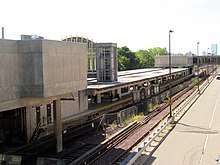
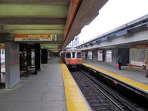 An outbound train leaves Wellington. | |||||||||||
| Location | Revere Beach Parkway and Rivers Edge Drive Medford, Massachusetts | ||||||||||
| Coordinates | 42.401907°N 71.077096°W | ||||||||||
| Owned by | MBTA | ||||||||||
| Line(s) | Haymarket North Extension | ||||||||||
| Platforms | 2 island platforms | ||||||||||
| Tracks | 3 (2 in regular service) | ||||||||||
| Connections | |||||||||||
| Construction | |||||||||||
| Parking | 1,316 spaces ($9.00 daily) | ||||||||||
| Bicycle facilities | 16 spaces | ||||||||||
| Disabled access | Yes | ||||||||||
| History | |||||||||||
| Opened | September 6, 1975 | ||||||||||
| Traffic | |||||||||||
| Passengers (2013) | 7,609 (weekday average boardings)[1] | ||||||||||
| Services | |||||||||||
| |||||||||||
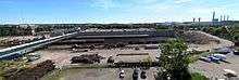
Wellington Carhouse, the primary repair and maintenance facility for the Orange Line, is located adjacent to the station. The 125,000 square feet (11,600 m2) building can hold three-and-a-half six-car trains.[2]
Station layout
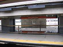
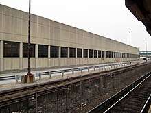
Wellington station has two island platforms between the three Orange Line tracks. The western platform serves both inbound (southbound) and outbound trains, while the eastern platform is used only for outbound trains. It was intended for use by express trains using the third track; however, the planned extension to Reading was cut back to Oak Grove and no express trains were ever run. The fare mezzanine is located over the north end of the station. The busway and parking lot are located on the east side of the station.
Wellington Yard, the primary maintenance and storage facility for the Orange Line fleet, is located west of the station. A parking garage shared by the station and the Station Landing development is west of the yard. It is connected to the fare mezzanine with a 800-foot (240 m)-long enclosed walkway. Wellington station is fully accessible from both entrances, with elevators connecting the mezzanine to the platforms.
A footbridge at the south end of the station connects only to the maintenance facility and is not in public use. The MBTA plans to rebuild it as a public entrance, with a footbridge to the east parking lot. A design contract was awarded in April 2020.[3]
| M | Mezzanine | Fare control, walkway to parking garage |
| G | Street level | Exit/entrance, buses, parking lot |
| P Platform level |
Southbound | ← Orange Line toward Forest Hills (Assembly) |
| Island platform | ||
| Northbound | Orange Line toward Oak Grove (Malden Center) → | |
| Island platform | ||
| Third track | No regular service | |
| Commuter | ← Haverhill Line does not stop here → | |
History
Boston and Maine station
The Boston and Maine Railroad's Western Route main line was built through the east side of what is now Medford in 1845, and the Medford branch from Medford Junction to Medford Square opened in 1847.[4] Wellington station, located between 5th Street and 6th Street about 0.2 miles (0.32 km) to the south of Medford Junction, served as the connection between the mainline and the Medford branch.[4][5][6] The station was originally located in Everett; the east tract of Wellington Farm, including the station area, was annexed to Medford in 1875.[7][8] By the 1920s, Wellington station was a two-story wooden building located on the west side of the tracks.[9] The station served only Medford Branch local service by the 1940s; it closed with the end of passenger service on the branch on October 1, 1957.[10][11][12]
Modern station
Unlike the Washington Street Elevated which was built as the same time with a similar design, the Charlestown El was located very near Boston Harbor and the Mystic River tidal estuary, and was thus continually exposed to accelerated corrosion caused by salt air. The elevated was also unpopular with many local residents, as it was noisy and blocked out sunlight to Main Street. In the 1960s, it was determined that a replacement elevated would not be wise to build, and that a full-length replacement tunnel would be too expensive.
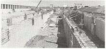
Instead, the Haymarket North Extension project consisted of a tunnel segment from Haymarket near Boston's downtown through a new underground stop at North Station, then under the Charles River to a portal near Community College. From there the extension was built along the Haverhill Line commuter rail right of way, lowering land acquisition difficulties.
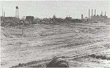
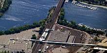
When planning the line in the mid-1960s, the MBTA decided that the 40-acre Wellington Dump site, located south of the previous station sites, was the best location for a rapid transit stop to serve the east part of Medford. The new site provided ample room for parking and bus transfer areas, as well as a maintenance depot to replace the Sullivan Square shops (which were being torn down with the Elevated), plus easy access to Route 16 and Route 28.[13]
Wellington Yard opened on July 15, 1975, followed by the station on September 6, as part of the second phase of the Haymarket North Extension.[14][15] Wellington was the first station on the line to serve an area that had not previously had rapid transit, unlike Sullivan Square and Community College which approximately replaced former elevated stations. Wellington was the northern terminus of the Orange Line until Malden Center opened on December 27, 1975, and some trains terminated at Wellington until Oak Grove opened on March 20, 1977.[15] From February 1 to December 16, 1981, Malden Center and Oak Grove stations were closed on Sundays as part of systemwide austerity program. Wellington was the northern terminus of the line on these days, with a bus shuttle run to the closed stations.[15]
Wellington station was not originally accessible. Addition of elevators at Wellington and Sullivan Square began in 1991.[14][16]
Development
In 1969, Mayor and State Representative John McGlynn sponsored the first of two bills to permit air rights development over the station and Route 16. The same year, Medford received a letter of agreement from the MBTA to build a parking garage over the tracks and the planned maintenance facility to free up development space.[13]
After city-done studies of population and land use, the Massachusetts Department of Public Works and the Federal Highway Administration held a study of several development options for Wellington, which would have involved air rights construction directly over the station. Options considered in this 1976 report included a minimum residential/transit deck, a moderate residential/transit garage, or a full-build shopping center, office, residential, nursing home, and transit garage. These plans also called for the 16/28 intersection to be partially grade separated, and a traffic circle to replace the blind underpass used for automobile and bus access to the station.[13]
Based on this study, the city of Medford continued to pursue development at Wellington. The preferred alternative in the 1981 Final Environmental Impact Statement included a parking garage built above the carhouse and rail yard, additional parking and a retail mall between the yard and Route 28, hotel and office space over the original parking lots, and condominiums and elderly housing northeast of the 16/28 intersection. Route 16 would have been placed in an underpass at the intersection, the ramps from 16 to the station parking improved, and a full park built along the riverfront.[17]
However, the planned developments were only partially built, and none of the planned interchange improvements came to fruition. The first new construction was several office buildings in the northeast parcel in the early 1990s, followed by the Wellington Garage west of the rail yard in 1997. The MBTA agreed to lease 950 spaces of the 1350-space, 9-level garage for 15 years, after which the MBTA took ownership of 600 of the spaces and the remainder reverted to the developer.[18] The Station Landing complex, envisioned as new urbanist transit-oriented development, was constructed over much of that time period, finishing around 2012. The project included 600 condominiums in a 12-story complex, 125,000 square feet (11,600 m2) of retail space (with the possibility of over 1 million square feet at full build), and an expansion of the garage to 1900 spaces.[19][20] Some of the property fronting the Mystic River has been turned into parkland; the first three of four stages of the 1.3 miles (2.1 km) Wellington Greenway opened in November 2012. The trail, funded by the Massachusetts Environmental Trust and developers Preotle, Lane & Associates, runs partially along the embankment of the Haverhill Line's former Mystic River drawbridge.[21]
People mover
In May 1996, construction began on an automated people mover to connect the station with the Mystic Center (later "Station Landing") office complex and park and ride. Completed in October 1997 at a cost of $2.9 million, the 760-foot-long (230 m) "horizontal elevator" was designed to carry 1,000 commuters a day at speeds up to 25 mph (40 km/h)[22] taking about 55 seconds to travel end to end.[23]
Constructed by Poma-Otis Transportation Systems, a joint venture of Poma and the Otis Elevator Company, the people mover consisted of a pair of independent cable-hauled cars on two parallel tracks. Unlike other Otis-built people movers, which float on a cushion of air, the Wellington people mover was the first by Otis to run on steel rails.[24] Each eight-seat glass sided car could carry up to 45 passengers or 7,200 pounds (3,300 kg) resulting in a maximum capacity of 1,600 people per hour per direction.[24] Riders entered and exited from pairs of sliding doors on the ends of the carriages, with a third door providing access to the emergency walkway between the two tracks.
The people mover was plagued by mechanical problems, which resulted in both high maintenance costs and low reliability. The frequent breakdowns and service outages frustrated riders to such an extent that 91% of users preferred replacing the people mover with a walkway, according to a 2004 survey of 240 Wellington commuters conducted by National Development, owners of the Station Landing property.[25]
In August 2006, less than ten years after it first opened, the people mover was demolished, and an above-ground covered walkway was constructed on top of the existing viaduct structure. Off-site fabrication of parts was used to speed construction of the enclosed walkway,[25] while a temporary shuttle-bus connected commuters to the parking structure during the construction.[26] The replacement walkway, named SkyWalk, cost $3 million to construct, and opened in March 2007.
Future
Wellington station was also a proposed stop on the MBTA's planned Urban Ring Project.[27] The Urban Ring was to be a Bus Rapid Transit (BRT) Line designed to connect the current MBTA Lines to reduce strain on the downtown stations. The project was cancelled in January 2010.[28]
Bus connections
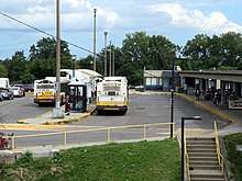
Wellington is a major MBTA Bus transfer station, with service to Medford, Everett, Malden and other surrounding cities. Most buses serve the station via a dedicated two-lane busway on the eastern side of the station, which has easy access to Route 16. The following routes serve Wellington:
- 97: Malden Center Station - Wellington Station
- 99: Woodland Road - Wellington Station
- 100: Elm Street - Wellington Station
- 106: Lebanon Loop - Wellington Station
- 108: Linden Square - Wellington Station
- 110: Wonderland Station - Wellington Station
- 112: Wellington Station - Wood Island Station
- 134: North Woburn - Wellington Station
- 710: North Medford - Wellington Station
References
- "Ridership and Service Statistics" (PDF) (14th ed.). Massachusetts Bay Transportation Authority. 2014.
- Moskowitz, Eric (July 8, 2012). "MBTA mechanics keep old subway cars rolling". Boston Globe. Retrieved September 25, 2012.
- Schwarz, John (April 13, 2020). "MBTA Contract Nos. A90PS02, A90PS04, & A90PS05: Architectural and Engineering Services for Station and Accessibility Improvements" (PDF). Massachusetts Bay Transportation Authority.
- Karr, Ronald Dale (1995). The Rail Lines of Southern New England. Branch Line Press. pp. 236–239, 242. ISBN 0942147022.
- Map showing horse rail roads and the surface steam roads with 104 stations in and around Boston, including 91 surface steam R.R. stations within a radius of six miles from City Hall, J.H. Bufford's Sons, 1876 – via Wikimedia Commons
- "Everett". County Atlas of Middlesex Massachusetts. F.W. Beers & Co. 1875 – via Ward Maps.
- Hooper, John H. (1906). Proceedings of the Celebration of the Two Hundred and Seventy-fifth Anniversary of the Settlement of Medford, Massachusetts, June, Nineteen Hundred and Five. The Executive Committee. p. 9 – via Google Books.
- "Appendix A: Mapping". City of Medford Open Space & Recreation Plan Update 2011 (PDF). City of Medford. 2011. p. Map A: Historic Community Map.
- "Wellington station, Medford, Mass., Nov. 17, 1928". Harry A. Frye Collection. Boston & Maine Railroad Historical Society. November 17, 1928.
- Northern New England Travel Guide. Boston and Maine Railroad. April 28, 1946. pp. 14–15 – via Wikimedia Commons.
- "B&M Told to Up Earnings Or Face Control by Court". Boston Globe. August 3, 1957 – via Newspapers.com.

- Middlesex County Court (April 3, 1962). "CITY OF MEDFORD vs. MARINUCCI BROS. & CO., INC. & another". Commonwealth of Massachusetts: Massachusetts Cases.
- Sasaki Associates & Gladstone Associates (February 1976). A Feasibility Study for Joint Use, Fringe Parking and Highway Improvements Related to Wellington Station. Massachusetts Department of Public Works.
- Sanborn, George M. (1992). A Chronicle of the Boston Transit System. Massachusetts Bay Transportation Authority – via Massachusetts Institute of Technology.
- Belcher, Jonathan. "Changes to Transit Service in the MBTA district" (PDF). NETransit.
- Massachusetts Bay Transportation Authority (April 30, 1991). "Notice to Bidders". Boston Globe. p. 60 – via Newspapers.com.
- Final Environmental Impact Statement/Report: Wellington Station Area Development. City of Medford Office of Community Development. April 1981.
- "Case Studies: Wellington Garage". Cabot, Cabot & Forbes. 2012. Retrieved January 10, 2014.
- "Mode Shift and Transit Oriented Development" (PDF). Massachusetts Bay Transportation Authority. October 17, 2012. Retrieved January 10, 2014.
- Reardon, Tim; Dutta, Meghna (June 2012). "Growing Station Areas: The Variety and Potential of Transit Oriented Development in Metro Boston" (PDF). Metropolitan Area Planning Council. p. 25. Retrieved January 10, 2014.
- Laidler, John (November 17, 2012). "New path along Mystic and Malden rivers gives walkers, bicyclists room to roam". Boston Globe. Retrieved January 10, 2014.
- Richards, Brian (2001). Future Transport in Cities. Taylor & Francis. p. 130. ISBN 978-0-415-26142-5.
- "Mystic Transportation Center at Wellington Station" (PDF). Transreport. Boston Metropolitan Planning Organization (Winter): 3. 1998. Retrieved October 18, 2009.
... opened in October 1997. ... The glassed-in shuttle ride between the garage and Wellington Station takes about 55 seconds.
- Fabian, Lawrence (November–December 1997). "Boston's New Automated Peoplemover". Mass Transit: 19.
- "Wellington People Mover to be replaced with walkway". Malden Observer. June 1, 2006. Retrieved June 1, 2011.
- Santoro, Phil (May 18, 2006). "T commuters will walk the line". Boston Globe. Retrieved October 18, 2009.
- "Urban Ring Phase 2 FACT SHEET" (PDF). January 2009. Archived from the original (PDF) on July 8, 2011. Retrieved March 18, 2012.
- Mullan, Jeffery B. (January 22, 2010). "Re: Urban Ring Phase 2, EOEEA #12565" (PDF). Massachusetts Executive Office of Energy and Environmental Affairs.
External links
| Wikimedia Commons has media related to Wellington station (MBTA). |