Bowdoin station
Bowdoin (/ˈboʊdɪn/) is a rapid transit station in Boston, Massachusetts. It serves the MBTA Blue Line. It is located in Bowdoin Square in the Beacon Hill neighborhood. It is the downtown terminus of the line (though Government Center served this role during nights and weekends from 1982 to 2014).
Bowdoin | |||||||||||
|---|---|---|---|---|---|---|---|---|---|---|---|
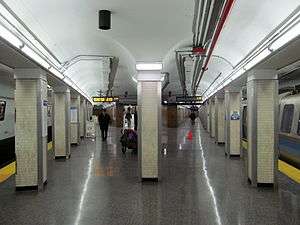 Wedge-shaped island platform at Bowdoin station | |||||||||||
| Location | Cambridge Street at New Chardon and Bowdoin Streets Boston, Massachusetts | ||||||||||
| Coordinates | 42.3614°N 71.0622°W | ||||||||||
| Owned by | Massachusetts Bay Transportation Authority | ||||||||||
| Line(s) | East Boston Tunnel | ||||||||||
| Platforms | 1 wedge-shaped island platform | ||||||||||
| Tracks | 2 | ||||||||||
| Connections | |||||||||||
| History | |||||||||||
| Opened | March 18, 1916[1] | ||||||||||
| Closed | January 3, 1981 - January 11, 1982 March 3, 1982 - April 20, 1982[1] | ||||||||||
| Traffic | |||||||||||
| Passengers (2013) | 1,526 (weekday average boardings)[2] | ||||||||||
| Services | |||||||||||
| |||||||||||
Bowdoin station is the only heavy rail station on the MBTA subway system that is not accessible.[2]
History
The East Boston Tunnel was opened to streetcar service as far as Court Street on December 30, 1904.[1] Court Street proved to be a problematic terminus; its single-track design limited frequent service, and also resulted in crashes. The Boston Elevated Railway (BERy) began an extension towards Beacon Hill in 1912.[3]:39 The extension opened to Bowdoin with an intermediate stop at Scollay Under on March 18, 1916.[1]
Bowdoin was built with an unusual wedge-shaped island platform inside a balloon loop, which eliminated the awkward end-changing required at Court Street[4]:30 and allowed use of unpowered trailer cars in the tunnel to increase capacity.[5] A pair of tracks continued past the loop, out the Joy Street Portal, and down Cambridge Street, allowing for one route to provide through streetcar service from East Boston to Cambridge rather than looping at Bowdoin.[5]
Modifications
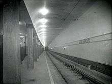
Over the weekend of April 18 to 21, 1924, the East Boston Tunnel was converted from streetcar use to high-floor rapid transit operation.[1][4]:30 Rather than modify the tunnel, the BERy elected to build smaller-than-usual rapid transit cars which could operate in a tunnel designed for streetcars—particularly around the tight loop at Bowdoin.[4]:32 Blue Line cars are thus 48.5 feet (14.8 m) long, substantially shorter than the 65-foot (20 m) Orange Line cars and the 69.5-foot (21.2 m) Red Line cars.[6] Bowdoin is the only remaining loop in regular service on the MBTA's heavy rail lines, though Red Line trains can loop around Codman Yard past Ashmont station if necessary.
Because the line did not have a dedicated maintenance facility, trains used the Joy Street Portal to reach surface tracks on the Longfellow Bridge, which connected to the Cambridge Tunnel and the Eliot Shops near Harvard Square.[4]:32 When the first phase of the Revere Extension opened to Orient Heights with a new facility in 1952, the connection was no longer necessary and the portal was filled.[4]:52 The tail tracks past the Bowdoin loop are still used for train storage during the winter, however.
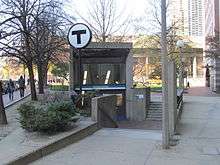
The station was modernized in 1968 as part of a $9 million systemwide station improvement program.[7] The original headhouse was replaced with a glassy entrance under a tilted concrete slab, set into a shallow depression to reduce the costs of installing the escalator. The new headhouse was designed by Josep Lluís Sert as part of a project for a never-built Catholic chapel nearby.[8]
Closures and reopening
In the early 1980s, the MBTA suffered from a serious budget crisis, which resulted in service cuts. MBTA Commuter Rail service to Providence and Concord and on the Woburn Branch were cut entirely, five underused commuter rail stations were closed, Boylston and Essex were closed for short periods, and the outer ends of the Orange and Blue lines were bustituted on Sundays.[1] Bowdoin, with low ridership and in close proximity to Government Center, was closed on January 3, 1981 due to budget cuts.[9][1] It reopened on January 11, 1982, but only on weekdays until 6:30 pm - intended to serve workers in nearby office and government buildings. Bowdoin was briefly closed again from March 3 to April 20, 1982, and reopened again with limited hours, with Government Center serving as the terminus on nights and weekends (though trains continued to loop at Bowdoin).[1]
The station was closed from July 29 to September 8, 1992, during track work on the loop.[1] As the MBTA planned the Blue Line Modernization Project in the early 1990s, the agency planned to close Bowdoin in order to eliminate the tight loop. The closure would take place after the renovation of Government Center, which would re-add a long-closed entrance at the west end of the Blue Line platform.[10] In 2008, the MBTA began running six-car trains on the Blue Line.[11] Because the eastbound side of the Bowdoin platform can only fit four cars, the trains have pushbuttons to allow passengers at Bowdoin to open the doors from the platform.
Until at least 2011, the MBTA still planned to close the station after Government Center was renovated.[12] However, by 2013, the MBTA decided not to construct the planned west entrance at Government Center, and to instead build only a less-expensive emergency exit.[13] On December 28, 2013, the MBTA resumed night and weekend service to Bowdoin station. The change was intended to provide alternative transportation during the three-month closure of the Callahan Tunnel and subsequent two-year closure of Government Center station.[14] This was the first time since 1981 that the station was open during all operating hours.[1] In February 2016, the MBTA announced that Bowdoin would remain open at all times even after Government Center reopened on March 21.[15]
References
- Belcher, Jonathan. "Changes to Transit Service in the MBTA district" (PDF). NETransit.
- "Ridership and Service Statistics" (PDF) (14th ed.). Massachusetts Bay Transportation Authority. 2014.
- Clarke, Bradley H.; Cummings, O.R. (1997). Tremont Street Subway: A Century of Public Service. Boston Street Railway Association. ISBN 0938315048.
- Cudahy, Brian J. (1972). Change at Park Street Under; the story of Boston's subways. Brattleboro, Vt.: S. Greene Press. ISBN 978-0-8289-0173-4.
- "Boston Profits By Elevated Railway Station Improvements". Electric Railway Journal. McGraw-Hill. 48 (7): 258–263. 12 August 1916 – via Internet Archive.
- "The MBTA Vehicle Inventory Page". NETransit. 12 February 2016. Retrieved 12 February 2016.
- Fourth Annual Report (Covering the period October 1, 1967 - October 31, 1968) of the Board of Directors of the Massachusetts Bay Transportation Authority. Massachusetts Bay Transportation Authority. 1968. p. 23 – via Internet Archive.
- Yudis, Anthony (December 4, 1966). "'Sunken' Subway Kiosk Proposed". Boston Globe. p. 40 – via Newspapers.com.

- "Bowdoin, Symphony T stations closed today". Boston Globe. January 3, 1981 – via Newspapers.com. (second page)
- Blake, Andrew (March 20, 1994). "MBTA to begin $467 million Blue Line project". Boston Globe – via Newspapers.com. (second page)
- "Six-Car Trains on the Blue Line" (Press release). Massachusetts Bay Transportation Authority. September 15, 2008.
- Moskowitz, Eric (October 5, 2011). "MBTA board OK's millions for station improvements". Boston Globe.
- "Government Center Station Reconstruction Project Green Line / Blue Line Project Briefing" (PDF). Massachusetts Bay Transportation Authority. March 13, 2013. Archived from the original (PDF) on April 30, 2013.
- "Callahan Tunnel closes Friday night at 11pm" (Press release). Massachusetts Bay Transportation Authority. December 23, 2013.
- Vaccaro, Adam (February 10, 2016). "Bowdoin T station will remain open nights, weekends when Government Center reopens". Boston Globe.
External links
| Wikimedia Commons has media related to Bowdoin station. |