Ruggles station
Ruggles is an intermodal transfer station in Boston, Massachusetts. It serves MBTA rapid transit, bus, and commuter rail services and is located at the intersection of Ruggles and Tremont streets, where the Roxbury, Fenway-Kenmore and Mission Hill neighborhoods meet. It is surrounded by the campus of Northeastern University.
Ruggles | ||||||||||||||||||||||||
|---|---|---|---|---|---|---|---|---|---|---|---|---|---|---|---|---|---|---|---|---|---|---|---|---|
.jpg) Orange Line and commuter rail trains at Ruggles | ||||||||||||||||||||||||
| Location | Ruggles Street at Tremont Streets Roxbury, Boston, Massachusetts | |||||||||||||||||||||||
| Coordinates | 42°20′10″N 71°05′22″W | |||||||||||||||||||||||
| Owned by | Massachusetts Bay Transportation Authority | |||||||||||||||||||||||
| Line(s) | Northeast Corridor (Southwest Corridor) | |||||||||||||||||||||||
| Platforms | 1 island platform (Orange Line) 1 island platform (Northeast Corridor) | |||||||||||||||||||||||
| Tracks | 2 (Orange Line) 3 (Northeast Corridor) | |||||||||||||||||||||||
| Connections | ||||||||||||||||||||||||
| Construction | ||||||||||||||||||||||||
| Bicycle facilities | 12 spaces | |||||||||||||||||||||||
| Disabled access | Yes | |||||||||||||||||||||||
| Other information | ||||||||||||||||||||||||
| Fare zone | 1A (Commuter Rail) | |||||||||||||||||||||||
| History | ||||||||||||||||||||||||
| Opened | May 4, 1987 (Orange Line)[1] October 5, 1987 (Commuter Rail)[1] | |||||||||||||||||||||||
| Traffic | ||||||||||||||||||||||||
| Passengers (2018) | 2,640 daily boardings[2] (Commuter Rail) | |||||||||||||||||||||||
| Passengers (2013) | 12,433 daily boardings[3] (Orange Line) | |||||||||||||||||||||||
| Services | ||||||||||||||||||||||||
| ||||||||||||||||||||||||
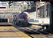
Ruggles is a station stop for the Orange Line subway, as well as the Providence/Stoughton Line, Franklin Line, and Needham Line of the MBTA Commuter Rail system. Thirteen bus routes stop at Ruggles, including four of the fifteen key MBTA bus routes.
Station layout
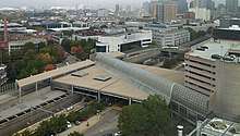
The sprawling station is elevated above the Southwest Corridor north of Ruggles Street and west of Columbus Avenue - the former location of the South End Grounds. The main station structure is a rectangular "tubular-framed, high-tech" canopy.[4] The arched concourse crosses at an angle aligned with Forsyth Street, with entrances at both ends. A clockwise busway wraps around the station, with separate entrances and exits on Ruggles Street, plus an entrance from Melnea Cass Boulevard at Columbus Avenue. The north (upper) part of the busway is level with the concourse and used for drop-offs; the south (lower) part has multiple lanes and bus berths for boarding. A Northeastern University architecture studio is located in the station structure under the upper busway, next to the Fosyth Street entrance.[5]
A total of five tracks run through the station: two for the Orange Line and three for commuter rail (and Amtrak, which does not stop). The Orange Line tracks serve a single island platform on the north side of the railroad cut. The northern two of the mainline tracks serve a second island platform, while the southernmost track has no platform.[6][7] The entrances to the two platforms are located on the west side of the concourse, under the canopy. Four elevators connect the concourse level to the two platforms, the busway, and the Forsyth Street entrance.
| G | Street level | Exit/entrance, station house, Orange Line fare control, buses, parking |
| P Platform level |
Southbound | ← Orange Line toward Forest Hills (Roxbury Crossing) |
| Island platform | ||
| Northbound | Orange Line toward Oak Grove (Massachusetts Avenue) → | |
| Track 3 | ← Needham Line toward Needham Heights (Forest Hills) ← Providence/Stoughton, Franklin lines toward points south (Hyde Park) → | |
| Island platform | ||
| Track 1 | Needham, Providence/Stoughton, Franklin lines toward South Station (Back Bay) → ← Amtrak services do not stop here → | |
| Track 2 | ← Amtrak services do not stop here → | |
History
Ruggles station opened on May 4, 1987 and was built as part of an Orange Line realignment project which relocated the former Washington Street Elevated Orange Line service into the Southwest Corridor. Commuter rail service to the station began on October 5, 1987.[1] Located where there had not previously been a station, Ruggles was built to serve Northeastern University and the Longwood Medical Area, and to replace Dudley Square station as a major bus terminal for the Orange Line.[7]
The busway was originally paved with asphalt, which soon eroded from the stopping and starting of buses. In 1988, the MBTA paid $430,000 to repave it with more-durable concrete.[8] The upper busway was closed for one year ending on February 6, 2006 for a $3.2 million rehabilitation.[9]
Urban Ring proposal
Ruggles was a proposed stop on the Urban Ring Project.[10] The Urban Ring was to be a circumferential Bus Rapid Transit (BRT) Line designed to connect the current radial MBTA rail lines, to reduce overcrowding in the downtown stations, but it was canceled in 2010.[11] Under draft plans released in 2008, the Urban Ring would have approached Ruggles from the west on a reserved surface right-of-way on the north side of Ruggles Street. Buses would have used the existing bus loop; the existing side access from Tremont Street would have connected to dedicated bus lanes on Melnea Cass Boulevard.[12]
Second commuter rail platform
A number of smaller projects in the corridor have been approved; among them is adding a second commuter rail platform to serve Track 2 at Ruggles, thus allowing all commuter rail trains to stop there. Currently, about 30% of trains do not stop, as reaching the platform would require crossing over to Track 1 or Track 3. The MBTA began consideration of a second platform in 1993, just six years after Ruggles opened.[7][13] A preliminary study in 2008 recommended a full-length 800-foot platform located entirely east of the busway bridge.[14]
The MBTA began holding public meetings in 2012, with the new platform now to be located next to the existing platform. It will be split in two sections connected by a short pedestrian tunnel under the busway bridge; the gap will be short enough to allow all doors on a train to still open onto the platform.[15] In September 2014, the MBTA received a $20 million TIGER grant for the project, which is estimated to cost $30 million in total. Besides the new platform, work will include lighting and security upgrades, elevator improvements, and rehabilitation of the deteriorated northern half of the existing platform, which is blocked off from use.[16]
By March 2016, the project was at 90% design and expected to reach 100% design by mid-2016, when it would be advertised for bidding. Construction was set to begin in late 2016 and last through 2018.[15] In December 2016, the MBTA Fiscal and Management Control Board approved a $1.6 million expansion of the project scope to include reconstruction of the lower busway, elevator replacements, additional station entrances, an additional busway elevator, and other accessibility improvements.[17] Bidding took place in May and June 2017; on June 26, the Board approved a $19.7 million construction contract (lower than the $22 million projected cost).[18]
A groundbreaking ceremony for the project, which is expected to cost $38.5 million in total, was held on August 22, 2017.[19][20] Construction was estimated to last from 2017 to 2019 (later revised to 2020).[17] Reconstruction of the lower busway began in April 2018.[21] Replacement of the first two of four station elevators began on November 12, 2019; the Orange Line platform will not be accessible during the project. [22]
Bus connections

Ruggles also serves as a major transfer point and terminal for MBTA Bus services. Most routes enter a deboarding platform from Ruggles Street and proceed to a below-grade boarding area which exits back onto Ruggles; some routes enter and/or exit on a side connection to Columbus Avenue and Tremont Street.
- 8: Harbor Point - Kenmore Station
- 15: Fields Corner Station or Kane Square - Ruggles Station
- 19: Fields Corner Station - Kenmore or Ruggles Station
- 22: Ashmont Station - Ruggles Station via Talbot Ave
- 23: Ashmont Station - Ruggles Station via Washington Street
- 28: Mattapan Station - Ruggles Station
- 43: Ruggles Station - Park Street Station
- 44: Jackson Square Station - Ruggles Station
- 45: Franklin Park - Ruggles Station
- 47: Central Square, Cambridge - Broadway Station
- CT2: Sullivan Square Station - Ruggles Station
- CT3: Beth Israel Deaconess Hospital - Andrew Station
References
- Belcher, Jonathan. "Changes to Transit Service in the MBTA district" (PDF). NETransit.
- Central Transportation Planning Staff (2019). "2018 Commuter Rail Counts". Massachusetts Bay Transportation Authority.
- "Ridership and Service Statistics" (PDF) (14th ed.). Massachusetts Bay Transportation Authority. 2014.
- Shand-Tucci, Douglass (1999). Built in Boston: City and Suburb, 1800-2000. University of Massachusetts Press. p. 319. ISBN 9781558492011 – via Google Books.
- McKnight, Jenna (April 6, 2016). "Boston architecture students complain about "unacceptable" studio space". Dezeen.
- Held, Patrick R. (2010). "Massachusetts Bay Colony Railroad Track Charts" (PDF). Johns Hopkins Association for Computing Machinery. Archived from the original (PDF) on 8 October 2013.
- Jacobs Edwards and Kelcey (September 11, 2008). Ruggles Station Platform Study (PDF) (Report). MASCO. pp. 13–15.
- Howe, Peter J. (July 4, 1988). "MBTA renovation to enter blue period". Boston Globe. p. 22 – via Newspapers.com.

- "Ruggles Station Busway Re-opens" (Press release). Massachusetts Bay Transportation Authority. February 6, 2006.
- "Urban Ring Phase 2 FACT SHEET" (PDF). January 2009. Archived from the original (PDF) on 8 July 2011. Retrieved 18 March 2012.
- Mullan, Jeffery B. (January 22, 2010). "Re: Urban Ring Phase 2, EOEEA #12565" (PDF). Massachusetts Executive Office of Energy and Environmental Affairs.
- "The Urban Ring Phase 2: Revised Draft Environmental Impact Report/Statement" (PDF). Massachusetts Executive Office of Transportation. November 2008. Archived from the original (PDF) on May 14, 2017.
- "MBTA Ruggles Station Commuter Rail Platform Project: Legislative Briefing September 20, 2012" (PDF). Massachusetts Bay Transportation Authority. 20 September 2012. Retrieved 16 September 2014.
- Jacobs Engineering (11 September 2008). "Ruggles Station Platform Study" (PDF). MASCO Inc. Retrieved 2 February 2012.
- "Ruggles Station Platform Project". Massachusetts Bay Transportation Authority. Archived from the original on 4 March 2016.
- "TIGER 2014 Awards" (PDF). U.S. Department of Transportation. September 2014. Retrieved 16 September 2014.
- "FMCB votes to expand design of Ruggles Station Transportation Project" (Press release). Massachusetts Bay Transportation Authority. December 19, 2016.
- "MBTA Construction Contract No. S31CN02: Ruggles Station Commuter Rail Platform Project" (PDF). Massachusetts Bay Transportation Authority. June 26, 2017.
- "Baker-Polito Administration, Federal and Local Officials Celebrate Ruggles Station Project Groundbreaking". MassDOT Blog (Press release). Massachusetts Department of Transportation. August 22, 2017.
- Heyward, Jasmine (August 22, 2017). "Work officially gets underway on Ruggles Station improvement project". Boston Globe. Retrieved August 30, 2017.
- "Lower Busway Construction" (Press release). Massachusetts Bay Transportation Authority. April 27, 2018.
- "Ruggles Elevator Closures Start in November 2019" (Press release). Massachusetts Bay Transportation Authority. October 30, 2019.
External links
| Wikimedia Commons has media related to Ruggles station. |
- MBTA - Ruggles
- MBTA - Ruggles Station Platform Project
- Google Maps Street View: Forsyth Street entrance, Ruggles Street entrance, Columbus Avenue entrance