Lost Creek, West Virginia
Lost Creek is a town in Harrison County, West Virginia, United States. The population was 496 at the 2010 census.
Lost Creek, West Virginia | |
|---|---|
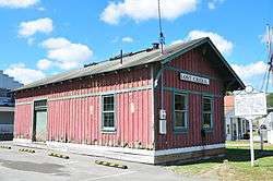 Lost Creek West Virginia Baltimore and Ohio Railroad Depot | |
 Location of Lost Creek in Harrison County, West Virginia. | |
| Coordinates: 39°9′30″N 80°20′53″W | |
| Country | United States |
| State | West Virginia |
| County | Harrison |
| Area | |
| • Total | 0.97 sq mi (2.51 km2) |
| • Land | 0.97 sq mi (2.51 km2) |
| • Water | 0.00 sq mi (0.00 km2) |
| Elevation | 1,020 ft (311 m) |
| Population | |
| • Total | 496 |
| • Estimate (2018)[3] | 471 |
| • Density | 485.07/sq mi (187.29/km2) |
| Time zone | UTC-5 (Eastern (EST)) |
| • Summer (DST) | UTC-4 (EDT) |
| ZIP code | 26385 |
| Area code(s) | 304 |
| FIPS code | 54-48748[4] |
| GNIS feature ID | 1554998[5] |
History
The town takes its name from nearby Lost Creek.[6]
The Daniel Bassel House and Lost Creek Baltimore and Ohio Railroad Depot are listed on the National Register of Historic Places.[7]
Geography
Lost Creek is located at 39°9′30″N 80°20′53″W (39.158451, -80.348165).[8] in southern Harrison County
According to the United States Census Bureau, the town has a total area of 0.97 square miles (2.51 km2), all of it land.[9]
Demographics
| Historical population | |||
|---|---|---|---|
| Census | Pop. | %± | |
| 1950 | 798 | — | |
| 1960 | 678 | −15.0% | |
| 1970 | 571 | −15.8% | |
| 1980 | 604 | 5.8% | |
| 1990 | 413 | −31.6% | |
| 2000 | 467 | 13.1% | |
| 2010 | 496 | 6.2% | |
| Est. 2018 | 471 | [3] | −5.0% |
| U.S. Decennial Census[10] | |||
2010 census
At the 2010 census there were 496 people, 185 households, and 139 families living in the town. The population density was 511.3 inhabitants per square mile (197.4/km2). There were 205 housing units at an average density of 211.3 per square mile (81.6/km2). The racial makeup of the town was 95.8% White, 0.8% African American, 0.4% Native American, 0.6% from other races, and 2.4% from two or more races. Hispanic or Latino of any race were 1.8%.[2]
Of the 185 households 37.3% had children under the age of 18 living with them, 49.7% were married couples living together, 20.0% had a female householder with no husband present, 5.4% had a male householder with no wife present, and 24.9% were non-families. 18.9% of households were one person and 8.1% were one person aged 65 or older. The average household size was 2.68 and the average family size was 2.97.
The median age in the town was 38.2 years. 27.6% of residents were under the age of 18; 3.6% were between the ages of 18 and 24; 26.3% were from 25 to 44; 28.5% were from 45 to 64; and 14.1% were 65 or older. The gender makeup of the town was 48.2% male and 51.8% female.
2000 census
At the 2000 census there were 467 people, 184 households, and 133 families living in the town. The population density was 461.4 inhabitants per square mile (178.5/km²). There were 207 housing units at an average density of 204.5 per square mile (79.1/km²). The racial makeup of the town was 98.29% White, 0.21% Asian, and 1.50% from two or more races. Hispanic or Latino of any race were 0.43%.[4]
Of the 184 households 27.2% had children under the age of 18 living with them, 52.7% were married couples living together, 15.8% had a female householder with no husband present, and 27.7% were non-families. 24.5% of households were one person and 13.6% were one person aged 65 or older. The average household size was 2.54 and the average family size was 3.00.
The age distribution was 21.8% under the age of 18, 8.8% from 18 to 24, 30.0% from 25 to 44, 23.6% from 45 to 64, and 15.8% 65 or older. The median age was 39 years. For every 100 females, there were 91.4 males. For every 100 females age 18 and over, there were 97.3 males.
The median household income was $26,563 and the median family income was $35,893. Males had a median income of $32,292 versus $19,500 for females. The per capita income for the town was $15,711. About 22.6% of families and 26.0% of the population were below the poverty line, including 36.8% of those under age 18 and 20.5% of those age 65 or over.
References
- "2018 U.S. Gazetteer Files". United States Census Bureau. Retrieved Feb 16, 2020.
- "U.S. Census website". United States Census Bureau. Retrieved 2013-01-24.
- "Population and Housing Unit Estimates". Retrieved June 4, 2019.
- "U.S. Census website". United States Census Bureau. Retrieved 2008-01-31.
- "US Board on Geographic Names". United States Geological Survey. 2007-10-25. Retrieved 2008-01-31.
- Kenny, Hamill (1945). West Virginia Place Names: Their Origin and Meaning, Including the Nomenclature of the Streams and Mountains. Piedmont, WV: The Place Name Press. p. 387.
- "National Register Information System". National Register of Historic Places. National Park Service. July 9, 2010.
- "US Gazetteer files: 2010, 2000, and 1990". United States Census Bureau. 2011-02-12. Retrieved 2011-04-23.
- "US Gazetteer files 2010". United States Census Bureau. Archived from the original on 2012-07-02. Retrieved 2013-01-24.
- "Census of Population and Housing". Census.gov. Retrieved June 4, 2015.
Municipalities and communities of Harrison County, West Virginia, United States | ||
|---|---|---|
| Cities | 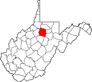 Map of West Virginia highlighting Harrison County | |
| Towns | ||
| CDPs | ||
| Unincorporated communities |
| |