Vandoncourt
Vandoncourt is a commune in the Doubs department in the Bourgogne-Franche-Comté region in eastern France.
Vandoncourt | |
|---|---|
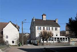 Town hall and school | |
 Coat of arms | |
Location of Vandoncourt 
| |
 Vandoncourt  Vandoncourt | |
| Coordinates: 47°28′04″N 6°54′07″E | |
| Country | France |
| Region | Bourgogne-Franche-Comté |
| Department | Doubs |
| Arrondissement | Montbéliard |
| Canton | Audincourt |
| Intercommunality | Pays de Montbéliard |
| Government | |
| • Mayor (2008–2014) | Patrice Vernier |
| Area 1 | 8.57 km2 (3.31 sq mi) |
| Population (2017-01-01)[1] | 830 |
| • Density | 97/km2 (250/sq mi) |
| Time zone | UTC+01:00 (CET) |
| • Summer (DST) | UTC+02:00 (CEST) |
| INSEE/Postal code | 25586 /25230 |
| Elevation | 370–611 m (1,214–2,005 ft) |
| 1 French Land Register data, which excludes lakes, ponds, glaciers > 1 km2 (0.386 sq mi or 247 acres) and river estuaries. | |
Geography
Vandoncourt lies 4.5 km (2.8 mi) southeast of Hérimoncourt and 7 km (4.3 mi) from the Swiss border. It occupies a transitional position between the Vosges Mountains and Alsace to the north and the Jura mountains on the south, Switzerland on the east and the plain of the Saône River on the west.
It is perched on a high plateau, which dominates the region.
Population
| Historical population | ||
|---|---|---|
| Year | Pop. | ±% |
| 1748 | 347 | — |
| 1900 | 756 | +117.9% |
| 1962 | 539 | −28.7% |
| 1968 | 557 | +3.3% |
| 1975 | 605 | +8.6% |
| 1982 | 594 | −1.8% |
| 1990 | 605 | +1.9% |
| 1999 | 626 | +3.5% |
| 2008 | 819 | +30.8% |
| 2012 | 841 | +2.7% |
See also
External links
| Wikimedia Commons has media related to Vandoncourt. |
- Vandoncourt on the regional Web site (in French)
| Authority control |
|
|---|
This article is issued from Wikipedia. The text is licensed under Creative Commons - Attribution - Sharealike. Additional terms may apply for the media files.