Nans-sous-Sainte-Anne
Nans-sous-Sainte-Anne is a commune in the Doubs department in the Bourgogne-Franche-Comté region in eastern France.
Nans-sous-Sainte-Anne | |
|---|---|
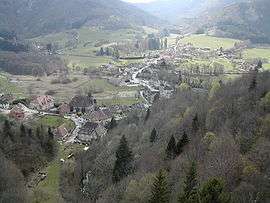 View from the Via Ferrata | |
Location of Nans-sous-Sainte-Anne 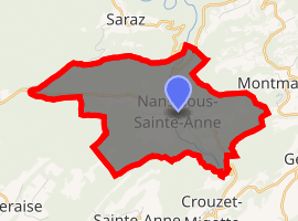
| |
 Nans-sous-Sainte-Anne  Nans-sous-Sainte-Anne | |
| Coordinates: 46°58′39″N 5°59′59″E | |
| Country | France |
| Region | Bourgogne-Franche-Comté |
| Department | Doubs |
| Arrondissement | Besançon |
| Canton | Ornans |
| Intercommunality | Canton of Amancey-Loue-Lison |
| Government | |
| • Mayor (2008–2014) | Daniel Menweg |
| Area 1 | 8.86 km2 (3.42 sq mi) |
| Population (2017-01-01)[1] | 156 |
| • Density | 18/km2 (46/sq mi) |
| Time zone | UTC+01:00 (CET) |
| • Summer (DST) | UTC+02:00 (CEST) |
| INSEE/Postal code | 25420 /25330 |
| Elevation | 357–770 m (1,171–2,526 ft) |
| 1 French Land Register data, which excludes lakes, ponds, glaciers > 1 km2 (0.386 sq mi or 247 acres) and river estuaries. | |
Geography
The commune lies 44 km (27 mi) south of Besançon on the central plateau of the Jura mountains. Nans is known for its spectacular geological features, including the Source de Lison, the Via Ferrata and the Grotte Serazin. The artist Gustave Courbet was active in the area. His depiction of the Grotte Serazin hangs in the Getty Museum in Los Angeles, California, and his painting of the Source de Lison is in the Alte Nationalegalerie in Berlin. Nans is also home to the historical Tillandiarie, a 16th-century water-powered workshop.
Population
| Historical population | ||
|---|---|---|
| Year | Pop. | ±% |
| 1962 | 88 | — |
| 1968 | 113 | +28.4% |
| 1975 | 128 | +13.3% |
| 1982 | 141 | +10.2% |
| 1990 | 142 | +0.7% |
| 1999 | 125 | −12.0% |
| 2008 | 145 | +16.0% |
| 2012 | 146 | +0.7% |
See also
External links
| Wikimedia Commons has media related to Nans-sous-Sainte-Anne. |
- Nans-sous-Sainte-Anne on the intercommunal Web site of the department (in French)
- Places to stay in Nans Sous Sainte Anne
- Residence de Vaux,
- [1] 29 Grand Rue, +33 (0)3 81 86 65 87
- A l'Ombre du Chateau, 6 Rue du Chateau, +33 (0)6 35 38 40 11
- L'Atelier des Chefs
| Authority control |
|
|---|
- "Residence de Vaux". Christine Remaud. 8 April 2015.
This article is issued from Wikipedia. The text is licensed under Creative Commons - Attribution - Sharealike. Additional terms may apply for the media files.