Arcey, Doubs
Arcey (Franc-Comtois: Airceis) is a commune in the Doubs department in the Bourgogne-Franche-Comté region in eastern France.
Arcey | |
|---|---|
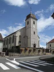 The church in Arcey | |
Location of Arcey 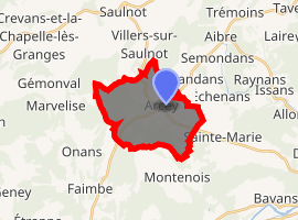
| |
 Arcey  Arcey | |
| Coordinates: 47°31′23″N 6°39′41″E | |
| Country | France |
| Region | Bourgogne-Franche-Comté |
| Department | Doubs |
| Arrondissement | Montbéliard |
| Canton | Bavans |
| Intercommunality | Vallée du Rupt |
| Government | |
| • Mayor (2008–2014) | Claude Clément |
| Area 1 | 12.57 km2 (4.85 sq mi) |
| Population (2017-01-01)[1] | 1,441 |
| • Density | 110/km2 (300/sq mi) |
| Time zone | UTC+01:00 (CET) |
| • Summer (DST) | UTC+02:00 (CEST) |
| INSEE/Postal code | 25022 /25750 |
| Elevation | 347–490 m (1,138–1,608 ft) |
| 1 French Land Register data, which excludes lakes, ponds, glaciers > 1 km2 (0.386 sq mi or 247 acres) and river estuaries. | |
Geography
Arcey is located in the northeast of Bourgogne-Franche-Comté, about 12 km from Montbéliard, about 30 km (19 mi) from Belfort, about 60 km (37 mi) from Besançon, and about 25 km from the Swiss border.
Population
| Historical population | ||
|---|---|---|
| Year | Pop. | ±% |
| 1962 | 489 | — |
| 1968 | 652 | +33.3% |
| 1975 | 917 | +40.6% |
| 1982 | 1,071 | +16.8% |
| 1990 | 1,101 | +2.8% |
| 1999 | 1,174 | +6.6% |
| 2008 | 1,374 | +17.0% |
| 2012 | 1,441 | +4.9% |
See also
References
- "Populations légales 2017". INSEE. Retrieved 6 January 2020.
| Wikimedia Commons has media related to Arcey (Doubs). |
| Authority control |
|
|---|
This article is issued from Wikipedia. The text is licensed under Creative Commons - Attribution - Sharealike. Additional terms may apply for the media files.