Rang, Doubs
Rang is a commune in the Doubs department in the Bourgogne-Franche-Comté region in eastern France.
Rang | |
|---|---|
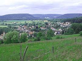 A general view of Rang | |
 Coat of arms | |
Location of Rang 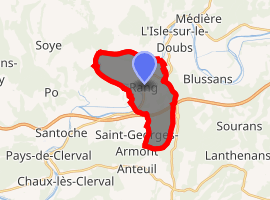
| |
 Rang  Rang | |
| Coordinates: 47°25′38″N 6°33′48″E | |
| Country | France |
| Region | Bourgogne-Franche-Comté |
| Department | Doubs |
| Arrondissement | Montbéliard |
| Canton | Bavans |
| Intercommunality | Isles du Doubs |
| Government | |
| • Mayor (2008–2014) | Guy Girardot |
| Area 1 | 10.32 km2 (3.98 sq mi) |
| Population (2017-01-01)[1] | 418 |
| • Density | 41/km2 (100/sq mi) |
| Time zone | UTC+01:00 (CET) |
| • Summer (DST) | UTC+02:00 (CEST) |
| INSEE/Postal code | 25479 /25250 |
| Elevation | 280–524 m (919–1,719 ft) |
| 1 French Land Register data, which excludes lakes, ponds, glaciers > 1 km2 (0.386 sq mi or 247 acres) and river estuaries. | |
Geography
Rang lies 4 km (2.5 mi) from L'Isle-sur-le-Doubs in a promontory formed by the meandering of the Doubs River. It also lies on the Rhône-Rhine Canal.
Population
| Historical population | ||
|---|---|---|
| Year | Pop. | ±% |
| 1962 | 364 | — |
| 1968 | 405 | +11.3% |
| 1975 | 469 | +15.8% |
| 1982 | 518 | +10.4% |
| 1990 | 474 | −8.5% |
| 1999 | 450 | −5.1% |
| 2008 | 404 | −10.2% |
| 2012 | 438 | +8.4% |
See also
External links
| Wikimedia Commons has media related to Rang (Doubs). |
- Rang on the intercommunal Web site of the region (in French)
| Authority control |
|
|---|
This article is issued from Wikipedia. The text is licensed under Creative Commons - Attribution - Sharealike. Additional terms may apply for the media files.