Le Luhier
Le Luhier is a commune in the Doubs department in the Bourgogne-Franche-Comté region in eastern France.
Le Luhier | |
|---|---|
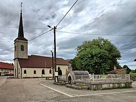 The fountain and church in Le Luhier | |
Location of Le Luhier 
| |
 Le Luhier  Le Luhier | |
| Coordinates: 47°10′09″N 6°39′36″E | |
| Country | France |
| Region | Bourgogne-Franche-Comté |
| Department | Doubs |
| Arrondissement | Pontarlier |
| Canton | Morteau |
| Intercommunality | Plateau du Russey |
| Government | |
| • Mayor (2008–2014) | Eric Humbert |
| Area 1 | 5.21 km2 (2.01 sq mi) |
| Population (2017-01-01)[1] | 222 |
| • Density | 43/km2 (110/sq mi) |
| Time zone | UTC+01:00 (CET) |
| • Summer (DST) | UTC+02:00 (CEST) |
| INSEE/Postal code | 25351 /25210 |
| Elevation | 790–1,050 m (2,590–3,440 ft) |
| 1 French Land Register data, which excludes lakes, ponds, glaciers > 1 km2 (0.386 sq mi or 247 acres) and river estuaries. | |
Geography
The commune is located 9 km (5.6 mi) east of Le Russey on the road from Maîche to Besançon.
Population
| Historical population | ||
|---|---|---|
| Year | Pop. | ±% |
| 1962 | 133 | — |
| 1968 | 162 | +21.8% |
| 1975 | 137 | −15.4% |
| 1982 | 148 | +8.0% |
| 1990 | 160 | +8.1% |
| 1999 | 146 | −8.8% |
| 2008 | 187 | +28.1% |
| 2012 | 199 | +6.4% |
See also
External links
| Wikimedia Commons has media related to Le Luhier. |
| Authority control |
|
|---|
This article is issued from Wikipedia. The text is licensed under Creative Commons - Attribution - Sharealike. Additional terms may apply for the media files.