Chiefland, Florida
Chiefland is a city in Levy County, Florida, United States. The population was 2,245 at the 2010 census.[5] Chiefland calls itself the "Gem of the Suwannee Valley" and was incorporated in 1929.
Chiefland, Florida | |
|---|---|
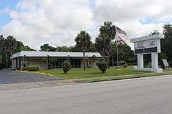 Chiefland City Hall | |
| Motto(s): "Gem of The Suwanee Valley" | |
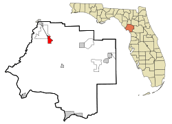 Location in Levy County and the state of Florida | |
 Chiefland, Florida Location in the United States | |
| Coordinates: 29°28′54″N 82°51′44″W | |
| Country | |
| State | |
| County | Levy |
| Government | |
| • Mayor | Betty |
| Area | |
| • Total | 6.74 sq mi (17.45 km2) |
| • Land | 6.74 sq mi (17.45 km2) |
| • Water | 0.00 sq mi (0.00 km2) |
| Elevation | 33 ft (10 m) |
| Population (2010) | |
| • Total | 2,245 |
| • Estimate (2018)[2] | 2,169 |
| • Density | 321.95/sq mi (124.31/km2) |
| Time zone | UTC-5 (Eastern (EST)) |
| • Summer (DST) | UTC-4 (EDT) |
| ZIP codes | 32626, 32644 |
| Area code(s) | 352 |
| FIPS code | 12-11925[3] |
| GNIS feature ID | 0307630[4] |
| Website | chiefland |
History
A village of the Timucua people was once located south of the present city and at Manatee Springs. The area's economy is traditionally based on agriculture, primarily farming (peanuts, watermelons, hay); ranching (cattle, hogs); dairy (milk); timber (pulpwood, lumber, turpentine) and aquaculture (fishing, oystering, crabbing).
Attractions
Manatee Springs State Park is located 6 miles (10 km) west of town; the crystal-clear water is a "first-magnitude" spring that flows directly into the Suwannee River. The park offers a full slate of activities, including camping. Manatees can be seen in the spring year-round, but especially in late fall and winter, where the constant 72 °F (22 °C) temperature of the spring is much warmer than river water.
Commerce
Chiefland is located in the northwest corner of the county, where Levy, Dixie and Gilchrist counties adjoin (known as the "Tri-County area"). As growth in north Florida increased during the last quarter of the twentieth century, Chiefland became a local center for shopping. A 202,000 sq ft (18,800 m2) Walmart Supercenter was opened in 1995, and increased traffic along US 19/98 support a variety of national fast food franchises plus Best Western and Days Inn motels. Georgia-Pacific was a large employer, operating a mill in Chiefland from 1955 to 1978. Agriculture is still a major factor in the local economy, but there has been a big shift to a service economy. There are three incarceration facilities in the area: Cross City Correctional Institution & Work Camp; Lancaster Correctional Institution & Work Camp; and Levy Forestry Camp. They provide a total of over 800 jobs.[6]
Demographics
| Historical population | |||
|---|---|---|---|
| Census | Pop. | %± | |
| 1930 | 421 | — | |
| 1940 | 572 | 35.9% | |
| 1950 | 843 | 47.4% | |
| 1960 | 1,459 | 73.1% | |
| 1970 | 1,965 | 34.7% | |
| 1980 | 1,986 | 1.1% | |
| 1990 | 1,917 | −3.5% | |
| 2000 | 1,993 | 4.0% | |
| 2010 | 2,245 | 12.6% | |
| Est. 2018 | 2,169 | [2] | −3.4% |
| U.S. Decennial Census[7] | |||
As of the census[3] of 2000, there were 1,993 people, 796 households, and 511 families residing in the city. The population density was 509.5 inhabitants per square mile (196.8/km2). There were 931 housing units at an average density of 238.0 per square mile (91.9/km2). The racial makeup of the city was 60.36% White, 34.27% African American, 0.65% Native American, 1.66% Asian, 0.10% Pacific Islander, 0.65% from other races, and 2.31% from two or more races. Hispanic or Latino of any race were 2.76% of the population.
There were 796 households, out of which 35.7% had children under the age of 18 living with them, 36.1% were married couples living together, 23.4% had a female householder with no husband present, and 35.8% were non-families. 32.2% of all households were made up of individuals, and 15.5% had someone living alone who was 65 years of age or older. The average household size was 2.45 and the average family size was 3.05.
In the city, the population was spread out, with 31.3% under the age of 18, 9.0% from 18 to 24, 22.8% from 25 to 44, 20.0% from 45 to 64, and 16.9% who were 65 years of age or older. The median age was 34 years. For every 100 females, there were 79.7 males. For every 100 females age 18 and over, there were 71.3 males.
The median income for a household in the city was $17,331, and the median income for a family was $23,750. Males had a median income of $25,000 versus $19,792 for females. The per capita income for the city was $10,676. About 33.3% of families and 36.8% of the population were below the poverty line, including 46.0% of those under age 18 and 24.4% of those aged 65 or over.
Education
Chiefland has two public schools: Chiefland Middle High School, and Chiefland Elementary. The School Board of Levy County controls their operation and also supervises two charter schools: Nature Coast Middle School and Whispering Winds. Other schools under the board's jurisdiction are in the town of Bronson, the city of Williston, the city of Cedar Key, and Yankeetown.
The College of Central Florida has plans for a $12 million permanent facility on 35 acres (14 ha) of donated land by the Mann family. The location is 5 miles (8 km) north of the city. The college currently operates the Levy Center in downtown Chiefland. The new location has been designated the Jack Wilkinson Levy Campus in honor of the former high school math teacher's donation of $2.5 million to the campus.
Library
Levy County provides Chiefland with a local public library. The Luther Callaway Public Library is a depository library that receives publications from the State of Florida for public use.[8] Luther Callaway was a postmaster and school teacher.[9]
Geography
Chiefland is located at 29°28′54″N 82°51′44″W (29.481801, -82.862097).[10]
According to the United States Census Bureau, the city has a total area of 16.1 square miles (42 km2), all land.[5]
Chiefland is at the junction of U.S. Highways Alternate 27, 19, and 98. US 129 was converted into a separate junction in the early 21st century. It is 30 miles (48 km) southwest of Gainesville.
Healthcare
The State of Florida has approved a 28-bed hospital in Chiefland to serve the needs of western Levy County, Dixie County, and Gilchrist County. The Suwannee Valley Community Hospital is expected to cost $27 million, and Ameris Health Systems is leading the effort. The first drawing of the facility was rendered in March 2008.
See also
References
- "2018 U.S. Gazetteer Files". United States Census Bureau. Retrieved Jul 19, 2019.
- "Population and Housing Unit Estimates". Retrieved June 4, 2019.
- "U.S. Census website". United States Census Bureau. Retrieved 2008-01-31.
- "US Board on Geographic Names". United States Geological Survey. 2007-10-25. Retrieved 2008-01-31.
- "Geographic Identifiers: 2010 Demographic Profile Data (G001): Chiefland city, Florida". U.S. Census Bureau, American Factfinder. Archived from the original on February 12, 2020. Retrieved December 4, 2012.
- Florida Department of Corrections website: Region II & III facilities Archived June 13, 2008, at the Wayback Machine
- "Census of Population and Housing". Census.gov. Retrieved June 4, 2015.
- "Florida Department of State". Division of Library and Information Services. Retrieved 22 April 2016.
- Carolyn Cohens Levy County, Arcadia Publishing, 2009.
- "US Gazetteer files: 2010, 2000, and 1990". United States Census Bureau. 2011-02-12. Retrieved 2011-04-23.
External links
- Greater Chiefland Chamber of Commerce
- Chiefland.com
- Chiefland.net
- School Board of Levy County
- Chiefland High School
- Chiefland Middle School
- Chiefland Elementary School
Municipalities and communities of Levy County, Florida, United States | ||
|---|---|---|
| Cities |  | |
| Towns | ||
| CDPs | ||
| Unincorporated communities | ||
| Footnotes | ‡This populated place also has portions in an adjacent county or counties | |
| Wikimedia Commons has media related to Chiefland, Florida. |
| Authority control |
|
|---|