Lake Junaluska, North Carolina
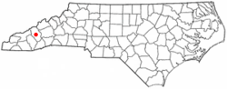
Lake Junaluska is a census-designated place (CDP) in Haywood County, North Carolina, United States, in the Blue Ridge Mountains. It is part of the Asheville Metropolitan Statistical Area. Lake Junaluska is named after nearby Mount Junaluska (now North Eaglenest Mountain), which in turn was named after Chief Junaluska, a Cherokee leader. As of the 2010 census the population of the community was 2,734.[3]
Lake Junaluska, North Carolina | |
|---|---|
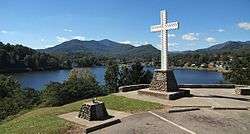 A Christian cross stands above the community. | |
 Location of Lake Junaluska, North Carolina | |
| Coordinates: 35°31′40″N 82°57′34″W[1] | |
| Country | United States |
| State | North Carolina |
| County | Haywood |
| Area | |
| • Total | 5.6 sq mi (14.6 km2) |
| • Land | 5.3 sq mi (13.8 km2) |
| • Water | 0.3 sq mi (0.8 km2) |
| Elevation | 2,552 ft (778 m) |
| Population (2010) | |
| • Total | 2,734 |
| • Density | 513/sq mi (197.9/km2) |
| Time zone | UTC-5 (Eastern (EST)) |
| • Summer (DST) | UTC-4 (EDT) |
| ZIP code | 28745 |
| Area code(s) | 828 |
| FIPS code | 37-36480[2] |
| GNIS feature ID | 1021078[1] |
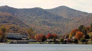
The 200-acre (81 ha) manmade lake is surrounded by private residences and the Lake Junaluska Conference and Retreat Center. The lake is fed primarily from Richland Creek and discharges into the creek, maintaining an approximately constant lake level. Richland Creek is a tributary to the Pigeon River. Recreation on the lake includes canoes, kayaks, fishing and swimming. Only electric trolling motors are permitted on the lake to maintain a quiet environment. There is a 3.5-mile (5.6 km) paved walking trail around the lake. The Blue Ridge Parkway is nearby as well as Great Smoky Mountains National Park.
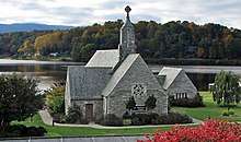
Lake Junaluska is the site of the headquarters of the World Methodist Council (WMC), a consultative body linking almost all Methodist denominations worldwide. The headquarters is itself located on the campus of the Lake Junaluska Conference and Retreat Center which is used for United Methodist annual conferences and other religious conventions and events.
History
On June 25, 1913, the Second General Missionary Conference of the Methodist Episcopal Church, South convened in the new auditorium, beside a lake yet to be filled, created by damming Richland Creek. There were only 13 homes, and no hotel until 1914, so 4,000 people had to stay elsewhere. The Junaluska Inn was built in 1917 but had caught fire and burned down the next year. A new hotel in 1921 went up on the same site, eventually to be named for Bishop Walter Russell Lambuth; additions were made in 1956 and 1964. In 1923, a classroom building called Shackford Hall went up on the lake's west end. Both Lambuth Inn and Shackford Hall have been named to the National Register of Historic Places.[4][5]
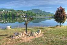
In 1922, a large, lighted cross was built at a spot overlooking the lake near Lambuth Inn, the oldest hotel at the lake. In 1994, a new cross was installed and the original, eventually restored, was moved to Mount Shepherd Retreat Center near Asheboro, North Carolina.[6]
The Southeastern Jurisdiction (SEJ) of the United Methodist Church became the owner in 1948.[4] In the 1950s, the World Methodist Council moved its headquarters to Lake Junaluska.[4]
Conference and Retreat Center

The Lake Junaluska Conference and Retreat Center hosts events for the United Methodist Church, Seventh-day Adventist Church, The Salvation Army, Church of the Brethren, and other organizations. Several musical events are hosted in Stuart Auditorium, including Folkmoot USA programs and Appalachian bluegrass concerts, including the Smoky Mountain Folk Festival. The facilities are intended to be used for the renewal of "body, mind and spirit". The Terrace Hotel and the Lambuth Inn, the community's primary accommodations, were extensively renovated in 2015 and 2018.[7] The Corneille Bryan Native Garden is one of many subtle features of the campus, containing many plants once abundant but now rare.[8]
The Conference and Retreat Center is governed by an active, diverse (gender, age, and ethnicity) 32-member Board of Trustees, currently 68% of the Board members are property owners in the Lake Junaluska community. The board provides strategic direction, and budget approval for the Conference and Retreat Center, the Lake Junaluska Public Works, residential fees, and utility (water and sewer) rates. The Executive Director, who has day-to-day management responsibility, reports to the board of Trustees. The board approves changes to the rules and regulations of the community.[9] The amenities of Lake Junaluska include lodging, meeting facilities, dining (food service), trails, gardens, meditation areas, golf, and other recreation opportunities. The maintenance of the public areas around the lake and the dam, which is inspected annually, are funded primarily through charitable giving and proceeds from lodging guests. This includes the periodic removal of sediment that has been carried into the lake from Richland Creek. All property within the boundaries of the Assembly, approximately 5.8 square miles (15 km2), has deed covenant restrictions that give the Board of Trustees the right to enforce regulations and the first right of refusal on all property sales.[10]
Geography
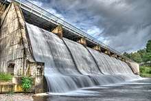
Lake Junaluska is located in central Haywood County just east of the artificial lake of the same name. The lake was formed by damming Richland Creek (a tributary to the Pigeon River) which flows past northwest of the community.[11] Haywood County has 18 mountain peaks over 6,000 feet (1,800 m), more than any other county east of the Mississippi River. The closest high summits are 4,228-foot (1,289 m) High Top on Utah Mountain, 2 miles (3 km) to the north, and 5,071-foot (1,546 m) North Eaglenest Mountain (formerly Mount Junaluska), 4 miles (6 km) to the southwest.
The community is bordered by Waynesville, the Haywood county seat, to the south, Maggie Valley to the west, and Clyde to the east. U.S. Routes 19, 23, 74, and 276 all pass through the community. Interstate 40 passes just northeast of the community, with access from Exits 24 and 27. Asheville is 27 miles (43 km) to the east via I-40 or by Routes 19, 23, and 74. Route 19 leads west 25 miles (40 km) to Cherokee near the south entrance to Great Smoky Mountains National Park. Routes 23 and 74, the Great Smoky Mountains Expressway, leads southwest 22 miles (35 km) to Sylva, and US 276 leads southeast through Waynesville and 41 miles (66 km) to Brevard.
According to the U.S. Census Bureau, the Lake Junaluska CDP has a total area of 5.6 square miles (14.6 km2), of which 5.3 square miles (13.8 km2) are land and 0.3 square miles (0.8 km2), or 5.53%, are water.[3]
Climate
Lake Junaluska has an oceanic climate under the Köppen climate classification (Köppen Cfb). Monthly temperature averages range from 37.2 °F (2.9 °C) in January to 70.9 °F (21.6 °C) in July. Precipitation averages 46.1 inches (1,170 mm) annually, and snowfall averages 13.8 inches (350 mm).[12]
| Climate data for Lake Junaluska, North Carolina | |||||||||||||
|---|---|---|---|---|---|---|---|---|---|---|---|---|---|
| Month | Jan | Feb | Mar | Apr | May | Jun | Jul | Aug | Sep | Oct | Nov | Dec | Year |
| Record high °F (°C) | 78 (26) |
79 (26) |
89 (32) |
89 (32) |
92 (33) |
98 (37) |
98 (37) |
96 (36) |
92 (33) |
90 (32) |
83 (28) |
78 (26) |
98 (37) |
| Average high °F (°C) | 49.0 (9.4) |
52.3 (11.3) |
59.5 (15.3) |
67.7 (19.8) |
74.9 (23.8) |
80.9 (27.2) |
83.4 (28.6) |
82.7 (28.2) |
77.0 (25.0) |
69.0 (20.6) |
60.1 (15.6) |
51.1 (10.6) |
67.3 (19.6) |
| Average low °F (°C) | 23.3 (−4.8) |
26.1 (−3.3) |
32.0 (0.0) |
38.9 (3.8) |
47.2 (8.4) |
55.3 (12.9) |
59.1 (15.1) |
58.6 (14.8) |
51.6 (10.9) |
40.4 (4.7) |
31.7 (−0.2) |
25.5 (−3.6) |
40.8 (4.9) |
| Record low °F (°C) | −22 (−30) |
−16 (−27) |
−8 (−22) |
15 (−9) |
24 (−4) |
31 (−1) |
40 (4) |
38 (3) |
27 (−3) |
12 (−11) |
0 (−18) |
−8 (−22) |
−22 (−30) |
| Average precipitation inches (mm) | 4.33 (110) |
4.48 (114) |
4.39 (112) |
3.76 (96) |
4.30 (109) |
4.07 (103) |
3.71 (94) |
4.20 (107) |
3.94 (100) |
2.65 (67) |
3.73 (95) |
4.04 (103) |
47.61 (1,209) |
| Average snowfall inches (cm) | 4.7 (12) |
3.0 (7.6) |
2.5 (6.4) |
1.2 (3.0) |
0.2 (0.51) |
0 (0) |
0 (0) |
0 (0) |
0 (0) |
0 (0) |
0.4 (1.0) |
2.0 (5.1) |
14.1 (36) |
| Average precipitation days (≥ 0.01 in) | 10.7 | 10.7 | 11.7 | 11.5 | 12.6 | 13.0 | 14.1 | 12.6 | 10.1 | 8.4 | 10.1 | 11.0 | 136.5 |
| Average snowy days (≥ 0.1 in) | 2.1 | 2.1 | 1.2 | 0.3 | 0 | 0 | 0 | 0 | 0 | 0 | 0.4 | 1.4 | 7.6 |
| Source: NOAA (normals 1981−2010)[13] | |||||||||||||
Today
The Lake Junaluska Public Works office manages the roads and utilities. Water for the community is purchased from the town of Waynesville, and sewage treatment is provided by Waynesville through a purchase agreement. Water and sewer fees and annual service fees provide funds for maintenance and improvements to the infrastructure. The community has engaged in a program to renew roads and systematically replace water and sewer lines without incurring debt. A prioritized list of improvements was initially developed,[14] and replacement of the oldest underground water lines has saved money by reducing water loss due to leakage.
A Community Council of elected representatives provides guidance to the public works office and Conference and Retreat Center leadership on issues that impact the community, such as utility rates, annual service charges, residential rules, and regulations.[15][16] Open monthly meetings also provide a means for the property owners to learn about new developments in the community and provide input to the council and the conference and retreat center leadership.
The community of residents, year-round and seasonal alike, are a very diverse active group that enjoy many opportunities for involvement in recreation and fellowship. Community organizations include the Lake Junaluska Assembly Property Owners organization (LJAPOO),[17] which addresses issues associated with the ownership, and the Junaluskans, which is a service group that meets twice monthly and supports many activities.
The campus is also the home to the Foundation for Evangelism,[18] a non-profit organization serving ministries of the United Methodist Church by promoting the growth of new generations of clergy and laity that have a passion for evangelism.
Lake Junaluska is the site of the headquarters of the World Methodist Council (WMC), a consultative body linking almost all Methodist denominations worldwide.
Demographics
As of the census[2] of 2000, there were 2,675 people, 1,262 households, and 861 families residing in the CDP. The population density was 483.6 people per square mile (186.8/km²). There were 1,848 housing units at an average density of 334.1 per square mile (129.0/km²). The racial makeup of the CDP was 98.65% White, 0.37% African American, 0.26% Native American, 0.11% Asian, 0.07% from other races, and 0.52% from two or more races. Hispanic or Latino of any race were 1.35% of the population.
There were 1,262 households out of which 18.1% had children under the age of 18 living with them, 58.3% were married couples living together, 7.8% had a female householder with no husband present, and 31.7% were non-families. 29.5% of all households were made up of individuals and 14.3% had someone living alone who was 65 years of age or older. The average household size was 2.12 and the average family size was 2.57.
In the CDP, the population was spread out with 16.2% under the age of 18, 5.7% from 18 to 24, 20.6% from 25 to 44, 29.4% from 45 to 64, and 28.1% who were 65 years of age or older. The median age was 50 years. For every 100 females, there were 86.7 males. For every 100 females age 18 and over, there were 82.1 males.
The median income for a household in the CDP was $46,932, and the median income for a family was $54,444. Males had a median income of $38,224 versus $29,219 for females. The per capita income for the CDP was $23,031. About 4.2% of families and 8.7% of the population were below the poverty line, including 17.9% of those under age 18 and 3.0% of those age 65 or over.
References
- U.S. Geological Survey Geographic Names Information System: Lake Junaluska, North Carolina
- "U.S. Census website". United States Census Bureau. Retrieved 2008-01-31.
- "Geographic Identifiers: 2010 Census Summary File 1 (G001): Lake Junaluska CDP, North Carolina". American Factfinder. U.S. Census Bureau. Archived from the original on February 13, 2020. Retrieved December 15, 2017.
- Neill Caldwell, "A Brief History of Lake Junaluska," http://www.umc.org/site/c.gjJTJbMUIuE/b.1777795/k.2D19/A_brief_history_of_Lake_Junaluska.htm, Retrieved on 2008/06/17.
- "National Register Information System". National Register of Historic Places. National Park Service. July 9, 2010.
- "Archived copy". Archived from the original on 2008-05-15. Retrieved 2008-06-17.CS1 maint: archived copy as title (link), Retrieved on 2008/06/17.
- Report of the Lake Junaluska Assembly Inc to the Southeastern Jurisdiction of the United Methodist Church 2018
- https://Ourstate%5B%5D magazine www.ourstate.com/corneille-bryan- native-garden/
- Report of the Lake Junaluska Assembly Inc to the Southeastern Jurisdiction of the United Methodist Church 2015
- http://www.lakejunaluska.com/about_us/community/assembly_public_works/
- Clyde, NC, 7.5 Minute Topographic Quadrangle, USGS, 1967 (1979 rev.)
- "NOWData - NOAA Online Weather Data". National Oceanic and Atmospheric Administration. Retrieved December 1, 2012.
- http://www.lakejunaluska.com/i/downloads/CIP_Final.pdf
- http://www.lakejunaluska.com/about_us/community/jacc/
- http://www.lakejunaluska.com/i/downloads/bylaws_PW2016.pdf
- http://www.lakejunaluska.com/about_us/community/ljapoo/
- http://www.foundationforevangelism.org
External links
| Wikimedia Commons has media related to Lake Junaluska, North Carolina. |
Municipalities and communities of Haywood County, North Carolina, United States | ||
|---|---|---|
| Towns |  | |
| CDPs | ||
| Unincorporated communities | ||
| Indian reservation | ||
| Footnotes | ‡This populated place also has portions in an adjacent county or counties | |