U.S. Route 97
U.S. Route 97 (US 97) is a major north–south United States highway in the western United States. It begins at a junction with Interstate 5 at Weed, California, and travels north, ending in Oroville in Okanogan County, Washington, at the Canada–US border, across from Osoyoos, British Columbia, becoming British Columbia Highway 97 upon entering Canada. Major cities that lie on US 97 include Klamath Falls, Bend, and Redmond in Oregon and Yakima, Ellensburg, and Wenatchee in Washington.
| |
|---|---|
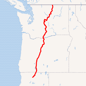
US 97 highlighted in red | |
| Route information | |
| Length | 663 mi (1,067 km) |
| Existed | 1926–present |
| Major junctions | |
| South end | |
| |
| North end | |
| Location | |
| States | California, Oregon, Washington |
| Highway system | |

A portion of the highway in California and Oregon is part of the Volcanic Legacy Scenic Byway.
Route description
California
US 97 begins in the town of Weed, California. From Weed, the highway continues in a northeasterly direction toward Klamath Falls, Oregon. The California portion of US 97 is approximately 55 miles (89 km) in length, with its southern end at the junction with Interstate 5 and California State Route 265 in Weed, and reaching Oregon after the junction with California State Route 161 (Stateline Rd) just north of the community of Dorris, California.
While the town of Weed has an elevation of 3,467 feet (1,057 m), a section of US 97 in California is above 5,000 feet (1,500 m) in elevation with two significant summits. At mile 19 the Grass Lake Summit has an elevation of 5,101 feet (1,555 m). There is a rest area with restrooms at Grass Lake about a half-mile south of the summit.[1] At mile 30 the Mount Hebron Summit has an elevation of 5,202 feet (1,586 m). The small community of Mount Hebron follows the descent from the summit, but is located a couple miles east of the highway. The next community located directly on the highway is unincorporated town of Macdoel.
The entire length of the California portion of US 97 is part of the Volcanic Legacy Scenic Byway.
Southbound travelers entering California must be prepared to stop at the California Department of Food and Agriculture (CDFA) Inspection Station south of Dorris. After a five-year hiatus, during which only commercial vehicles were stopped, all motorists are once again subject to inspection.[2]
Oregon
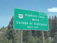
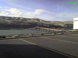
US 97 goes through the city of Klamath Falls before continuing north to Bend and the junction of US 20. From there, US 97 intersects US 26 at Madras before US 197 continues to the northwest, and US 97 continues northeast to I-84 and the Columbia River. The section from Sunriver to just north of Redmond is a divided highway with two lanes in each direction.
Washington
North of the Columbia River, US 97 intersects SR 14 before continuing north. Between Goldendale and Yakima the highway passes over Satus Pass. In Yakima, US 97 runs concurrently with I-82 north to Ellensburg and then on I-90 west before continuing north into Wenatchee National Forest to US 2. Both routes continue east into Wenatchee and then north along the eastern bank of the Columbia River, before US 2 continues east and US 97 continues north. US 97 Alternate continues along the western bank of the river, before US 97 shifts to the western side of the river. US 97 intersects SR 20 near Omak before US 97 crosses the Canada–US border north of Oroville, Washington and becomes British Columbia Highway 97 at Osoyoos, BC. BC Highway 97 is the longest uninterrupted highway in the province winding south-to-north, eventually becoming part of the Alaska Highway and passing into the Yukon territory. However, the '97' designation ends at the BC/Yukon border.
Alaska
The Alaska Highway portion of Alaska Route 2 was once proposed to be part of US 97. This never came to pass, as the Yukon territory declined to also renumber its portion of the highway to '97'.[3] The Alaska International Rail and Highway Commission lobbied for the designation of US 97 from Fairbanks, Alaska to Mexico City in the late 1950s.[4]
Major intersections
- California

- Oregon


- Washington


See also

- U.S. Route 197
References
- California Dept. of Transportation "Caltrans Rest Areas: Grass Lake - Siskiyou County" http://www.dot.ca.gov/hq/maint/ra/ra52.htm
- O'Neill, Janet. "Inspection station re-open after five-year hiatus" Record Searchlight. 17 Nov. 08 http://www.redding.com/news/2008/nov/17/inspection-stations-re-open-after-five-year/
- "History". Highway 97 in British Columbia, Washington, Oregon, & California. Summit Solutions Ltd. 2011. Retrieved September 17, 2018.
- "Alaskan At Highway 97 Meeting". The Seattle Times. November 15, 1959. p. 73.
External links
| Wikimedia Commons has media related to U.S. Route 97. |
Routes in italics are no longer a part of the system. Highlighted routes are considered main routes of the system. |