Thomaston, Georgia
Thomaston is a city in and the county seat of Upson County,[6] Georgia, United States.[7] The population was 9,170 at the 2010 census. It is the principal city of and is included in the Thomaston, Georgia Micropolitan Statistical Area, which is included in the Atlanta - Sandy Springs (GA) - Gainesville (GA) - Alabama (partial) Combined Statistical Area.
City of Thomaston | |
|---|---|
 Thomaston-Upson County Government Administration Complex | |
| Motto(s): "One of the Best 100 Towns"[1] | |
 Location in Upson County and the state of Georgia. | |
| Coordinates: 32°54′N 84°20′W | |
| Country | United States |
| State | Georgia |
| County | Upson |
| Area | |
| • Total | 9.74 sq mi (25.22 km2) |
| • Land | 9.53 sq mi (24.69 km2) |
| • Water | 0.20 sq mi (0.53 km2) |
| Elevation | 784 ft (239 m) |
| Population (2010) | |
| • Total | 9,170 |
| • Estimate (2018)[3] | 8,740 |
| • Density | 916.82/sq mi (354.00/km2) |
| Time zone | UTC-5 (Eastern (EST)) |
| • Summer (DST) | UTC-4 (EDT) |
| ZIP code | 30286 |
| Area code(s) | 706 |
| FIPS code | 13-76168[4] |
| GNIS feature ID | 0324093[5] |
| Website | Official City of Thomaston, Georgia Government Website |
Thomaston is located on US Route 19 and State Route 3, which run north and south, and on State Routes 36 and 74, which run (more or less) east and west.
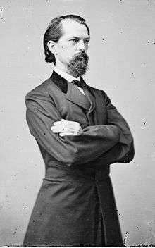
History
.JPG)
Thomaston was incorporated on January 1, 1825,[8] and designated as the seat of Upson County. The town was named for General Jett Thomas, an Indian fighter in the War of 1812.[9]
Demographics
| Historical population | |||
|---|---|---|---|
| Census | Pop. | %± | |
| 1880 | 570 | — | |
| 1890 | 1,181 | 107.2% | |
| 1900 | 1,714 | 45.1% | |
| 1910 | 1,645 | −4.0% | |
| 1920 | 2,502 | 52.1% | |
| 1930 | 4,922 | 96.7% | |
| 1940 | 6,396 | 29.9% | |
| 1950 | 6,580 | 2.9% | |
| 1960 | 9,336 | 41.9% | |
| 1970 | 10,024 | 7.4% | |
| 1980 | 9,682 | −3.4% | |
| 1990 | 9,127 | −5.7% | |
| 2000 | 9,411 | 3.1% | |
| 2010 | 9,170 | −2.6% | |
| Est. 2018 | 8,740 | [3] | −4.7% |
| U.S. Decennial Census[10] | |||
As of the census[4] of 2000, there were 9,411 people, 3,862 households, and 2,386 families residing in the city. The population density was 1,039.4 people per square mile (401.5/km2). There were 4,152 housing units at an average density of 458.6 per square mile (177.1/km2). The racial makeup of the city was 62.75% White, 35.30% African American, 0.28% Native American, 0.61% Asian, 0.01% Pacific Islander, 0.53% from other races, and 0.53% from two or more races. Hispanic or Latino of any race were 1.77% of the population.
There were 3,862 households, out of which 28.2% had children under the age of 18 living with them, 37.0% were married couples living together, 21.4% had a female householder with no husband present, and 38.2% were non-families. 35.2% of all households were made up of individuals, and 17.8% had someone living alone who was 65 years of age or older. The average household size was 2.33 and the average family size was 3.00.
In the city, the population was spread out, with 25.3% under the age of 18, 8.4% from 18 to 24, 25.9% from 25 to 44, 19.8% from 45 to 64, and 20.6% who were 65 years of age or older. The median age was 38 years. For every 100 females, there were 77.4 males. For every 100 females age 18 and over, there were 71.3 males.
The median income for a household in the city was $24,695, and the median income for a family was $33,093. Males had a median income of $31,168 versus $20,420 for females. The per capita income for the city was $18,193. About 18.4% of families and 22.5% of the population were below the poverty line, including 37.3% of those under age 18 and 13.9% of those age 65 or over.
Health Care
Its principal hospital is the Upson Regional Medical Center at 801 West Gordon Street.
Industry
Industry in the city is driven primarily by manufacturing which makes up 36.5%. The second largest industry is educational, health, and social service comprising 21.0%. The third largest industry is retail trade at 11.6% of the total industry in Thomaston. The remaining portions of industry include agriculture, construction,wholesale trade, transportation, information, finance, management, administration, arts and entertainment, food service, recreation, accommodation, and public administration.
Arts and culture

National Register of Historic Places
The Upson County courthouse was built in 1908, and is listed on the National Register of Historic Places.[11]
- Pettigrew-White-Stamps House
Annual events
Thomaston hosts an annual Emancipation Proclamation Celebration each May. It is the nation's oldest and longest running emancipation celebration of its kind.[8]
Parks and recreation
- Sprewell Bluff Park, located on the Flint River
- The Greatest Generation Recreational Park
Education
Thomaston-Upson County School District
The Thomaston-Upson County School District holds pre-school to grade twelve, and consists of two elementary schools, a middle school, and a high school.[12] The district has 279 full-time teachers and over 5,009 students.[13]
- Upson-Lee Elementary School
- Upson-Lee Primary School
- Upson-Lee Middle School
- Upson-Lee High School
- Upson-Lee Pre-k
- Upson-Lee Alternative School
Colleges and universities
Southern Crescent Technical College is located in Thomaston, and is a two-year technical school.[14][15]
Notable people
- Elia Goode Byington (1858–1936), journalist
- Kentavious Caldwell-Pope - shooting guard for the Los Angeles Lakers
- Mike Cavan - football player at Univ. of Ga. and former head coach at SMU
- Wayne Cochran - musician (Wayne Cochran and the C.C. Riders)
- Ivylyn Girardeau - medical missionary in Pakistan
- John Brown Gordon - one of Robert E. Lee's most trusted Confederate generals during the American Civil War; governor of Georgia 1886-1890
- Frank Gordy - founder of The Varsity restaurant chain
- William Guilford (1844–1909) - businessman and state legislator
- Bill Hartman - football running back for the Georgia Bulldogs and Washington Redskins before World War II
- John Holliman - broadcast journalist best known as one of CNN's "Boys of Baghdad" during the first Persian Gulf War
- Marion Montgomery - poet, novelist, educator, and critic; close friend and critic of Flannery O'Connor
- Cedric Smith - African American painter
- Martha Pennyman - Olympic gold medalist
- Coy Bowles - Grammy award-winning country artist Zac Brown Band
- Jerry Walker Jr. - Civil Rights Activist
- Chris Teal - West Georgia University Hall of Fame
References
- "Official City of Thomaston, Georgia Government Website". Official City of Thomaston, Georgia Government Website. Retrieved September 5, 2012.
- "2018 U.S. Gazetteer Files". United States Census Bureau. Retrieved February 12, 2020.
- "Population and Housing Unit Estimates". Retrieved June 4, 2019.
- "U.S. Census website". United States Census Bureau. Retrieved January 31, 2008.
- "US Board on Geographic Names". United States Geological Survey. October 25, 2007. Retrieved January 31, 2008.
- "Find a County". National Association of Counties. Retrieved June 7, 2011.
- "Profile for Thomaston, Georgia, GA". ePodunk. Retrieved September 5, 2012.
- "Thomaston". Georgia Gov. Retrieved September 5, 2012.
- Krakow, Kenneth K. (1975). Georgia Place-Names: Their History and Origins (PDF). Macon, GA: Winship Press. p. 225. ISBN 0-915430-00-2.
- "Census of Population and Housing". Census.gov. Retrieved June 4, 2015.
- "Thomaston". Georgia Department of Community Affairs. Retrieved September 5, 2012.
- Georgia Board of Education, Retrieved June 27, 2010.
- School Stats, Retrieved June 27, 2010.
- "Thomaston". Georgia Department of Community Affairs. Retrieved September 5, 2012.
- "Flint River Campus". Southern Crescent Technical College. Archived from the original on October 5, 2012. Retrieved September 5, 2012.
External links
| Wikimedia Commons has media related to Thomaston, Georgia. |
- Official City of Thomaston, Georgia Government Website Portal style website, Government, Business, Library, Recreation and more
- City-Data.com Comprehensive Statistical Data and more about Thomaston
- Thomaston-Upson County School District
Municipalities and communities of Upson County, Georgia, United States | ||
|---|---|---|
| City |  Map of Georgia highlighting Upson County | |
| Town | ||
| CDPs | ||
| Unincorporated communities | ||
| Authority control |
|
|---|