Interstate 75 in Tennessee
Interstate 75 (I-75) in the U.S. state of Tennessee runs from Chattanooga to Jellico by way of Knoxville. I-75 enters the East Tennessee region following the Tennessee Valley from Georgia, all the way through Knoxville to near Rocky Top, then climbs into the Cumberland Mountains before crossing over into Kentucky at Jellico.
| ||||
|---|---|---|---|---|

I-75 highlighted in red | ||||
| Route information | ||||
| Maintained by TDOT | ||||
| Length | 161.86 mi[1] (260.49 km) | |||
| Existed | 1958–present | |||
| Major junctions | ||||
| South end | ||||
| North end | ||||
| Location | ||||
| Counties | Hamilton, Bradley, McMinn, Monroe, Loudon, Knox, Anderson, Campbell | |||
| Highway system | ||||
| ||||
Of the six states that I-75 traverses, the segment in Tennessee is the shortest, at 161.86 miles (260.49 km). Between Chattanooga and Knoxville, I-75 follows the route of U.S. Route 11 (US 11), and from Knoxville into Kentucky it follows the route of US 25W. Beginning in Chattanooga, I-75 follows the route of US 41 for the rest of the length to its southern terminus in Miami.
Route description
Chattanooga

Interstate 75 enters Tennessee on the eastern side of East Ridge, a southern suburb of Chattanooga. Less than 1⁄2 mile (0.80 km) mile into Tennessee is an interchange with U.S. Route 41 (US 41/Unsigned US 76). About a mile later, at exit 2, is a three way interchange with the eastern terminus of Interstate 24, which runs west into Downtown Chattanooga and to Nashville. At this interchange, I-75 turns northeast, running along the eastern boundary of Chattanooga. Almost two miles later is an interchange with State Route 320 (SR 320), which connects to East Brainerd, and about a half mile later is a three way interchange with the southern terminus of SR 153, a controlled access highway that runs northwest to the Chattanooga Metropolitan Airport and crosses the Tennessee River on the Chickamauga Dam. Accessible from the northbound lanes at this interchange is Hamilton Place Boulevard, a connector to Hamilton Place Mall. The southbound lanes of I-75 are also accessible from an entrance ramp from this road. At this point, I-75 enters a large commercial area dominated by Hamilton Place, and has an interchange with Shallowford Road about a mile later. A few miles later, at exit 7, I-75 has an interchange with US 11 southbound, US 64 westbound and SR 317 westbound, and begins a concurrency with these respective routes. Turning slightly northeast, the interstate crosses a Norfolk Southern Railway and at exit 9, SR 317 splits off to the east. I-75 then crosses a steep ridge, passing between the Enterprise South Industrial Park to the west and Collegedale to the east. A few miles later, in Ooltewah, US 11/64 split off at exit 11, where the route narrows to six lanes. I-75 then turns northwest, and narrows to four lanes.
Bradley to Loudon counties
A few miles later, I-75 begins a steep ascent up the western slope of White Oak Mountain, where the northbound lanes receive a truck climbing lane. At this point, the interstate turns northeast, and for the next three miles traverses east northeast over the top of White Oak Mountain, where it crosses into Bradley County. I-75 then runs for the next several miles through a predominantly wooded and agricultural area and crossing a few ridges before reaching Cleveland at an interchange with APD-40 eastbound (US 64 Bypass), a bypass and connector to US 64. Running along the western edge of Cleveland, I-75 has an interchange with SR 60 about 4.5 miles later, also crossing Candies Creek Ridge at this location, and less than 2 miles later, an interchange with Paul Huff Parkway, a major thoroughfare along the northern part of Cleveland. The interstate then leaves Cleveland, and enters rural northern Bradley County, running northeast. Beginning at this point and continuing for nearly 60 miles, I-75 is very straight and flat, with few curves. Nearly the entirety of this section also contains an extremely wide median, mostly separated by trees. In some locations, the north and southbound lanes are as much as a half mile apart.
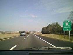
About twelve miles north of the central business district of Cleveland, I-75 curves to the northeast, and crosses the Hiwassee River into McMinn County, and then curves back to the northwest. This area is extremely susceptible to fog hazards, which obscures the visibility of drivers, and several bad accidents have occurred on this section as a result. Running through mostly wooded and agricultural areas, I-75 reaches Athens about 15 miles later, and has an interchange with SR 30, a major east-west corridor in East Tennessee. Running through northern McMinn County, the interstate passes near several unincorporated communities, and has interchanges with several secondary state highways. Around mile marker 58, I-75 enters Monroe County, and a few miles later passes near the town of Sweetwater, containing an interchange with SR 68, another major primary state highway. A few miles later, I-75 crosses into Loudon County. At exit 72 is an interchange with SR 72, which connects to Loudon, and a few miles later, the highway crosses the Tennessee River on the Mitchell W. Stout Memorial Bridges. I-75 then enters a predominantly commercial and residential area, and has an interchange with US 321 and SR 95 in Lenoir City. These routes also connect to Oak Ridge and Maryville. Curving slightly to the west and then again to the east, I-75 reaches an interchange with I-40 westbound about three miles later, where it begins a concurrency with I-40. About 20 miles west southwest of Knoxville, the concurrent routes widen to six lanes and cross into Knox County less than a mile later.
Knoxville
Running approximately east northeast the two interstates pass through the western suburbs of Knoxville including Farragut and West Knoxville. Along this concurrency exits are numbered according to I-40 mileage. At exit 374 is an interchange with SR 131 (Lovell Road), where the highway widens to eight lanes, and less than two miles later is a four way interchange with the Pellissippi Parkway (SR 162 westbound, I-140 eastbound), which connects to Oak Ridge to the west and Maryville to the east. At exit 380 is an interchange with US 11/70 (Kingston Pike), which connects to the West Hills neighborhood and West Town Mall. This section is the most heavily traveled section of highway in Tennessee, with an annual average daily traffic (AADT) volume of more than 210,000 vehicles. About 5 miles (8.0 km) later, at an interchange with the western terminus of I-640, the northern bypass around downtown Knoxville, I-75 splits north off of I-40 and onto a concurrency with I-640. Along this concurrency, exits are numbered according to I-640 mileage. Heading north, the interstates come to an interchange with SR 62 (Western Avenue) about a mile later. About 1.5 miles later is a complicated interchange with I-275 southbound, the former route of I-75, and US 25W, where I-75 splits off.[2]
Clinch River Valley and Cumberland Mountains
Leaving Knoxville, I-75 turns north, crossing several paralleling ridges of the Ridge and Valley Appalachians. The terrain for the next 20 miles (32 km) of I-75 north of Knoxville are mostly flat. At exit 112 in Powell, I-75 once again has an interchange with SR 131, and the Interstate narrows from six to four lanes. Entering a rural area, I-75 runs along a creek valley for the next several miles that bisects several ridges in a crooked and hazardous segment marked by several S-curves. Maintaining its north-northwesterly direction, I-75 crosses into Anderson County. Beyond this section, the Cumberland Mountains become visible in the distance. At exit 122 the Interstate has an interchange with SR 61 near Clinton. I-75 then descends sharply into a valley, crossing the Clinch River a few miles later. About four miles (6.4 km) later, near the community of Rocky Top, I-75 has interchanges with US 441, and US 25W, running concurrently with the latter. The Interstate then crosses into Campbell County.

For approximately the last 30 miles (48 km) in Tennessee, I-75 traverses the Cumberland Mountains. This entire section is considered very scenic and is prone to rockslides in many locations. Around milepost 130, I-75 begins its first major ascent for a few miles before leveling out on one of the plateaus of Cumberland Mountains, and at exit 134, near the community of Caryville, US 25W splits off and I-75 begins a concurrency with SR 63. The Interstate then begins another ascent, adding a truck climbing lane going northbound. About six miles (9.7 km) later, the highway levels out on another one of the plateaus and the truck lane terminates. Less than a mile later, SR 63 splits off near the unincorporated community of Pioneer. Traveling through a further sparsely populated rural area marked by dense woodlands, I-75 remains relatively flat for the next few miles before beginning another ascent up the Cumberland Mountains, once again adding a truck climbing lane. Jellico Mountain is a sub-mountain range of the Cumberland Mountains that the interstate traverses near Jellico. I-75 curves sharply to the northeast and about a mile later, it reaches the crests of Jellico Mountain where the truck lane ends. The interstate then climbs the crests of Jellico Mountain for about another four miles (6.4 km) before levelling out on top of Jellico Mountain at an elevation of about 2,000 feet (610 m) and has an interchange with US 25W in the city of Jellico. Less than a mile later, I-75 enters the hilly terrains of eastern Kentucky.
History
Early history
Construction of I-75 in Tennessee began in 1958 with short segments in Chattanooga and Knoxville. The concurrent segment with I-40 between the split near Lenoir City and downtown Knoxville opened to traffic on December 2, 1961.[3] The route was completed through Chattanooga on July 17, 1963, with the completion of the 6.6 miles (10.6 km) segment between the split with I-24 and US 11/64 (Bonny Oaks Drive).[4] I-75 was completed through Knoxville in late 1965.[5] The section between Ooltewah and SR 60 in Cleveland opened on October 18, 1966.[6] Like much of the interstate system in rural Tennessee, priority was generally given to completing rural segments in Middle and West Tennessee over East Tennessee, but the last approximately 35 miles (56 km) segment of I-75 in Tennessee, located mostly in Campbell County, was constructed much earlier than most of the rural segments in Tennessee, reportedly due to the influence of then-Congressman and later U.S. Senator Howard Baker Jr., who was from that area.[7] By 1963, the 1 mile (1.6 km) section between US 25W in Jellico and the Kentucky state line was open to traffic.[8] The 6.8 mile segment between US 25W in Caryville and US 441 in Anderson County was completed in October 1964. Portions of this segment predated the interstate system.
The 25.8 miles (41.5 km) section between US 25W/SR 63 in Caryville and US 25W in Jellico was opened to traffic on October 22, 1968.[9] The section between SR 60 and SR 308 in Bradley County began construction in 1968, but was stalled shortly thereafter.[10] Construction resumed in 1972, and the segment was opened to traffic on January 23, 1973.[11] The section between US 25W north of Knoxville and SR 61 in Clinton broke ground in segments, beginning in August 1968,[12] and was opened to traffic on August 1, 1972.[13] The approximately 6 miles (9.7 km) segment between SR 61 and US 441 in Anderson County was completed in September 1973.[14] The section of the highway between SR 308 near Charleston and SR 30 in Athens opened on December 24, 1973, and was completed the following spring.[15] The last section of I-75 in Tennessee, approximately 32 miles (51 km) between SR 30 in Athens and US 321/SR 95 in Lenoir City, was opened to traffic on December 20, 1974, in a ceremony officiated by then-governor Winfield Dunn.[16] The last section of I-40 and I-81 in Tennessee was opened on this same day.[17]
I-75 originally continued into downtown Knoxville then turned to the north at Malfunction Junction, following what is now signed as I-275. When the western section of I-640 was completed in 1982, I-75 was moved to overlap the auxiliary route to divert through traffic away from downtown in preparation for the 1982 World's Fair. This concurrency is somewhat unusual in that the exit numbers and mile markers follow the auxiliary route I-640 instead of I-75 mileage.
Fog hazards
An approximately five mile section of I-75 in northern Bradley and southern McMinn Counties, including the bridge over the Hiwassee River is prone to hazards from dense fog in the morning, which can severely obscure the visibility of drivers. This segment is located near several heavy industries including the Resolute Forest Products paper mill, formerly Bowater, which operates settling ponds along the interstate. This segment has been the site of several serious multivehicle accidents, the first of which occurred on March 9, 1974, less than three months after the section opened to traffic, and before it had been declared complete.[18] This accident involved 18 vehicles, and killed three and injured 10.[18] A total of six multivehicle accidents occurred along this stretch in the 1970s.[18] The worst, which took place on November 5, 1978, involved 62 vehicles and injured 46, and took place on the Hiwassee River Bridge.[19] After a multivehicle accident on April 15, 1979 which involved 18 vehicles, killed three, and injured 14, TDOT identified the stretch as prone to fog hazards, and agreed to install warning signs with flashing warning lights, which would activate if fog was detected. After this, no serious fog related accidents occurred for more than 11 years.
On December 11, 1990, a 99 vehicle accident occurred in this same area that resulted in 12 deaths and 56 injuries.[20] This accident was considered unusual, due to the density and sudden appearance of the fog, and initial speculation arose about the possibility of the role of water vapor.[21] Extensive investigations followed, and some meteorological experts believe that the fog may have been caused by an unusual phenomenon known as a temperature inversion.[21] Several lawsuits were filed against Bowater, alleging that they had contributed to the fog with their water vapor emissions.[21] A study conducted by researchers at the University of Tennessee in January 1979 had concluded that Bowater's settling ponds were possible contributors to fog in the area.[21] Several lawsuits were also filed against the state of Tennessee, which claimed that TDOT had failed to install adequate warning systems along this stretch of I-75, a position that Bowater also took.[18] The existing fog warning lights were reportedly not working on this day.[22] After settling with the family members of accident victims and survivors in court, TDOT instituted several safety measures along this stretch of highway, including re-striping the roadway with extra markings to make it more visible and installing a computerized fog detection system, which contains a warning system with flashing lights, electronic signs, variable speed limits, and electronic controlled swing gates which block access to the interstate from six entrance ramps in and near this stretch in the event of dense fog.[18] Between mileposts 31 and 39, the highway is designated as a fog advisory zone.[23] A $5.5 million upgrade was completed to this system in 1993, and in 2006, a $6.6 million upgrade was completed which installed video cameras.[18] Bowater also agreed to limit the use of their settling pond closest to the interstate.[18] The accident was profiled in a 1997 episode of the show Forensic Files.[22]
Geological difficulties
The entire section of I-75 in Tennessee north of Knoxville has been subject to many geological difficulties, particularly the last 30 miles through the Cumberland Mountains.
In March 2005, the southbound lanes of Interstate 75 were shut down between mile marker 141 to 143 due to a rockslide below the roadway that caused the pavement to partially collapse.[24]
In March 2012, the southbound lanes of the interstate were again closed to traffic between mile markers 141 and 143 in Campbell County, Tennessee due to a slide beneath the roadway.[25] This was later followed by a second slide in early May 2012[26] that caused a portion of the southbound lanes to completely erode and forced the detour lanes to be closed.
In February 2016, a rock slide closed I-75 near Caryville, Tennessee.[27]
Other incidents
On March 28, 1994, a runaway barge that had broken loose from its mooring due to flooding struck the I-75 bridge over the Tennessee River, along with the US 11 bridge and a railroad bridge. The collision broke loose a chunk of concrete from a post, but engineers determined that it caused no major structural damage. I-75 had been closed to traffic on this section in preparation for the collision.[28]
On April 1, 2019, part of the bridge on I-75 southbound over the ramp from I-24 westbound to I-75 northbound at the split in Chattanooga collapsed, injuring one person and blocking traffic for hours.[29][30][31] The bridge, built in 1959, is one of the oldest on I-75 in Tennessee, and the interchange is the site of frequent accidents. TDOT's chief engineer said that the collapse was most likely caused by weakening of the bridge's rail that occurred when an illegally oversized load hit the bridge.[32]
Improvements
Throughout its history I-75 has seen many reconstruction and widening projects in Tennessee.
The first major reconstruction project was a widening of the concurrent segment of I-75 and I-40 from four to six lanes between the interchange near Lenoir City and Downtown Knoxville, which began in the late 1970s.[33] In the latter 1980s, I-75/I-40 was widened from six to eight lanes between the Pellissippi Parkway and Papermill Road, and multiple interchanges along this segment were reconstructed.[34] These segments have since seen more improvements.
I-75 was widened from four to six and eight lanes in Chattanooga between the interchange with I-24 and SR 153 in the late 1980s. Between 1998 and 2010 a series of projects reconstructed and widened I-75 between SR 153 and north of US 11/64 in Ooltewah. The first of these projects, which began in late 1998 and was completed in 2001, rebuilt the interchange with SR 153, changing the approach of two flyover ramps that connect to I-75 northbound from the left to the right side of the road. This project also modified the interchange with SR 320, removing two cloverleaf loop ramps from I-75 southbound, and moving the access to the entrance ramp from I-75 southbound to a point near the interchange with SR 153. The next project, which widened I-75 further between mileposts 6 and 9 and improved the interchange with SR 317, was completed in November 2005.[35] A new interchange was constructed in 2006 to provide access to the Enterprise South Industrial Park, which at that time was in the process of redevelopment.[36] This interchange, which became exit 9, now provides access to the Volkswagen Chattanooga Assembly Plant, and was not opened until 2010. A segment of SR 317 was later routed onto a concurrency of I-75 between exit 11 and this interchange. Exit 9 was designated as the Bredesen-Ramsey Interchange in 2015 in honor of the efforts of then-governor Phil Bredesen and county mayor Claude Ramsey to bring Volkswagen to Chattanooga.[37] The last of these projects, which began on November 8, 2007, widened I-75 from approximately milepost 10 to milepost 13, just north of the interchange of US 11/64, and included reconstruction of this interchange, including the addition of a loop ramp, and improvements on this road.[38] This project was completed on August 12, 2010, four months ahead of schedule.[39][40]
On May 1, 2008 I-75 northbound traffic was re-routed back along its original path in downtown Knoxville along Interstate 275 as part of SmartFix 40, a major construction project that includes closing a portion of I-40. Traffic was re-routed along I-275 as the ramp from I-640 eastbound/I-75 northbound to I-75 northbound is only one lane which causes traffic delays at peak times.
In December 2018 a contract was awarded to rebuild the interchange with I-24 in Chattanooga.[41] Preliminary work began in May 2019, with completion estimated by June 2021.[42]
Future
In the mid-1990s a freeway, referred to as SR 475 (with the intent of being renamed I-475) was proposed as an outer beltway around Knoxville, running north of the city between I-75/I-40 near Farragut, and I-40 near Sevierville. A number of studies were conducted on the proposed route, but the entire project was cancelled on June 25, 2010.[43]
TDOT has approved the widening of several segments of I-75 in Tennessee from four to six lanes, including the approximately nine-mile (14 km) segment between US 11/US 64 in Ooltewah and APD-40 in Cleveland,[44] the 16-mile (26 km) segment between SR 223 near Philadelphia and the interchange with I-40 near Lenoir City, and the five-mile (8.0 km) segment between SR 131 near Powell and SR 170.[45]
Exit list
Note: the exits north of Knoxville are numbered as if I-75 had taken its original path through downtown Knoxville along I-40 and I-275.
| County | Location | mi | km | Exit | Destinations | Notes |
|---|---|---|---|---|---|---|
| Hamilton | East Ridge | 0.00 | 0.00 | Georgia state line | ||
| 0.32 | 0.51 | 1 | Signed as exits 1A (south) and 1B (north) northbound | |||
| Chattanooga | 1.44 | 2.32 | 2 | South end of US 74 concurrency, left exit northbound; I-24 exits 185A-B; eastern terminus of I-24; directional T interchange. | ||
| 3.51 | 5.65 | 3 | Signed as exits 3A (east) and 3B (west) northbound | |||
| 4.24 | 6.82 | 4A | ||||
| 5.10 | 8.21 | 4B | Hamilton Place Boulevard | Northbound exit and southbound entrance; access to Hamilton Place Mall | ||
| 5.69 | 9.16 | 5 | Shallowford Road | |||
| 6.50 | 10.46 | Standifer Gap Road | Removed c. 1970 | |||
| 7.53 | 12.12 | 7 | South end of US 11/US 64/SR 2 concurrency; signed as exits 7A (SR 317 east) and 7B (SR 317 west) northbound | |||
| 9.05 | 14.56 | 9 | Serves Volkswagen Chattanooga Assembly Plant | |||
| 11.66 | 18.76 | 11 | North end of US 11/US 64/SR 2 concurrency | |||
| Bradley | Cleveland | 20.52 | 33.02 | 20 | North end of US 74 concurrency | |
| 25.05 | 40.31 | 25 | ||||
| 26.80 | 43.13 | 27 | Paul Huff Parkway – Cleveland | |||
| | 32.83 | 52.83 | 33 | |||
| McMinn | | 36.09 | 58.08 | 36 | ||
| | 42.31 | 68.09 | 42 | |||
| Athens | 48.79 | 78.52 | 49 | |||
| | 52.17 | 83.96 | 52 | |||
| | 56.13 | 90.33 | 56 | |||
| Monroe | Sweetwater | 60.61 | 97.54 | 60 | ||
| 62.78 | 101.03 | 62 | ||||
| Loudon | | 68.76 | 110.66 | 68 | ||
| Loudon | 72.15 | 116.11 | 72 | |||
| | 76.69 | 123.42 | 76 | |||
| Lenoir City | 81.48 | 131.13 | 81 | |||
| | 84.64 | 136.21 | 84B | South end of I-40 concurrency; no exit number southbound; concurrency uses I-40 exit numbers; I-40 exit 368 westbound | ||
| Knox | Farragut | 85.85 | 138.16 | 369 | Watt Road | |
| 89.63 | 144.25 | 373 | Campbell Station Road – Farragut | |||
| Knoxville | 91.39 | 147.08 | 374 | |||
| 92.74 | 149.25 | 376 | Signed as exits 376A (north) and 376B (east) on collector/distributor lanes; I-140 exits 1C-D westbound | |||
| 94.54 | 152.15 | 378 | Cedar Bluff Road | Signed as exits 378A (south) and 378B (north) southbound; southbound exit 378B also serves Executive Park Drive | ||
| 95.78– 96.39 | 154.14– 155.12 | 379 | Bridgewater Road, Walker Springs Road, Gallaher View Road | Signed as exits 379 (Bridgewater Road, Walker Springs Road) and 379A (Gallaher View Road) southbound | ||
| 97.32 | 156.62 | 380 | Also access to Montvue Road | |||
| 99.33– 99.85 | 159.86– 160.69 | 383 | Complete access to Northshore Drive and Papermill Road; southbound exit and entrance only for Weisgarber Road; Northshore Drive signed northbound only | |||
| 101.89 | 163.98 | 385 | North end of I-40 concurrency; south end of I-640 concurrency; concurrency uses I-640 exit numbers | |||
| 103.10 | 165.92 | 1 | Northbound split into separate unnumbered exits for eastbound and westbound exits on collector/distributor lanes | |||
| 104.74 | 168.56 | 3B | Northbound exit only | |||
| 105.22 | 169.34 | 3 | North end of I-640 concurrency; no exit number northbound; no exits from I-75 to US 25W northbound | |||
| 105.42 | 169.66 | 3 | No exit number southbound | |||
| 106.35 | 171.15 | 108 | Merchants Drive | Southbound access to northbound US 25W | ||
| 108.08 | 173.94 | 110 | Callahan Drive | |||
| 109.82 | 176.74 | 112 | ||||
| | 114.65 | 184.51 | 117 | |||
| Anderson | | 120.12 | 193.31 | 122 | ||
| Rocky Top | 125.97 | 202.73 | 128 | |||
| 126.64 | 203.81 | 129 | South end of US 25W/SR 9 concurrency | |||
| Campbell | Caryville | 132.32 | 212.95 | 134 | North end of US 25W/SR 9 concurrency; south end of SR 63 concurrency | |
| 138.70 | 223.22 | 141 | North end of SR 63 concurrency | |||
| | 142.21 | 228.86 | 144 | Stinking Creek Road | ||
| | 153.61 | 247.21 | 156 | Rarity Mountain Road | ||
| Jellico | 158.14 | 254.50 | 160 | |||
| 159.08 | 256.01 | Kentucky state line | ||||
1.000 mi = 1.609 km; 1.000 km = 0.621 mi
| ||||||
See also

References
- Adderly, Kevin (February 5, 2019). "Table 3: Interstate Routes in Each of the 50 States, District of Columbia, and Puerto Rico". Route Log and Finder List. Federal Highway Administration. Retrieved April 3, 2019.
- Long Range Planning Division Office of Data Visualization (2018). Knox County (PDF) (Map). [c. 1:190,080]. Nashville: Tennessee Department of Transportation. Retrieved May 15, 2020.
- "I-40 Traffic Is Without Incident". Knoxville News-Sentinel. December 3, 1961. OCLC 12008657. Retrieved April 12, 2020 – via Newspapers.com.
- "Freeway Use 'Multiplies'". Chattanooga Daily Times. July 17, 1963. Retrieved December 8, 2019 – via Newspapers.com.
- "Interstate System near Halfway Mark". The Tennessean. Nashville. October 27, 1966. p. 22. Retrieved November 28, 2017.
- "Ribbon Cutting Ceremony Opens I-75 in Cleveland". Cleveland Daily Banner. October 19, 1966. p. 1.
- "Baker, Kefauver Push I-75 Work". Knoxville News Sentinel. June 10, 1963. Retrieved December 8, 2019 – via Newspapers.com.
- "State Won't Give I-75 Priority over I-65". Knoxville News Sentinel. June 12, 1963. p. 24. Retrieved December 8, 2019 – via Newspapers.com.
- "Interstate Sections Open This Week". The Nashville Tennessean. October 20, 1968. p. 17. Retrieved April 27, 2020 – via Newspapers.com.
- Guthrie, Chet (July 23, 2015). "Busy street once site of the Guthrie farm". Cleveland Daily Banner. Retrieved July 5, 2018.
- Evans, Terry (January 23, 1973). "I-75 To Charleston Is Opened Today". Cleveland Daily Banner. p. 1.
- "$7.9 Million Total For 22 Road Jobs". Kingsport Times-News. August 25, 1968. p. 7. Retrieved December 8, 2019 – via Newspapers.com.
- "14-Mile Anderson I-75 Link To Open". The Tennessean. Nashville. July 27, 1972. p. 48. Retrieved December 8, 2019 – via Newspapers.com.
- "Diesel Shortage Here". Kingsport Times-News. September 9, 1973. Retrieved December 8, 2019 – via Newspapers.com.
- "Two Interstate Links in East Open Friday". The Tennessean. Nashville. December 18, 1974. p. 25. Retrieved April 18, 2019 – via Newspapers.com.
- "Dunn Opens 96 Interstate Miles". The Tennessean. Nashville. December 21, 1974. p. 32. Retrieved April 18, 2019 – via Newspapers.com.
- Bregel, Emily (December 5, 2010). "Echoes from the Fog". Chattanooga Times Free Press. Retrieved January 26, 2019.
- "Many Injured in 62-Car Accident". Greenville Daily Advocate. November 6, 1978. p. 2. Retrieved January 17, 2018.
- National Transportation Safety Board (September 28, 1992). Multiple-vehicle collisions and fire during limited visibility (fog) on Interstate 75 near Calhoun, Tennessee December 11, 1990. Retrieved December 22, 2011.
- Bergel, Emily (December 5, 2010). "Fog-induced wreck prompted lawsuits". Chattanooga Times Free Press. Retrieved January 26, 2019.
- "Forensic Files: Killer Fog (Season 2, Episode 3)". IMDB. Retrieved January 12, 2019.
- Sneed, Calvin (December 11, 2015). "'Stumbling Out of the Fog': Memories of the Worst Traffic Accident in Tennessee History". Chattanooga, Tennessee: WTVC-TV. Retrieved January 17, 2018.
- "Southbound I-75 Reopens to Traffic in Campbell County" (Press release). Tennessee Department of Transportation. March 11, 2005. Archived from the original on April 9, 2005.
- Nagi, Mark (March 9, 2012). "Slide Forces TDOT to Close I-75 South in Campbell County" (Press release). Tennessee Department of Transportation. Archived from the original on April 12, 2012. Retrieved January 29, 2013.
- "Campbell County fretful after latest I-75 slide". Knoxville News Sentinel. May 9, 2012. Archived from the original on May 10, 2012. Retrieved January 29, 2013.
- "TDOT awards emergency repair contract for I-75 rock slide". Knoxville, Tennessee: WBIR-TV. February 29, 2016. Retrieved January 17, 2018.
- "WBIR Vault: Runaway barge hits I-75 bridge over Tennessee River in 1994". Knoxville, Tennessee: WBIR-TV. March 11, 2019. Retrieved April 20, 2019.
- Vera, Amir (April 1, 2019). "Concrete bridge railing collapses onto Tennessee interstate, injuring one person". CNN. Retrieved April 1, 2019.
- "Bridge collapses on I-75 in Chattanooga; roadways still blocked hours later". Atlanta: WSB-TV. April 1, 2019. Retrieved April 1, 2019.
- "Part of I-75 bridge collapses onto road in Chattanooga, TN". Newport, Kentucky: WXIX-TV. April 1, 2019. Retrieved April 1, 2019.
- Pace, Mark (April 3, 2019). "Here's what likely caused the railing to collapse on the I-75 bridge in Chattanooga". Chattanooga Times Free Press. Retrieved April 3, 2019.
- Tennessee Department of Transportation (1978). I-40 and I-75 Improvements, Knoxville, Knox County: Environmental Impact Statement. Nashville: Tennessee Department of Transportation. Retrieved January 29, 2019 – via Google Books.
- Tennessee Department of Transportation (1986). I-40, I-75 and Interchanges Improvements, Knoxville: Environmental Impact Statement. Nashville: Tennessee Department of Transportation. Retrieved January 26, 2019 – via Google Books.
- "TDOT Region 2 Weekly Construction Report". Chattanoogan.com. November 23, 2005. Retrieved February 6, 2020.
- Flessner, Dave (July 19, 2008). "Chattanooga: Making connections for Volkswagen plant site". Chattanooga Times Free Press. Archived from the original on July 24, 2011.
- "Rep. McCormick To Unveil Road Signs Honoring Phil Bredesen, Claude Ramsey". The Chattanoogan. October 27, 2015. Retrieved January 26, 2019.
- Carroll, Chris (June 27, 2010). "Ooltewah I-75 work lingers, but end is near". Chattanooga Times Free Press. Retrieved January 26, 2019.
- Flynn, Jennifer (August 13, 2010). "I-75 Widening Project in Hamilton County Completed Ahead of Schedule". TDOT News (Press release). Nashville: Tennessee Department of Transportation. Retrieved January 26, 2019.
- Flynn, Jennifer A. (June 29, 2010). "New Loop Ramp Open to Traffic at Exit 11 in Hamilton County". TDOT News (Press release). Nashville: Tennessee Department of Transportation. Retrieved January 26, 2019.
- "TDOT: I-24/I-75 interchange project to begin in 2019, last less than 3 years". Chattanooga, Tennessee: WTVC-TV. December 21, 2018. Retrieved December 7, 2019.
- Benton, Ben (May 6, 2019). "Contractor starts early work, materials deliveries at I-75/I-24 'Split'". Chattanooga Times Free Press. Retrieved December 7, 2019.
- "TDOT Selects 'No Build Option' on Knoxville Parkway Project". Archived from the original on February 24, 2012. Retrieved June 27, 2010.
- Bowers, Larry C. (July 13, 2017). "Roadway projects include widening of I-75". Cleveland Daily Banner. Retrieved January 26, 2019.
- Clark, Sandra (May 16, 2019). "Road upgrades ahead for Powell; I-75 fix could cost $95 million". Knox TN Today. Retrieved June 2, 2020.