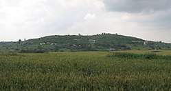
Tell es-Safi
Tell es-Safi (Arabic: تل الصافي, romanized: Tall aṣ-Ṣāfī, "White hill"; Hebrew: תל צפית, Tel Tzafit) was a Palestinian village, located on the southern banks of Wadi 'Ajjur, 35 kilometers (22 mi) northwest of Hebron which had its Palestinian population expelled during the 1948 Arab-Israeli war on orders of Shimon Avidan, commander of the Givati Brigade.[5]
Tell es-Safi تلّ الصافي Tel Tzafit | |
|---|---|
 | |
| Etymology: clear or bright mound. (Name dates from the 12th century)[1] | |
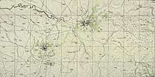
 Tell es-Safi Tell es-Safi in Mandatory Palestine | |
| Coordinates: 31°41′59″N 34°50′49″E | |
| Palestine grid | 135/123 |
| Geopolitical entity | Mandatory Palestine |
| Subdistrict | Hebron |
| Date of depopulation | 9–10 July 1948[2] |
| Area | |
| • Total | 27,794 dunams (27.794 km2 or 10.731 sq mi) |
| Population (1945) | |
| • Total | 1,290[3][4] |
| Cause(s) of depopulation | Military assault by Yishuv forces |
Archaeological excavations show that the site (a tell or archaeological mound) was continuously inhabited since the 5th millennium BCE.[6] On the Madaba Map, the name is Saphitha, while the Crusaders called it Blanche Garde. It is mentioned by Arab geographers in the 13th and 16th centuries. Under the Ottoman Empire, it was part of the district of Gaza. In modern times, the houses were built of sun-dried brick. The villagers were Muslim and cultivated cereals and orchards.
Today the site, known as Tel Tzafit, is an Israeli national park incorporating archaeological remains which some have identified as the Philistine city of Gath, mentioned in the Bible.[7] The remains of the Crusader fort and the Arab village can also be seen on the tell.[6]
Geography

Tell es-Safi sits on a site 300 feet (91 m) above the plain of Philistia and 700 feet (210 m) above sea level, and its white-faced precipices can be seen from the north and west from several hours distant.[7] Tell es-Safi is situated between the Israeli cities of Ashkelon and Beit Shemesh and is one of the country's largest Bronze and Iron Age sites.[8]
History
Excavations at Tell es-Safi since 1996[8] indicate that the site was settled, "virtually continuously from the Chalcolithic until the modern periods."[6]
Bronze and Iron Ages
Stratigraphic evidence attests to settlement in the Late Bronze and Iron Age (I & II) periods.[6] A large city in the Iron Age, the site was "enclosed on three sides by a large man-made siege-moat."[9]
Victor Guérin thought that Tell es-Safi was the "watch-tower" mentioned in Joshua 15:38, based on its etymological meaning,[10] but the site is now believed to be the site of the Philistine city of Gath. The identification was opposed by Albright, who noted its proximity to Tel Miqne (Ekron), but later excavations turned up more supportive evidence for Tell es-Safi.[11][12][13]
Schniedewind writes that Gath was important for the Philistines in the eighth century BCE because of its easily defended geographical position. Albright argued that Tell es-Safi was too close to Tel Miqne/Ekron to be Gath. The sites are only 8 km apart. However, both Tell es-Safi and Tel Miqne were major sites in the Middle Bronze through the Iron Age. The agricultural features of this region of the southern coastal plain may be part of the explanation. Additionally, there is no certainty that the two sites flourished simultaneously. Literary sources suggest that Gath flourished in the Late Bronze and Early Iron Ages until its destruction by the Assyrians in the late eighth century B.C.E. The heyday of Ekron was the seventh century B.C.E., after the site was taken over by the Assyrians as an agricultural administrative center (Dothan and Gitin 1993).[14]
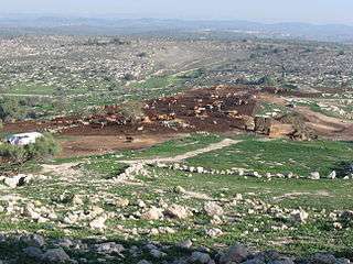
According to 2010 reports, Israeli archaeologists uncovered a Philistines temple and evidence of a major earthquake in biblical times. Other major finds were evidence of destruction by Hazael King of Aram-Damascus around 830 BCE, and evidence of the first Philistine settlement in Canaan.[15] Radiocarbon dating in 2015 showed an early appearance of Philistine material culture in the city.[16]
The Tell es-Safi inscription dated to ca 1000 BCE was found at the site in 2005.
Archaeologists have also discovered a horned altar dating to the ninth century B.C.E. The stone altar is over 3 feet (one meter) tall, and is the earliest ever found in Philistia. The altar features a pair of horns, which is similar to the ancient Israelite altars described in the Hebrew Bible.[17] Nevertheless, the Israelite altars typically have four horns, such as found in Tel Be'er Sheva, for example, as opposed to two.[18]
Crusader and Ayyubid period
During the Crusades, the site was called Blanchegarde, ("White guard"), likely referring to the white rock outcrop next to the site.[19] In 1142 a fort was built on the site by King Fulk, it was dismantled after being taken by Saladin in 1191,[19][20] but reconstructed by Richard of England in 1192. King Richard was nearly captured while inspecting his troops next to the site.[19] Shortly thereafter Blanchegard was retaken by Muslim forces. The remnants of the square castle and its four towers served as a place of some importance in the village well into the 19th century.[7][21][22]
Yaqut al-Hamawi, writing in the 1220s, described the place as a fort near Bayt Jibrin in the Ramleh area.[19][23]
Mamluk period
The Arab geographer Mujir al-Din al-Hanbali noted around 1495 that a village by this name was within the administrative jurisdiction of Gaza.[19][24]
Ottoman era

The village was incorporated into the Ottoman Empire in 1517 with all of Palestine, and in 1596 it appeared in the tax registers being in the nahiya (subdistrict) of Gaza under Gaza Sanjak, with a population of 88 Muslim households; an estimated 484 persons. The villagers paid a fixed tax rate of 25% on a number of crops, including wheat, barley and sesame, and fruits, as well as goats and beehives; a total of 13,300 akçe.[25]
In 1838 Edward Robinson described Tell es-Safieh as a Muslim village in the Gaza district.[26] It was "an isolated oblong hill or ridge, lying from N.to S. in the plain, the highest part being towards the South. The village lies near the middle; lower down."
The Sheikh, Muhammed Sellim, belonged to the 'Azzeh family of Bayt Jibrin. After his family took part in the Peasant's Revolt of 1834, his father and uncle were beheaded and the remaining family was ordered to take up residence at Tell es-Safi.[27]
When Victor Guérin visited in 1863, he saw two small Muslim walīs.[28] An Ottoman village list drawn up around 1870 counted 34 houses and a population of 165 men.[29][30]
In 1883, the PEF's Survey of Western Palestine described Tell al-Safi as a village built of adobe brick with a well in the valley to the north.[31] James Hastings notes that the village contained a sacred wely.[7]
In 1896, the population was around 495 persons.[32]
British Mandate era
In the 1922 census of Palestine conducted by the British Mandate authorities, Tal al-Safi had a population of 644 inhabitants, all Muslims,[33] increasing in the 1931 census to 925, still all Muslim, in a total of 208 inhabited houses.[34]
The villagers of Tall al-Safi had a mosque, a marketplace, and a shrine for a local sage called Shaykh Mohammad. In the 1945 statistics, the total population was 1,290, all Muslims,[4] and the land area was 27,794 dunams of land.[3] Of this, a total of 19,716 dunums of land were used for cereals, 696 dunums were irrigated or used for orchards,[35] while 68 dunams were classified as built-up (urban) areas.[36]
1948, and after
In 1948, Tell es-Safi was the destination for the women and children of Qastina, sent away by the menfolk of Qastina at this time, but they returned after discovering there was insufficient water in the host village to meet the newcomers' needs.[37]
On 7 July Givati commander Shimon Avidan issued orders to the 51st Battalion to take the Tall al-Safi area and "to destroy, to kill and to expel [lehashmid, leharog, u´legaresh] refugees encamped in the area, in order to prevent enemy infiltration from the east to this important position."[38] According to Benny Morris, the nature of the written order and, presumably, accompanying oral explanations, probably left little doubt in the battalion OC's minds that Avidan wanted the area cleared of inhabitants.[39][40]
In 1992, Walid Khalidi wrote that the site was overgrown with wild vegetation, mainly foxtail and thorny plants, interspersed with cactuses, date-palm and olive trees. He noted the remains of a well and the crumbling stone walls of a pool. The surrounding land was planted by Israeli farmers with citrus trees, sunflowers, and grain. A few tents belonging to Bedouin were occasionally pitched nearby.[19]
The site is now an Israeli national park and the site of ongoing archaeological excavations.[41]
See also
References
- Palmer, 1881, p. 275
- Morris, 2004, p. xix, village number #292. Also gives cause of depopulation
- Government of Palestine, Department of Statistics. Village Statistics, April, 1945. Quoted in Hadawi, 1970, p. 50
- Department of Statistics, 1945, p. 23
- Morris, 2004, p. 436
- Negev and Gibson, 2005, p. 445
- Hastings and Driver, 2004, p. 114
- Archaeology: The Science of the Human Past, Mark Sulton
- Wigoder, 2005, pp. 348–9.
- Guérin, V. (1869), p. 90–ff.
- Gath in the Bible gath.wordpress.com
- Bromiley, 1982, pp. 411-413
- Horton Harris (2011). "The location of Ziklag: a review of the candidate sites, based on Biblical, topographical and archaeological evidence". Palestine Exploration Quarterly. 143 (2): 119–133. doi:10.1179/003103211x12971861556954.
- William M. Schniedewind, The Geopolitical History of Philistine Gath. Bulletin of the American Schools of Oriental Research, No. 309 (Feb., 1998), pp. 69–77
- In the Spotlight, Jerusalem Post. 07/29/2010
- RADIOCARBON DATING SHOWS AN EARLY APPEARANCE OF PHILISTINE MATERIAL CULTURE IN TELL ES-SAFI/GATH, PHILISTIA, University of Melbourne
- Exodus 27:1–2; 1 Kings 1:50
- Horned Philistine Altar Discovered at Gath July 26, 2011 biblicalarchaeology.org
- Khalidi, 1992, p. 222
- Conder and Kitchener, 1882, SWP II, p. 440
- Pringle, 1997, p. 93
- Rey, 1871, pp. 123-125; illustrated
- Le Strange, 1890, p.544
- Le Strange, 1890, p. 41
- Hütteroth and Abdulfattah, 1977, p. 150. Quoted in Khalidi, 1992, p. 222
- Robinson and Smith, 1841, vol 3, Appendix 2, p. 119
- Robinson and Smith, 1841, vol 2, pp. 362- 367
- Guérin, 1869, pp. 90 −96
- Socin, 1879, p. 162
- Hartmann, 1883, p. 144 noted 80 houses
- Conder and Kitchener, 1882, pp. 415 – 416 Quoted in Khalidi, 1992, p. 222
- Schick, 1896, p. 123
- Barron, 1923, Table V, Sub-district of Hebron, p. 10
- Mills, 1932, p. 34
- Government of Palestine, Department of Statistics. Village Statistics, April, 1945. Quoted in Hadawi, 1970, p. 94. Quoted in Khalidi, 1992, 222
- Government of Palestine, Department of Statistics. Village Statistics, April, 1945. Quoted in Hadawi, 1970, p. 144
- Morris, 2004, p. 176
- Givati, Operation An-Far, 7 July 1948, IDFA 7011\49\\1. Cited in Morris, 2004, p. 436. Also see note#127, p. 456 According to Morris, Avraham Ayalon (1963): The Givati Brigade Opposite the Egyptian Invader. pp. 227-28 "gives a laundered version of the order, – which I (unfortunately) used in the original edition of The Birth." The "laundered" version does not contain the words: "to destroy, to kill".
- Morris, 2004, p. 437
- Operation An-Far
- Looking for a Wider View of History, Israeli Archaeologists Are Zooming In
Bibliography
- Barron, J.B., ed. (1923). Palestine: Report and General Abstracts of the Census of 1922. Government of Palestine.
- Bliss, F.J.; Macalister, R.A.S. (1902). Excavations in Palestine During the Years 1898–1900. London. (pp. 28-43)
- Bliss, F.J. (1899). "Second Report on the Excavations at Tell Es-Safi". Quarterly Statement - Palestine Exploration Fund. 31: 317-333.
- Bliss, F.J. (1900). "Third Report on the Excavations at Tell Es-Safi". Quarterly Statement - Palestine Exploration Fund. 32: 16-86.
- Bromiley, G.W. (1982). International Standard Bible Encyclopedia. II: E-J. ISBN 0-8028-3782-4.
- Clermont-Ganneau, C.S. (1896). [ARP] Archaeological Researches in Palestine 1873-1874, translated from the French by J. McFarlane. 2. London: Palestine Exploration Fund. ( p.440. )
- Conder, C.R.; Kitchener, H.H. (1882). The Survey of Western Palestine: Memoirs of the Topography, Orography, Hydrography, and Archaeology. 2. London: Committee of the Palestine Exploration Fund.
- Department of Statistics (1945). Village Statistics, April, 1945. Government of Palestine.
- Guérin, V. (1869). Description Géographique Historique et Archéologique de la Palestine (in French). 1: Judee, pt. 2. Paris: L'Imprimerie Nationale.
- Hadawi, S. (1970). Village Statistics of 1945: A Classification of Land and Area ownership in Palestine. Palestine Liberation Organization Research Center.
- Hastings, J.; Driver, S.R. (2004). A Dictionary of the Bible: Volume II: (Part I: Feign – Hyssop). The Minerva Group, Inc. ISBN 9781410217240.
- Hartmann, M. (1883). "Die Ortschaftenliste des Liwa Jerusalem in dem türkischen Staatskalender für Syrien auf das Jahr 1288 der Flucht (1871)". Zeitschrift des Deutschen Palästina-Vereins. 6: 102–149.
- Hütteroth, Wolf-Dieter; Abdulfattah, Kamal (1977). Historical Geography of Palestine, Transjordan and Southern Syria in the Late 16th Century. Erlanger Geographische Arbeiten, Sonderband 5. Erlangen, Germany: Vorstand der Fränkischen Geographischen Gesellschaft. ISBN 3-920405-41-2.
- Khalidi, W. (1992). All That Remains: The Palestinian Villages Occupied and Depopulated by Israel in 1948. Washington D.C.: Institute for Palestine Studies. ISBN 0-88728-224-5.
- Le Strange, G. (1890). Palestine Under the Moslems: A Description of Syria and the Holy Land from A.D. 650 to 1500. London: Committee of the Palestine Exploration Fund.
- Macalister, R.A.S. (1925). A century of excavation in Palestine. London: The Religious Tract Society. (pp. 51, 56, 59, 124, 189, 275)
- Mills, E., ed. (1932). Census of Palestine 1931. Population of Villages, Towns and Administrative Areas. Jerusalem: Government of Palestine.
- Morris, B. (2004). The Birth of the Palestinian Refugee Problem Revisited. Cambridge University Press. ISBN 978-0-521-00967-6.
- Negev, Avraham; Gibson, S. (2005). Archaeological Encyclopedia of the Holy Land. Continuum International Publishing Group. ISBN 9780826485717.
- Palmer, E.H. (1881). The Survey of Western Palestine: Arabic and English Name Lists Collected During the Survey by Lieutenants Conder and Kitchener, R. E. Transliterated and Explained by E.H. Palmer. Committee of the Palestine Exploration Fund.
- Petersen, Andrew (2001). A Gazetteer of Buildings in Muslim Palestine (British Academy Monographs in Archaeology). 1. Oxford University Press. ISBN 978-0-19-727011-0. (pp. 291–292)
- Pringle, Denys (1997). Secular buildings in the Crusader Kingdom of Jerusalem: an archaeological Gazetter. Cambridge University Press. ISBN 0521 46010 7.
- Rey, E. G. (1871). Etude sur les monuments de l'architecture militaire des croisés en Syrie et dans l'île de Chypre (in French). Paris: L'Imprimerie Nationale.
- Robinson, E.; Smith, E. (1841). Biblical Researches in Palestine, Mount Sinai and Arabia Petraea: A Journal of Travels in the year 1838. 2. Boston: Crocker & Brewster.
- Robinson, E.; Smith, E. (1841). Biblical Researches in Palestine, Mount Sinai and Arabia Petraea: A Journal of Travels in the year 1838. 3. Boston: Crocker & Brewster.
- Schick, C. (1896). "Zur Einwohnerzahl des Bezirks Jerusalem". Zeitschrift des Deutschen Palästina-Vereins. 19: 120–127.
- Socin, A. (1879). "Alphabetisches Verzeichniss von Ortschaften des Paschalik Jerusalem". Zeitschrift des Deutschen Palästina-Vereins. 2: 135–163.
- Wigoder, Geoffrey (2005). The Illustrated Dictionary and Concordance of the Bible. Sterling Publishing Company, Inc. ISBN 9781402728204.
- Wilson, C.W., ed. (c. 1881). Picturesque Palestine, Sinai and Egypt. 3. New York: D. Appleton.(p.158 -p.161 )
External links
- Tall-al-Safi Palestine Remembered
- Tall al-Safi, Zochrot
- Survey of Western Palestine, Map 16: IAA, Wikimedia commons
- Tall al-Safi, at Khalil Sakakini Cultural Center
| Authority control |
|
|---|