Bayt Nabala
Bayt Nabala or Beit Nabala was a Palestinian Arab village in the Ramle Subdistrict in Palestine that was destroyed during the 1948 Arab–Israeli War. The village was in the territory allotted to the Arab state under the 1947 UN Partition Plan. Its population in 1945, before the war, was 2,310.
Bayt Nabala بيت نبالا Bayt Nabala, Beit-Nabbala | |
|---|---|
 Former schoolhouse of Bayt Nabala, presently used by the Jewish National Fund in Beit Nehemia | |
| Etymology: "The house of archery"[1] | |
 Bayt Nabala | |
| Coordinates: 31°59′11″N 34°57′32″E | |
| Palestine grid | 146/154 |
| Geopolitical entity | Mandatory Palestine |
| Subdistrict | Ramle |
| Date of depopulation | May 13, 1948[2] |
| Area | |
| • Total | 15,051 dunams (15.051 km2 or 5.811 sq mi) |
| Population (1945) | |
| • Total | 2,310[4][3] |
| Cause(s) of depopulation | Abandonment on Arab orders |
| Current Localities | Kfar Truman,[5] and Beit Nehemia[5] |
It was occupied by Israeli forces on May 13, 1948[2] and was completely destroyed by them on September 13, 1948.[6] Village refugees were scattered around Deir 'Ammar, Ramallah city, Bayt Tillow, Rantis, and Jalazone refugee camps north of Ramallah. Some of the clans that lived in Bayt Nabala include the Nakhleh, Safi, AL-Sharaqa, al-Khateeb, Saleh and Zaid families. Today the area is part of the Israeli town of Beit Nehemia.
History

In the 1596 tax record, Bayt Nabala was part of the Ottoman Empire, nahiya (subdistrict) of Ramla under the Liwa of Gaza, with a population of 54 Muslim households, an estimated 297 people. They paid a fixed tax-rate of 33,3 % on a number of crops, including wheat, barley, olives, fruit, as well as on goats, beehives and a press that was used for processing either olives or grapes, in addition to occasional revenues; a total of 8,688 akçe.[7]
In 1838 Edward Robinson noted Bayt Nabala from the tower in Ramle.[8] In 1870 Victor Guérin visited and found the village to have about 900 inhabitants.[9] Socin found from an official Ottoman village list from about the same year that Bayt Nabala had 108 houses and a population of 427, though the population count included men, only.[10] Hartmann found that Bet Nebala had 118 houses.[11]
In 1882, the PEF's Survey of Western Palestine described Bayt Nabala as being of moderate size, situated at the edge of a plain.[12]
British Mandate era

The school was founded in 1921 and had about 230 students in 1946-47.[13]
In the 1922 census of Palestine, conducted by the British Mandate authorities, Bait Nabala had a population of 1,324 inhabitants; 1,321 Muslims and 3 Christians,[14] increasing in the 1931 census to 1758, all Muslims, in a total of 471 houses.[15]
In the 1945 statistics, the village had a population of 2,310 Muslims,[4] while the total land area was 15,051 dunams, according to an official land and population survey.[3] A total of 226 dunums of village land was used for citrus and bananas, 10,197 dunums were used for cereals, 1,733 dunums were irrigated or used for orchards,[5][16] while 123 dunams were classified as built-up public areas.[17]
 Bayt Nabala 1942 1:20,000
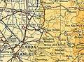 Bayt Nabala 1945 1:250,000
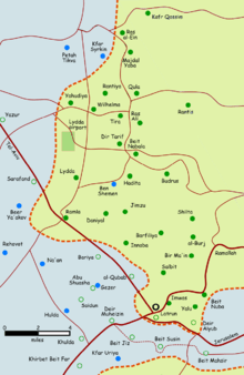 Depopulated villages in the Ramle Subdistrict
1948 war and aftermath
Benny Morris writes that the village residents abandoned it on Arab orders on 13 May 1948. However, according to Walid Khalidi, this cannot be confirmed.[5]
The Palestinian historian Walid Khalidi described the village site in 1992: "The site is overgrown with grass, thorny bushes, and cypress and fig trees. It lies on the east side of the settlement of Beyt Nechemya, due east of the road from the Lod (Lydda) airport. On its fringes are the remains of quarries and crumbled houses. Sections of walls from the houses still stand. The surrounding land is cultivated by the Israeli settlements."[5]
Culture
According to the Palestinian Heritage Foundation, Beit Nabala dresses (together with those of the village of Dayr Tarif), "were usually done on cotton, velvet or kermezot silk fabric. Taffeta inserts embroidered in Bethlehem style couching-stitch in gold and silk cord were attached to the yoke, chest panel, sleeves and skirt. In the 1930s black velvet material became popular, and dresses were embroidered in couching straight on the fabric with brown or orange couching embroidery which later became famous for this area."[18]
See also
- Palestinian costumes
- Killings and massacres during the 1948 Palestine war
- List of Arab towns and villages depopulated during the 1948 Palestinian exodus
References
- Notes
- Palmer, 1881, p. 226
- Morris, 2004, p. xix, village #222. Also gives the cause for depopulation.
- Government of Palestine, Department of Statistics. Village Statistics, April, 1945. Quoted in Hadawi, 1970, p. 66
- Department of Statistics, 1945, p. 29
- Khalidi, 1992, p. 366
- Morris, 2004, p. 354.
- Hütteroth and Abdulfattah, 1977, p. 153, cited in Khalidi, 1992, p. 365
- Robinson and Smith, 1841, vol. 3, p. 30
- Guérin, 1875, pp. 67 ff, 70
- Socin, 1879, p. 147
- Hartmann, 1883, p. 138
- Conder and Kitchener, 1882, SWP II, p. 296, cited in Khalidi, 1992, p.365
- Khalidi, 1992, p. 365
- Barron, 1923, Table VII, Sub-district of Ramleh, p.22
- Mills, 1932, p. 18.
- Government of Palestine, Department of Statistics. Village Statistics, April, 1945. Quoted in Hadawi, 1970, p. 114
- Government of Palestine, Department of Statistics. Village Statistics, April, 1945. Quoted in Hadawi, 1970, p. 164
- "Lydda-Ramleh Region, Palestinian Heritage Foundation". Archived from the original on 2006-12-24. Retrieved 2006-11-22.
Bibliography
- Barron, J.B., ed. (1923). Palestine: Report and General Abstracts of the Census of 1922. Government of Palestine.
- Conder, C.R.; Kitchener, H.H. (1882). The Survey of Western Palestine: Memoirs of the Topography, Orography, Hydrography, and Archaeology. 2. London: Committee of the Palestine Exploration Fund.
- Department of Statistics (1945). Village Statistics, April, 1945. Government of Palestine.
- Guérin, V. (1875). Description Géographique Historique et Archéologique de la Palestine (in French). 2: Samarie, pt. 2. Paris: L'Imprimerie Nationale.
- Hadawi, S. (1970). Village Statistics of 1945: A Classification of Land and Area ownership in Palestine. Palestine Liberation Organization Research Center. Retrieved 2009-07-22.
- Hartmann, M. (1883). "Die Ortschaftenliste des Liwa Jerusalem in dem türkischen Staatskalender für Syrien auf das Jahr 1288 der Flucht (1871)". Zeitschrift des Deutschen Palästina-Vereins. 6: 102–149.
- Hütteroth, Wolf-Dieter; Abdulfattah, Kamal (1977). Historical Geography of Palestine, Transjordan and Southern Syria in the Late 16th Century. Erlanger Geographische Arbeiten, Sonderband 5. Erlangen, Germany: Vorstand der Fränkischen Geographischen Gesellschaft. ISBN 3-920405-41-2.
- Khalidi, W. (1992). All that Remains: The Palestinian Villages Occupied and Depopulated by Israel in 1948. Washington DC: Institute for Palestine Studies. ISBN 0-88728-224-5.
- Mills, E., ed. (1932). Census of Palestine 1931. Population of Villages, Towns and Administrative Areas. Jerusalem: Government of Palestine.
- Morris, B. (2004). The Birth of the Palestinian Refugee Problem Revisited. Cambridge University Press. ISBN 0-521-00967-7.
- Palmer, E.H. (1881). The Survey of Western Palestine: Arabic and English Name Lists Collected During the Survey by Lieutenants Conder and Kitchener, R. E. Transliterated and Explained by E.H. Palmer. Committee of the Palestine Exploration Fund.
- Robinson, E.; Smith, E. (1841). Biblical Researches in Palestine, Mount Sinai and Arabia Petraea: A Journal of Travels in the year 1838. 3. Boston: Crocker & Brewster.
- Socin, A. (1879). "Alphabetisches Verzeichniss von Ortschaften des Paschalik Jerusalem". Zeitschrift des Deutschen Palästina-Vereins. 2: 135–163.
External links
- Palestine Remembered - Bayt Nabala
- Survey of Western Palestine, Map 14: IAA, Wikimedia commons
- Bayt Nabala, Zochrot
- Israel campaign throws spotlight on Jewish refugees from Arab lands, 28 September 2012, BBC
- Bayt Nabala from Khalil Sakakini Cultural Center
- Bayt Nabala, from PalestineFamily.net
- Nabaly Net