Dayr al-Hawa
Dayr al-Hawa (Arabic: دير الهوا) was a Palestinian Arab village in the Jerusalem Subdistrict. The village was depopulated during the 1948 Arab-Israeli War on October 19, 1948 by the Fourth Battalion of the Har'el Brigade of Operation ha-Har. It was located 18.5 km west of Jerusalem.
Dayr al-Hawa دير الهوا | |
|---|---|
| Etymology: The Monastery of the Wind[1] | |
 Dayr al-Hawa | |
| Coordinates: 31°45′05″N 35°02′14″E | |
| Palestine grid | 153/128 |
| Geopolitical entity | Mandatory Palestine |
| Subdistrict | Jerusalem |
| Date of depopulation | October 19–20, 1948[2] |
| Area | |
| • Total | 5,907 dunams (5.907 km2 or 2.281 sq mi) |
| Population (1945) | |
| • Total | 60[3][4][5] |
| Cause(s) of depopulation | Military assault by Yishuv forces |
History
Coins and ceramics from the Byzantine era have been found here.[6]
Ottoman era
In 1838, Edward Robinson called it a "lofty" village, on the brink of a valley.[7] It was further noted as a Muslim village, located in the District of el-Arkub, southwest of Jerusalem.[8] In 1856 the village was named D. el Hawa on the map of Southern Palestine that Heinrich Kiepert published that year.[9]
Victor Guérin, visiting the village in 1863, wrote that Dayr al-Hawa "probably owes its name, monastery of the wind, to its high position".[10]
An Ottoman village list from around 1870 showed that Der el-Hawa had 32 houses and a population of 103, though the population count included men, only.[11][12]
In 1883, the PEF's Survey of Western Palestine described it as "a village standing high, on a knoll rising from a high ridge, with a deep valley to the north. It has several high houses in it. On the west is a good spring. The ground is covered with brushwood all round the place."[13]
In 1896 the population of Der el-hawa was estimated to be about 162 persons.[14]
British Mandate era

In the 1922 census of Palestine conducted i by the British Mandate authorities, Dair al-Hawa had a population of 38 residents; all Muslims,[15] increasing in the 1931 census to 47 inhabitants, in 11 houses.[16]
In the 1945 statistics the village had a population of 60 Muslims,[4] with a total of 5,907 dunums of land.[5] Of this, 58 dunams were for irrigable land or plantations, 1,565 for cereals,[17] while 4 dunams were built-up land.[18]
A mosque was located in the western part of the village and there was a shrine for a local sage known as al-Shaykh Sulayman. Near the ruins of the old village now stands the Israeli moshav, Nes Harim,[19] however, it is not on village land. (It is on the land of Bayt 'Itab.)[20]
During the 1948 it was defended by the local militia and the Egyptian Army/Muslim Brotherhood Battalion.
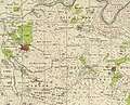 Dayr al-Hawa, Mandate survey, 1:20,000
 Dayr al-Hawa, 1945, 1:20,000
See also
References
- Palmer, 1881, p.293
- Morris, 2004, p. xx, village #339. Also gives cause of depopulation.
- Khalidi, 1992, p. 285
- Department of Statistics, 1945, p. 24
- Government of Palestine, Department of Statistics. Village Statistics, April, 1945. Quoted in Hadawi, 1970, p. 56
- Dauphin, 1998, p. 908
- Robinson and Smith, 1841, vol 2, pp. 326, 340, 342, 426
- Robinson and Smith, 1841, vol 3, Appendix 2, p. 125
- Kiepert, 1856, Map of Southern Palestine
- Guerin, 1869, p. 321
- Socin, 1879, p. 152 It was noted in the Hebron district
- Hartmann, 1883, p. 145 also showed 32 houses
- Conder and Kitchener, 1883, p. 24
- Schick, 1896, p. 125
- Barron, 1923, Table VII, Sub-district of Ramleh, p. 21
- Mills, 1932, p. 19
- Government of Palestine, Department of Statistics. Village Statistics, April, 1945. Quoted in Hadawi, 1970, p. 102
- Government of Palestine, Department of Statistics. Village Statistics, April, 1945. Quoted in Hadawi, 1970, p. 152
- Zvi Dror, Har'el: Palmach brigade in Jerusalem, Ha-kibbutz ha-meuchad 2005, p. 269 (Hebrew)
- Khalidi, 1992, p. 286
Bibliography
- Barron, J.B., ed. (1923). Palestine: Report and General Abstracts of the Census of 1922. Government of Palestine.
- Clermont-Ganneau, C.S (1896). [ARP] Archaeological Researches in Palestine 1873-1874, translated from the French by J. McFarlane. 2. London: Palestine Exploration Fund. (p. 219)
- Conder, C.R.; Kitchener, H.H. (1883). The Survey of Western Palestine: Memoirs of the Topography, Orography, Hydrography, and Archaeology. 3. London: Committee of the Palestine Exploration Fund.
- Dauphin, Claudine (1998). La Palestine byzantine, Peuplement et Populations. BAR International Series 726 (in French). III : Catalogue. Oxford: Archeopress. ISBN 0-860549-05-4.
- Department of Statistics (1945). Village Statistics, April, 1945. Government of Palestine.
- Guérin, V. (1869). Description Géographique Historique et Archéologique de la Palestine (in French). 1: Judee, pt. 3. Paris: L'Imprimerie Nationale.
- Hadawi, S. (1970). Village Statistics of 1945: A Classification of Land and Area ownership in Palestine. Palestine Liberation Organization Research Center.
- Hartmann, M. (1883). "Die Ortschaftenliste des Liwa Jerusalem in dem türkischen Staatskalender für Syrien auf das Jahr 1288 der Flucht (1871)". Zeitschrift des Deutschen Palästina-Vereins. 6: 102–149.
- Khalidi, W. (1992). All That Remains: The Palestinian Villages Occupied and Depopulated by Israel in 1948. Washington D.C.: Institute for Palestine Studies. ISBN 0-88728-224-5.
- Mills, E., ed. (1932). Census of Palestine 1931. Population of Villages, Towns and Administrative Areas. Jerusalem: Government of Palestine.
- Morris, B. (2004). The Birth of the Palestinian Refugee Problem Revisited. Cambridge University Press. ISBN 978-0-521-00967-6.
- Palmer, E.H. (1881). The Survey of Western Palestine: Arabic and English Name Lists Collected During the Survey by Lieutenants Conder and Kitchener, R. E. Transliterated and Explained by E.H. Palmer. Committee of the Palestine Exploration Fund.
- Robinson, E.; Smith, E. (1841). Biblical Researches in Palestine, Mount Sinai and Arabia Petraea: A Journal of Travels in the year 1838. 2. Boston: Crocker & Brewster.
- Robinson, E.; Smith, E. (1841). Biblical Researches in Palestine, Mount Sinai and Arabia Petraea: A Journal of Travels in the year 1838. 3. Boston: Crocker & Brewster.
- Schick, C. (1896). "Zur Einwohnerzahl des Bezirks Jerusalem". Zeitschrift des Deutschen Palästina-Vereins. 19: 120–127.
- Socin, A. (1879). "Alphabetisches Verzeichniss von Ortschaften des Paschalik Jerusalem". Zeitschrift des Deutschen Palästina-Vereins. 2: 135–163.
External links
- Welcome To Dayr al-Hawa
- Dayr al-Hawa, Zochrot
- Survey of Western Palestine, Map 17: IAA, Wikimedia commons
- Dayr Al-Hawa, from the Khalil Sakakini Cultural Center
- Dayr al-Hawa دير الهوا, Palestine Family.net