Al-Samakiyya
Al-Samakiyya was a Palestinian Arab village in the Tiberias Subdistrict. It was depopulated during the 1947–1948 Civil War in Mandatory Palestine on May 4, 1948, under Operation Matat. It was located 11 km northeast of Tiberias, near the Wadi al-Wadabani.
Al-Samakiyya تلحوم/السمكية | |
|---|---|
Village | |
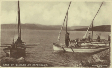
 Al-Samakiyya villagers, postcard from 1902 | |
| Etymology: ’Arab es Semakîyeh, the Semakîyeh (fisher) Arabs[1] | |
 Al-Samakiyya | |
| Coordinates: 32°53′02″N 35°34′37″E | |
| Palestine grid | 204/254 |
| Geopolitical entity | Mandatory Palestine |
| Subdistrict | Tiberias |
| Date of depopulation | Not known[2] |
| Area | |
| • Total | 10,526 dunams (10.526 km2 or 4.064 sq mi) |
| Population (1945) | |
| • Total | 380[4][3] |
| Current Localities | Amnun,[5] Korazim[5] |
History
In 1838, Edward Robinson noted the bedawin tribe of es-Semekiyeh, who kept some buildings in Abu Shusha as magazines.[6] The village was located by Tel Hum, which has been identified with Capernaum.[7]
British Mandate era
In the 1922 census of Palestine conducted by the British Mandate authorities, the population of Samakiyeh was 193 Muslims,[8] increasing in the 1931 census to 290; 266 Muslims and 24 Christians, in a total of 60 houses.[9]
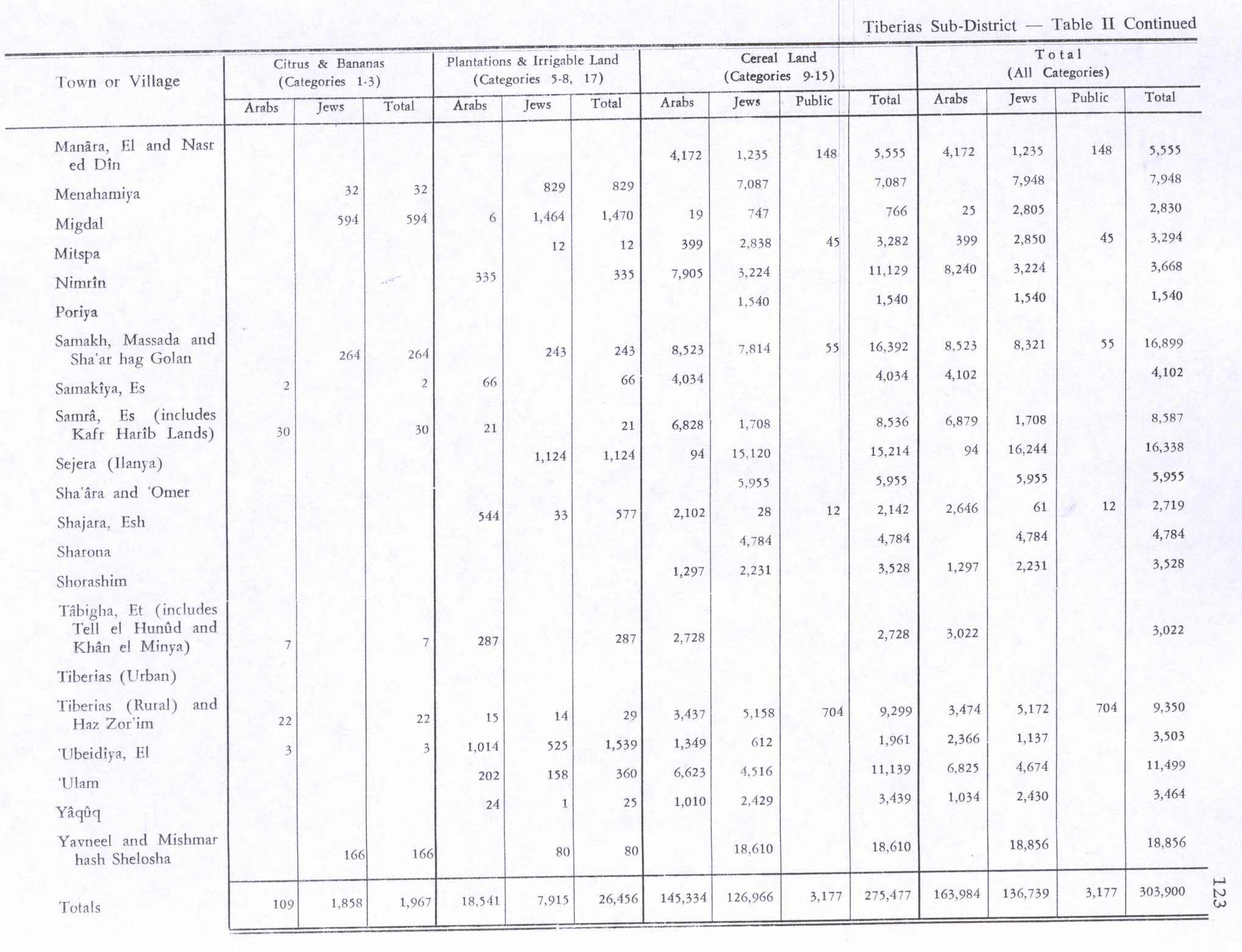
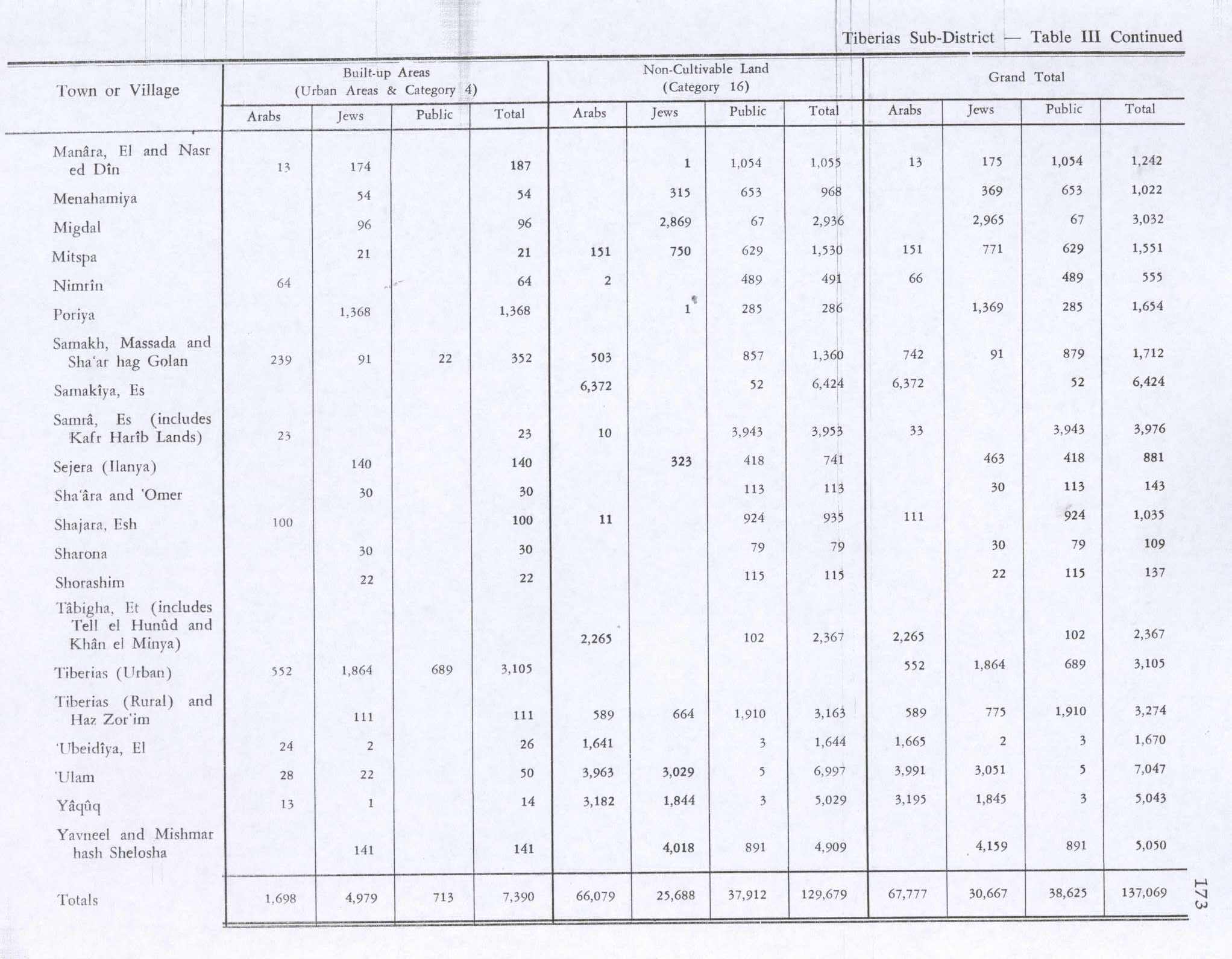
In the 1945 statistics Es Samakiya had a population of 380; 330 Muslims and 50 Christians,[4] with 10,526 dunams of land.[3] Of this, 2 dunams were used for citrus and bananas, 66 for plantations and irrigable land, 4,034 dunams for cereals,[10] while a total of 6,424 dunams were classified as non-cultivable area.[11]
al-Samakiyya had an Italian monastery, a Franciscan church, and a Greek Orthodox church.[5]
1948, aftermath
On May 5, 1948, Allon launched Operation Broom, Operation Matateh, in order to clear the area of its Bedouin inhabitants.[2][12]
Amnun and Korazim were both established on Al-Samakiyya land in 1983.[5]
In 1992 the village site was described: "The village site is covered with wild vegetation, piles of basalt stones, and date palm trees. Part of the surrounding land is used as pasture, and the other part is planted with fruit and walnut trees."[5]
References
- Palmer, 1881, p. 123
- Morris, 2004, p. xvii, village #373. Gives both date and cause of depopulation as "Not known"
- Government of Palestine, Department of Statistics. Village Statistics, April, 1945. Quoted in Hadawi, 1970, p. 72
- Department of Statistics, 1945, p. 12
- Khalidi, 1992, p. 539
- Robinson and Smith, 1841, vol 3, p. 286, cited in Khalidi, 1992, p. 539
- Conder and Kitchener, 1881, SWP I, pp. 371, 417
- Barron, 1923, Table IX, Sub-district of Tiberias, p. 40
- Mills, 1932, p. 85
- Government of Palestine, Department of Statistics. Village Statistics, April, 1945. Quoted in Hadawi, 1970, p. 123
- Government of Palestine, Department of Statistics. Village Statistics, April, 1945. Quoted in Hadawi, 1970, p. 173
- Morris, 2004, pp. 249-250, notes #694-698, p. 302
Bibliography
- Barron, J. B., ed. (1923). Palestine: Report and General Abstracts of the Census of 1922. Government of Palestine.
- Conder, C.R.; Kitchener, H. H. (1881). The Survey of Western Palestine: Memoirs of the Topography, Orography, Hydrography, and Archaeology. 1. London: Committee of the Palestine Exploration Fund.
- Department of Statistics (1945). Village Statistics, April, 1945. Government of Palestine.
- Hadawi, S. (1970). Village Statistics of 1945: A Classification of Land and Area ownership in Palestine. Palestine Liberation Organization Research Center. Archived from the original on 2018-12-08. Retrieved 2009-08-18.
- Khalidi, W. (1992). All That Remains: The Palestinian Villages Occupied and Depopulated by Israel in 1948. Washington D.C.: Institute for Palestine Studies. ISBN 0-88728-224-5.
- Mills, E., ed. (1932). Census of Palestine 1931. Population of Villages, Towns and Administrative Areas. Jerusalem: Government of Palestine.
- Morris, B. (2004). The Birth of the Palestinian Refugee Problem Revisited. Cambridge University Press. ISBN 978-0-521-00967-6.
- Palmer, E. H. (1881). The Survey of Western Palestine: Arabic and English Name Lists Collected During the Survey by Lieutenants Conder and Kitchener, R. E. Transliterated and Explained by E.H. Palmer. Committee of the Palestine Exploration Fund.
- Robinson, E.; Smith, E. (1841). Biblical Researches in Palestine, Mount Sinai and Arabia Petraea: A Journal of Travels in the year 1838. 3. Boston: Crocker & Brewster.
External links
- Welcome To al-Samakiyya
- al-Samakiyya, Zochrot
- Survey of Western Palestine, Map 6: IAA, Wikimedia commons
- Al-Samakiyya from the Khalil Sakakini Cultural Center
- Al-Samakiyyeh (Talhum) from Dr. Moslih Kanaaneh