Khirbat Umm Burj
Khirbat Umm Burj was a Palestinian Arab village in the Hebron Subdistrict, sometimes designated in modern maps as Burgin.[6] It occupied an extensive site, stretching about 30 dunams (7.4 acres) on the crest of a hill, rising some 430 metres (1,410 ft) above sea level, and commanding a good prospect of the surrounding region. It was depopulated during the 1948 Arab–Israeli War on October 28, 1948 during the third stage of Operation Yo'av under the command of Yigal Allon. The site is located 17 km northwest of Hebron.
Khirbat Umm Burj خربة أمْ برج' | |
|---|---|
 Khirbat Umm Burj (ruined house) | |
| Etymology: the mother of the tower [1] | |
 Khirbat Umm Burj | |
| Coordinates: 31°38′12″N 34°58′11″E | |
| Palestine grid | 147/115 |
| Geopolitical entity | Mandatory Palestine |
| Subdistrict | Hebron |
| Date of depopulation | Not known[2] |
| Area | |
| • Total | 13,083 dunams (13.083 km2 or 5.051 sq mi) |
| Population (1945) | |
| • Total | 140[4][3] |
| Current Localities | Nehusha[5] |
History
The site was occupied from the Iron Age. A large ancient necropolis was here, including a church or synagogue, residential buildings and numerous agricultural installations.[7] Israeli archaeologists, Amir Ganor and Boaz Zissu, think that Umm Burj may be a corruption of the 1st-century Jewish village, Kefar Bish, a view earlier rejected by Klein who said that Kefar Bish still bears its namesake in the nearby ruin of Khirbet al-Bis.[8][9] In the late 19th century, extensive Christian remains were noted in the area surrounding Umm Burj.[10] Finnish scholar, Aapeli Saarisalo, visited the site of Umm Burj in the earlier 20th-century, and described its ruins as being those of Byzantine and Arab origin.[11]
Ottoman era
In 1838 Um Burj was noted as village, located in the area between the mountains and Gaza, but subject to the government of el-Khulil.[12]
In 1863, Victor Guérin passed north of Khirbat Umm Burj, and described the village as being on a mountain, dominating the surroundings.[13]
An Ottoman village list from about 1870 found that um-burdsch had a population of 150, in 25 houses, though the population count included men, only.[14][15]
French orientalist and archaeologist, Charles Clermont-Ganneau, visited the site in 1874 where he noticed a well situated nearby, called Bîr Hârûn, surmounted with a rude structure, near which were troughs hollowed out in large stone blocks.[16]
In 1883, the PEF's Survey of Western Palestine (SWP) described Umm Burj as: "A ruined village, with a central tower; apparently not ancient; caves and cisterns round it, and a well."[17] Khalidi believed that the SWP assumption that the tower was not ancient might have been wrong.[18]
British Mandate era
In the 1931 census of Palestine, Umm Burj and Sanabra, listed in the sub-district of Hebron, had a joint population of 119 Muslims, in a total of 26 houses.[19]
In the 1945 statistics it had a population of 140 Muslims,[4] with a total of 13,083 dunums of land.[3] Of this, 28 dunums were irrigated or used for plantations, 3,546 were for cereal,[20] while 15 dunams were built-up (urban) areas.[21]
The villagers used to obtain drinking water from three wells on the northern outskirts of the village.[18]
1948 and aftermath
After the 1948 Arab–Israeli War, the ruin of Umm Burj remained under Israeli control under the terms of the 1949 Armistice Agreements[22] between Israel and Jordan. Today, the site lies in the Adullam-France Park.
The moshav of Nehusha was established in 1955 on land that had belonged to the village, west of the village site,[23] but collapsed in 1968. It was re-established in 1981.
Archaeology
In the years 1995–2012, archaeological fieldwork was conducted by a team of archaeologists at Khirbet Umm Burj on behalf of the Israel Antiquities Authority (IAA), among whom were Boaz Zissu and Amir Golan, et al., where they uncovered at the site two Byzantine churches, and a Jewish inscription incised on a doorjamb of an underground room in a hiding tunnel system.[24] In 2013, the archaeological survey was continued at the site by Peter Gendelman, Alon Klein, and Amir Ganor, on behalf of the Israel Antiquities Authority,[25] and in 2014 an archaeological excavation of the site was led by Hagit Noygborn on behalf of Israel Antiquities Authority.[26]
Gallery
 Khirbat Umm Burj
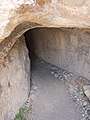 Tunnel at Hurvat Burgin (Khirbat Umm Burj)
 Cave and pit in Umm Burj
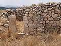
 Old structure of house
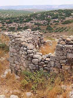
 General view of remaining walls at Khirbat Umm Burj
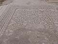 Mosaic in ruined Byzantine Church at Khirbat Umm Burj
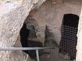 Staircase leading down to a cavern
_with_general_view.jpg) General view
General view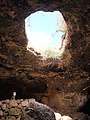 Open roof of cavern (Hurvat Burgin)
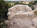 Plastered pool from Ottoman period at Khirbat Umm Burj
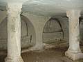 "Cave of the Column"
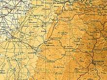 Khirbat Umm Burj 1945 1:250,000
 Khirbat Umm Burj 1947 1:20,000
References
- Palmer, 1881, p. 408
- Morris, 2004, p. xix village #326. Morris gives both cause and date of depopulation as "Not known".
- Government of Palestine, Department of Statistics. Village Statistics, April, 1945. Quoted in Hadawi, 1970, p. 50
- Department of Statistics, 1945, p. 23
- Khalidi, 1992, p. 224
- In the Topographical Map (Map # 9, Jerusalem Corridor) published by Israel's Nature Protection Society, the site is listed as Ḥurvat Burjin.
- Ganor and Klein, 2011, Horbat Burqin, Preliminary Report
- Boaz Zissu and Amir Ganor, Survey and Excavations at Ḥorbat Burgin in the Judean Shephelah: Burial Caves, Hiding Complexes and Installations of the Second Temple and Byzantine Periods, ʿAtiqot (publication of the Israel Antiquities Authority), Issue 58 (2008), p. 63; Zissu, Boaz (2008). "Survey and Excavations at Ḥorbat Burgin in the Judean Shephelah: Burial Caves, Hiding Complexes and Installations of the Second Temple and Byzantine Periods". 'Atiqot (58): 60–64. JSTOR 23464336.
- Samuel Klein, The Twenty-four City Councils in Judea (ארבע ועשרים בולאות שביהודה), Vienna 1933, p. 293 (Hebrew)
- Warren and Conder, 1884, p. 446
- Aapeli Saarisalo, "Topographical Researches in the Shephelah", in: The Journal of the Palestine Oriental Society, vol. XI, Jerusalem 1931, p. 16
- Robinson and Smith, 1841, vol 3, Appendix 2, p. 117
- Guérin, 1869, p. 336
- Socin, 1879, p. 162
- Hartmann, 1883, p. 148
- Clermont-Ganneau, 1896, ARP, vol 2, p. 462
- Conder and Kitchener, 1883, SWP III, p. 380
- Khalidi, 1992, p. 223
- Mills, 1932, p. 33
- Government of Palestine, Department of Statistics. Village Statistics, April, 1945. Quoted in Hadawi, 1970, p. 93
- Government of Palestine, Department of Statistics. Village Statistics, April, 1945. Quoted in Hadawi, 1970, p. 143
- The 1949 Armistice Agreement between Israel and Jordan
- Khalidi, Walid (1992), All That Remains: The Palestinian Villages Occupied and Depopulated by Israel in 1948, Washington D.C.: Institute for Palestine Studies, pp. 217, 224, ISBN 0-88728-224-5,
- Judea and Samaria Research Studies, Miriam Billig (ed.), vol. 22, Ariel University: Ariel 2013, pp. 19–20, 151–ff.
- Israel Antiquities Authority, Excavators and Excavations Permit for Year 2013, Survey Permit # A-6748
- Israel Antiquities Authority, Excavators and Excavations Permit for Year 2014, Survey Permit # A-7061
Bibliography
- Clermont-Ganneau, C.S. (1896). [ARP] Archaeological Researches in Palestine 1873-1874, translated from the French by J. McFarlane. 2. London: Palestine Exploration Fund.
- Conder, C.R.; Kitchener, H.H. (1883). The Survey of Western Palestine: Memoirs of the Topography, Orography, Hydrography, and Archaeology. 3. London: Committee of the Palestine Exploration Fund.
- Department of Statistics (1945). Village Statistics, April, 1945. Government of Palestine.
- Ganor, Amir; Klein, Alon (2011-10-11). "Horbat Burgin" (123). Hadashot Arkheologiyot – Excavations and Surveys in Israel. Cite journal requires
|journal=(help) - Guérin, V. (1869). Description Géographique Historique et Archéologique de la Palestine (in French). 1: Judee, pt. 3. Paris: L'Imprimerie Nationale.
- Hadawi, S. (1970). Village Statistics of 1945: A Classification of Land and Area ownership in Palestine. Palestine Liberation Organization Research Center.
- Hartmann, M. (1883). "Die Ortschaftenliste des Liwa Jerusalem in dem türkischen Staatskalender für Syrien auf das Jahr 1288 der Flucht (1871)". Zeitschrift des Deutschen Palästina-Vereins. 6: 102–149.
- Khalidi, W. (1992). All That Remains: The Palestinian Villages Occupied and Depopulated by Israel in 1948. Washington D.C.: Institute for Palestine Studies. ISBN 0-88728-224-5.
- Mills, E., ed. (1932). Census of Palestine 1931. Population of Villages, Towns and Administrative Areas. Jerusalem: Government of Palestine.
- Morris, B. (2004). The Birth of the Palestinian Refugee Problem Revisited. Cambridge University Press. ISBN 978-0-521-00967-6.
- Palmer, E.H. (1881). The Survey of Western Palestine: Arabic and English Name Lists Collected During the Survey by Lieutenants Conder and Kitchener, R. E. Transliterated and Explained by E.H. Palmer. Committee of the Palestine Exploration Fund.
- Robinson, E.; Smith, E. (1841). Biblical Researches in Palestine, Mount Sinai and Arabia Petraea: A Journal of Travels in the year 1838. 3. Boston: Crocker & Brewster.
- Socin, A. (1879). "Alphabetisches Verzeichniss von Ortschaften des Paschalik Jerusalem". Zeitschrift des Deutschen Palästina-Vereins. 2: 135–163.
- Warren, C.; Conder, C.R. (1884). The Survey of Western Palestine: Jerusalem. London: Committee of the Palestine Exploration Fund.
- Zissu, Boaz; Ganor, Amir (1997). "Horbat Burgin" (16). Hadashot Arkheologiyot – Excavations and Surveys in Israel. Cite journal requires
|journal=(help) - Zissu, Boaz; Ganor, Amir (1999). "Horbat Burgin" (19). Hadashot Arkheologiyot – Excavations and Surveys in Israel. Cite journal requires
|journal=(help)
External links
- Welcome To Umm Burj, Khirbat
- Khirbat Umm Burj, Zochrot
- Khirbat Umm Burj (Burgin)
- Survey of Western Palestine, Map 21: IAA, Wikimedia commons
- Umm Burj, Khirbat, from the Khalil Sakakini Cultural Center
- All About... Khirbat Umm Burj, from Zochrot
- Tour to Umm Burj
- Remembering Umm Burj, Umm Burj booklet, 08/2008