Fardisya
Fardisya was a Palestinian Arab hamlet in the Tulkarm Subdistrict. It was depopulated during the 1947–48 Civil War in Mandatory Palestine on April 1, 1948, under Operation Coastal Clearing. It was 2.5 kilometres (1.6 mi) south of Tulkarm. Fardisya was mostly destroyed with the exception of a single deserted house.
Fardisya فرديسيا | |
|---|---|
Village | |
| Etymology: Paradise[1] | |
 Fardisya | |
| Coordinates: 32°16′41″N 35°00′47″E | |
| Palestine grid | 151/187 |
| Geopolitical entity | Mandatory Palestine |
| Subdistrict | Tulkarm |
| Date of depopulation | April 1, 1948 |
| Area | |
| • Total | 1,092 dunams (1.092 km2 or 270 acres) |
| Population (1945) | |
| • Total | 20[3][2] |
| Current Localities | Sha'ar Efraim[4] |
History
Achaelological excavations have recovered ceramics from the Iron Age (c. tenth century BCE), and a sarcophagus from the Roman era.[5][6]
The Crusaders referred to Fardisya as Phardesi.[4] In 1265, Fardisya was among the villages and estates sultan Baibars allocated to his emirs after he had expelled the Crusaders, with the whole of Fardisya given to his emir Saif al-Din Baidaghan al-Rukni.[7]
Potsherds from the Mamluk era have also been found here.[6]
Ottoman era
Fardisa was incorporated into the Ottoman Empire in 1517 with all of Palestine, and in 1596 it appeared in the tax registers as being in the Nahiya of Bani Sa'b of the Liwa of Nablus. It had a population of 83, (13 households and 2 bachelors), all Muslim. The villagers paid a fixed tax-rate of 33% various agricultural products, including wheat, barley, summer crops, olive trees, goats and/or beehives in addition to occasional revenues; a total of 5,000 akçe. All the revenues went to a waqf.[4][8]
In 1838, Furdisia was noted as a village in the Beni Sa'ab area, west of Nablus.[9] In 1870, Victor Guérin noted that the village was situated on a hill.[10] In 1881, the PEF's Survey of Western Palestine (SWP) described "a small village near the edge of the hills, remarkable only from a palm growing at it.”[11]
British Mandate era
In the 1922 census of Palestine there were 15 villagers, all Muslim,[12] increasing in the 1931 census to 55 Muslims, in a total of 14 houses.[13]
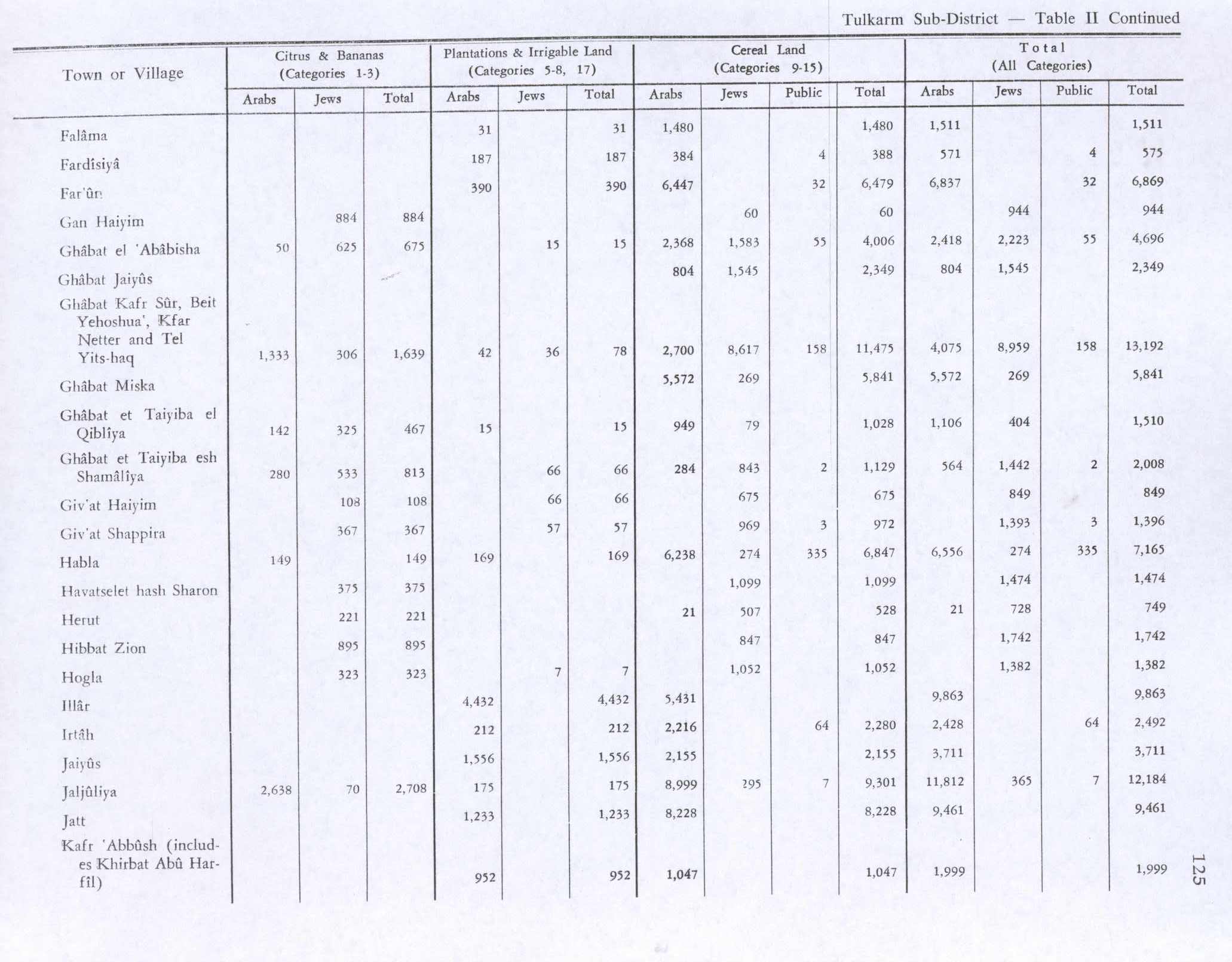
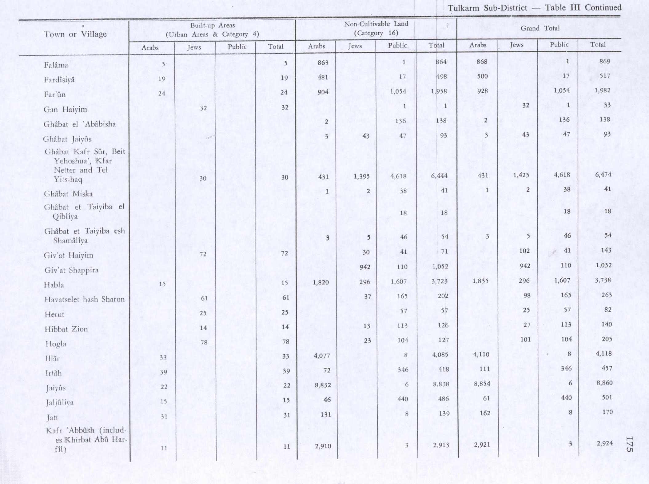
In the 1945 statistics, Fardisiya had a population of 20 Muslims[3] with a total of 1,092 dunums of land.[2] Of this, a total of 187 dunams were plantations and irrigated land, 388 dunums were for cereals,[14] while 19 dunams were classified as “built-up” areas.[15]
 Fardisya 1942 1:20,000
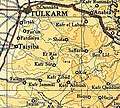 Fardisya 1945 1:250,000
1948, aftermath
The moshav Sha'ar Efraim is close to some of Fardisya's lands.[4]
References
- Palmer, 1881, p. 182
- Government of Palestine, Department of Statistics. Village Statistics, April, 1945. Quoted in Hadawi, 1970, p. 74
- Department of Statistics, 1945, p. 20
- Khalidi, 1992, p. 552
- Massarwa, 2009, Khirbat Fardisya
- Masarwa, 2008, Khirbat Fardisya
- Ibn al-Furat, 1971, pp. 82, 209, 249 (map)
- Hütteroth and Abdulfattah, 1977, p. 141
- Robinson and Smith, 1841, vol 3, Appendix 2, p. 128
- Guérin, 1875, p. 352
- Conder and Kitchener, 1882, SWP II, p. 164
- Barron, 1923, Table IX, Sub-district of Tulkarem, p. 27
- Mills, 1932, p. 54
- Government of Palestine, Department of Statistics. Village Statistics, April, 1945. Quoted in Hadawi, 1970, p. 125
- Government of Palestine, Department of Statistics. Village Statistics, April, 1945. Quoted in Hadawi, 1970, p. 175
Bibliography
- Barron, J. B., ed. (1923). Palestine: Report and General Abstracts of the Census of 1922. Government of Palestine.
- Conder, C.R.; Kitchener, H.H. (1882). The Survey of Western Palestine: Memoirs of the Topography, Orography, Hydrography, and Archaeology. 2. London: Committee of the Palestine Exploration Fund.
- Department of Statistics (1945). Village Statistics, April, 1945. Government of Palestine.
- Guérin, V. (1875). Description Géographique Historique et Archéologique de la Palestine (in French). 2: Samarie, pt. 2. Paris: L'Imprimerie Nationale.
- Hadawi, S. (1970). Village Statistics of 1945: A Classification of Land and Area ownership in Palestine. Palestine Liberation Organization Research Center.
- Hütteroth, Wolf-Dieter; Abdulfattah, Kamal (1977). Historical Geography of Palestine, Transjordan and Southern Syria in the Late 16th Century. Erlanger Geographische Arbeiten, Sonderband 5. Erlangen, Germany: Vorstand der Fränkischen Geographischen Gesellschaft. ISBN 3-920405-41-2.
- Ibn al-Furat (1971). J. Riley-Smith (ed.). Ayyubids, Mamluks and Crusaders: Selections from the "Tarikh Al-duwal Wal-muluk" of Ibn Al-Furat : the Text, the Translation. 2. Translation by Malcolm Cameron Lyons, Ursula Lyons. Cambridge: W. Heffer.
- Khalidi, W. (1992). All That Remains: The Palestinian Villages Occupied and Depopulated by Israel in 1948. Washington D.C.: Institute for Palestine Studies. ISBN 0-88728-224-5.
- Masarwa, Durar (2008-01-08). "Khirbat Fardisya Final Report" (120). Hadashot Arkheologiyot – Excavations and Surveys in Israel. Cite journal requires
|journal=(help) - Massarwa, Abdallah (2009-06-07), Khirbat Fardisya Final Report, Hadashot Arkheologiyot – Excavations and Surveys in Israel
- Mills, E., ed. (1932). Census of Palestine 1931. Population of Villages, Towns and Administrative Areas. Jerusalem: Government of Palestine.
- Morris, B. (2004). The Birth of the Palestinian Refugee Problem Revisited. Cambridge University Press. ISBN 978-0-521-00967-6.
- Palmer, E.H. (1881). The Survey of Western Palestine: Arabic and English Name Lists Collected During the Survey by Lieutenants Conder and Kitchener, R. E. Transliterated and Explained by E.H. Palmer. Committee of the Palestine Exploration Fund.
- Robinson, E.; Smith, E. (1841). Biblical Researches in Palestine, Mount Sinai and Arabia Petraea: A Journal of Travels in the year 1838. 3. Boston: Crocker & Brewster.
External links
- Welcome To Fardisya
- Fardisya, Zochrot
- Survey of Western Palestine, Map 11: IAA, Wikimedia commons